Results 1-15 of 15
<<< Previous 1 Next >>>
![[The Arctic Circle on globe sheets.]](img-thumbnail/jpegs/10905.jpg)
[The Arctic Circle on globe sheets.]
[n.d., c.1790.]
Pair of coloured engravings, two semi-cicles making a diameter of 340mm, 13½".
Pair of sheets apparently designed to be pasted onto a globe. In Arctic America the Mackenzie River is marked (discovered 1789) but the discoveries of Captain Cook in Alaska from 1778 are not. In the East Novaya Zemlya still has its early shape.
[Ref: 10905] £260.00
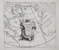
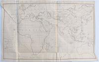
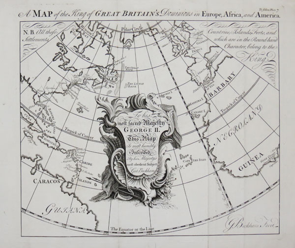
A Map of the King of Great Britain's Dominions in Europe, Africa, and America.
G. Bickham Fecit.
[n.d., 1748.]
Engraving. 280 x 315mm (11 x 12½"). Binding folds, worm holes in bottom margin.
A map centred on the Atlantic Ocean, showing from the Arctic Circle to the Equator, marking British possessions including Gibraltar, Minorca, the Gold Coast of Guinea and the colonies in North America and West Indies. From George Bickham's 'The British Monarchy or a Chorographical Description of all the Dominions Subject to the King of Great Britain'.
[Ref: 45602] £280.00
view all images for this item
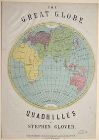
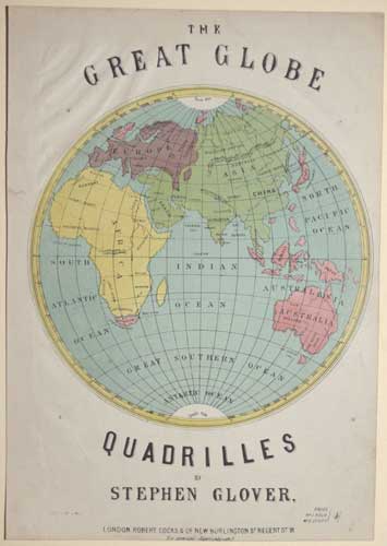
The Great Globe Quadrilles by Stephen Glover
[S. Rosenthal lith.]
London: Robert Cocks & C.o New Burlington S.t Regent S.t W. [n.d. c.1870]
Colour lithograph. 330 x 240mm (13 x 9½"). Trimmed with creasing in the top left corner and a small repaired tear in the upper left margin. Two worm holes in top left and bottom right corners.
An illustrated cover of the Eastern hemisphere for the sheet music to Stephen Glover's 'Quadrilles'.
[Ref: 56908] £190.00

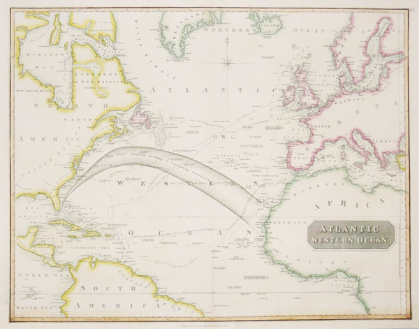
Atlantic or Western Ocean.
Drawn and Engraved for Thomson's New General Atlas. [Edinburgh: John Thomson, c.1815.]
Engraved map with original hand colour. 530 x 650mm (20¾ x 25½"). Paper pasted around printed border at bottom to hide damp stains.
A map of the North Atlantic from Iceland south to the Equator, with the Gulf Stream according to Thomas Pownall (1722-1805)', governor Massachusetts 1757-60) and author of 'Hydraulic and .Nautical Observations', an early examination of the Gulf Stream. Also marked is 'Lord Nelson's Track to the West Indies in Persuit of the French 1805' and 'Nelson Returning', which culminated at the Battle of Trafalgar. Another route is that of 'the United States Ship Insurgent', which operated in European waters during the 'Quasi-War' between the USA and France, caused by the US reneging on the loans given to them by France during the American War of Independence.
[Ref: 43581] £360.00
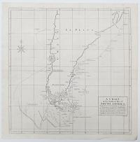
A Chart of the Southern Part of South America; With the Track of the Centurion from the Island of St Catherines to the Island of Juan Fernandes: In which is inserted the Variation and Soundings observ'd on board her, together with her Deviation from her estimated Course, occassioned by the force of the Currents.
R.W. Seale sculp.
[London: for the author by John and Paul Knapton, 1748.]
Engraved map. 530 x 500mm (20¾ x 19¾"). Folded as issued, splits in folds, paper toned.
A map of South America below Rio Grande in Brazil and Juan Fernandez Island in the Pacific (where Alexander Selkirk was marooned), marking the route taken by George Anson when rounding Cape Horn on his circumnavigation, 1740-44. The rough seas and gales meant that 'dead reckoning' was ineffective, so two estimated routes are shown south and west of the cape. On the map the Falklands have only a partial outline and, further north, the mythical 'Pepys Island', likely to be a mis-mapped Falkands, is marked. Anson's voyage was one of the last great buccaneering voyages, an official expedition to the South Seas to harass the Spanish bases but, more importantly, plunder their shipping. A main target was one of the richly-laden Manila galleons that crossed between Acapulco in Mexico and Manilla the Philippines. A stroke of luck presented them with one laden with 1.3 million silver pieces of eight; on their return to London, thirty-two wagons were needed to transfer them to the Tower of London. Published in Anson's own account, ''A Voyage Round the World, in the years MDCCXL, I, II, III, IV''.
[Ref: 43989] £350.00
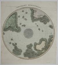
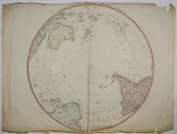
Southern Hemisphere.
Kirkwood Sculp.t.
[Drawn and Engaved for John Thomson & Co's New General Atlas 12 August 1814.]
Engraved map with original hand colour. Early example before the publication line, on paper watermarked 'J. Whatman 1811'. 570 x 520mm, 22½ x 20½". Creased.
A circular map of the Southern Hemisphere.
[Ref: 25645] £260.00

Southern Hemisphere. Pinkerton's Modern Atlas.
Drawn under the direction of Mr Pinkerton by L. Herbert.
London Published August 31st 1812 by Cadell & Davies, [...]
Engraved map with original hand colour, printed on J. Whatman 1810 watermarked paper. Sheet 550 x 790mm, 21¾ x 31". Trimmed into publication line, split in centrefold, tear in margin.
A circular map of the Southern Hemisphere.
[Ref: 25647] £260.00

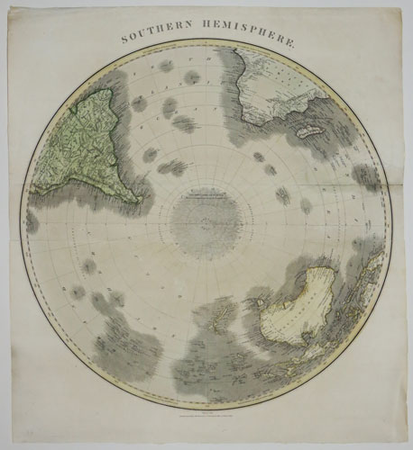
Southern Hemisphere.
London Published by W. Faden, Geographer to his Majesty, Charing Cross, Jan.y 1st 1822.
Engraved map with original hand colour. 480 x 520mm, 18¾ x 20½". Narrow margin at top, as issued, some creasing & tears.
A circular map of the Southern Hemisphere. Unusually, the lettering on the map is engraved in the round: the sheet has to be turned to read the names of the landmass closest to you.
[Ref: 25648] £180.00
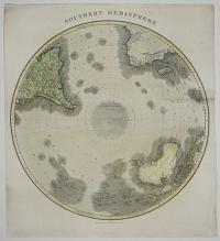
Southern Hemisphere.
Kirkwood Sculp.t.
Drawn and Engaved for John Thomson & Co's New General Atlas 12 August 1814.
Engraved map with original hand colour. 570 x 520mm, 22½ x 20½". Creased, tears.
A circular map of the Southern Hemisphere.
[Ref: 25653] £220.00
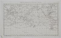
A General Chart, on Mercator's Projection, to Shew the Track of the Lion and Hindostan from England to the Gulph of China, and of their Return to England, with the daily statement of the Barometer and Thermometer as observed at noon; containing also the limits of the Chinese Empire, as extended by the Conquests of the present Emperor, Tchien-Lung.
J. Barrow del.t. B.Baker sculp.t.
Published April 12, 1796 by George Nicol.
Engraved map. Sheet 620 x 960mm (24½ x 37¾"). Creasing top left. Binding folds, one with a small split.
Map of the route taken by the George Macartney to China, heading the first British embassy to that country, 179294. It was published in Sir George Staunton's 'An Authentic Account of an Embassy from the King of Great Britain to the Emperor of China'.
[Ref: 38155] £450.00
![[Double-hemisphere world map.]](img-thumbnail/jpegs/51159.jpg)
[Double-hemisphere world map.]
[n.d., c.1800.]
Ink and watercolour on card. Sheet 45 x 60mm.
A charming miniature map.
[Ref: 51159] £130.00

A New Mercator's Chart Drawn from the Latest Discoveries.
W. Harrison sc.
London, Published January 1st. 1794, by Rt. Wilkinson No.58 Cornhill.
Engraved map of the world, in original hand colour. 280 x 450mm, 11 x 17¾". Vertical centrefold as normal, stained from reinforcement to verso.
Australia is captioned 'New Holland', while what is now the western part of the USA beyond the Rocky Mountains is 'New Albion'.
[Ref: 13066] £320.00

Typus Orbis Terrarum.
[Engraved by Jodocus Hondius.]
[London, Michael Sparke & Samuel Cartwright, 1635.]
Engraved map, 140 x 200mm, 5½ x 8", set in a page of letterpress. Impression of the map weak.
Originally engraved in 1607 by Jodocus Hondius for his "Atlas Minor", the printing plate of this map was sold to a London publisher when new, up-to-date plates were introduced. It was first used to illustrate Samuel Purchas's "Hakluytus Posthumus or Purchas His Pilgrimes" in 1625, then Sparke & Cartwright's "Historia Mundi or Mercator's Atlas", as this example. After thirty years' service the plate had become worn, resulting in a rather grey impression.
[Ref: 17431] £450.00
A Chart of the World, Exhibiting the Three Voyages of Capt.n Cook.
[n.d., c.1790.]
Engraved map. 195 x 310mm, 7¾ x 12½". Narrow margin on right due to binding.
A reduced version of the map of the world by Lieutenant Henry Roberts, who drew many of the maps published in the Official Account of Captain Cook's Third Voyage, during which he discovered Hawaii, where he was killed.
[Ref: 26390] £160.00
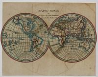
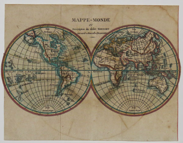
Mappe-Monde ou Description du Globe Terrestre Suivant les Nouvelles Decouvertes.
[n.d., c.1810.]
Engraved map with hand colour. Sheet: 180 x 235mm (7 x 9¼"). Trimmed around globes. Some staining.
A double-hemisphere world map, with a separately-printed, frame-like border. The map illustrates the discoveries of Cook's three voyages (1769-1779), with New Zealand, New South Wales and Hawaii following his surveys. Also, Tasmania is separate from mainland Australia, as proved by Flinders & Bass in 1802.
[Ref: 39456] £320.00
<<< Previous 1 Next >>>
![[The Arctic Circle on globe sheets.]](jpegs/10905.jpg)


![[Double-hemisphere world map.]](jpegs/51159.jpg)