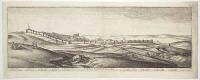
Prospec of ye North side of Tangier regarding the mayne Sea from the hill as you come from Whitby or the West toward the Torone,
J. Oliver Fecit.
J. Seller Excudit [1680]
Etching, 140 x 215mm. 5½ x 8½".
View of Tangier, from a series of six after Wenceslaus Hollar engraved by John Oliver and published by John Seller in his 'A Book of Sea Stories and Prospects' (1680). Seller (fl. 1660- d.1697) was also an important instrument maker, map and chart seller, and hydrographer to the king.
[Ref: 15895] £140.00
(£168.00 incl.VAT)

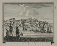
The South East corner of Tangier
J. Oliver Fc.
John Sellers Excudit [1680]
Etching, 140 x 215mm. 5½ x 8½".
View of Tangier showing the bay, port, 'Coast of Spaine' and 'Point of Gibralter', from a series of six Tangier views after Wenceslaus Hollar engraved by John Oliver and published by John Seller in his 'A Book of Sea Stories and Prospects' (1680). Seller (fl. 1660- d.1697) was also an important instrument maker, map and chart seller, and hydrographer to the king. see Pennington 1188 for Hollar's etching
[Ref: 15896] £140.00
(£168.00 incl.VAT)

The South-East Corner of Tangier, etc.
W. Hollar fecit.
[Published by John Overton, 1673.]
Etching, 17th century watermark. Sheet 125 x 215mm (5 x 8½"). Trimmed, tear in top left corner taped.
A view of the fortifications of Tangier, one of a series of views by Wenceslaus Hollar (1607-77) showing the city when it was an English possession (1671-84). Tangier came into English possession as part of Catherine of Braganza's dowry when she married Charles II in 1662, although attempts to develop it strategically and commercially were unsuccessful. In 1688 Hollar, in his capacity of 'Scenographus Regus', went there as part of a mission sent to deal with problems with hostile natives. Hollar made many sketches of the city (some now in the British Museum), depicting the fortifications that were demolished in 1684 when the English abandoned Tangier. Pennington 1188, state ii of iii
[Ref: 55506] £280.00
(£336.00 incl.VAT)

The South-East Corner of Tangier etc.
W. Hollar fecit
[Published by John Overton, 1673]
Etching, sheet 125 x 215mm (5 x 8½"). Glued to backing sheet.
The fortifications of Tangier, with the bay on the right and men sat smoking in the foreground. One of series of views in Tangier (modern Morocco) by Wenceslaus Hollar (1607-77). Tangier came into English possession as part of Catherine of Braganza's dowry when she married Charles II in 1662, although attempts to develop it strategically and commercially were unsuccessful. In 1688 Hollar, in his capacity of 'Scenographus Regus', went there as part of a mission sent to deal with problems with hostile natives. Hollar made some sketches of the fortifications, published in 1673. The fortifications shown were demolished in 1684 when the English government abandoned Tangier. Some of Hollar's drawings of Tangier are in the British Museum. Pennington 1188 iii/iii
[Ref: 42213] £190.00
(£228.00 incl.VAT)

The South-East Corner of Tangier, etc.
W. Hollar fecit.
[Published by John Overton, 1673]
Etching, sheet 125 x 215mm (5 x 8½"). Trimmed and laid on album sheet.
The fortifications of Tangier, with the bay on the right and men sat smoking in the foreground. One of series of views in Tangier (modern Morocco) by Wenceslaus Hollar (1607-77). Tangier came into English possession as part of Catherine of Braganza's dowry when she married Charles II in 1662, although attempts to develop it strategically and commercially were unsuccessful. In 1688 Hollar, in his capacity of 'Scenographus Regus', went there as part of a mission sent to deal with problems with hostile natives. Hollar made some sketches of the fortifications, published in 1673. The fortifications shown were demolished in 1684 when the English government abandoned Tangier. Some of Hollar's drawings of Tangier are in the British Museum. Pennington 1188 iii/iii
[Ref: 42675] £190.00
(£228.00 incl.VAT)
Prospect of Tangier from S. West.
W Hollar delineavit et sculp:
[Published by John Overton, 1673.]
Fine etching. 160 x 455mm (6¼ x 18"), with LVG 17th century watermark. Pinhole in image, vertical centre fold, creasing top right corner. Bit messy right margin.
A view of Tangier, with an 18-point key, one of the largest of a series of views by Wenceslaus Hollar (1607-77) showing the city when it was an English possession (1671-84). The watermark is that of Lubertus van Gerrevink, a paper mill in Egmond a/d Hoef, a major Dutch paper manufacturer in the C18th. Tangier came into English possession as part of Catherine of Braganza's dowry when she married Charles II in 1662, although attempts to develop it strategically and commercially were unsuccessful. In 1688 Hollar, in his capacity of 'Scenographus Regus', went there as part of a mission sent to deal with problems with hostile natives. Hollar made many sketches of the city (some now in the British Museum), depicting the fortifications that were demolished in 1684 when the English abandoned Tangier. Pennington 1199, only state.
[Ref: 59120] £550.00

Part of Tangier from above, without the Water-gate.
W Hollar delineavit et sculpsit 1670.
[Published by John Overton, 1673.]
Etching, 17th century watermark, sheet 125 x 215mm (5 x 8½"). Trimmed to image, some spotting and creasing.
A view of Tangier with the partly ruined water-gate on the right and vessels at anchor in the bay, one of a series of views by Wenceslaus Hollar (1607-77) showing the city when it was an English possession (1671-84). Tangier came into English possession as part of Catherine of Braganza's dowry when she married Charles II in 1662, although attempts to develop it strategically and commercially were unsuccessful. In 1688 Hollar, in his capacity of 'Scenographus Regus', went there as part of a mission sent to deal with problems with hostile natives. Hollar made many sketches of the city (some now in the British Museum), depicting the fortifications that were demolished in 1684 when the English abandoned Tangier. Pennington 1189, state ii of iii.
[Ref: 55521] £230.00
(£276.00 incl.VAT)

Part of Tangier from above, without the Water-gate.
W Hollar delineavit et sculpsit 1670
[Published by John Overton, 1673]
Etching, sheet 125 x 215mm (5 x 8½"). Glued to backing sheet.
View of Tangier with the partly ruined water-gate on the right and vessels at anchor in the bay. One of series of views in Tangier (modern Morocco) by Wenceslaus Hollar (1607-77). Tangier came into English possession as part of Catherine of Braganza's dowry when she married Charles II in 1662, although attempts to develop it strategically and commercially were unsuccessful. In 1688 Hollar, in his capacity of 'Scenographus Regus', went there as part of a mission sent to deal with problems with hostile natives. Hollar made some sketches of the fortifications, published in 1673. The fortifications shown were demolished in 1684 when the English government abandoned Tangier. Some of Hollar's drawings of Tangier are in the British Museum. Pennington 1189 ii/iii
[Ref: 42212] £190.00
(£228.00 incl.VAT)

Prospect of the West Side of Yorke Castle at Tangier right opposite to ye upper Castle, taken from the hill before the gate 1669
[Wenceslaus Hollar]
[Published by John Overton, 1673]
Etching, sheet 125 x 215mm (5 x 8½").
One of series of views in Tangier (modern Morocco) by Wenceslaus Hollar (1607-77). Tangier came into English possession as part of Catherine of Braganza's dowry when she married Charles II in 1662, although attempts to develop it strategically and commercially were unsuccessful. In 1688 Hollar, in his capacity of 'Scenographus Regus', went there as part of a mission sent to deal with problems with hostile natives. Hollar made some sketches of the fortifications, published in 1673. The fortifications shown were demolished in 1684 when the English government abandoned Tangier. Some of Hollar's drawings of Tangier are in the British Museum. Pennington 1196 ii/ii
[Ref: 42206] £190.00
(£228.00 incl.VAT)

Prospect of the West Front, of Tangier Castle,
W. Hollar delin.
[Published by John Overton, 1673]
Etching, sheet 125 x 215mm (5 x 8½").
One of series of views in Tangier (modern Morocco) by Wenceslaus Hollar (1607-77). Tangier came into English possession as part of Catherine of Braganza's dowry when she married Charles II in 1662, although attempts to develop it strategically and commercially were unsuccessful. In 1688 Hollar, in his capacity of 'Scenographus Regus', went there as part of a mission sent to deal with problems with hostile natives. Hollar made some sketches of the fortifications, published in 1673. The fortifications shown were demolished in 1684 when the English government abandoned Tangier. Some of Hollar's drawings of Tangier are in the British Museum. Pennington 1194
[Ref: 42208] £190.00
(£228.00 incl.VAT)

Prospect of Yorke Castle at Tangier, from ye Strand, and the North-West.
W Hollar delin: et sculps:
[Published by John Overton, 1673]
Etching, sheet 125 x 215mm (5 x 8½"). Trimmed to printed border, laid on album sheet.
Loaded carts drawn by horses travelling in front of York Castle in Tangier. One of series of views in Tangier (modern Morocco) by Wenceslaus Hollar (1607-77). Tangier came into English possession as part of Catherine of Braganza's dowry when she married Charles II in 1662, although attempts to develop it strategically and commercially were unsuccessful. In 1688 Hollar, in his capacity of 'Scenographus Regus', went there as part of a mission sent to deal with problems with hostile natives. Hollar made some sketches of the fortifications, published in 1673. The fortifications shown were demolished in 1684 when the English government abandoned Tangier. Some of Hollar's drawings of Tangier are in the British Museum. Pennington 1198 ii/ii.
[Ref: 42677] £190.00
(£228.00 incl.VAT)

Prospect of Yorke Castle at Tangier, from ye Strand, and the North-West.
W Hollar delin: et sculps:
[Published by John Overton, 1673.]
Etching, 17th century watermark. Sheet 125 x 215mm (5 x 8½"). Trimmed to printed border, tear in top left corner taped.
A view of the citadel of Tangier, with carts loaded with stone, probably for rebuilding the defences of the city, one of a series of views by Wenceslaus Hollar (1607-77) showing the city when it was an English possession (1671-84). Tangier came into English possession as part of Catherine of Braganza's dowry when she married Charles II in 1662, although attempts to develop it strategically and commercially were unsuccessful. In 1688 Hollar, in his capacity of 'Scenographus Regus', went there as part of a mission sent to deal with problems with hostile natives. Hollar made many sketches of the city (some now in the British Museum), depicting the fortifications that were demolished in 1684 when the English abandoned Tangier. Pennington 1198, state i of ii.
[Ref: 55508] £240.00
(£288.00 incl.VAT)

Prospect of Yorke Castle at Tangier, from ye Strand, and the North-West.
W Hollar delin: et sculp:
[Published by John Overton, 1673]
Etching, sheet 125 x 215mm (5 x 8½"). Glued to backing sheet.
Loaded carts drawn by horses travelling in front of York Castle in Tangier. One of series of views in Tangier (modern Morocco) by Wenceslaus Hollar (1607-77). Tangier came into English possession as part of Catherine of Braganza's dowry when she married Charles II in 1662, although attempts to develop it strategically and commercially were unsuccessful. In 1688 Hollar, in his capacity of 'Scenographus Regus', went there as part of a mission sent to deal with problems with hostile natives. Hollar made some sketches of the fortifications, published in 1673. The fortifications shown were demolished in 1684 when the English government abandoned Tangier. Some of Hollar's drawings of Tangier are in the British Museum. Pennington 1198 ii/ii
[Ref: 42210] £190.00
(£228.00 incl.VAT)
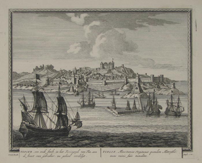
Tanger, een oude stadt in het Koningryk van Eez, aen de straet van Gibraltar...
Pet: Schenk.
Amst: C.P. [n.d., c.1702.]
Fine engraving, 215 x 270mm. 8½ x 10½".
A panorama with ships in the foreground of Tangier or Tangiers in northern Morocco. It lies on the North African coast at the western entrance to the Strait of Gibraltar, where the Mediterranean meets the Atlantic Ocean. Engraved and published in Amsterdam by Pieter Schenk (1660 - 1718/1719). Titles in Dutch, to left, and Latin. Plate to Schenk's 'Hecatompolis' (1702), which included one hundred profile views of cities throughout the world. Hollstein, vol XV, nos.1306-1405.
[Ref: 9754] £220.00
(£264.00 incl.VAT)
![Tangere [inscribed in banner cartouche in sky].](img-thumbnail/jpegs/10296.jpg)
Tangere [inscribed in banner cartouche in sky].
[Pieter van der Aa.]
[1702.]
Etching, 200 x 280mm. 7¾ x 11". Some paper discoloration.
A panorama from the sea, with ships, of Tangier or Tangiers in northern Morocco. It lies on the North African coast at the western entrance to the Strait of Gibraltar, where the Mediterranean meets the Atlantic Ocean. Plate to an atlas by Pieter van der Aa (1659 - 1733), Dutch publisher, mainly active in Leiden, best known for maps and atlases. He worked together with brother Balduinus under the joint name of Janssonii van der Aa.
[Ref: 10296] £80.00
(£96.00 incl.VAT)

Destruction of the ''Tanjore'' by Lightning off Ceylon.
Printed in Oiul Colours by G. Baxter, (Patentee) 11, Northampton Square.
[n.d., 1844.]
Rare Baxter print. Sheet 115 x 190mm (4½ x 3½"). Worm hole, some spotting, glue stains along bottom edge.
A ship on fire at night, the crew and passengers escaping in longboats.
[Ref: 66717] £130.00
(£156.00 incl.VAT)

Tantalizing. He that denies what Beauty has beseech'd,/ Should like the little Churl be overeach'd. [&] The Charmers. Music can soften pain to ease,/ And make despair and madness please:
The Revd. Mr. Peters R.A. Pinxt. Peters. C. Knight Sculpt. [&] Painted by the Revd. Mr. Peters. Engraved by C. Knight.
London Pub. Jan. 1. 1795, by C. Knight, No. 53, Piccadilly. [&] London: Published Novr. 1st. 1796, by C. Knight, at Mr. Bradshaw's, Brewer Street, Golden Square.
Pair of stipples with etching, each c.390 x 440mm. 15¼ x 17¼". Trimmed to lower platemark. Slightly soiled.
A girl and child by foliage laden with grapes or berries; in the second image four children, the nearest playing a lute with her back to the viewer, with two boys opposite singing from sheets of music, and a younger child to right playing a triangle. The artist is Matthew William Peters (1742-1814), most famous for his provocative painting of a courtesan (known as 'Lydia' in the mezzotint copy). He came to regret his choice of subject, as he was ordained in 1781, becoming the Royal Academy's chaplain (1784-8), then chaplain to the Prince of Wales. Lady Victoria Manners' 'Matthew William Peters, R.A.' p.65
[Ref: 10010] £420.00
view all images for this item
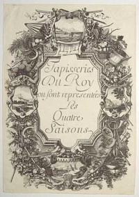
Tapisseries du Roy, ou sont Representées les Quatre Saisons.
I Bailly in. Le Clerc Sculp.
[n.d., c.1668.]
Engraving. 420 x 295mm (16½ x 11½"). Thread margins.
A decorative frontispiece to a set of engravings of the Four Seasons, with vignettes of the Seasons in a triumphal array.
[Ref: 55353] £140.00
(£168.00 incl.VAT)
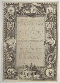
Tapisseries du Roy, ou sont Representées les Quatre Elemens.
I Bailly in. Le Clerc Sculp.
[n.d., c.1668.]
Engraving. 420 x 295mm (16½ x 11½"). Thread margins. Slight loss left corner.
A decorative frontispiece to a set of engravings of the Four Elements, with vignettes of the Elemetns in a triumphal array.
[Ref: 55354] £140.00
(£168.00 incl.VAT)

Devises Pour les Tapisseries des Quatre Elemens.
[n.d., c.1668.]
Engraving. 415 x 285mm (16¼ x 11¼"). Thread margins.
A decorative frontispiece to a set of engravings of the Four Elements, with vignettes of the Elements in a triumphal array.
[Ref: 55355] £140.00
(£168.00 incl.VAT)

Tapisseries du Roy, ou sont Representez les Quatre Elemens et les Quatre Saisons de L'Année.
I Bailly in.
[n.d., c.1668.]
Engraving. 415 x 285mm (16¼ x 11¼"). Trimmed to plate.
A decorative frontispiece to a set of engravings of the Four Elements and Four Seasons. It takes the form of a monument, with the Four Elements in a triumphal array above and the Four Seasons on the plinth below.
[Ref: 55352] £75.00
(£90.00 incl.VAT)
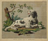
Model voor een haard-tapyt van Tapisserie Turque.
C. Borsteegh.del /D. Sluyter sculp.
[n.d., c1814].
Etching with hand colour. Prited area: 195 x 230mm (7¾ x 9"). Trimmed inside platemark. Glued to backing sheet as issued.
A design for a cross-stitch tapestry of a dog lying to the right, facing to the left, under an over-hanging branch with leaves.
[Ref: 32132] £120.00
(£144.00 incl.VAT)

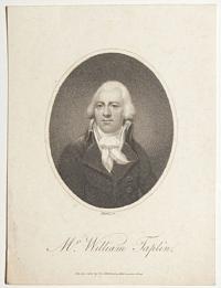
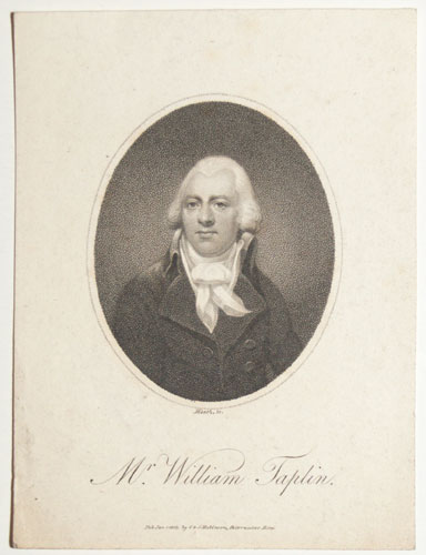
Mr. W. Taplin.
Walker, sc.
London. Published by G. Kersley MArch 10th 1789.
Stipple. Sheet 155 x 105mm (6 x 4¼"). Mounted in album paper.
A half-length portrait of William Taplin (1740-1807), author of 'The Gentlemans Stable Directory, A New Compedium of Farriery &c &c &c.', a guide to the management of hunters and road horses.
[Ref: 53303] £70.00
(£84.00 incl.VAT)
Mr. William Taplin.
Heath, sc.
Pub. Jan, 1. 1803 by G. & J. Robinson, Paternoster Row.
Engraving. Sheet 140 x 105mm (5½ x 4¼"). Trimmed within plate.
A half-length portrait of William Taplin (1740-1807), author of 'The Gentlemans Stable Directory, A New Compedium of Farriery &c &c &c.', a guide to the management of hunters and road horses.
[Ref: 53302] £45.00
(£54.00 incl.VAT)
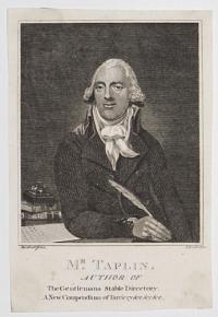
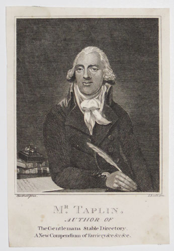
Mr. Taplin. Author of The Gentlemans Stable Directory, A New Compedium of Farriery &c &c &c.
Marshall pinx. I. Scott scu.
[n.d., c.1800.]
Engraving. Sheet: 145 x 100mm (5¾ x 4"). Trimmed.
A half-length portrait of William Taplin (1740-1807) author of a guide to the management of hunters and road horses.
[Ref: 46285] £130.00
(£156.00 incl.VAT)
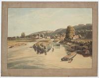
View of Taplow, taken from Maidenhead Bridge.
Drawn by W.m Havell. Engraved by R. Havell.
London, Published August 1 1818 by Thomas McLean.
Aquatint. 425 x 550mm (16¾ x 21½"). Small tear in title area, very small margins.
A view looking from Maidenhead in Berkshire up the Thames to Taplow in Buckinghamshire, painted by William Havell (1782-1857) and engraved by his cousin Robert Havell jnr. (1793-1878), famed for engraving most of Audubon's monumental 'Birds of America'. The paper around the image has been coloured to mimic board, the usual presentation of a watercolour.
[Ref: 43446] £450.00
![[George Tappin, Old George the Grave Digger]](img-thumbnail/jpegs/58083.jpg)
[George Tappin, Old George the Grave Digger]
E. Butler, del & lith. London. Printed by L.M. Lefevre.
Published by E. Buter, Reading [n.d., c.1832].
Rare lithograph. Sheet 270 x 220mm (10½ x 8¾"). Repaired tear in right edge. Pencil writing.
George Tappin (1785-1842), gravedigger at St Mary's Church, Reading, shown up to his waist in a grave, pick in one hand, spade handle with his initials to one side. The original painting, by Edward Butler (1810-1894), a local artist, bookseller & stationer, is in the Reading Museum, without the open grave. See Reading Museum 1947.45.1 for the painting.
[Ref: 58083] £140.00
(£168.00 incl.VAT)
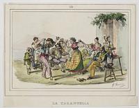
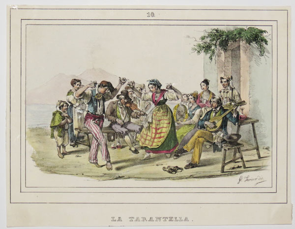
La Tarantella.
G. Torino dis.
[n.d., c.1840.]
Hand-coloured lithograph. Sheet: 210 x 165mm (8¼ x 6¼"). Trimmed.
An Italian scene showing two figures dancing the tarantella while a crowd watches and plays musical instruments.
[Ref: 44682] £85.00
(£102.00 incl.VAT)

"Tarantella".
D. Lewis Graves. '31. [pencil signature.]
Etching. Limited edition: 21/30. 312 x 235mm. 12¼ x 9¼". Crease to lower left-hand corner.
A young girl dancing a tarantella, an Italian folk dance usually accompanied by tambourines, with a pair of cymbals.
[Ref: 19197] £120.00
(£144.00 incl.VAT)
Tarczal.
Term. u és köre rajz Keleti Gusztáv. Özvegy Fuchs Györgyné müintézete. München.
[Budapest: Gustav Emich, 1867.]
Tinted lithograph. Printed area 190 x 265mm (7½ x 10½"). Large margins.
Tarcal in Hungary, from 'Tokaj-Hegyaljaer Album', a study of the famous Tokaj wine region by Josef Szabó & Stefan von Török. Gusztáv Frigyes Kelety (originally Klette, 1834-1902), a Hungarian painter, graphic artist and art critic.
[Ref: 38972] £95.00
(£114.00 incl.VAT)

A. Tardieu.
Ingres del. Henriquel Dupont sc.
Gazette des Beaux Arts. Imp. Drouart, Paris. [n.d., c.1860.]
Etching with stipple. Printed area 230 x 145mm (9 x 5¾").
Portrait of Pierre-Alexandre Tardieu (1756-1844) by Louis Pierre Henriquel-Dupont after J.A.D. Ingres. Tardieu is best known for his engraved portraits.
[Ref: 29766] £75.00
(£90.00 incl.VAT)
Unfortunately this item is either sold or reserved. If you are interested in similar items and cannot find what you're looking for on our website, please consider filling in our interests form. If you register, we can also send you items that match your interests when the website is updated.
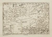
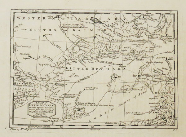
A Map of Little Bochara and the adjacent Countries. Drawn from the Survey of the Jesuits and Mr. Kyrillow's Map of the Russian Empire.
Tho.s Kitchin sculp.
[London: Richard Baldwin,1752-3.]
Engraved map. 170 x 250mm (10½ x 9¾"), with very large margins. Split in lower plate mark, chips in edges.
A map of the Tarim Basin in the western part of Xinjiang province of China, with Kasgar here called 'Hasikar or Hashgar'. From Thomas Salmon's 'The Universal Traveller: or, A compleat description of the several nations of the world'.
[Ref: 49635] £75.00
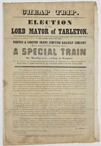
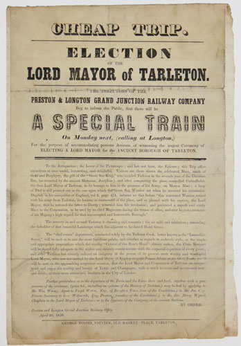
Cheap Trip. Election of the Lord Mayor of Tarleton. The Directors of the Preston and Longton Grand Junction Railway Company Beg to inform the Public, that there will be A Special Train On Monday next, (calling at Longton,) For the Purpose of accomodating persons desirous of witnessing the august Ceremony of Electing A Lord Mayor for the Ancient Borough of Tarleton.
April 20, 1850. George Bobins, Printer, Old Market Place, Tarleton.
Scarce letterpress broadside. Sheet 325 x 210mm (12¾ x 8¼"). Surface soiling, folded, laid on album paper.
[Ref: 40950] £120.00
(£144.00 incl.VAT)
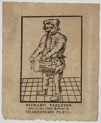
Richard Tarleton one of the first Actors in Shakespears Plays.
[n.d. c.1790.]
Woodcut engraving. Plate 122 x 83mm. 4¾ x 3¼".
Richard Tarlton (1539-1588) was an English actor, the most famous clown of his era. Dressed here in his clown's rustic apparel, with pipe and tabor. He was Queen Elizabeth's favourite clown. Harvard Volume IV. p.131: 1.
[Ref: 20963] £65.00
(£78.00 incl.VAT)
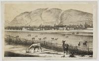
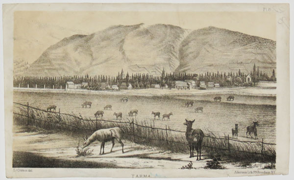
Tarma.
L.t Gibbon del.
Ackerman Lith 379 Broadway, NY.
Lithograph. Sheet: 210 x 130mm, (8¼ x 5"). Trimmed. Creasing and marking.
A view of the small town of Tarma in Peru from 'Exploration of the Valley of the Amazon' 1854 by Lt. Lardner Gibbon. The image shows the plentiful fields and pastures full of grazing sheep described by Gibbon in his account of the town.
[Ref: 40769] £65.00
(£78.00 incl.VAT)
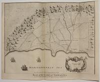
Plan of the Camp of Tarragona.
I. Basire Sculp.
For Mr Tindal's Continuation of Mr Rapin's History of England. [London, James & Paul Knapton, 1751.]
Engraved map. 390 x 480mm (15¼ x 19"). Very fine impression with original binding folds, trimmed into printed border at top, as issued.
A plan of the environs of the Catalan port of Taragona, a British base during the War of the Spanish Succession, as Catalonia was fighting for independence from Spain. The surrounding hills made for good natural defences, as the map notes: 'The Hills marked with a cross are impractical for cavalry'. Nicholas Tindal (1687-1774), at one time Chaplain to Greenwich Hospital, first published a translation of Frenchman Paul de Rapin's 'History of England' in 1727, running to thirteen volumes; in 1732 it was enlarged with his own notes and maps. This map was published in 'A summary of Mr Rapin de Thoyras's History of England, and Mr Tindal's Continuation, from the Invasion of Julius Caesar, to the End of the Reign of King George I. Illustrated With Medals, Plans of Battles, Towns, and Sieges', 1751.
[Ref: 28280] £140.00
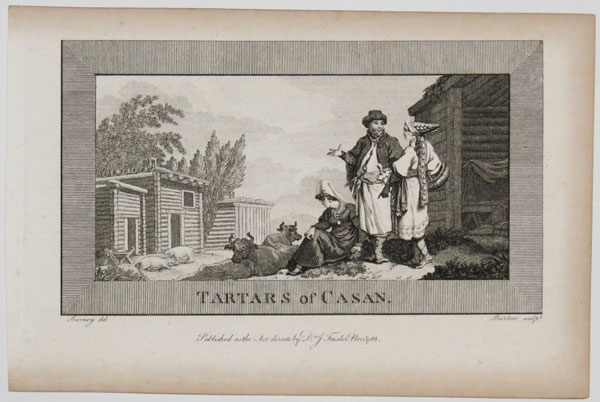
Tartars of Casan.
Burney del. Barlow sculp.t.
Published as the Act directs by Dr. J. Trusler Nov.r. 1788.
Engraving. 190 x 130mm (7½ x 5"). Trimmed to platemark.
View of a settlement of the Tartars of Casan in Northern Russia. Illustration from Dr John Trusler's 'The Habitable World Described' (c1788-1806).
[Ref: 32142] £60.00
(£72.00 incl.VAT)
![[Tartar Mountaineers.]](img-thumbnail/jpegs/31037.jpg)
[Tartar Mountaineers.] Vol.2.Pl.12.
Geisler del.t Medland Sculp.t
[John Stockdale.] [n.d. c.1812.]
Hand-coloured engraving with large margins; Stamp: Stamford Library. Plate 196 x 160mm (7¾ x 6¼").
Plate 12: two Tartar Mountaineers in their respective dresses. In the background are seen dwellings, one half of which is excavated in the rock. From Volume 2 of "Travels Through the Southern Provinces of the Russian Empire, in the Years 1793 and 1794".
[Ref: 31037] £80.00
(£96.00 incl.VAT)
![[Tartar Murses.]](img-thumbnail/jpegs/31044.jpg)
[Tartar Murses.] Vol.2.Pl.21.
Geisler del.t Medland sculp.
[John Stockdale.] [n.d. c.1812.]
Hand-coloured engraving with large margins; Stamp: Stamford Library. Plate 201 x 165mm (8 x 6½").
Plate 21: a group, consisting of two Tartar Murses, or Nobles, in their daily dress, both being faithful pictures drawn from nature; and a youth standing before them. In the background are seen the rocks beyond Kara-Ilas, on the banks of the Belbek; in front is delineated a fountain. From Volume 2 of "Travels Through the Southern Provinces of the Russian Empire, in the Years 1793 and 1794".
[Ref: 31044] £80.00
(£96.00 incl.VAT)

Habit of a Tartarian Lady. Dame Tartare. 37.
[Thomas Jefferys, n.d., c.1772.]
Hand coloured engraving, 18th century watermark. Plate 260 x 200mm (10¼ x 8"). Large margins.
Portrait of a Tartarian woman, in central Asia. She is walking to the left and touching her veil with both hands. Plate 37 from 'Collection of the dresses of different nations, antient [sic] and modern. Particularly old English dresses; after the designs of Holbein, Vandyke, Hollar and others, with an account of the authorities from which the figures are taken, and some short historical remarks on the subject. To which are added the habits of the principal characters on the English stage', published by Thomas Jefferys between 1757 - 1772.
[Ref: 62887] £140.00
(£168.00 incl.VAT)
![[Group of Tartars(?)] IVter Stamm.](img-thumbnail/jpegs/21052.jpg)
[Group of Tartars(?)] IVter Stamm. ['N.7' upper right.]
Brodtmann delin.
[Zurich: Brodtmann, n.d., c.1825.]
Lithograph, rare, sheet 445 x 335mm. 17½ x 13¼".
Three oriental figures in a landscape; a female and two males. From a natural history or ethnographic folio by renowned Swiss artist and lithographer Carl (Karl) Joseph Brodtmann (1787 - 1862).
[Ref: 21052] £140.00
(£168.00 incl.VAT)
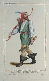
Tartare Orienteux. Tire de Nieuhof.
Touze
A.D.P.R. A Paris chez Duflos rue St. Victor. [n.d. c.1780]
Engraving with strong contemporary colour and a gold leaf line border. 278 x 166mm.
From 'Recueil d'estampes représentant les grades, les rangs et les dignités suivant le costume de toutes les nations existantes' by Pierre Duflos, published 1779-84. The original colour is particularly fine, with gold leaf highlights.
[Ref: 2104] £70.00
(£84.00 incl.VAT)
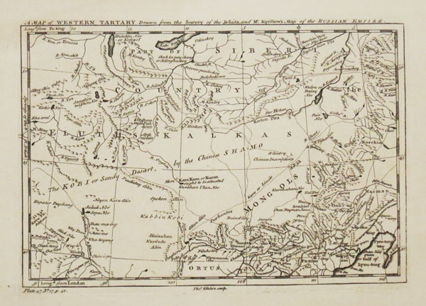
A Map of Western Tartary. Drawn from the Survey of the Jesuits and Mr. Kyrillow's Map of the Russian Empire.
Tho.s Kitchin sculp.
[London: Richard Baldwin, 1752-3.]
Engraved map. 170 x 240mm (10½ x 9½"), with very large margins. Chips in edges. Slight time staining.
A map of Mongolia, with southern Siberia and China to Beijing. Featured are the Great Wall of China, the Gobi Desert and Lake Baikal. From Thomas Salmon's 'The Universal Traveller: or, A compleat description of the several nations of the world'.
[Ref: 49634] £75.00

Le Grand Cam; Ou Empereur De Tartarie
.endroits et quantite de perles le long d'un lac appelle carnicla.
[Engraved by De Larmessin].
A Paris Chez P Bertrand Rue St. Iacques a la pomme d'Or proche St Seuerin, Avec Privil du Roy, [n.d. c.1685].
Engraving, with large margins; paper watermarked. Plate 228 x 160mm. 9 x 6¼".
Portrait of a Tartar emperor, bust-length, turned to the left, wearing fur-trimmed hat adorned with pearls and feather, pearl earrings, fur-trimmed cloak with jewellery, and holding a sceptre in right hand; in oval frame with ribbon tied in the upper part, and coat of arms in the lower part. From a large series of portraits, all following the same composition.
[Ref: 26191] £220.00
(£264.00 incl.VAT)

Tartini's Dream. Printed by C. Hullmandel.
[Louis Boilly.]
[n.d., c.1900.]
Photogravure. Sheet 190 x 260mm (7½ x 10¼"). Mounted on album paper, glue smears.
A photographic copy of Louis Boilly's caricature of a devil playing a violin at the end of Giuseppe Tartini's bed.
[Ref: 62816] £80.00
(£96.00 incl.VAT)
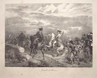
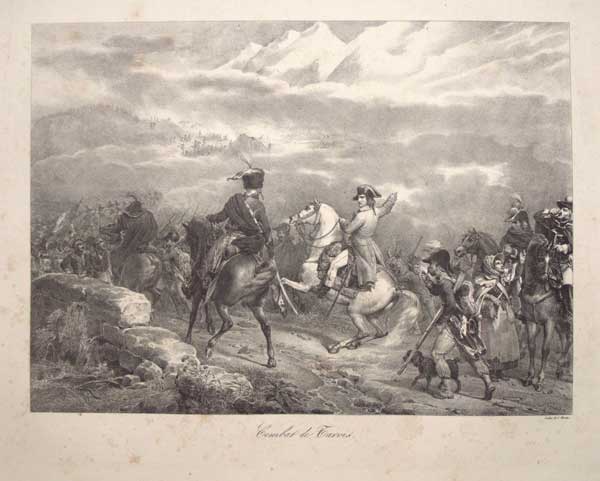
Combat de Tarvis.
F. Grenier. Litho: de C. Motte.
[n.d. c.1826.]
Lithograph. Printed area 315 x 400mm (12¼ x 15¾"), with large margins. Slight foxing.
Napoleon directing the Battle of Tarvis, fought 21-23 March 1797 near present-day Tarvisio in far northeast Italy, against the Austrians Published in A.V. Arnault's 'Vie politique et militaire de Napoléon', Paris, 1822-1826.
[Ref: 55866] £160.00
(£192.00 incl.VAT)
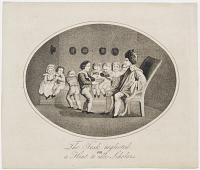
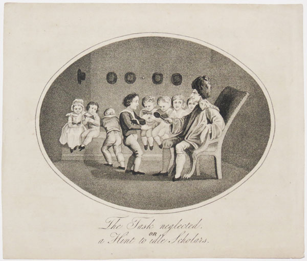
The Task Neglected, or a Hint to idle Scholars.
[n.d., c.1830.
Stipple, very rare. Sheet 190 x 225mm (7½ x 8¾"). Trimmed from larger sheet.
A schoolboy having his hand paddled. The back has music printed on it.
[Ref: 34214] £85.00
(£102.00 incl.VAT)

A Man of Cape Dieman in New Holland.
Prior del.t. A.W. Warren sculp.
[London: J. Debrett, 1800.]
Engraving. 210 x 165mm (8¼ x 6½"). Trimmed to plate on two sides, narrow margins elsewhere.
A profile of an Aboriginal man, copied from the plate after Jean Piron. From the English edition of Jacques Labillardière's ''An Account of A Voyage in search of La Perouse... Under the Command of Rear-Admiral Bruni d'Entrecasteaux'', an expedition that crossed the South Pacific, visiting Australia, New Zealand and the East Indies between 1791-3.
[Ref: 58734] £130.00
(£156.00 incl.VAT)

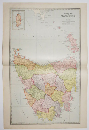
General Map of Tasmania.
The Picturesque Atlas Publishing Company, Limited, Sydney & Melbourne. [n.d., 1886-8.]
Colour-printed wood engraving (chromoxylograph). Printed area 610 x 370mm (24 x 14½"). Centre fold as issued. Large margins.
A map of Tasmania, divided into districts, with an inset of King Island. On the reverse is an index and a vignette wood engraving of cut logs floating down a river. It was published in the 'Picturesque Atlas of Australasia, a periodical issued between 1886-88, timed for the celebration of the centenary of the arrival of the First Fleet in 1888. This was the largest publication project attempted in the Australian colonies, with 50,000 subscribers, roughly 1.3 of the population. Codell: Imperial Co-histories, p. 219-220.
[Ref: 39135] £90.00
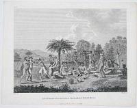
Savages of Cape Diemen Preparing their Meal.
Piron del. Harding ex. I. Walker sc.
Pub.d Apr. 20. 1800 by J. Debrett Piccadilly.
Engraving. 229 x 292mm. 9 x 11½".
Savages of Rocky Bay, off Tasmania, preparing their repast. From the English edition of Jacques Labillardière's ''An Account of A Voyage in search of La Perouse... Under the Command of Rear-Admiral Bruni d'Entrecasteaux'', an expedition that crossed the South Pacific, visiting Australia, New Zealand and the East Indies between 1791-3.
[Ref: 20747] £140.00
(£168.00 incl.VAT)


![Tangere [inscribed in banner cartouche in sky].](jpegs/10296.jpg)


![[George Tappin, Old George the Grave Digger]](jpegs/58083.jpg)


![[Tartar Mountaineers.]](jpegs/31037.jpg)
![[Tartar Murses.]](jpegs/31044.jpg)

![[Group of Tartars(?)] IVter Stamm.](jpegs/21052.jpg)