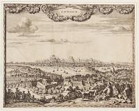
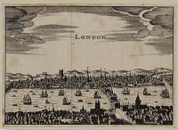
![[London prospect] Multum in Parvo.](img-thumbnail/jpegs/50283.jpg)
[London prospect] Multum in Parvo.
[n.d., c.1750.]
Engraving. Sheet: 70 x 105mm (2¾ x 4''). Trimmed. Slight loss on left.
The vignette from the title page of an edition of the London Magazine showing a prospect of London from Southwark, with London Bridge stil lcovered with buildings. The title below translates as 'a great deal in a small space'.
[Ref: 50283] £95.00
(£114.00 incl.VAT)
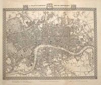
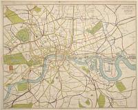
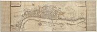
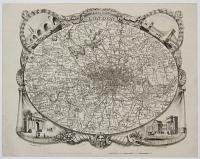
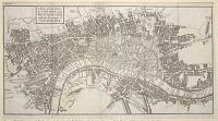
A Plan of London and its Environs. Drawn and Engraved for Lewis' Topographical Dictionary.
Drawn by R. Creighton. Engraved by J. & C. Walker.
[n.d., c.1831.]
Engraved map. Sheet 430 x 510mm (17 x 20"). Trimmed within plate on left, folds, laid on album paper.
A detailed map of central London, an example of the first state, before the addition of London's first steam railway, the London and Greenwich Railway (opened between 1836-38). Darlington & Howgego 330.
[Ref: 61731] £260.00
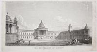
The University of London constituting the most wonderful aggregation of institutions to be found anywhere in the World. To the Memory of the Founders and Benefactors of the noble Colleges and Schools of the University of London this plate is gratefully and respectfully dedicated.
Designed, Executed & Published by S. Gordon Wilson. Copyright and under the approval of the Vice-Chancellor.
[n.d., c.1923.]
Etching. Sheet 290 x 635mm (11½ x 25"). Repaired tear at top, some surface abrasions in margins.
22 vignette illustrations of the buildings and numerous crests of the University. Wilson published a book with a similar title in 1923.
[Ref: 50664] £320.00
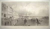
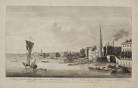
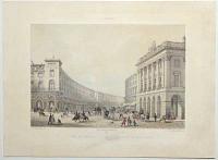
London from Somerset House, looking East.
Drawn by T. Allom. Engraved by T.A. Prior.
Published by J. & W. Robins, 57 Tooley Street, London [n.d., 1842].
Engraving on steel. 230 x 415mm (9 x 16¼"). Trimmed.
A pre-Embankment view of Somerset House, looking toward Blackfriars Bridge and St Paul's Cathedral.
[Ref: 56563] £230.00
(£276.00 incl.VAT)
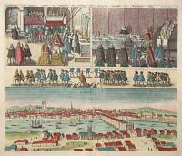
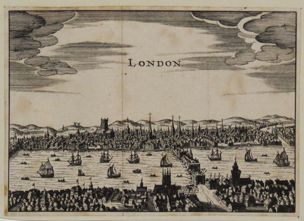
Abilltung wie königliche Maistät in Engelandt Die Artickel Dess Spanischen Heyraths Jur: Bekreftiget Anno 1623. Lunden.
[Cologne: Abraham Hogenberg, 1627.]
Coloured engraving. 270 x 320mm (10¾ x 12½"). Evidence of crack in printing plate (as the BM example).
Four scenes relating to the Spanish Match treaty, from Kaspar Ens' ''Fama Austriaca'': James I signing the treaty in the Chapel Royal; James dining with the Spanish ambassador; James in procession; and a prospect of London, with the Norman St Paul's Cathedral. In 1614 a Spanish embassy arrived in London to reach agreement to stop English privateers attacking Spanish shipping in the Americas and prevent England joining the Thirty Years' War. In return Spain would cease supporting opponents of James's rule in Ireland. Spain also proposed the marriage of the Spanish Infanta to Charles, Prince of Wales (later Charles I), promising a dowry of half-a-million pounds. James, who desperately needed money, was enthusiastic, but Parliament refused to accept any deal and James dissolved it in fury. It eventually transpired that the Infanta had no intention of marrying a protestant, and Spain was just stringing out negotiations to stop England entering the war. In 1625 Charles married Henrietta Maria of France instead.
[Ref: 57336] £380.00

Prospects of the most remarkable places in and about the Citty of London, Neatly Engraved.
[London: Henry Overton, c.1724.]
Engraving. Plate: 165 x 245mm (6½ x 9¾"), with large margins. Marking in margins.
The title page to 'Prospects of the most remarkable places in and about the Citty of London, Neatly Engraved' published by Henry Overton with title in French and English.
[Ref: 45355] £280.00
(£336.00 incl.VAT)
The University of London. From the Designs of W. Wilkins, M.A., R.A.
Eng.d by Tho.s Higham [c.1840]
Engraving, sheet 240 x 450mm (9½ x 17¾"). Surface abrasions.
The main building of University College London, constructed between 1825 and 1832 to designs by the architect and antiquary William Wilkins (1778-1839). Like Wilkins' other projects of the period, his ideas were stimulated by reading the works of John Howard, Jeremy Bentham, and continental Enlightenment authors.
[Ref: 46930] £140.00
(£168.00 incl.VAT)

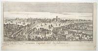
Londra Capitale dell'Inghilterra. Tom XII. A. Il fiume Tamigi. B. Il Ponte. C. La Torre. D. Il Palazzo di Whitehall. E. Il Borgo di Southwark.
[Fran. Sesone.]
[n.d. c.1740.]
Engraving. Plate 177 x 342mm (7 x 13½"). Trimmed along upper plate edge, folds as normal.
A pre-fire prospect of London, engraved by Sesone and probably copied from Schenck's view of London (for which see ref. 28514).
[Ref: 48570] £280.00
(£336.00 incl.VAT)
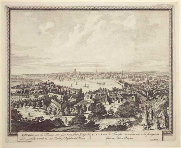
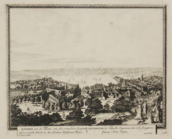
Londen aen de Theems een seer vermaerde Koopstadt van de gantsche Werelt en des Konings Residenzie Plaats. Londinum ad Tamesin Emporium toto orbe famigeratis simum, Sedes Regia.
Pet Schenk exc: amst: cum privil:
[n.d. c.1702.]
Engraving. 210 x 260mm (8¼ x 10¼"). Mounted on album paper. Small margins.
A view of London before the Great Fire of 1666, taken from an imaginary hill south of the Thames. In the centre is the Norman St Paul's Cathedral; London Bridge is filled with houses; and the Tower of London appears on the right.
[Ref: 62053] £450.00

A North View of London. Vue Septentrionale de la Ville de Londres.
Canaleti Delin. Stevens Sculpt.
Publish'd according to Act of Parliament. [Published 12th May, 1794, by Laurie & Whittle, 53, Fleet Street, London.]
Engraving. Sheet 250 x 395mm (10 x 15½"). Trimmed within plate, losing publication line, mounted on card at edges.
A view of London from the bowling green at Islington, showing the New River Head waterworks and Sadler's Wells in the foreground. After Antonio Canaletto (1697-1768).
[Ref: 62018] £290.00
(£348.00 incl.VAT)
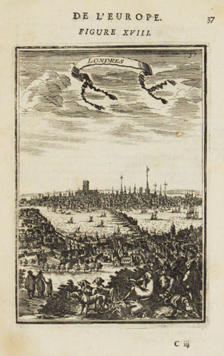
Londres.
[after Alain Manesson Mallet.]
[Paris: Denys Thierry, 1683.]
Engraving. 150 x 105mm (6 x 4¼"), set in letterpress, very large margins.
A prospect of London based on Claes Janszoon Visscher's view of 1616, from Mallet's classic five-volume work 'Description de l'Univers'.
[Ref: 51158] £180.00
(£216.00 incl.VAT)

A Plan of Hyde Park and Part of the City of London, shewing A Position for A Royal Palace, with a Proposed Street, leading directly from thence to S.t Paul's, as suggested by Colonel Tremch. The design for the Palace and the Street, by Phil.p Wyatt, Arch.t.
G. & J. Cary, sculp, 86 S.t James's Street.
[n.d., c.1827.]
Engraved map with hand colour. 185 x 695mm (7¼ x 27½"), with 'J. Whatman 1824' watermark. Folds, laid on album paper with a lithograph.
A plan for a new Royal Palace in Hyde Park with a new road carved in a straight line through London's West End to St Paul's Cathedral. It also shows Sir Frederick William Trench's plan for a Thames Embankment. Despite George IV's enthusiasm neither palace nor road was built. The additional etching is 'Design for laternal instead of the present frontal Pavillion's for the New Palace St James Park intended to groupe with the marble arch of Georgius Quartus', 'Designd and etched by William Bardwell'. It is an elevation of a massive neo-classical facade.
[Ref: 64132] £360.00
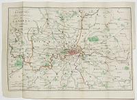
![Plan of the Cities of London and Westminster, with the Borough of Southwark, exhibiting all the New Buildings to the present Year MDCCCVI [1806].](img-thumbnail/jpegs/64140.jpg)
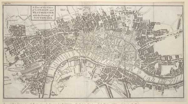
Plan of the Cities of London and Westminster, with the Borough of Southwark, exhibiting all the New Buildings to the present Year MDCCCVI [1806].
Neele sculp. 350 Strand.
Pub.d by T. Hughes Stationers Court, April 21.st 1806.
Engraved map. Sheet 405 x 730mm (16 x 28¾"). Trimmed within plate, binding folds flattened with repairs, nicks in edges. Damaged.
An early 19th century map of London with 'An Alphabetical List of 340 Principal Streets' underneath. The extents of the map are Knightsbridge in the west, clockwise to Paddington, Islington, Hackney, Stratford-le-Bow, the East India Docks, Limehouse, Newington Butts, Chelsea Waterworks and Sloane Square.
[Ref: 64140] £320.00
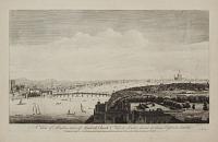
View of London from Greenwich Park.
J. Farington R.A. del. J.C. Stadler sculp.
Pub. Jine 1, 1796, by J. & J. Boydell, Shakespeare Gallery, Pall Mall, and N,, 90, Cheapside.
Etching with aquatint sheet 460 x 585mm (16½ x 23"). Hinged into mount. Vertical folds as normal. Faint mount burn from a previous mount.
Panoramic view of London from the park, looking towards St Paul's with the river Thames and shipping to the right.
[Ref: 55032] £360.00
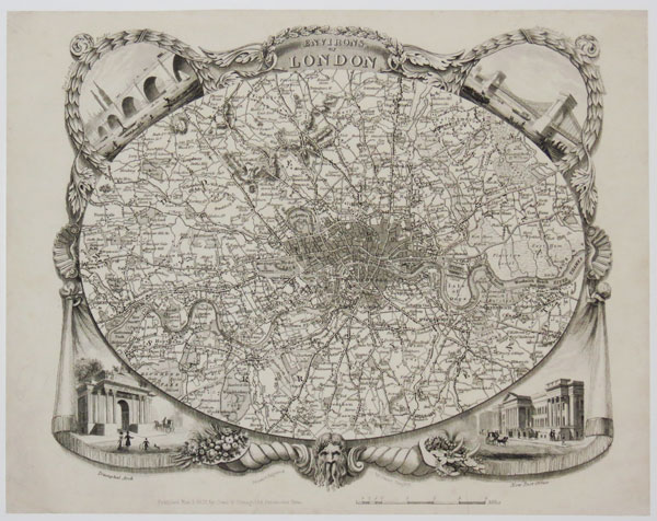
Clue Plan for Collins's Illustrated Guide To London By J. Batholomew.
William Collins, Sons & C.º London, Glasgow & Edinburgh [n.d., c.1871.]
Rare wood-engraved map, printed in colours and hand finished. Sheet 190 x 365mm (7½ x 14¼"). Original folds, mounted on card at corners.
A map of the roads of London, with landmarks and railways. Not in Hyde's Victorian Maps of London.
[Ref: 61749] £360.00

A Correct Plan of the Cities of London and Westminster & Borough of Southwark, including the Bills of Mortality, with the Additional Buildings &c. Engraved from a New Survey for the London Magazine 1761.
Engraved map. 230 x 410mm (9 x 16"). Trimmed into plate on left, original binding folds.laid on card.
A map of London based on John Rocque's important 24-sheet map of 1746. The Bills of Mortality were the areas in Greater London that reported death notices directly to the London government. Darlington & Howgego 118.
[Ref: 61741] £360.00

London.
Printed in the Year 1683.
Two engravings, trimmed and conjoined, laid on album sheet. Total printed area 160 x 190mm (6¼ x 7½").
An amalgam of two engraved titlepages. Above are the arms of Charles II on an architrave; below is a stylised prospect of London from the south, with an odd Pre-Fire Norman St Paul's Cathedral and three theatres grouped close together on the South Bank, including Shakespeare's Globe.
[Ref: 61728] £260.00
(£312.00 incl.VAT)
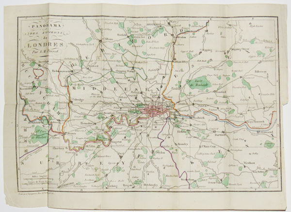
Panorama des Environs Londres, Par A.M. Perrot.
Gravé par Legagneur, Rue de la Harpe, No. 35.
[n.d., but 1828.]
Engraved map with original colour. Printed area 210 x 310mm (8¼ x 12"). Folded as issued.
A tourist's map of the environs of London, extending from Windsor east to Gravesend and from Ware south to Reigate. From the 'Guide de l'Étranger a Londres'.
[Ref: 37603] £260.00
Plan des Villes de Londres et de Westminster et de leurs Faubourgs avec le Bourg de Southwark.
C. Inselin sculp.
Avec Priv. du Roy 1700.
Engraved map. Plate: 340 x 230mm (13½ x 9"), with wide margins.
Nicolas de Fer's map of London showing the City of London and Westminster.
[Ref: 42750] £390.00
London.
P.H. Schut fecit. N. Visscher excudit.
[n.d., c.1666.]
Engraving. Sheet: 270 x 215mm (10½ x 8½"). Trimmed and laid on album sheet. Slight creasing.
A view of London from Southwark across to the city showing the extent of the Great Fire of London in 1666. An illustration from a Dutch broadside, published by Visscher describing the event.
[Ref: 42363] £650.00

Prospect der Stadt London in England.
A. Sommer fec.
J. Eder ex. [Vienna, n.d. c.1795.]
A very rare engraving. Plate 173 x 262mm (6¾ x 10¼"), large margins.
A stylised prospect of London from the south, with an almost-unrecognisable St Paul's Cathedral, The Monument and London Bridge still with buildings on it. The engraving is based on the Kip prospect: it shows the Folly, the floating tea-room, but incorrectly downstream of London Bridge.
[Ref: 53204] £220.00
(£264.00 incl.VAT)

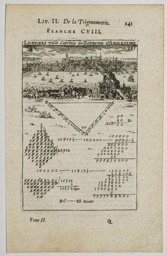
Londres ville Capitale du Royaume d'Angleterre.
[after Alain Manesson Mallet.]
[Paris: Denys Thierry, 1683.]
Engraving. 150 x 105mm (6 x 4¼"), set in letterpress.
A prospect of London based on Claes Janszoon Visscher's view of 1616, here used to illustrate the principles of triangulation. From Mallet's classic five-volume work 'Description de l'Univers'.
[Ref: 49504] £140.00
(£168.00 incl.VAT)

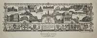
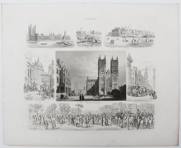
London. Die Westminsterabtei.
[Emil Wendt.][n.d.,c.,1850]
[Leipzig, Berlag von Dürffling und Frante.]
Engraving, platemark 270 x 315mm (10½ x 12½") very large margins.
A collection of vignettes of views of London arranged around a central view of Westminster Abbey, other views include 'Hyde-Park', 'Der Tower', 'Das Parlamentshaus'. A plate from Emil Wendt's 'Bilderatlas der Länderkunde...'
[Ref: 46031] £120.00
(£144.00 incl.VAT)

Londres. Les Capitales De L'Europe. Promenades Pittoresques. Londres. Paroisse de Ste. Mary-le-Bone.
Par M. Charles Malo.
Paris, Marcilly Fils Ainé, Rue S.-Jacques, No.21. Imprimerie de A. Firmin Didot, Rue Jacob, No.24. Relié chez Boullenger Md. Papetier-Relieur. Rue de la Paroisse. No.53 a Versailles. [n.d. c.1829.]
Small 12mo book, 36 pages, pink board cover embossed and with title printed in black; with hand-coloured aquatint. 152 x 95mm. 6 x 3¾". Some foxing.
Charles Malo (1790-1871) produced a series of books on the capital cities of Europe, in French, and recorded details of daily life in the cities, historical information and architectural details of churches and significant public buildings. The frontispiece is a view of the Parish of St. Marylebone.
[Ref: 17660] £260.00
view all images for this item

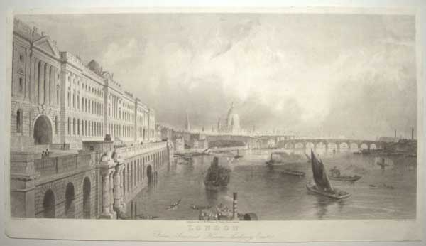
To S.r Hugh Smithson Bar.t, This View of the City of London Taken through one of the Centers of the Arches of the New Bridge at Westminster and Engrav'd from a Painting of Canaletti, is most hum.bly Dedicated by hus most Obliged Humble Servant. John Brindley.
Canaletti Pinx. S. Wale delin. R. Parr Sculp.
Publish'd according to Act of Parliament 1747.
Very Scarce engraving. 435 x 590mm (17 x 23¼"), with large margins. Slight centre fold.
Canaletto (Giovanni Antonio Canal, 1697-1768) lived in London from 1746 to 1756, the early part coinciding with the building of Westminster Bridge, which was only the second bridge to be built in the metropolis. This view of London was taken from under one of the arches of the bridge, with the wooden buttressing in place, three years before the bridge opened. The original oil is in the Duke of Northumberland's collection in Syon House. Canaletto also painted both Sion House and the Duke's London home, Northumberland House. A fine panorama of London from the River.
[Ref: 52903] £1,150.00
Londra Capitale dell'Inghilterra. Tom XII. A. Il fiume Tamigi. B. Il Ponte. C. La Torre. D. Il Palazzo di Whitehall. E. Il Borgo di Southwark.
Fran. Sesone sculp Nap.]
[Naples, n.d. c.1740.]
Engraving. Plate 177 x 342mm (7 x 13½"). Trimmed along upper plate edge, folds as normal.
A pre-fire prospect of London, engraved by Sesone and probably copied from Schenck's view of London (for which see ref. 28514). However the engraver, Francesco Sesone, has reversed the image, so London Bridge is to the west of St Paul's! This image was published before the error was spotted and corrected. See Ref: 28516 for added hand colour and different publication.
[Ref: 56179] £360.00

Londres.
A Paris chez Crepy rue St. Jacques a St. Pierre [n.d., c.1700].
Etching, 180 x 230mm (7 x 9"). A fine impression, with very large margins.
London and Southwark, with London Bridge crossing the River Thames. With description and key below title. From a series of city prospects; probably engraver and publisher Louis Crépy (1680 - 1754 after), son of Jean.
[Ref: 27810] £550.00

Londres Ville Capital du Royaume d'Angleterre.
Fait par Avelin.
a Paris chez Crepy rue St. Jacques a St. Pierre [n.d., c.1700].
Engraving. 215 x 315mm (8½ x 12½"), with very large margins.
A pre-fire prospect of London and Southwark, with London Bridge crossing the River Thames, with the Norman St. Paul's Cathedral, a key below title. From a series of city prospects; the publisher is Jean or Louis Crépy.
[Ref: 27811] £580.00
Londen aen de Theems een seer vermaerde Koopstadt van de gantsche Werelt en des Konings Residenzie Plaats. Londinum ad Tamesin Emporium toto orbe famigeratis simum, Sedes Regia.
Pet Schenk exc: amst: cum privil:
[n.d. c.1702.]
Engraving. 210 x 260mm (8¼ x 10¼").
A view of London before the Great Fire of 1666, taken from an imaginary hill south of the Thames. In the centre is the Norman St Paul's Cathedral; London Bridge is filled with houses; and the Tower of London appears on the right.
[Ref: 28514] £450.00

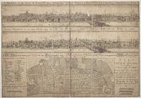
Londra Capitale dell'Inghilterra. Tom XII. A. Il fiume Tamigi. B. Il Ponte. C. La Torre. D. Il Palazzo di Whitehall. E. Il Borgo di Southwark.
[Francesco Sesone.]
[n.d. c.1740.]
Engraving. Plate 177 x 342mm (7 x 13½"). Trimmed along upper plate edge, folds as normal.
A pre-fire prospect of London, engraved by Sesone and probably copied from Schenck's view of London (for which see ref. 28514). See Ref: 28516 for added hand colour and different publication.
[Ref: 28515] £280.00
(£336.00 incl.VAT)

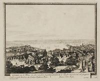
Londra Capitale dell'Inghilterra. Tom XII. Pag 14. A. Il fiume Tamigi. B. Il Ponte. C. La Torre. D. Il Palazzo di Whitehall. E. Il Borgo di Southwark.
Fran. Sesone Sculp. Nap.
[n.d. c.1740.]
Engraving with added hand colour. Plate 153 x 343mm (6¾ x 13½"). Folding.
A pre-fire prospect of London, engraved by Sesone. However he has reversed the image, so London Bridge is to the west of St Paul's! This image was published before the error was spotted and corrected. See Ref: 28515 for uncoloured impression with corrected view.
[Ref: 28516] £220.00
(£264.00 incl.VAT)
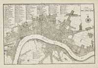
A Plan of London as in Q. Elizabeths days.
London. Printed for T. Bowles at N.º 43 in Cornhill [n.d., c.1750].
Engraved map. Sheet 175 x 550mm (6¾ x 21¾"). Trimmed to printed border, losing half of plate; paper toned, some stains.
A map of London in Tudor times, based on the large woodcut map often attributed to Ralph Agas. Originally published c. 1700 by John Bowles. The missing lower half of the plate contained a prospect of London after Visscher and five views.
[Ref: 61744] £450.00
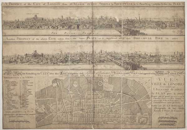
A Prospect of the City of London from S.t Marie Overs Steeple In Southwark in its flourishing Condition before The Fire. Another Prospect of the above City taken from the Same Place as it Appeared after that Dreadfull Fire in 1666. A Plan for Rebuilding the City after the Fire, Designd by that Great Architect S.r Christoph.r Wren and approvd of by King and Parliament but unhappily Defeated by Faction.Vues de la Ville de Londres Comme il doit devant & apres lincendie de 1666. Avec le plan pour la rebâtir. Projetté par ce grand architecte le chevalier Chrsitopher Wren, & aprouvé par le roi & parliament; mais malheureusement rejetté par faction.
[Prospects after Wenceslaus Hollar.]
Publiè par Jean Rocque, Chorographe de Son Altesse Royalle le Prince de Galles.
Engraved map. Sheet 360 x 315mm (14½ x 12½"). Dissected and laid on linen, trimmed close to printed border, some surface loss top centre & top left, stains and creases, mounted on card.
Sir Christopher Wren's plan for rebuilding London after the Great Fire of 1666, with copies of Wenceslaus Hollar's prospects of the city before and after the fire. Rare: OCLC records only two institutional examples, in the British Library and the Yale Centre for British Art
[Ref: 61745] £1,650.00

London. in England [ms]
[n.d., c.1720.]
Engraving. Sheet 245 x 225mm (9½ x 9"). Trimmed to image; staining lower left; repaired tear and crease through centre.
German prospect of London from south of the Thames, with many buildings numbered for identification by a key (not included). The position, south of London Bridge, gives a particularly precise view of Borough, Southwark and Bermondsey. For similar view published in France see ref. 30819.
[Ref: 38624] £480.00
London
[Anon., c.1700]
Engraving, sheet 105 x 150mm (4 x 6"). Cut to image.
London and Southwark, with London Bridge crossing the River Thames. The panorama features St. Paul's Cathedral in its previous gothic incarnation, before the Wren building that was completed in 1708. This suggests a piracy of an engraving made before the Great Fire of London of 1666, or that the plate pre-dates the adoption of Wren's design. Possibly derived from a larger but similar view published in a French series of city prospects by Crépy. For Crépy's view see ref. 27811.
[Ref: 38641] £160.00
(£192.00 incl.VAT)
![No 11. The River. St Pauls from Southwark London. [pencil]](img-thumbnail/jpegs/38937.jpg)
No 11. The River. St Pauls from Southwark London. [pencil]
J. Brown Gibson. [pencil]
[n.d., c.1930.]
Scarce etching. 300 x 405mm (11¾ x 16"). Very large margins.
Scottish artist James Brown Gibson (1880-1961).
[Ref: 38937] £320.00

Londres. Vue de Pont de Waterloo.
Alph. Leroy del. Lith. de Langlumé.
[n.d., c.1840.]
Lithograph. Printed area 210 x 265mm (8¼ x 10½"). Very large margins.
The famouse view, looking up the Thames to Blackfriars Bridge and St Paul's Cathedral.
[Ref: 39335] £180.00
(£216.00 incl.VAT)

Londres.
[n.d., c.1720.]
Engraving. Sheet 200 x 275mm (8 x 10¾"). Trimmed to image, laid on old album paper.
A prospect of London from south of the Thames. Christopher Wren's new St Paul's Cathedral is shown but not accurately, suggesting it was based on the designs rather than the building finished in 1711.
[Ref: 30819] £280.00
(£336.00 incl.VAT)
Environs of London.
Drawn and Engraved by James Bingley.
Published Nov 3 1828 by Cowie & Strange, 64 Paternoster Row.
Rare steel-engraved map. Sheet 210 x 270mm (8¼ x 10½"). Small repaired tear affecting publisher's inscription.
An oval map of the environs of London, extending to Finchley in the north, clockwise to Tottenham, Barking, Woolwich, Norwood, Tooting, Wimbledon, Richmond, Brentford and Hendon. Within the decorative borders are vignette view of London Bridge, Hammersmith, Hyde Park Corner and the Post Office. At the bottom is the head of Old Father Thames and twin cornucopiæ (horns of plenty) filled with fruits and jewels representing the trade coming up the river. The design of this separate-issue map was later copied by Thomas Moule for his county atlas. Howgego No. 315.
[Ref: 37605] £280.00
![[Prospect of Pre-Fire London]](img-thumbnail/jpegs/61736.jpg)
[Prospect of Pre-Fire London]
[after Pieter Hendrickszoon Schut]
[n.d., c.1680.]
Etching. Sheet 200 x 250mm (8 x 9¾"). Trimmed into image, stains, laid on album paper.
A prospect of London before the Great Fire of 1666, from an imaginary hill south of the Thames, with people and dogs in the right foreground. Possibly a later state of Schut's broadsheet view of the Fire of London published by Visscher in 1666, with the flames removed, as well as Schut & Visscher's names, and the key under the dogs. See BM 1872,0113.592 for Schut's original.
[Ref: 61736] £320.00

London.
Drawn, Engraved and Published by John Swertner, Maudlin Lane, St. James's, Bristol, July 1st 1801.
Hand coloured aquatint. Printed area approx: Unexamined out of frame. Vertical crease to right where previously folded.
A view of London from the north (Islington); St Paul's central at mid-distance; fields in foreground with figures working on harvest, Islington church to the right. Print made by Johannes Swertner (1746 - 1813) a Moravian Minister who, in 1787 ascended the spire of St Mary's church, (depicted in print) which was being fitted with a lightning conductor at the time, in order to study London from a height.
[Ref: 29192] £1,250.00
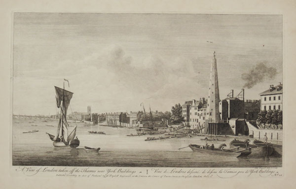
A View of London taken off the Thames near York Buildings. Veüe de Londres dessiné de dessus la Tamise, pres de York Buildings. No.22.
John Boydell Delin. & Sculp.
Publish'd according to Act of Parliament, & Sold by J.no Boydell Engraver at the Unicorn the Corner of Queen Street Cheapside London. [n.d c.1770.]
Engraving, paper watermarked with very large margins. Plate 260 x 430mm (10¼ x 17").
A view of York Buildings waterworks, on the Thames riverside near the Strand. The tower is the York Buildings Company's octagonal 70-ft water tower, built in the late 17th century, with supplied up to 2,500 housholds with water. In the background are Westminster Abbey and Bridge. Also visible are the houses of the Duchess of Portland, Earl of Pembroke, Sir Thomas Robinson, Mrs. Dunch, Black Lion Stairs, and Villiers Street. On the far right is part of the Salt Office, formerly Samuel Pepys' house. From "A Collection of One Hundred Views In England and Wales". John Boydell's 'Collection of Views' was made after he turned from engraver to print publisher in 1767. The first collection was issued in 1770, and included some plates by printmakers other than himself. Adams (London): 47.22; Hugh Phillips, 'The Thames around 1750' p.116
[Ref: 29315] £450.00
A View of London taken off Lambeth Church. Veüe de Londres dessinè de dessus lEglize de Lambeth. No.24.
J.no Boydell Delin & Sculp.
Publish'd according to Act of Parliament, & Sold by J. Boydell Engraver at the Unicorn the corner of Queen Street Cheapside London 1752. Price 1s.
Engraving, paper watermarked with very large margins. Plate 260 x 430mm (10¼ x 17").
Fine view of London looking from Lambeth towards the centre of London. Westminster Abbey and bridge in middle-distance, St Paul's in the distance. From "A Collection of One Hundred Views In England and Wales". John Boydell's 'Collection of Views' was made after he turned from engraver to print publisher in 1767. The first collection was issued in 1770, and included some plates by printmakers other than himself. Adams (London): 47.24.
[Ref: 29317] £450.00
![A View of London as it was in the Year 1647. 45. [&] Vüe de Londres comme il etoit dans LAn. 1647. 46. [with numbered key both in English and French.]](img-thumbnail/jpegs/29381.jpg)
A View of London as it was in the Year 1647. 45. [&] Vüe de Londres comme il etoit dans LAn. 1647. 46. [with numbered key both in English and French.]
R. Benning del. et sculp.
Sold by J. Boydell Engraver at the Unicorn in Cheapside London 1756.
Panoramic view on two sheets; engraving, paper watermarked with very large margins; rare in good condition. Plate 305 x 489mm (12 x 19¼").
A long view of London as it was in 1647, before the Great Fire, from Westminster Abbey to St. Katharine's and Essex on the north side of the Thames. Very detailed view of Southwark on the south of the Thames in the foreground. From John Boydell's 'A Collection of One Hundred Views In England and Wales', compiled after he turned from engraver to print publisher in 1767. The first collection was issued in 1770, and included some plates by engravers other than himself. Adams (London): 47.45 & 46.
[Ref: 29381] £1,500.00
view all images for this item
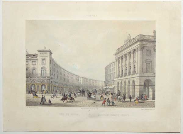
Londres. Rue du Regent. Quadrant, Regent Street.
Ch. Rivière del. et lith. Imp de Godard r. du Jardinet, 13.
Paris. Mainson Martinet [n.d., c.1860].
Tinted lithograph with some hand colour. Printed area 205 x 260mm (8 x 10¼"). Bit messy.
A view of Regent Street from Piccadilly Circus, after Nash's colonnade was demolished to deter thieves and prostitutes.
[Ref: 57666] £180.00
(£216.00 incl.VAT)
![Londinium Antiqua. This Plan shews the ancient extent of the famous cities of London and Westminster as it was near the begining of the Reign of Queen Elizabeth [...]](img-thumbnail/jpegs/35662.jpg)
Londinium Antiqua. This Plan shews the ancient extent of the famous cities of London and Westminster as it was near the begining of the Reign of Queen Elizabeth [...]
Vertue, Soc. Antiq. London excudit 1737.
Engraving on pewter, two sheets (of eight) conjoined, total 355 x 940mm. Repairs to folds. Ink stamps of the Paul Mellon Collection on reverse.
The bottom left corner of a map of Tudor London, engraved on pewter by George Vertue from a comtemporary woodcut in the possession of Sir Hans Sloane. The strip here shows Westminster, Whitehall, Lambeth Palace and Charing Cross, the buildings south of the Strand and Fleet Street, to St Paul's Cathedral and Barnard's Castle. Under the title is a list of buildings not present, as a guide to dating the map. Three examples of an anonymous woodcut map of London c.1570 exist, all now in institutions. Vertue, an enthusiastic member of the Society of Antiquaries, researched the map and attributed it to Ralph Agas (c.1540-1621), solely on the basis of a letter in which Agas spoke of his intentions of making such a plan. The style is much the same as Braun & Hogenberg, with the buildings shown in profile, and many of the details are shared. However on this plan St Paul's Cathedral is without the spire hit by lighting and destroyed in 1561 (not shown here as the building runs off the top of the present sheet). Howgego: Printed Maps of London 8, and the introduction pp.7 - 8.
[Ref: 35662] £1,800.00
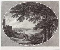
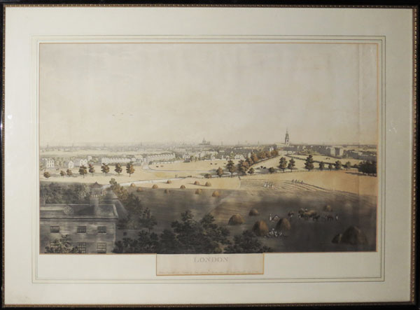
A view of London from Flamstead Hill in Greenwich Park.
Drawn by Tho.s Hearne. Etch'd by Eliz & Engrav's by W.m Ellis.
[n.d., c.1786].
Engraving and etching. Printed area: 390 x 495mm (15¼ x 19¾"). Trimmed inside platemark. Few repaired tears.
A landscape view of London from Greenwich, with the Royal Observatory on the left, in a trompe l'oeil oval. A family can be seen on a hill in the foreground overlooking the Thames with ships moored, and the silhouette of St Paul's Cathedral on the horizon. The image framed by trees at right and the edge of a building with figures on the terrace at left.
[Ref: 32502] £360.00

London. Londres en Ballon. Excursions Aériennes.
Dessiné d'Après nature et lith. par Jules Arnout.
Paris, Bulla Frères et Jouy, Rue Tiquetonne, 18. London, Gambart, Junin & Co, 15 Berniers S.t. Oxf. S.t. [n.d., c.1850.]
Coloured lithograph. 355 x 455mm (14 x 18").
A view of London looking down from a hot air balloon, another in the distance. Taken from above Elephant and Castle, it shows Brunel's Hungerford Suspension Bridge and the Houses of Parliament before the completion of Big Ben's Clock Tower.
[Ref: 51348] £680.00
A Plan of the Cities of London and Westminster with the Borough of Southwark.
[London: R. Dodesley, 1744.]
Engraved map. Sheet 230 x 420mm (9 x 16½"). Trimmed within plate on three sides, folds and creasing, slight ink offset, laid on album sheet
A map of London, extending from Park Lane in the west, clockwise to Marylebone, Sadlers Wells, Hoxton, Bethnal Green, Rotherhithe and Lambeth. The map shows the extent of the damage caused by the Great Fire of 1666. From "The Geography of England". Darlington and Howgego 92.
[Ref: 61743] £360.00
![[Port of London.]](img-thumbnail/jpegs/43774.jpg)
[Port of London.] To the Right Hon.ble Lord Hawkesbury, &c. &c. This Perspective Sketch illustrating a design submitted to the consideration of the Select Committee of the House of Commons on the improvement of the Port of London, Is inscribed by his obedient humble Servant, Geo. Dance.
Designed by Geo. Dance, Prof.r of Archit.e in the Royal Acad.y & Arch.t to the City of London. Will.m Daniell fecit.
Published as the Act directs, for Geo. Dance Esq. R.A. Upper Gower Street, London, Nov.r 10 1800.
Coloured aquatint. Sheet 400 x 660mm (15¾ x 26"). Trimmed within plate, central fold, tears in margins.
A fully-formed illustration showing George Dance's vision of the redevelopment of the Port of London, with Old London Bridge replaced by two bridges, both with drawbridges to allow ships further upstream. Set between the bridges are the Monument and a proposed 'Naval Trophy', a pillar commemorating the achievements of the Navy, design by James Barry. Old London Bridge was eventually replaced by one designed by John Rennie.
[Ref: 43774] £950.00
![[London prospect] Multum in Parvo.](jpegs/50283.jpg)


![Plan of the Cities of London and Westminster, with the Borough of Southwark, exhibiting all the New Buildings to the present Year MDCCCVI [1806].](jpegs/64140.jpg)


![No 11. The River. St Pauls from Southwark London. [pencil]](jpegs/38937.jpg)


![[Prospect of Pre-Fire London]](jpegs/61736.jpg)

![A View of London as it was in the Year 1647. 45. [&] Vüe de Londres comme il etoit dans LAn. 1647. 46. [with numbered key both in English and French.]](jpegs/29381.jpg)
![Londinium Antiqua. This Plan shews the ancient extent of the famous cities of London and Westminster as it was near the begining of the Reign of Queen Elizabeth [...]](jpegs/35662.jpg)


![[Port of London.]](jpegs/43774.jpg)