Catalogue: England

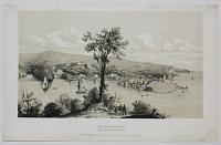
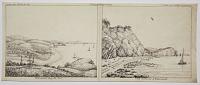
View of Manningtree from Highlands.
1851.
Watercolour in sepia tones. Sheet size: 270 x 350mm (10½ x 13¾"). Glued to backing sheet in corners.
A fine watercolour view of Manningtree, Essex, England from Highlands House, in the village of East Bergholt in Suffolk, just north of the Essex border. Bridges crossing the river Stour can be seen in the centre, with two large windmills in the distance. The high level of skill and accuracy of the painting would suggest that it was made by an architect.
[Ref: 37759] £180.00
(£216.00 incl.VAT)
![Sulgrave Manor [pencil]](img-thumbnail/jpegs/49228.jpg)
Sulgrave Manor [pencil] Just Published. ''Sulgrave Manor'' (The Home of the Washington Family) Original Drypoint by H. Goffey. (Limited Edition)
John G Mathieson [signed in pencil.]
[London: Alfred Bell & Co., n.d., c.1930.]
Drypoint etching, signed by the artist. 230 x 305mm (9 x 12") very large margins. In original mount with printed label with publisher's logo of a black bell with ABC in white. Mint.
Sulgrave Manor, a Tudor house in south Northamptonshire, once owned by the ancestors of George Washington. Harry Goffey (1871-1951).
[Ref: 49228] £140.00
(£168.00 incl.VAT)

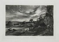
Summer Evening.
Painted by John Constable R.A. Engraved by David Lucas.
London, Pub.d by M.r Constable, 35 Charlotte S.t Fitzroy Square 1831.
Mezzotint. Plate: 250 x 175mm (9¾ x 7"), with very large margins. Slight foxing.
A view of a rural landscape, a field near East Bergholt, after a oil painting by Constable now housed in the V&A. From about 1829 Constable and Lucas worked together on a series of mezzotints after sketches and paintings by Constable called 'Various Subjects of Landscape...' published in parts between 1830 and 1832. In 1843 Charles Robert Leslie published his 'Memoirs of John Constable Esq. R.A'. He obtained directly from the Constable family 186 sets of 22 images of the Various Subjects of Landscape in return for 30 copies of his book. This mezzotint is one of those; "see Tate John Constable, David Lucas". Wedmore 7. Shirley: 6. Osbert Barnard: II of V.
[Ref: 44387] £230.00
(£276.00 incl.VAT)
Summer Evening.
Painted by John Constable R.A. Engraved by David Lucas.
London, Pub.d by M.r Constable, 35 Charlotte S.t Fitzroy Square 1831.
Mezzotint on india. 250 x 175mm (9¾ x 7"), with very large margins.
A view of a rural landscape, a field near East Bergholt, after a oil painting by Constable now housed in the V&A. From about 1829 Constable and Lucas worked together on a series of mezzotints after sketches and paintings by Constable called 'Various Subjects of Landscape...' published in parts between 1830 and 1832. Wedmore 7. Shirley: 6. Osbert Barnard: I of V.
[Ref: 50865] £230.00
(£276.00 incl.VAT)
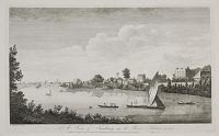
A View of Sunbury, up the River Thames. No.2.
J. Boydell Del. & Sculp.
Publish'd according to Act of Parliament by J. Boydell at the Unicorn the Corner of Queen Street Cheapside. Price 1.s. [n.d. c.1750.]
Engraving, printed on 18th century watemarked paper. Plate 260 x 431mm. 10¼ x 17". Large margins.
A view of Sunbury-on-Thames, in Surrey. Punts, boats and merchant vessel seen on the River Thames. See Ref: 859. Collage: k1274478.
[Ref: 25623] £350.00
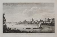
A View of Sunbury, up the River Thames. No.2.
J. Boydell Del. & Sculp.
Pulish'd according to Act of Parliament by J. Boydell at the Unicorn the Corner of Queen Street Cheapside. Price 1s. [1770.]
Engraving, paper watermarked with very large margins. Plate 260 x 425mm (10¼ x 16¾").
A view along the River Thames at Sunbury, from "A Collection of One Hundred Views In England and Wales". John Boydell's 'Collection of Views' was made after he turned from engraver to print publisher in 1767. The first collection was issued in 1770, and included some plates by printmakers other than himself. Adams (London): 47.2.
[Ref: 29295] £250.00
(£300.00 incl.VAT)

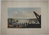
Sunderland Pier, Durham.
Drawn & Engraved by Will.m Daniell.
Published by W. Daniell, Cleveland Street, Fitzroy Square, London, July 1, 1822.
Aquatint with fine original hand colour. 230 x 300mm (9 x 12"). Watermarked 'J. Whatman Turkey Mill 1821'. Mint, with large margins, uncut.
A view of Tynemouth with the ruins of Tynemouth Priory, the lighthouse and fishing boats. From William Daniell's 'A Voyage Round Great Britain', a series of 308 aquatints published in eight volumes between 1814-1825, described by R.V. Tooley as 'the most important colour plate book on British Topography'. Abbey: Scenery, 16; Tooley: Books with Coloured Plates 177.
[Ref: 35966] £180.00
(£216.00 incl.VAT)

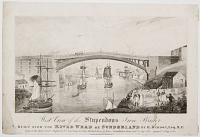
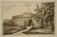
West View of the Stupendous Iron Bridge Built over the River Wear in Sunderland by Row.d Budron Esq.r M.P. under the immediate inspection of Mr T. Wilson Engineer.
Engraved by T.A. Kidd N.Castle on Tyne.
Jan.y 1. 1805. Published by W. Tarn, Sunderland.
Engraving. Sheet 145 x 215mm (5¾ x 8½"). Trimmed, laid on album paper at edges.
The world's second iron bridge, opened 1796.
[Ref: 42019] £110.00
(£132.00 incl.VAT)
![[Old Sunderland.]](img-thumbnail/jpegs/51970.jpg)
[Old Sunderland.]
[by Thomas Marie Madawaska Hemy.]
Published by Hills & Co, Printsellers, Sunderland, Nov.r 1st 1888.
Scarce etching. 430 x 560mm (17 x 22") with wide margins. Limited edition 85, Artists Proof 35, Before Letters 50; Printsellers' Association blindstamp.
An extremely rare view of the River Wear at Ettrick's Quay, Sunderland, half-a-century before it was cleared for the creation of Corporation Quay (1932). The original painting by Hemy (1850-1937) is in the Tyne & Wear Archives & Museums.
[Ref: 51970] £420.00
West View of the Stupendous Iron Bridge Built over the River Wear in Sunderland by Row.d Budron Esq.r M.P. Span of the Arch 256 F.t Height 100 F.t Cast Iron 214 Tons. Worked Iron 46 Tons. Foundation Stone Laid 24 SEp. 1795. Opened 9 Aug. 1796.
Published by T. Robson [c.1805]
Engraving. Sheet 165 x 240mm (6½ x 9½"). Trimmed, losing part of publication line.
The world's second iron bridge, opened 1796. For similar view of the bridge see ref.42019.
[Ref: 46025] £95.00
(£114.00 incl.VAT)
![[Wearmouth Bridge] A South East View of the Cast Iron Bridge over the River Wear at Sunderland in the C.o of Durham.](img-thumbnail/jpegs/54167.jpg)
[Wearmouth Bridge] A South East View of the Cast Iron Bridge over the River Wear at Sunderland in the C.o of Durham. Built by Roland Burdon Esq.r M.P. Span 236 Ft, height 100 Ft, Spring of the Arch 33 Ft, It is supposed to be the Largest Arch in the World - The Foundation Stone was laid 24th Sept, 1793 & the Bridge was opened 9th Aug.t 1796.
R. Johnson Delt. A.Hunter Scult.
[n.d. 1796]
Rare engraving. Sheet 355 x 420mm (14 x 16½"). Trimmed to plate, repaired tears.
A view of the first Wearmouth Bridge, shortly after it opened, showing that masted ships could pass underneath it easily. It was the second major cast-iron bridge in the world, but twice as long as the Severn Iron Bridge, with an unprecedented single span of 236ft. The bridge was designed and built by the engineer Thomas Wilson, sponsored by Rowland Burdon.
[Ref: 54167] £650.00
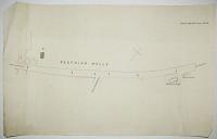
Seething Wells.
[n.d., c.1850?]
Ink sketch map. Sheet 425 x 680mm (16¾ x 26¾"). Tears.
A sketch map of the Brighton Road from near the Thames Ditton Marina to the Fox & Hounds public house at Westfield Road, with Brighton Road (to Surbiton) marked 'From Brighton'. It is possible this was drawn when both Chelsea Water Works and Lambeth Waterworks were about to be relocated to Seething Wells in 1852 after their original sites were declared too polluted to provide drinking water safely.
[Ref: 49013] £160.00

Edwards's General Map of 1400 Square Miles... Also all the Great Roads leading from London to Brighthelmston...
Published as the Act directs, 15 July 1817, by J. Edwards, Obervatory Old Brompton, Middlesex.
Engraved map with original colour. 290 x 600mm, 11½ x 23½". Two folds, as issued.
Uncommon map of the area between London and the south coast of England on a scale of 1:25, orientated with north to the left. Its primary focus is the route from London to Brighton, during the reign of the Prince Regent, with the map designed to also show Windsor Castle. Coastal towns include Eastbourne, Newhaven, Shorham and Worthing. From Edwards' "Tabulæ Distantiæ".
[Ref: 17716] £220.00

Surrey and Sussex. Railways. 28.
[James Reynolds, London 1863]
Hand coloured engraving, sheet 185 x 240mm ( 7¼ x 9½"). Folded as issued, time staining along taped fold.
From 'Reynolds's Geological Atlas of Great Britain'. A map of the railways showing ones under constuction and stations.
[Ref: 56923] £40.00

Swanwich Bay, from the North Side. Durlstone Bay. Plate 29.
Drawn by Tho.s Webster. Engraved by George Cooke.
London; Published by Payne & Foss, Pall Mall, 1816.
Rare hand-coloured engraving, J. Whatman watermark 1815. 315 x 475mm (12½ x 18¾"). Folding crease in the middle, some foxing and blue stains. Small margins.
Two panoramic views of Swanage Bay and Durlston Bay, south of Swanage, Dorset. Plate 29 of 'A Description of the principal Picturesque Beauties, Antiquities and Geological Phenomena of the Isle of Wight' by Sir Henry C. Englefield (1816).
[Ref: 59814] £190.00
(£228.00 incl.VAT)
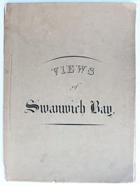
Views of Swanwich Bay.
Drawn by H. Gastineau from a Sketch by a Lady & on Stone by G. Barnard [& W. Gauci]
Printed by C. Hullmandel. [n.d., c.1840.]
Very scarce set of 4 lithographs on india, stitched in original printed wrappers, plus extra lithograph inserted loose. Sheets: 380 x 280mm (15 x 11") with large margins. Slight paper tone to backing paper of loose print.
A set of five views of Swanage Bay in Dorset.
[Ref: 42853] £580.00
view all images for this item
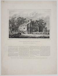
Swarthmore Hall, near Ulverstone. Residence of George Fox.
On stoneby Geo. Lehman. P. S. Duval, Lith. Phil.e.
[n.d., c.1830].
Lithograph with letterpress, scarce with very large margins. Sheet size: 435 x 330mm (17 x 13").
Swarthmoor Hall is a mansion in Swarthmoor, in the Furness area of Cumbria in North West England. It was the home of Thomas and Margaret Fell, the latter an important player in the founding of the Religious Society of Friends (Quaker) movement in the 17th century. Founder of the Quaker movement, George Fox (1624 - 1691) visited the Hall in 1652 when Thomas Fell was travelling as a judge. However, Fox had an audience with Margaret Fell who became interested in his new doctrines. When Thomas Fell returned home, he was persuaded by his wife and some others to listen to Fox, who successfully appealed to his pro-Parliamentary sentiments. Thomas Fell was never totally convinced by Fox's religious teachings, but he did allow his home to be used as a meeting house for the early Friends. They did so until 1691 when a meeting house was built nearby. A speech made by Fox in Kingston-Upon-Thames in 1686, outlining his ideas, is printed below the image. After the death of her husband Margaret Fell married George Fox, who between touring the world with his ideas, would live at Swarthmore.
[Ref: 33601] £290.00
(£348.00 incl.VAT)
![Parlour. Swarthmore Hall. [&] The Hall. Swarthmore Hall. [&] Swarthmore Hall.](img-thumbnail/jpegs/33616.jpg)
Parlour. Swarthmore Hall. [&] The Hall. Swarthmore Hall. [&] Swarthmore Hall.
T.M.
Lithographs, very sarce. 180 x 130mm (7 x 5"). [&] 195 x 165mm (7¾ x 6½"). [&] 215 x 150mm (8½ x 6"). Laid on an album sheet. Some staining and slight damage to edges.
Two interior and one exterior view of Swarthmore Hall in Cumbria. Home to Thomas and Margaret Fell, it was visited by George Fox (1624-1691) founder of the Quaker movement, in 1652. Though Thomas Fell was not at home, Fox was entertained by Margaret Fell who became interested in his ideas. On Thomas Fell's return he too became a supporter of the movement and Swarthmore Hall became a meeting place for early memebers of the Religious Society of Friends. After the death of her husband Margaret Fell married George Fox, who between touring the world with his ideas, would live at Swarthmore.
[Ref: 33616] £160.00
(£192.00 incl.VAT)
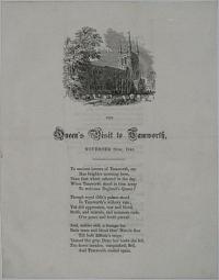
The Queen's Visit to Tamworth, November 26th, 1843. Ye ancient towers of Tamworth, say Has Brighter morning been...Type of that building which shall be From spot, defect, and blemish free, When tiem shall be no more.
Thompson, Typ. Tamworth.
Letterpress and engraving. Two sheets double-side. 216 x 171mm. 8½ x 6¾".
St. Editha's Church stands as Queen over Tamworth, dating back to the early Saxon days. It was ransacked, as was the town, and destroyed after the Danish raids of 874 and 943. A Norman church was built in its place, of which parts still stand, but that was later destroyed by a fire in 1345. Parts of the church are made up of various parts of every rebuild, so can date back to the 12th century, and every century thereafter. Drayton Manor was built for the first Robert Peel around 1790, father of Robert Peel the Prime Minister who is commemorated with a statue in the centre of Tamworth. The most important visit to Tamworth and this manor was in 1843 when Queen Victoria and Prince Albert stopped by during their tour of the Midlands. This poem encapsulates this visits and Tamworth's history.
[Ref: 16299] £95.00
(£114.00 incl.VAT)
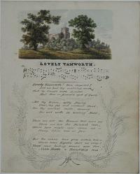
Lovely Tamworth. Lovely Tamworth! Town respected! Let me hail thy matchless worth...But the hearts that glow within thee - Where their Equals shall we view? These lasting honors win thee, - Noble Hearts to Friendship true!
[n.d. c.1850]
Pen and ink drawing, watercolour and music stave. 223 x 180mm (8¾ x 7").
Tamworth Castle, located next to the River Tame, Staffordshire. An air written with poetry.
[Ref: 16300] £140.00
(£168.00 incl.VAT)
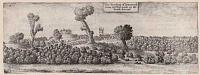
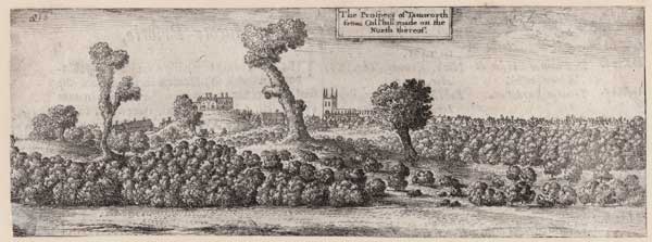
The Prospect of Tamworth from Colshill Roade on the North thereof.
[Wenceslaus Hollar.]
[n.d., c.1730.]
Etching. Sheet 65 x 185mm (2½ x 7¼"), with letterpress on reverse. Trimmed to image, laid on album paper.
A view of the town behind trees, with the church and castle. From Dugdale's 'Antiquities of Warwickshire', first published 1656. Pennington lists two editions with letterpress on verso, 1730 & 1765. Pennington 1065.
[Ref: 60813] £160.00
(£192.00 incl.VAT)
View of Taplow, taken from Maidenhead Bridge.
Drawn by W.m Havell. Engraved by R. Havell.
London, Published August 1 1818 by Thomas McLean.
Aquatint. 425 x 550mm (16¾ x 21½"). Small tear in title area, very small margins.
A view looking from Maidenhead in Berkshire up the Thames to Taplow in Buckinghamshire, painted by William Havell (1782-1857) and engraved by his cousin Robert Havell jnr. (1793-1878), famed for engraving most of Audubon's monumental 'Birds of America'. The paper around the image has been coloured to mimic board, the usual presentation of a watercolour.
[Ref: 43446] £450.00
![Tattershall Castle [ms.]](img-thumbnail/jpegs/34508.jpg)
Tattershall Castle [ms.]
T. Girtin [ms]
Etching and aquatint with hand-colouring and large margins, J. Whatman 1816 watermark; platemark 215 x 305mm (8½ x 12"). Proof, before printed text 'Tattershall Castle- Lincolnshire. / From an original drawing in the possession of Wm. Brand Esq. of Boston. Nov 1 1812'.
Plate from John Hassell's 'Aqua Pictura. Illustrated by a series of original specimens from the works of...all the most approved modern water coloured draftsmen...' (1813). This volume was an ambitious project containing fifteen plates, each in four states, to illustrate the development of a watercolour from initial drawing to completed work. This print, finished with hand-colouring, replicates the original watercolour by Thomas Girtin. Girtin had died several years previously, but had drawn Tattershall Castle as the basis for an engraving in a series of views in Lincoln, in 1799. The engraver and publisher John Hassell (1767-1825) was also a drawing master, and like several other of his books, 'Aqua Pictura' was designed for educational purposes. Abbey Life 140.10
[Ref: 34508] £160.00
(£192.00 incl.VAT)
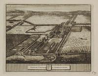
Orchard Portman in Somersetshire
[Pieter Van der Aa after Johannes Kip, 1707]
Engraving, platemark 130 x 165mm (5 x 6½"). Rare unfolded state with very large margins. Collector's stamp of Robert Johannes Meyer verso.
Orchard Portman near Taunton in Somerset. Plate from James Beverell's Les Delices de la Grande Bretagne et de L'Irlande. Formerly in the collection of Robert Johannes Meyer (1882-1976), Hamburg lawyer and print collector. L.4536
[Ref: 38506] £60.00
(£72.00 incl.VAT)
![[Top right sheet of Isaac Taylor's 'Dorset Shire'.]](img-thumbnail/jpegs/48925.jpg)
[Top right sheet of Isaac Taylor's 'Dorset Shire'.]
[Ross-on-Wye, 1765.]
Engraved map, one sheet of six. 590 x 470mm (23¼ x 18½"), very large margins. Central crease as normal. Uncut.
One sheet of the first large-scale map of Dorset. engraved by Isaac Taylor (1730-1807) from his own survey. It covers Cranborne, Blandford Forum, and Wimborne Minster in unprecedented detail, with vignettes of the 'Observatory at Horton and 'Shirborne Castle' in panels at the top. See Ref: 48926 & 48927.
[Ref: 48925] £320.00
![[Bottom right sheet of Isaac Taylor's 'Dorset Shire'.]](img-thumbnail/jpegs/48926.jpg)
[Bottom right sheet of Isaac Taylor's 'Dorset Shire'.]
[Ross-on-Wye, 1765.]
Engraved map, one sheet of six. 590 x 470mm (23¼ x 18½"), very large margins. Central crease as normal. & other central crease. Uncut.
One sheet of the first large-scale map of Dorset. engraved by Isaac Taylor (1730-1807) from his own survey. It covers Poole Harbour, Swanage, Studland, Corfe, Worth Matravers and Wareham in unprecedented detail, with the 'Characters' (key) bottom right. See: Ref 48925 & 48927
[Ref: 48926] £520.00
![[Top central sheet of Isaac Taylor's 'Dorset Shire'.]](img-thumbnail/jpegs/48927.jpg)
[Top central sheet of Isaac Taylor's 'Dorset Shire'.]
[Ross-on-Wye, 1765.]
Engraved map, one sheet of six. 590 x 470mm (23¼ x 18½"), very large margins. Central crease as normal. Uncut.
One sheet of the first large-scale map of Dorset. engraved by Isaac Taylor (1730-1807) from his own survey. It covers Shaftesbury, Sherborne, and Cerne Abbas (marking the position of the 'Giant') in unprecedented detail, with a vignette of the 'Lullworth Castle' in a panel at the top. See Ref: 48926 & 48925.
[Ref: 48927] £420.00

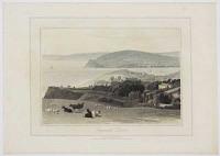
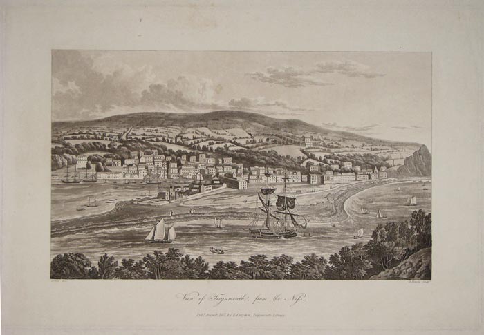
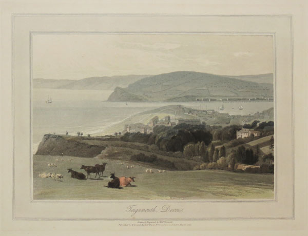
View of Teignmouth, from the Ness.
Noble del.t. D. Havell sculp.t.
Pubd. August, 1817, by E. Croydon, Teignmouth Library.
Aquatint in brown ink, 250 x 375mm (9¾ x 14¾").
Panorama of Teignmouth in Devon, on the north bank of the estuary mouth of the River Teign. Boats on the water in foreground. Plate to W.B. Noble's 'A guide to the watering-places, on the coast, between the Exe and the Dart, including Teignmouth, Dawlish, and Torquay...' See Abbey Scenery: 115.
[Ref: 11536] £140.00
(£168.00 incl.VAT)
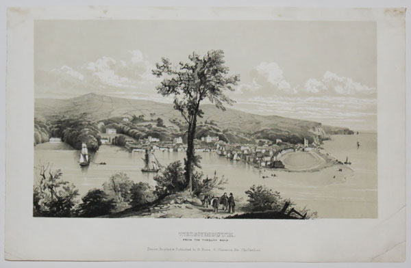
Teignmouth, From the Torquay Road.
Drawn, Printed & Published by G. Rowe: 9, Clarence Str. Cheltenham. [n.d. c.1830].
Sepia-tinted lithograph heightened in white, image 185 x 325mm. 7¼ x 12¾". Very rare.
Panoramic view of Teignmouth in Devon, on the north bank of the estuary mouth of the River Teign. Ships on the water in foreground.
[Ref: 26449] £130.00
(£156.00 incl.VAT)
Teignmouth Bridge, from the Quay. This Bridge was Designed by and Executed under the direction of Roger Hopkins, Civil Engineer, &c.&c.&c.
Strutt Delt. C. Rosenberg Sc.
Published by E. Croydon, June 5th. 1827, Public Library, Teignmouth.
Hand coloured aquatint, 265 x 360mm. 10½ x 14¼". Slightly soiled; stain to sky.
Scarce locally-published print of the first Shaldon Bridge, which crossed the estuary mouth of the River Teign at Teignmouth, Devon. Figures and cargo on quayside in foreground. The original bridge was owned by the Teignmouth and Shaldon Bridge Company and opened on 8 June 1827. It had 34 wooden arches and was 1,671 feet long, which made it the longest wooden bridge in England when built. It had abutment walls of a considerable length at either end, and a swing bridge at the Teignmouth end to allow sailing ships to pass up the estuary. It cost around £19,000 to build, but the overall expenditure was about £26,000 due to the costs of the necessary Act of Parliament and the purchase of the old ferry-rights. Toll houses were built at each end of the bridge, and the one on the Teignmouth side still survives. After only eleven years, on 27 June 1838 the centre arches of the bridge collapsed, the timbers being eaten through by shipworms. It was rebuilt in wood and reopened in 1840, but it partially collapsed again in 1893. The bridge was completely rebuilt between 1927 and 1931, using steel for the piers and main girders and concrete for most of the deck.
[Ref: 20472] £260.00
(£312.00 incl.VAT)
Teignmouth. The Den.
G. Townsend, del. Exeter.
Pub.d April 4th 1853. Pub.d by H. Besley, Directory Office, South St Exeter.
Engraving, sheet 130 x 185mm (5¼ x 7¼"). Trimmed within plate mark.
A view of the seafront park 'The Den' in Teignmouth Devon. A group of people play cricket at the heart of the green while others watch and stroll along the path.
[Ref: 56004] £65.00
(£78.00 incl.VAT)
Teignmouth, Devon.
Drawn & Engraved by Will.m Daniell.
Published by W. Daniell, Russell Place, Fitzroy Square, London. May 20, 1825.
Coloured aquatint. Plate 229 x 300mm. 9 x 11¾".
A view of Teignmouth, Devon. From William Daniell's 'A Voyage Round Great Britain', a series of 308 aquatints published in eight volumes between 1814-1825, described by R.V. Tooley as 'the most important colour plate book on British Topography'. Abbey: Scenery, 16; Tooley: Books with Coloured Plates 177.
[Ref: 24179] £120.00
(£144.00 incl.VAT)
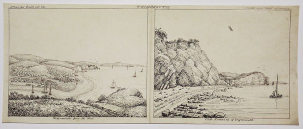
Teignmouth Teignmouth from the West. / Cliffs Eastward of Teignmouth.
W Hawkes Smith del. & fec. Printed from Stone, by WH Smith
[n.d., c.1820]
Pen and ink drawing, drawn area 185 x 430mm (7¼ x 17"). Fold through middle; unique.
Views of Teignmouth by the little-known Birmingham printmaker William Hawkes Smith (1818-1821, fl.). Ex Collection: The Late Honourable Christopher Lennox-Boyd.
[Ref: 32239] £420.00

Teignmouth, Devon.
Drawn & Engraved by Will.m Daniell.
Published by W. Daniell, Russell Place, Fitzroy Square, London May 20. 1825.
Aquatint with fine original hand colour. 230 x 300mm (9 x 12"), with large margins.
A view of coastal town of Teignmouth located on the eastuary of the River Teign. From William Daniell's 'A Voyage Round Great Britain', a series of 308 aquatints published in eight volumes between 1814-1825, described by R.V. Tooley as 'the most important colour plate book on British Topography'. Abbey: Scenery, 16; Tooley: Books with Coloured Plates 177.
[Ref: 47131] £240.00
(£288.00 incl.VAT)

Temple & Harleford.
J. Farington R.A. delt. J. C. Stadler Sculpt.
Pub. June 1, 1793, by J. & J. Boydell, Shakespeare Gallery, Pall Mall, & No. 90, Cheapside.
Sepia aquatint. 320 x 220mm.
From the 'History of the River Thames'. Abbey: 432.
[Ref: 2423] £140.00
(£168.00 incl.VAT)
Temple Newsam, the Seat of the R.t Hon.ble Arthur Lord Ingram Viscount Irwin in the West Ryding of the County of Yorke.
L. Knyff Del. J. Kip scul.
[London: Joseph Smith, c.1707.]
Engraving. 360 x 490mm (14 x 19¼"), with very large margins. Top margins messy at edges.
Temple Newsam near Leeds, a Tudor-Jacobean house with grounds landscaped by Capability Brown. Now a Grade I listed building, it is owned by Leeds Council and hosts both the 'Party in the Park' and 'Opera in the Park' annual events. From 'Britannia Illustrata'.
[Ref: 45188] £240.00
(£288.00 incl.VAT)
![[Image slip:] Tomb of the Lady Ann Grimston in the Churchyard of Tewin, Herts. [Letterpress:] The Tomb of Lady Anne Grimston, in the Churchyard of Tewin, in Hertfordshire. Dispalys one the most extraordinary and romantic of those freaks in which it is](img-thumbnail/jpegs/18178.jpg)
[Image slip:] Tomb of the Lady Ann Grimston in the Churchyard of Tewin, Herts. [Letterpress:] The Tomb of Lady Anne Grimston, in the Churchyard of Tewin, in Hertfordshire. Dispalys one the most extraordinary and romantic of those freaks in which it is proverbial that Dame Nature delights. The masonry of the tomb - once firmly set, and bound with iron pins together...however unusual, we are content to regard as beautiful illustrations of natural laws. The following inscription is still legible on the tomb: Here lyeth interred the Body of the Right Honourable Lady Anne Grimston, Wife to Sir Grimston, Bart. of Gorhambury, in Hertfordshire, Daughter to the late Right Honourable Earl of Thanet, Who departed this life Nov.22nd, 1713, In the 60th year of her age.
[On envelope:] From Anthony Knight, Bookbinder, Bookseller, Musicseller, Stationer, Printer and Engraver, Saint Andrew Streetm Hertford. [n.d. c.1840]
Scarce letterpress and engraving. Letterpress 235 x 184mm. 9¼ x 7¼". Engraving 190 x 114mm. 7½ x 4½".
Tomb of Lady Anne Grimston, St Peter's Church, Tewin, Hertfordshire. Legend has it that Lady Anne Grimston was to say the least a staunch atheist, the story goes that on her death bed she refused to allow the Vicar to administer the last rites. She went on to say that should God and the teachings of the Bible be true then seven trees would sprout from her grave, and so they did.
[Ref: 18178] £65.00
(£78.00 incl.VAT)
view all images for this item

Croquis du Cours de la Tamise par Monthellier & Tirpenne. Source of the Thames.
Lith. de Bichebois aine à S.t Denis.
A Paris Chez Tirpenne, Libraire, Editeur, rue du cloitre S.t Jaquces l'hopital, No.5. Chaillou Potrelle, Rue S.t Honoré, No. 140. Rittiueu, Boulevard Montmatre No. 12. London, Ch. Tilt, 86 Fleet Street.
A rare set of 6 lithographs with frontis. Sheet: 310 x 480mm (12 x 19"), with large margins. Foxing.
A series of vignettes over 6 plates showing views along the Thames including the Frost Fair 1814 and Oxford. Not in Abbey.
[Ref: 47863] £650.00
Thames Head.
J. Farington R.A. delt. J. C. Stadler Sculpt.
Pub. June 1, 1793, by J. & J. Boydell, Shakespeare Gallery, Pall Mall, & No. 90, Cheapside.
Sepia aquatint. 320 x 220mm.
From the 'History of the River Thames'. Abbey: 432.
[Ref: 2424] £110.00
(£132.00 incl.VAT)
![[Isle of Thanet] Mappa Thaneti Insule.](img-thumbnail/jpegs/61224.jpg)
[Isle of Thanet] Mappa Thaneti Insule.
[n.d., 1655.]
Etched map. 410 x 365mm (16 x 14½"). Splits in folds, some creasing and spotting.
A map of the isles of Thanet in the time of Augustine of Canterbury, from a manuscript map in Trinity College, Cambridge. Orientated with north to the left, it depicts the religious houses. An illustration from William Dugdale's 'Monasticon Anglicanum'.
[Ref: 61224] £160.00
The Hoo. To Gilbert Hoo Keate Esq. This Draught is humbly Presented by John Drapentier.
[Sir Henry Chauncy c.1700]
Engraving. 285 x 375mm (11¼ x 14¾"), with very large margins. Centre fold. Some damage around the centre fold towards the lower middle.
Published for the first edition of Sir Henry Chauncy's (1632 - 1719) Historical Antiquities of Hertfordshire 1700. A Grade II listed country house in Great Gaddesden, Hertfordshire. Sir Jonathan Keate, 1st Baronet (1633-1700) was a merchant who during the Interregnum imported sugar from Barbados. He retired from business after his wife inherited the Hoo estate, rebuilt the mansion there, and later acquired two adjacent manors. His son Sir Gilbert Hoo Keate, 2nd Baronet (c.1661 - 1705) later took over the estate. In 1944 the house was in use as a maternity home.
[Ref: 56220] £140.00
(£168.00 incl.VAT)
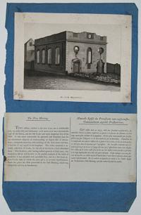
The New Meeting. The New Meeting. This edifice, erected in the year 1730, was a considerable pile; its walls lofty and substantial; in so much as to have survived the rage of the flames, and the still fiercer and more dangerous fury of the Mob... De cet endroit la populace se rendit à la Vieille Eglise des Prebytétiens (Old Meeting) qui fut ruinée de fond en comble.
Drawn by P.H. Witton Jun.r Engraved by W.m Ellis.
[London. Published, 1 May 1792, by J.Johnson, St. Paul's Church Yard.]
Aquatint with descriptive text in English and French. Sheet 406 x 260mm. 16 x 10¼". Laid on album page, foxing.
The New Meeting Chapel following its destruction during the Priestley Riots, the Birmingham Riots of 1791, which targeted religious Dissenters, most notably the politically and theologically controversial Joseph Priestley. On 14th July 1791, rioters approached the Quaker House until it was decided that the Quakers never troubled themselves with anything, and thus convinced themselves to attack the New Meeting Chapel, where Priestley presided as minister. From "Views of the Ruins of the Principal Houses destroyed during the Riots at Birmingham. 1791." On the 14th of July, 1791, a party having met at an hotel to celebrate the anniversary of the French revolution, collected together as a mob, and proceeded for several days their devastations, setting fire to several meeting-houses and private mansions, but on the arrival of the military from Oxford and Hounslow, order was restored: at the ensuing assizes four of the ring-leaders were convicted, two of whom suffered the penalty of the law. Shortly after this occurrence barracks were erected on the Vauxhall-road, near the town, consisting of a range of handsome buildings, enclosing a spacious area for the exercise of cavalry, and a smaller for parades, a riding-school, a magazine, and an hospital.
[Ref: 21105] £140.00
(£168.00 incl.VAT)
![[Theobalds.]](img-thumbnail/jpegs/44671.jpg)
[Theobalds.]
[n.d., c.1800.]
Fine watercolour. Sheet: 240 x 175mm (9½ x 7"). Glued to album sheet. Unfaded.
A watercolour of some of the buildings built in the grounds of Theobalds Palace, built by Sir William Cecil and destroyed in 1651 by Parliament. Several other buildings were built on the estate in the following centuries.
[Ref: 44671] £350.00
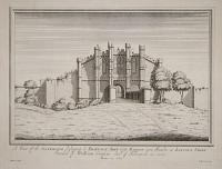
A View of the Gatehouse belonging to Thornton Abby near Barton upon Humber in Lincoln Shire Founded by William Crassus Earl of Albermarle in 1139. Drawn in 1727.
Millecent delin. E. Kirkall sculp.
[n.d., c.1745.]
Rare copper engraving, 310 x 415mm. 12¼ x 16¼". A fine impression with very large margins.
Thornton Abbey was founded as a priory in 1139 close to the small North Lincolnshire village of Thornton Curtis by William le Gros, the Earl of Yorkshire, and raised to the status of Abbey in 1148. It was a house for Augustinian or black canons. The Abbey's enormous and ornate fortified gatehouse is the largest and amongst the finest in England.
[Ref: 16364] £160.00
(£192.00 incl.VAT)

Thorp Cloud &c. This Pyramidal Mountain in Derbyshire, the River Dove washes its foot; the front (where the View was taken) is in Staffordshire at the bottom of the Gardens of Geo. Port, of Ilam Esq.r. To whom This View is Inscrib'd by his most hum.le Serv.t T. Smith.
T. Smith pinx. J. Mason Sculp.
Publish'd pursuant to an Act of Parliament Decem.r 1751 by T.Smith.
Engraving. Plate: 540 x 390mm (21¼ x 15½"), with very large margins. Tear in lower edge into plate.
A view of Thorp Cloud on the border of Staffordshire and Derbyshire at the southern end of Dovedale.
[Ref: 42782] £420.00
![[Thurrock.] London. Sheet LXXXIII.](img-thumbnail/jpegs/10973.jpg)
[Thurrock.] London. Sheet LXXXIII. Edition of 1894-96.
Photozincographed and Published by the Director General at the Ordinance Survey Office, Southampton, 1897.
Zincograph with hand colour, sheet 700 x 990mm, 27½ x 39". With stencilled sheet number and mss. notes. Laid on linen, some surface soiling, tears, edges chipped.
A large-scale plan (1/2500) of Thurrock, with part of Tilbury Docks. This sheet has been used to record the property of the Port of London Authority, noting sales. From the Port of London Authority archives.
[Ref: 10973] £60.00
![[Ticehurst House Hospital.] Chinese Gallery.](img-thumbnail/jpegs/11201.jpg)
[Ticehurst House Hospital.] Chinese Gallery. 'in Ms Newington's Pleasure Grounds.' [ink mss.]
T. Henwood del.t Westerholm Sculp.
Gad & Co. Printers London
Aquatint, 260 x 180mm (10¼ x 7"). Laid on backing sheet.
An ornamental hallway in Ticehurst House Hospital, a lavish private lunatic asylum founded by Samuel Newington (1739-1811) in 1792 for 'exceptionally wealthy' patients. The house is still a private psychiatric hospital.
[Ref: 11201] £130.00
(£156.00 incl.VAT)
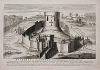
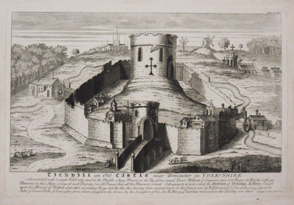
Tickhill an Old Castle near Doncaster in Yorkshire.
[Etched by George Vertue.]
Sumpt: S. Ant. Lond. 1737.
Etching. 310 x 460mm (12¼ x 18"). Very large margins.
A reconstruction of Tickhill Castle, on the borders of the Nottingham - West Riding of Yorkshire border, engraved by Vertue for the Society of Antiquaries. Outside the castle's walls are two watermills and a windmill. It was one of the last strongholds of Prince John during his usurpation of Richard I's rule in 1194; in 1372 it was given to John of Gaunt by Edward III in exchange for the Earldom of Richmond; and it was a royalist stronghold during the Civil War until it was taken by John Lilburne and razed in 1648.
[Ref: 38390] £220.00
(£264.00 incl.VAT)

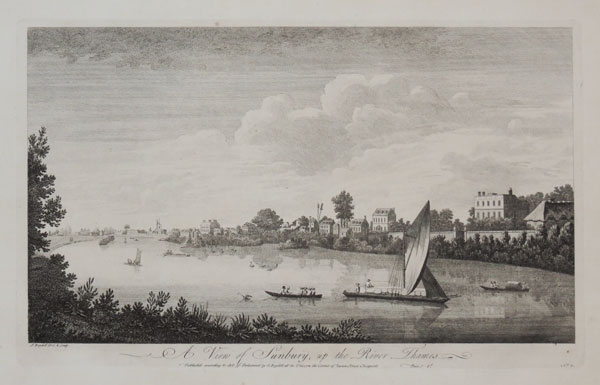
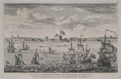
A View of Tilbury Fort, in the County of Essex.
Printed for Carington Bowles, Map & Printseller, No.69 in St. Pauls Church Yard, London. Published 2d. March, 1773.
Copper Engraving, 180 x 270mm. 7 x 10½". Tipped into album page.
Tilbury Fort is on the north, Essex, bank of the River Thames and was built to defend London from attack from the sea, particularly during the Spanish Armada and the Anglo-Dutch Wars. Numbered '8' upper right.
[Ref: 9155] £150.00
(£180.00 incl.VAT)
![[Tilbury Ness.] Essex. Sheet LXXXVIII](img-thumbnail/jpegs/10966.jpg)
[Tilbury Ness.] Essex. Sheet LXXXVIII Edition of 1894-96.
Photozincographed and Published by the Director General at the Ordnance Survey Office, Southampton, 1897.
Zincograph with hand colour, sheet 700 x 990mm, 27½ x 39". With stencilled sheet number and mss. notes. Laid on linen, some surface soiling, tears, edges chipped.
A large-scale plan (1/2500) of the Thames at Tilbury Ness, marking Northfleet Hope and Gravesend Rach, with part of Tilbury Docks. This sheet has been used to record the property of the Port of London Authority, noting sales. From the Port of London Authority archives.
[Ref: 10966] £180.00

![Sulgrave Manor [pencil]](jpegs/49228.jpg)


![[Old Sunderland.]](jpegs/51970.jpg)

![[Wearmouth Bridge] A South East View of the Cast Iron Bridge over the River Wear at Sunderland in the C.o of Durham.](jpegs/54167.jpg)


![Parlour. Swarthmore Hall. [&] The Hall. Swarthmore Hall. [&] Swarthmore Hall.](jpegs/33616.jpg)


![Tattershall Castle [ms.]](jpegs/34508.jpg)

![[Top right sheet of Isaac Taylor's 'Dorset Shire'.]](jpegs/48925.jpg)
![[Bottom right sheet of Isaac Taylor's 'Dorset Shire'.]](jpegs/48926.jpg)
![[Top central sheet of Isaac Taylor's 'Dorset Shire'.]](jpegs/48927.jpg)


![[Image slip:] Tomb of the Lady Ann Grimston in the Churchyard of Tewin, Herts. [Letterpress:] The Tomb of Lady Anne Grimston, in the Churchyard of Tewin, in Hertfordshire. Dispalys one the most extraordinary and romantic of those freaks in which it is](jpegs/18178.jpg)


![[Isle of Thanet] Mappa Thaneti Insule.](jpegs/61224.jpg)


![[Theobalds.]](jpegs/44671.jpg)


![[Thurrock.] London. Sheet LXXXIII.](jpegs/10973.jpg)
![[Ticehurst House Hospital.] Chinese Gallery.](jpegs/11201.jpg)
![[Tilbury Ness.] Essex. Sheet LXXXVIII](jpegs/10966.jpg)