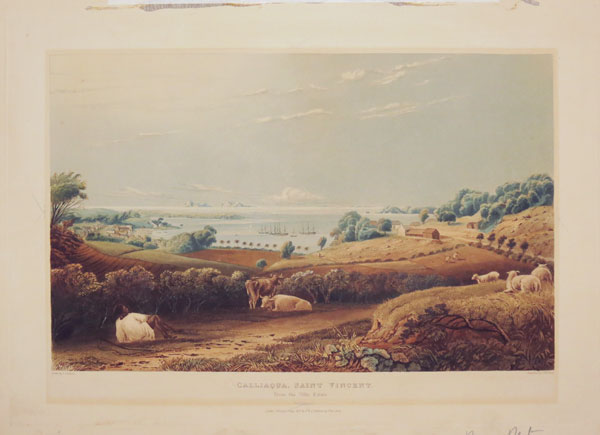
Calliaqua, Saint Vincent. From the Villa Estate.
Drawn by J. Johnson. Engraved by T. Fielding.
[n.d., c.1827].
Coloured aquatint, very fine. Plate: 490 x 350mm (19½ x 13¾"). Slighted faded.
A view from the Villa Estate, Calliaqua on the island of St. Vincent, looking out to the Caribbean Sea. Calliaqua is a town in Saint Vincent and the Grenadines. It is located in the far south of the main island of Saint Vincent, close to the island's southernmost point. ex Parker Gallery.
[Ref: 29995] £1,200.00
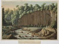
Basaltic Rocks in Washilabou or Cumberland Valley, St. Vincent.
Drawn by Lieut. Caddy, Roy.l Artill.y. Engraved by W. Westall, A.R.A.
[London. Published Feb.y 1st 1837, by Ackermann & Co., 96 Strand.]
Aquatint with fine hand colour. Sheet 215 x 280mm (8½ x 11") Trimmed around image, losing publisher's inscription.
A wall of columnar basalt rock by a river. From John Herbert Caddy's 'Scenery of the Windward and Leeward Islands', planned as a four-volume work, but only the first was published. Caddy (1801-83) was posted to the West Indies twice, to Tobago in 1828 and to St Lucia in 1833, transferring to St Vincent in 1834, the year that slavery was abolished in the British colonies. Abbey, Travel 692.
[Ref: 44738] £180.00
(£216.00 incl.VAT)

A View of Fort Charlotte_ St. Vincent.
On Stone by C. Haghe
Printed by W. Day
Lithograph on india paper, sheet 135 x 220mm (5¼ x 8½"). Toning to edges.
Fort Charlotte on the Caribbean island of St. Vincent, which stood on Berkshire Hill, Edinboro, 6000 feet above sea level. The fort was constructed between 1763 (when the British recovered the island) and 1806. The fort is now a historical site. Plate from 'Four Years' residence in the West Indies' by Frederick William N. Bayley (1808-52), who accompanied his father (a soldier) to Barbados in the 1820s. Bayley writes in his book that 'perhaps I could not have been on a more delightful spot than the citadel at Forth Charlotte'.
[Ref: 33695] £130.00
(£156.00 incl.VAT)
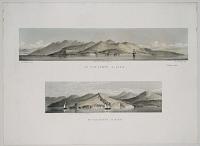
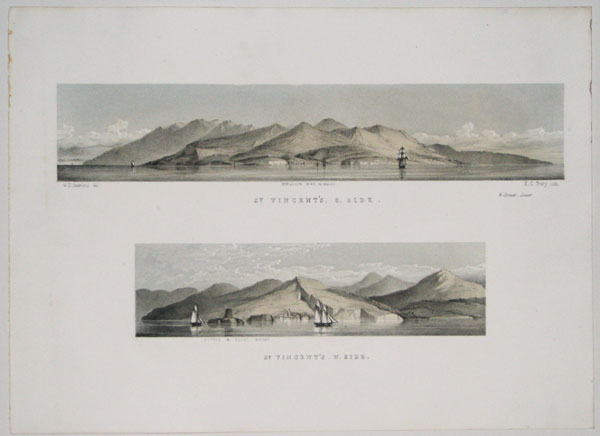
St Vincent's. S.Side. St Vincent's. W.Side.
W.S. Andrews, del. H.C. Treary, lith.
W. Spreat _ Exeter [c.1860.]
Tinted lithograph, sheet 270 x 370mm. 10½ x 14½".
Two prospects of St Vincent on one sheet, each with a ship to provide a clue to the scale. The top view is centred on Kingstown, the bottom one the Bottle and Glass rocks outside Barrouallie. From 'Andrews's Illustrations of the West Indies'. Rare: not listed in Abbey Travel.
[Ref: 17697] £320.00
![Views of Trinidad. [&] List of Subscribers. H.E. Lord Harris, Governor. V. Admiral Earl of Dundonald. R.Rd.R.P. Smith, Archbishop. M.Monaghanm bishop of Roseau. V.Rd.G.Cummens, Archdeacon. The Chieg justice Knox. Captain Goldsmith (H.M.S. Wellesley)...](img-thumbnail/jpegs/23402.jpg)
Views of Trinidad. [&] List of Subscribers. H.E. Lord Harris, Governor. V. Admiral Earl of Dundonald. R.Rd.R.P. Smith, Archbishop. M.Monaghanm bishop of Roseau. V.Rd.G.Cummens, Archdeacon. The Chieg justice Knox. Captain Goldsmith (H.M.S. Wellesley)... W.P. Paull. J. Beding Frild. H. Rey. S. Wakefield. A. Cummings, Junior.
By M.J. Cazabon.
1851.
Two pages of letterpress, frontis & listing of 149 subscribers, very scarce. 335 x 490mm. 13¼ x 19¼". [&] 350 x 507mm. 13¾ x 20". Some foxing.
Michel-Jean Cazabon (b.1813 d.1888) was the son of Martiniquan parents who settled in Trinidad in the late eighteenth century and were part of the Free Coloured/Free Black society of the Naparimas around San Fernando. Cazabon was educated first in England and then in Paris where he studied art. According to family legend Cazabon was a student of Delaroche (b.1797 d.1856). More precisely we know that he was a student of Michel-Martin Drolling (b.1789 d.1851), Jean-Antoine-Theodore Gudin (b.1802 d.1880) and Antoine Leon Morel-Fatio (b.1810 d.1871). Gudin was a marine painter and it is likely that Cazabon learnt printing from Morel-Fatio. A student in Paris from the late 1830's to about 1848, Cazabon followed closely the philosophy of the French Landscape Movement. He returned to Trinidad in 1848 and in 1851 produced a series of eighteen lithographs Views of Trinidad. In 1857 he published a second series, Album of Trinidad, and in 1860 contributed to two other series, Views of Demerara and Album Martiniquaise. Cazabon's uvre is extensive; his work shows a wide knowledge of media - oils, watercolours, gouache, gesso, etc. Although he was primarily a watercolourist and landscape artist, both his formal and informal portraits are highly valued, and his illustrations for the newspapers of the day, of important historic significance. Ex: Parker Gallery.
[Ref: 23402] £380.00
view all images for this item
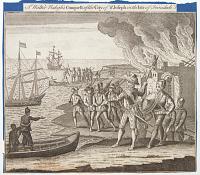
Sir Walter Raleigh's Conquest of the City of St Joseph in the Isle of Trinidad.
Engrav'd for the Universal Magazine 1750 for J. Hinton at the Kings Arms in St. Pauls Church Yard London.
Engraving. Plate: 195 x 220mm (7¾ x 8¾"). Trimmed and laid on album sheet. Some foxing towards the bottom. One vertical fold a quarter of the way from the left as normal.
St. Joseph, the capital of Spanish Trinidad, was attacked by Sir Walter Raleigh in 1595, during his expedition to find El Dorado. In the centre is the Spanish Governor, Antonio de Berrío, who was captured and interrogated for information about the location of the City of Gold. This scene was copied from Theodore De Bry's engraving in his 'Grand Voyages'.
[Ref: 52819] £120.00
(£144.00 incl.VAT)

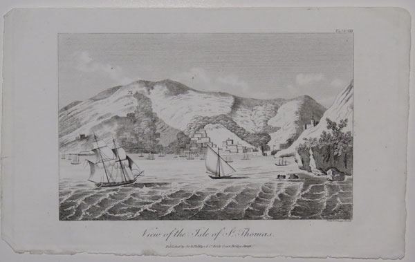
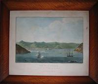
Views of the Isle of St. Thomas. Voy.s No.XXX.
Neele & Son 352 Strand.
Published by Sir R. Phillips & Co. Bridge Court, Bridge Street. [1821.]
Engraving. Plate 133 x 215mm. 5¼ x 8½".
View of Saint Thomas, in the Caribbean Sea, with a castle to the right and a fortified entrance to the port; a windmill to the left in the hills. From "A Voyage to North America, and The West Indies, in 1817. By E. Montule. Knight of the Royal Order of the Legion of Honour. Author of Travels in Egypt, &c." 1821. Saint Thomas, one of the islands that makes up the United States Virgin Islands. In 1657 the Dutch West India Company established a post there with a view to profit from the plantations and sugar cane, from which the country thrived for many years. However, by the early 19th century, Saint Thomas was in decline. The United States attempted to purchase the Island in the 1860s, but failed to find domestic legislative support for the bid; they did however succeed in 1917.
[Ref: 23846] £120.00
(£144.00 incl.VAT)
Vue De St. Thomas prise de l'Entrée de la Rade.
Peint par Brard. Grave par Hegy.
a Paris, chez l'Editeur, Quai des Augustins, No. 25 [n.d. c.1820].
Etching with coloured aquatint. Image 290 x 420mm (11½ x 16½"). Faint staining to paper, largely outside image. 2 small pieces missing from right edge of paper.
A fine copy of this rare aquatint of one of the former Danish Virgin Islands, with good hand colour. The islands were purchased by the United States in 1917.
[Ref: 906] £2,200.00

Montgomery. West Indies. Part, III.
Thomson. Del. Romney. Sc.
John Arliss, Publisher. London. [n.d. c.1860.]
Engraving. Plate 157 x 101mm. 6¼ x 4".
A dancing native. James Montgomery (1771-1854) was a British editor, hymnwriter and poet, who published his 'West Indies Collection' in 1809.
[Ref: 15552] £50.00
(£60.00 incl.VAT)
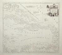
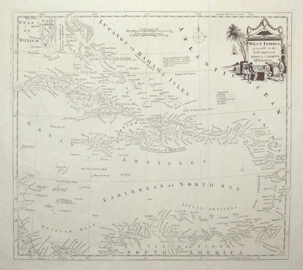
West Indies, agreeable to the most approved Maps and Charts, Mr. Kitchin.
[engraved by Thomas Kitchin.]
[London, c.1785.]
Engraved map. 350 x 385mm (13¾ x 15¼"), with very large margins. Original folds, repaired tear in left margin, some slight staining in margins, some areas weakly inked.
A map of the West Indies, with a decorative title cartouches featuring aEuropean merchants and a slave. Originally published in 'Millar's New Complete & Universal System of Geography'.
[Ref: 55318] £220.00
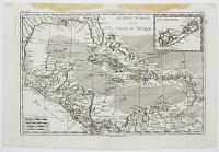
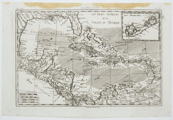
Les Isles Antilles et le Golfe du Méxique.
[by Rigobert Bonne.]
[Paris, n.d., c.1780.]
Engraved map. 225 x 330mm (9 x 13"). Small hole in margin, stain at top. Small margins.
A map of the West Indies and Gulf of Mexico, with an inset of Bermuda.
[Ref: 48929] £180.00

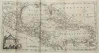
A Chart of y.e West-Indies or the Islands of America in the North Sea &c.
By H. Moll Geographer.
[n.d., 1720.]
Engraved map. 285 x 350mm (11¼ x 13¾"). Original binding folds.
A sea chart of the Gulf of Mexico and West Indies, with the eastern coast of North America north to Charleston. It still marks 'New Caledonia', the ill-fated Scottish colony on the Darien Isthmus. From Josiah Burchett's 'A Complete History of the Most Remarkable Transactions at Sea, from the Earliest Account... to the Conclusion of the Last War with France''.
[Ref: 61704] £550.00

Westindien un Guyana Marktplatz in Paramaribo [...]
[Anon., c.1850]
Engraving, platemark 270 x 315mm (10½ x 12½") very large margins.
Plate from a German travel volume with a scene of the market in Paramaribo (now the capital of Surinam) surrounded by ten vignettes including views of Martinique, Surinam and Cuba.
[Ref: 45582] £180.00
(£216.00 incl.VAT)
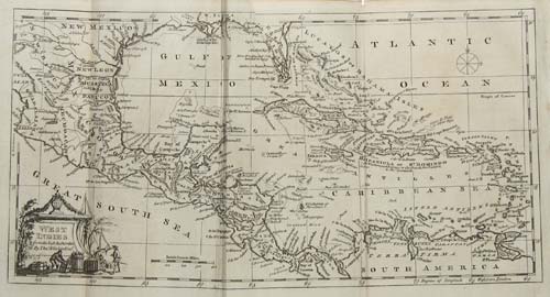
West Indies from the best Authorities
By Thos. Kitchin Geor.
[n.d. c.1784].
Engraved map. 185 x 350mm. Folded as issued in volume.
For the Modern Universal British Traveller. Thomas Kitchin [1718 - 1784] worked as a publisher and engraver from premises at The Star in Holborn, London. He produced a large number of maps of every kind for periodical, such as the London Magazine, and for books on history and antiquities. He is probably best known though, for his partnership with Emanuel Bowen with whom he published, in 1755, 'The Large English Atlas' which contained the finest county maps of the 18th.Century.
[Ref: 3587] £110.00
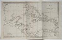
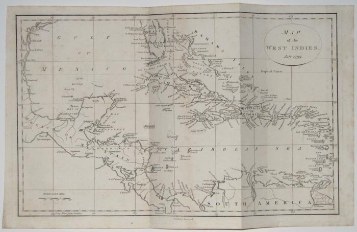
Map of the West Indies. July 1799.
[Smith & Jones.]
Copper Engraving. 260 x 400mm. 10¼ x 15¾. Two vertical folds.
A map showing Central America and the West Indies. From the British Military Library or Journal.
[Ref: 11160] £160.00
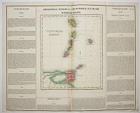
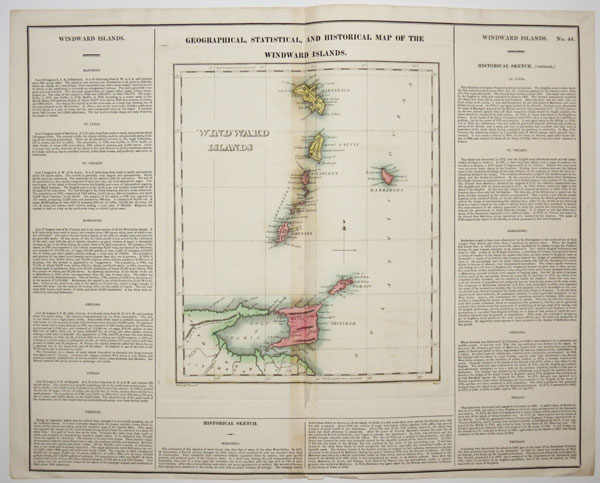
Geographical, Statisitical, and Historical Map of the Windward Islands.
Drawn by F. Lucas J.r. Boyd sc.
[n.d., c.1825.]
Engraved map with letterpress. Sheet: 445 x 550mm (17½ x 21¾"). Central fold as issued and tear along fold.
A map of the Windward Islands including Martinique to Trinidad and Tobago, each island has a letterpress description. From Carey & Lea's American Atlas.
[Ref: 47074] £140.00
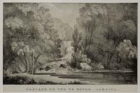
Cascade on the Ys River. Jamaica.
[n.d., c.1830.]
Very scarce & rare lithograph. Sheet: 160 x 105mm, (6¼ x 4¼"). Trimmed to printed area.
A view of the series of eight waterfalls on the YS river in Jamaica. The YS river was named after the area's original landowners John Yates and Richard Scott.
[Ref: 39473] £85.00
(£102.00 incl.VAT)


![Views of Trinidad. [&] List of Subscribers. H.E. Lord Harris, Governor. V. Admiral Earl of Dundonald. R.Rd.R.P. Smith, Archbishop. M.Monaghanm bishop of Roseau. V.Rd.G.Cummens, Archdeacon. The Chieg justice Knox. Captain Goldsmith (H.M.S. Wellesley)...](jpegs/23402.jpg)