Catalogue: England
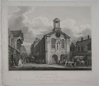
![The Late Dr. White's House, King St. [Manchester.]](img-thumbnail/jpegs/23684.jpg)
The Late Dr. White's House, King St. [Manchester.]
I. Ralston delt. & on Stone by A. Aglio. Printed by N. Chater & Co.
Published by D. & P. Jackson, Manchester, Septr. 1823.
Lithograph on india, india 310 x 390mm. 12¼ x 15¼". Very slight creases on india.
In 1752 Charles White (1696 - 1776), along with Joseph Bancroft, a merchant, was instrumental in founding Manchester Infirmary. This was the first hospital in the area. The premises were a house in Garden Street but a new, purpose-built, hospital was opened overlooking what is now Piccadilly Gardens in 1756. White was a surgeon at the infirmary for 28 years. Atmospheric street scene. After John Ralston (1789 - 1833) a little known Manchester-based artist. Some of the best pictorial records of late 18th and early 19th century Manchester rely on drawings made by Ralston, including his many studies of Market Sted Lane (now Market Street). Wellcome Library no. 571883i.
[Ref: 23684] £180.00
(£216.00 incl.VAT)
![[Manchester Royal Infirmary, Piccadilly Gardens]](img-thumbnail/jpegs/61287.jpg)
[Manchester Royal Infirmary, Piccadilly Gardens]
Fred. W. Goolden inv. et del. [pencil signature]. Fred. W. Goolden 09.
Published 1909 by Tho.s Agnew & Sons, London & Manchester.
Fine etching, signed by the artist. 295 x 450mm (11½ x 71¾").
With a remarque of St George and the Dragon.
[Ref: 61287] £240.00
(£288.00 incl.VAT)

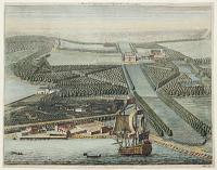
Reasons in Favour of the Bill, For making and maintaining a Turnpike Road, from or near the Town of Manchester, in the County of Lancaster, to Hyde-lane Bridge, in the County of Chester. [with map] Plan of an Intended Turnpike Road from near Manchester to Hyde Lane Bridge.
Sharpe, Eccles & Cririe, Solicitors. Dorington Agent.
Printed by J. Aston, at the Exchange-Heral-Office, St Ann's Street, Manchester. [n.d., c.1822.]
Pamphlet, single sheet of letterpress, 390 x 320mm (15½ x 12½") folded, folding map with original colour stitched in. Map 250 x 270mm (9¾ x 10½") Contemporary ink on cover, map with ink offset.
A plan to build a more direct road from Manchester to Hyde, where there were 40 cotton mills in operation. Hyde is now part of Greater Manchester. The style of the map suggests it was engraved by John Cary.
[Ref: 44733] £80.00
view all images for this item
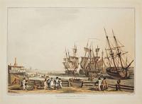
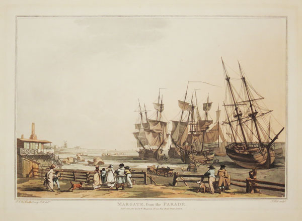
![Margate, with the Arrival of the Hoy. [&] Margate, from the Parade.](img-thumbnail/jpegs/20598.jpg)
Margate, with the Arrival of the Hoy. [&] Margate, from the Parade.
P.J. De Loutherbourg R.A. delt. J.C. Stadler Sculpt.
London: Published by R. Bowyer, Historic Gallery, Pall-Mall, 1801.
Pair of hand-coloured aquatints with etching, each c.440 x 580mm. 17¼ x 22¾". Slightly faded; with margins. Laid on board.
Two impressive views of figures and shipping on the seafront at Margate, Kent. From a first edition of 'Picturesque Scenery of Great Britain' after designs by the landscape painter and scene designer Philip James de Loutherbourg (1740 - 1812). Abbey Scenery 6, 3 & 4. First Issue.
[Ref: 20598] £700.00
view all images for this item
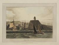
![[Original sketch for Dugdales' England & Wales.] [Margate]](img-thumbnail/jpegs/60274.jpg)
[Original sketch for Dugdales' England & Wales.] [Margate]
[Thomas Hosmer Shepherd]
[n.d., c.1838.]
Colour wash sketch. Sheet 85 x 135mm (3¼ x 5¼"). Mounted on album paper at corners.
Margate Pier with a paddle steamer. This is the original sketch for the engraving published in ''Curiosities of Great Britain: England and Wales Delineated'', by Thomas Dugdale, published by John Tallis in parts from 1838.
[Ref: 60274] £250.00
(£300.00 incl.VAT)
Margate, from the Parade.
P.J. De Loutherbourg R.A. del.t. J. Hill sculp.t.
Pub.d Oct.r 1, 1809 by I. & W. Macgavin, No. 107 New Bond Street, London.
Fine coloured aquatint, 390 x 550mm (15¼ x 21¾"), on paper watermarked 'J. Whatman 1808', with wide margins.
The harbour of Margate, Kent, from Philip James De Loutherbourg's great work 'Picturesque Scenery of Great Britain'. This series of six large aquatints had been originally published by Bowyer in 1801, with plates etched by J.C. Stadler; for this second edition the plates were re-engraved by John Hill, with only slight differences. The German-born painter had already made his name in Paris before moving to London in 1771, where he became the principal scenery designer for Garrick at London's Drury Lane Theatre. Also in the theatre, he invented the 'Eidophusikon', a moving panorama enhanced with mirrors, displayed with accompanying music. Abbey: Scenery 6.
[Ref: 30784] £520.00
![[Clock Tower, St Albans.]](img-thumbnail/jpegs/50409.jpg)
[Clock Tower, St Albans.]
Drawn and Etched by J. Schnebbelie 1786.
London Pub.d March 1st. 1787 by F. Jukes No.3 Howland St.
Rare etching, proof. Plate: 250 x 320mm (9¾ x 12½'').
A view of the clock tower in St Albans. One of a series of four etchings of the market town by Jacob Schebbelie (1760-1792).
[Ref: 50409] £160.00
(£192.00 incl.VAT)
![[Marston Trussell] The Hall Gates [pencil on rear of mount]](img-thumbnail/jpegs/49395.jpg)
[Marston Trussell] The Hall Gates [pencil on rear of mount]
[Illegible pencil signature.]
[n.d., c.1930.]
Etching, signed by the artist. 165 x 215mm (6½ x 8½").
The late 17th century wrought-iron carriage gates of Marston Trussell Hall, originally made for the house of Erasmus Norwich at Brampton Ash but moved in the mid-1700s.
[Ref: 49395] £65.00
(£78.00 incl.VAT)

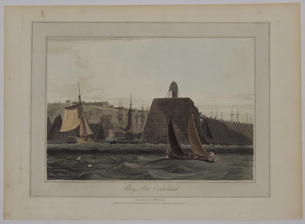
Mary Port, Cumberland.
Drawn & Engraved by Will.m Daniell.
Published by Messrs. Longman & Co., Paternoster Row & W.Daniell, 9 Cleveland Street, Fitzroy Square, London, May 1, 1816.
Hand coloured aquatint with large margins. Platemark: 230 x 290mm (9 x 11¼").
A scene depicting a ship approaching the entrance of the harbour at Maryport, Cumberland, with others seen inside. Two figures are sailing in a small boat in the foreground at the right with buildings on a plateau in the background at left. Plate 48 From William Daniell's 'A Voyage Round Great Britain', a series of 308 aquatints published in eight volumes between 1814-1825, described by R.V. Tooley as 'the most important colour plate book on British Topography'. William Daniell's 'A Voyage Round Great Britain' was the most ambitious of the many topographical publications produced in England during the early nineteenth century and its plates are a highpoint in the history of aquatint engraving. Abbey: Scenery, 16; Tooley: Books with Coloured Plates 177.
[Ref: 33886] £120.00
(£144.00 incl.VAT)
Mary Port, Cumberland.
Drawn & Engraved by Will.m Daniell.
Published by Mess.rs Longman, & Co. Paternoster Row, & W. Daniell, 9 Cleveland St. Fitzroy Square, London. May, 1, 1816.
Aquatint with fine original hand colour. 230 x 300mm (9 x 12"). Large margins, uncut.
A ship approaching the entrance of the harbour at Maryport, with others seen inside. Two figures are seen sailing in a small boat in the foreground to the right. From William Daniell's 'A Voyage Round Great Britain', a series of 308 aquatints published in eight volumes between 1814-1825, described by R.V. Tooley as 'the most important colour plate book on British Topography'. Abbey: Scenery, 16; Tooley: Books with Coloured Plates 177.
[Ref: 36121] £160.00
(£192.00 incl.VAT)

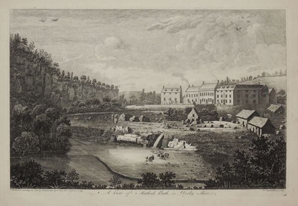
A View of Matlock Bath, in Derby Shire. [58 in ink]
J.no Boydell Del. & Sculp.
Publish'd according to Act of Parliament by J. Boydell Engraver 1749.
Engraving, paper watermarked with very large margins. Plate 305 x 456mm (12 x 18").
A view of the village of Matlock Bath, Derbyshire; built along the River Derwent. In 1698 warm springs were discovered and a Bath House was built. From "A Collection of One Hundred Views In England and Wales". John Boydell's 'Collection of Views' was made after he turned from engraver to print publisher in 1767. The first collection was issued in 1770, and included some plates by printmakers other than himself.
[Ref: 29385] £300.00
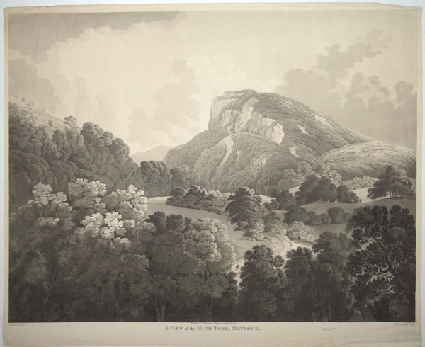
A View of the High Torr, Matlock. Plate 1.st.
I. Brewer [John James Brewer] pinx. T. Cartwright sculp.
Published by R. Moseley & I. Brewer, Derby, Nov. r. 1, 1808.
Extremely rare aquatint. 645 x 510mm (25½ x 20"), on Whatman paper. Some creasing in margins.
View of the High Tor near Matlock in Derbyshire.
[Ref: 52192] £320.00
A View of that Beautiful Cascade, near Matlock-Bath in Derby-Shire.
Printed for Rob.t Sayer Map & Printseller. No.53 in Fleet Street, London. [n.d. c.1760.]
Engraving with very large margins. Plate 179 x 280mm (7 x 11"). Crease to lower left corner.
Waterfalls near the village of Matlock Bath, Derbyshire; along the River Derwent. Figures stand on both sides of the river, one man to the right fishing.
[Ref: 30369] £120.00
(£144.00 incl.VAT)
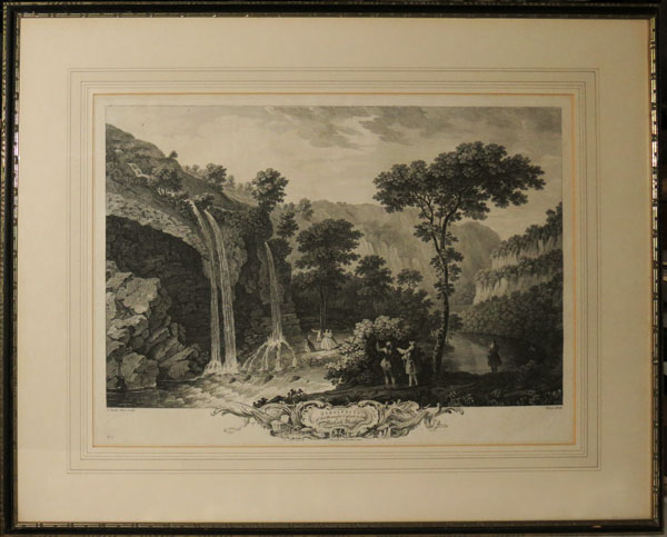
A Prospect of the Beautiful Cascade below Matlock Bath.
T. Smith Pinx. et del. Vivares Sculp.
J. Boydell excu.t. London, 1769.
Very fine engraving. Framed. Plate: 540 x 390mm (21¼ x 15¼"). Frame: 780 x 620mm (30¾ x 24½"). Large margins. Unexamined out of frame.
A view of the waterfalls at the spa of Matlock Bath in Derbyshire. In 1698 the warm springs were discovered and a bath house was built, and throughout the eighteenth and nineteenth centuries the area became very popular as a tourist destination. Originally published in 1743. For a smaller version printed by R. Sayer see ref: 30369.
[Ref: 38742] £420.00
A Prospect of the Beautiful Cascade below Matlock Bath. No. 5.
T. Smith Pinx. et del. Vivares Sculp.
Published March 25.th 1743.
Engraving. 540 x 390mm (21¼ x 15¼"), large margins. Repaired tears mainly in sky.
A view of the waterfalls at the spa of Matlock Bath in Derbyshire. In 1698 the warm springs were discovered and a bath house was built, and throughout the eighteenth and nineteenth centuries the area became very popular as a tourist destination. From the series 'Eight of the most extraordinary Prospects in the Mountainous Parts of Derbyshire and Staffordshire commonly called the Peak and Moorlands', by Thomas Smith of Derby (d.1767), father of John Raphael Smith.
[Ref: 60386] £320.00

A View of Matlock Bath, &c. from the Lovers Walk; in Derby-Shire.
Printed for Rob.t Sayer Map & Printseller. No.53 in Fleet Street, London. [n.d. c.1760.]
Engraving, paper watermarked. 170 x 265mm (6¾ x 10½"). Trimmed.
The Lovers' Walks are a series of footpaths both along the riverside and up and over the precipitous and spectacular cliffs. The village of Matlock Bath seen across the River Derwent.
[Ref: 30375] £90.00
(£108.00 incl.VAT)

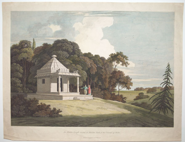
An Hindoo Temple erected in Melchet Park, in the County of Wilts.
Drawn & Engraved by W.m Daniell.
[n.d. c.1802.]
Extremely rare hand-coloured aquatint. 356 x 464mm (14 x 18¼"). Some creasing.
View of an Indian temple at left, built on a hill, surrounded by trees and shrubs on three sides, with an elegantly dressed man and woman standing near the porch, the man pointing at the building.
[Ref: 52448] £1,250.00
[To Sam.l Oldknow Esqr. _The Proprietor, This West View of Mellor Mill in Derbyshire is with the greatest respect, inscribed by his obedient H.ble Servants, F.Jukes & V.Zanetti.]
[From an original Picture by J.Parry. Engraved by F.Jukes.]
[Published July 12th 1803 by Francis Jukes, No. 10 Howland Street _ And Vittore Zanetti, Repository of Arts, Manchester.]
Aquatint with very fine original hand colour, very large margins, proof before all letters 370 x 480mm (14½ x 18¾"), on paper watermarked 'J Ruse'. Several tears in margin, one just entering plate at bottom. Slight time staining.
Mellor Mill, a six-story cotton mill in Marple (now Greater Manchester), built by Samuel Oldknow 1793-5. Extremely rare & fine image. Oldknow (1756-1828) was a cotton manufacturer at the forefront of the Industrial Revolution. Early in his career he used the 'putting-out' system of production, distributing raw cotton to spinners and yarn to weavers who worked in their own homes and workshops. This could not compete against the Indian muslin trade, so he secured money to built this factory. A financial crisis caused by the French Revolutionary Wars put him on the brink of bankrupcy, but he was saved by a partnership with Richard Arkwright. By the time this print was published the mill had over 500 employees, including a number of parish apprentices who were brought up from London. He was known as a good employer: his farming interests allowed him to supply his workers with food and he built them housing. He also introduced his own system of paper money to pay his workforce which could be exchanged for goods at the village shop or for cash via third parties. However by the time of his death he was £206,000 in debt. Oldknow also invested in the Peak Forest Canal, on which was the Marple Aqueduct, which was also the subject of an aquatint by Joseph Parry and Francis Jukes. See Ref: 35461
[Ref: 56183] £620.00

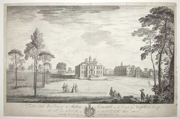
The South West View of Melton Constable in the County of Norfolk, the Seat of S.r Jacob Astley, Bart:t, is humbly Inscrib'd by His Oblig'd Serv:ts Sam:l & Nath:l Buck.
Sam.l & Nath.l Buck delin. et sculp.t August 1741. No I Garden Court Middle Temple.
Scarce engraving. 380 x 600mm (15 x 23½"), large margins. Repairs to margins.
Melton Constable Hall, built 1664-70, now grade 1 listed. The Park was landscaped by Capability Brown in 1764-9.
[Ref: 58724] £480.00
(£576.00 incl.VAT)

The South West View of Melton Constable in the County of Norfolk, the Seat of S.r Jacob Astley, Bart:t, is humbly Inscrib'd by His Oblig'd Serv:ts Sam:l & Nath:l Buck.
Sam.l & Nath.l Buck delin. et sculp.t August 1741. No I Garden Court Middle Temple.
Scarce engraving, 18th century watermark. 380 x 600mm (15 x 23½"). Trimmed to plate, creases, tears repaired.
Melton Constable Hall, built 1664-70, now grade 1 listed. The Park was landscaped by Capability Brown in 1764-9.
[Ref: 59339] £280.00
(£336.00 incl.VAT)
![[Memorial Theatre, Stratford-on-Avon.] 25.](img-thumbnail/jpegs/14613.jpg)
[Memorial Theatre, Stratford-on-Avon.] 25. [The original Shakespeare memorial, consisting of a theatre, picture gallery and library, built in 1877, was largely destroyed by fire in 1926. At the request of the governors, the Royal Institute of British Architects instituted a competition to open to architects in the British Isles, Canada and the United States of America. The plan chosen was that of Miss Elizabeth Scott, and the new building was opened in April, 1932. It is a brick building of bolds, rather severe, outlings, standing in an unrivalled position on the bank of the Avon. The shell of the old theatre was converted into a fine Conference Hall seating between four and five hundred persons. The theatre is elaborately equipped to ensure the same continuity of scenes as the plays had in Shakespeare's day. Every year the theatre presents a festival of plays both by Shakespeare and other playwrights.]
Arthur Spencer [pencil signature to the bottom left-hand side outside the image]
[n.d. c.1920.] Copyright. F. & M. Ltd., Bedford, Eng.
Etching. 257 x 280mm. 10 x 11".
[Ref: 14613] £60.00
(£72.00 incl.VAT)

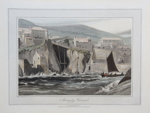
Mevagissy, Cornwall.
Drawn & Engraved by Will.m Daniell.
Published by W. Daniell, Russell Place, Fitzroy Square, London May 20. 1825.
Aquatint with hand colour.Plate: 230 x 300mm (9 x 12") large margins. On card as usual
A view of the town of Mevagissey. From William Daniell's 'A Voyage Round Great Britain', a series of 308 aquatints published in eight volumes between 1814-1825, described by R.V. Tooley as 'the most important colour plate book on British Topography'. Abbey: Scenery, 16; Tooley: Books with Coloured Plates 177.
[Ref: 47279] £180.00
(£216.00 incl.VAT)
![Mickleham Church. [pencil.]](img-thumbnail/jpegs/11662.jpg)
Mickleham Church. [pencil.]
Walter G. Price. [pencil signature.]
[n.d., c.1920.]
Etching, signed by the artist. 125 x 90mm, 5 x 3½".
St Michel's Church, Mickleham, between Leatherhead and Dorking, Surrey. Price was born in Birmingham, His etchings were exhibited between 1910-1933, including one at the R.A.
[Ref: 11662] £60.00
(£72.00 incl.VAT)
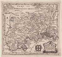
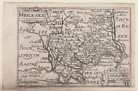
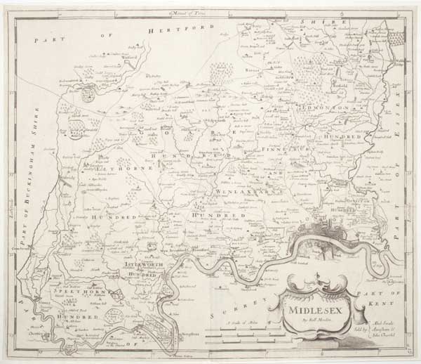
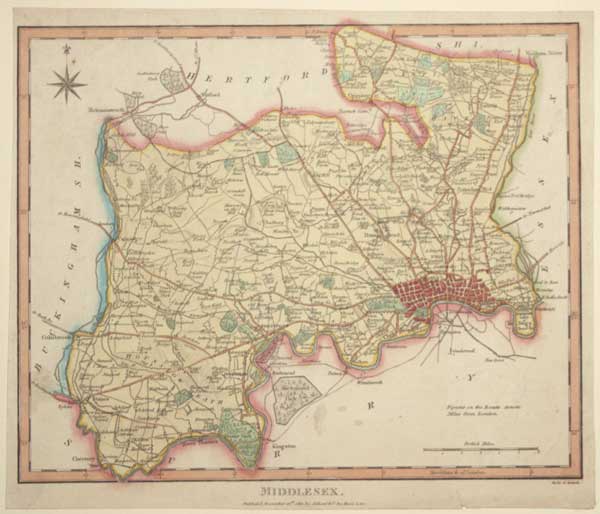
Midlesex.
[London, Awnsham Churchill, 1722.]
Engraved map. Sheet 370 x 430mm (14½ x 17"). Trimmed to plate, laid on album sheet.
A map of Middlesex, based on John Speed but with John Ogilby's roads added. First published in 'Camdens Britannia' in 1695, this example comes from 'Britannia: Or A Chorographical Description Of Great Britain'
[Ref: 61746] £240.00

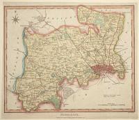
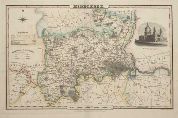
Middlesex.
Engraved on Steel by Pigot & Son, Manchester.
Published by Pigot & C.º 24 Basing Lane, London, & Fountain S.t Manchester [n.d., 1829].
Engraved map with hand colour. 235 x 370mm (9¼ x 14½"), with very large margins. Tear near centre fold, mounted on card at corners.
A detailed map of Middlesex, marking the road layout on London, with a vignette of St Paul's Cathedral. From the first edition of 'Pigot & Cos British Atlas of the Counties of England', the first county atlas with steel-engraved maps.
[Ref: 61748] £260.00
Middlesex. Drawn from Surveys & most approved Maps By Eman: Bowen Geograph.r to His Majesty.
Printed for J. Hinton at the Kings Arms in Newgae Street 1752.
Engraved map. 190 x 205mm (7½ x 8"). Mounted on album paper.
A small-format map of Middlesex, with the streets of London shown, decorated with an ornate baroque title cartouche and the arms of the City of London. From 'The Universal Magazine of Knowledge and Pleasure'; because it was not published in an atlas the map is uncommon.
[Ref: 61726] £180.00
Middlesex.
Neel et Stand.
Publish'd November 21dt 1811 by Adlard & C.º Ave Maria Lane.
Engraved map with hand colour. Sheet 205 x 240mm (8 x 9½"). Trimmed within plate, mounted on album paper.
A small-format map of Middlesex, with the streets of London shown, published in the 'Encyclopaedia Londinensis' by John Wilkes.
[Ref: 61727] £140.00
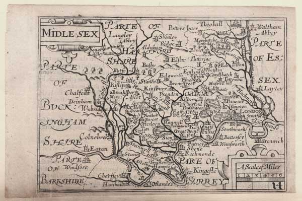
Midle-Sex.
[engraved by Pieter van den Keere.]
[London: George Humble, c.1627.]
Engraved map. 90 x 120mm (3½ x 4¾"). Trimmed within plate at bottom, a little surface soiling at bottom edge, mounted on album paper on left. Very small tear bottom centre.
A miniature map of Middlesex, engraved by Pieter van den Keere sometime after 1599 but first published in a county atlas by Willem Blaeu in 1617. In 1627 the maps were published with English titles engraved instead of the Latin ones, in a miniature atlas, ''England Wales Scotland and Ireland Described and Abridged With ye Historie Relation of things worthy memory''. Although the maps were engraved before John Speed's atlas, the maps gained the nickname 'miniature Speeds' because Humble (son of Speed's original publisher) used an abridged version of Speed's text for the miniature atlas.
[Ref: 61723] £160.00

Middlesex Hertforshire, Bedfordshire and Buckinghamshire. Railways. 2.
[James Reynolds, London 1863]
Hand coloured engraving, sheet 240 x 185mm (9½ x 7¼"). Folded as issued, time staining along taped fold.
From 'Reynolds's Geological Atlas of Great Britain'. A map of the railways showing ones under constuction and stations.
[Ref: 56920] £40.00
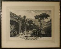
![[Middleton Dale, Derbyshire][in pencil]](img-thumbnail/jpegs/56566.jpg)
[Middleton Dale, Derbyshire][in pencil]
Rare & scarce coloured lithograph, sheet 345 x 445mm (13½ x 14½"). Trimmed and glued to backing card as issued.
A view of a village, Stoney Middleton, in the limestone valley Middleton Dale located in the Peak Distrtict. It features a building named 'The Lovers Leap' built after the incident in 1762 where Hannah Baddeley jilted by her lover, William Barnsley, attempted to commit suicide by jumping from the cliff tops and was miraculously saved by her voluminous skirts billowing out and acting like a parachute. The building is now a restaurant.
[Ref: 56566] £230.00
(£276.00 incl.VAT)

Smelting House, in Middleton Dale, Derbyshire.
Drawn by F.L. Chantrey, A.R.A. Engraved by W.B. Cooke
Published by J. Murray, March 1st 1818
Etching on india, sheet 295 x 225mm (11½ x 8¾").
Industrial landscape after a drawing by the sculptor Sir Francis Leggatt Chantrey (1781-1841), who grew up near Sheffield, not far from the location depicted here.
[Ref: 43691] £65.00
(£78.00 incl.VAT)
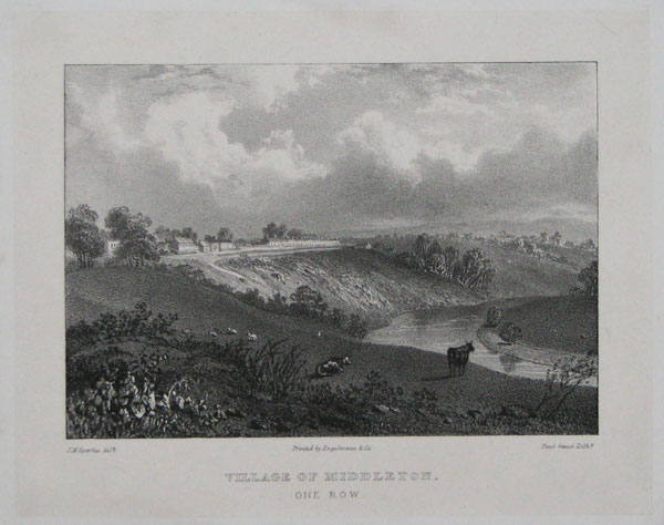
Village of Middleton. One Row.
J.M. Sparks delt. Paul Gauci lith.
Printed by Engelmann & Co. [n.d. c.1820.]
Lithograph. 159 x 197mm. 6¼ x 7¾". Glue residue in the margins.
Middleton One Row, a village in the borough of Darlington, County Durham. Situated to the east of Darlington and north of the River Tees; this village consists of a single row of houses on the north side of the village green, giving the village its name. Not in Abbey.
[Ref: 16408] £65.00
(£78.00 incl.VAT)
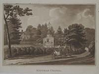
Midgham Chapel.
[Drawn & Engraved by Cha.s Tomkins.]
[London: Printed by J. Whiting, Finsbury Place, For J. Manson, Gerrard Street, Soho; and sold by Messrs. White, Fleet Street; T. Payne, Mews Gate; Greenland and Norris, Finsbury Square; H.D. Symonds, Paternoster Row; by the principal Booksellers in Berkshire and the adjoining Counties 1805.]
Aquatint. 210 x 280mm. 8¼ x 11". Paper toning. Spotting.
This chapel at Midgham, Berkshire, was built c.1309, and stood near Midgham House, showing a coach in front. Abbey: 292: 40.
[Ref: 17868] £70.00
(£84.00 incl.VAT)
![From the Book-room at the Villetta [two different versions of same view, with double portrait of Henri IV and Maria de Medicis]](img-thumbnail/jpegs/35680.jpg)
From the Book-room at the Villetta [two different versions of same view, with double portrait of Henri IV and Maria de Medicis]
M.A.T. Whitby . 1826.
Two transfer lithographs and one etching, lithograph sheets approx 115 x 180mm (4½ x 7"), etching 65 x 50mm (2½ x 2"). Each glued to backing sheet. Portrait trimmed to image in oval shape.
Two views near Milford on Sea, Hampshire, looking towards the needles, taken from Newlands, the estate the naval officer Sir William Cornwallis bought in 1799. The printmaker, Mary Anne Theresa Whitby (1784-1850), was married to Captain John Whitby, flag captain for Admiral Sir William Cornwallis. They lived on the admiral's estate, Newlands: after John's death in 1806, Mary stayed on, spending much of her time with Cornwallis, who left his estate to her on his death in 1819. Being a keen amateur lithographer, Whitby established a private press at Newlands, but she is better remembered for the first successful sericulture (silk production) to England after three centuries of attempts, presenting twenty yards of damask to Queen Victoria in 1844. She performed genetic experiments on her silkworms for Charles Darwin, who published her results in his 'The Variation of Animals and Plants Under Domestication' (1868). With a very late and worn double portrait of Henri IV and Msrie de Médicis by Simon van de Passe (etched c.1625, from a medal). For a London view by Whitby, see ref. 19290.
[Ref: 35680] £130.00
(£156.00 incl.VAT)
view all images for this item
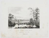
The Needles & Milford Church from the Oval Room. Newlands.
M.A.T.W. [Mary Anne Theresa Whitby] 1830.
Rare lithograph. Printed area 140 x 160mm (5½ x 6¼"), with wide margins. Foxing, mostly in title area.
View near Milford on Sea, Hampshire, looking towards the needles, taken from Newlands, the estate that the naval officer Sir William Cornwallis bought in 1799. The printmaker, Mary Anne Theresa Whitby (1784-1850), was married to Captain John Whitby, flag captain for Admiral Sir William Cornwallis. They lived on the admiral's estate, Newlands: after John's death in 1806, Mary stayed on, spending much of her time with Cornwallis, who left his estate to her on his death in 1819. Being a keen amateur lithographer, Whitby established a private press at Newlands, but she is better remembered for the first successful sericulture (silk production) to England after three centuries of attempts, presenting twenty yards of damask to Queen Victoria in 1844. She performed genetic experiments on her silkworms for Charles Darwin, who published her results in his 'The Variation of Animals and Plants Under Domestication' (1868). Ex: Collection of the late Hon. C. Lennox-Boyd; For a London view by Whitby, see ref. 19290.
[Ref: 35699] £130.00
(£156.00 incl.VAT)

A Mill.
Painted by John Constable R.A. Engraved by David Lucas.
London, Published by M.r Constable, 35 Charlotte S.t Fitzroy Square 1830.
Mezzotint. Plate: 180 x 255mm (7 x 10"), with very large margins. Slight foxing.
A view of a watermill. From about 1829 Constable and Lucas worked together on a series of mezzotints after sketches and paintings by Constable called 'Various Subjects of Landscape...' published in parts between 1830 and 1832. In 1843 Charles Robert Leslie published his 'Memoirs of John Constable Esq. R.A'. He obtained directly from the Constable family 186 sets of 22 images of the Various Subjects of Landscape in return for 30 copies of his book. This mezzotint is one of those; "see Tate John Constable, David Lucas". Wedmore 17. Shirley: 5. Osbert Barnard: I of V.
[Ref: 44384] £230.00
(£276.00 incl.VAT)
Select Views in the Isle of Wight, & its Environs. Plate 2nd, View of Mirables with Mr Arnold's Cottage, at the back of the Island.
Walmsley pinx.t. Hassell sculp.t.
London, Published June 24th, 1801 by James Daniell & C.o, No 480 Strand.
Aquatint, printed in colours and hand-finished, J. Whatman 1801 watermark. 550 x 715mm (21¾ x 28¼"). Trimmed to plate, repairs to edges.
A large view of Mirables, a Grade II listed house on the Undercliff at Niton, Isle of Wight, before it was enlarged in the 1860s.
[Ref: 57966] £450.00
South-West View of the Parish Church of Mistley in Essex.
R.t Adam Architect 1776. Tho.s Vivares incidit.
Published as the Act directs 1779.
Engraving. 440 x 580mm (17¼ x 22¾"). Printer's crease in top margin just entering image.
In 1776 Robert Adam was commissioned to redesign the Church of St. Mary the Virgin at Mistley in neoclassical style. He built towers at the east and the west ends and an entrance portico in the centre. Although most of the church was demolished in 1870 the towers remain; known as the Mistley Towers, they are Grade I listed. Published in Adam's 'Works on Architecture'.
[Ref: 47709] £280.00
(£336.00 incl.VAT)

Mistley near Harwich, Essex.
Drawn & Engraved by Will.m Daniell.
Published by W. Daniell, Cleveland Street, Fitzroy Square, London, July 1, 1822.
Aquatint with fine original hand colour. 230 x 300mm (9 x 12"), with large margins.
A view of the harbour at Mistley. From William Daniell's 'A Voyage Round Great Britain', a series of 308 aquatints published in eight volumes between 1814-1825, described by R.V. Tooley as 'the most important colour plate book on British Topography'. Abbey: Scenery, 16; Tooley: Books with Coloured Plates 177.
[Ref: 47156] £220.00
(£264.00 incl.VAT)

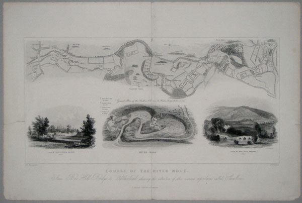
Course of the River Mole, From Box Hill Bridge to Leatherhead, shewing the situationof the various apertures called Swallows.
J.R. Thompson. J.Archer sc. N.Whittock.
[n.d., c.1850.]
Wood engraving. Printed area 220 x 390mm, 8½ x 15¼". Split in lower centre fold, tear just entering printed area, both taped.
A map of the River Mole from Leatherhead to Dorking, with three vignettes.
[Ref: 13163] £80.00
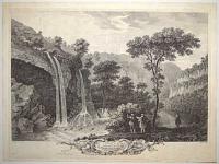
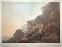
![[Monsal Dale][in pencil]](img-thumbnail/jpegs/56567.jpg)
[Monsal Dale][in pencil]
Rare lithograph, sheet 345 x 445mm (13½ x 14½"). Trimmed and glued to backing card, as issued.
A view of Monsal Dale in the White Peak limestone area of the Peak District. A man fishes on the river Wye opposite a small cluster of buildings where people walk and a man herds his flock of sheep. A small makeshift bridge joins the two sides of the river and another man fishes upstream all surrounded by the beautiful rolling hills of the Peak District. See: Ref: 56569 & 56570
[Ref: 56567] £230.00
(£276.00 incl.VAT)
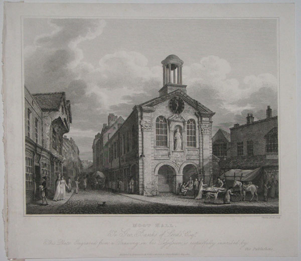
Moot Hall. To Geo.Banks of Leeds, Esqr. This Plate Engraved from a Drawing in his Possession is respectfully inscribed by the Publishers.
Charles Heath, sculp.
Published, by Robinson, Son & Holdsworth, Leeds & J.Hurst, Wakefield, May 1.1816.
Copper engraving. 267 x 305mm.
A Moot Hall was a meeting of assembly building, traditionally to decide loacl issues.
[Ref: 15118] £75.00
(£90.00 incl.VAT)

Moseley Hall, the Residence of Lady Carhampton. Moseley-Hall, Residence of Lady Carhampton. Moseley-Hall is situated on a rising ground, in the village of that name, about three miles from Birmingham. This was next to Mr Russells in the order of destruction... cest a quoi elle se trouva obligée de se conformer, et le Samedi soi 16 Juillet cette belle maison devint la proie des flammes.
Drawn by P.H. Witton Jun.r Engraved by W.m Ellis.
London. Published, 1 May 1792, by J.Johnson, St. Paul's Church Yard.
Aquatint with descriptive text in English and French. Sheet 406 x 260mm. 16 x 10¼". Laid on album page, foxing.
Moseley Hall, belonged to John Taylor, and was burnt down after the rioters had carefully moved all the furniture and belongings of the occupant, the Dowager Lady Carhampton, a relative of George III . The Priestley Riots, the Birmingham Riots of 1791, targeted religious Dissenters, most notably the politically and theologically controversial Joseph Priestley. From "Views of the Ruins of the Principal Houses destroyed during the Riots at Birmingham. 1791." On the 14th of July, 1791, a party having met at an hotel to celebrate the anniversary of the French revolution, collected together as a mob, and proceeded for several days their devastations, setting fire to several meeting-houses and private mansions, but on the arrival of the military from Oxford and Hounslow, order was restored: at the ensuing assizes four of the ring-leaders were convicted, two of whom suffered the penalty of the law. Shortly after this occurrence barracks were erected on the Vauxhall-road, near the town, consisting of a range of handsome buildings, enclosing a spacious area for the exercise of cavalry, and a smaller for parades, a riding-school, a magazine, and an hospital.
[Ref: 21111] £140.00
(£168.00 incl.VAT)
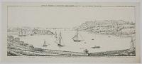
Devil's Point & Mount Edgcombe; from the Fort, near the Telegraph, Plymouth Dock.
W Hawkes Smith del. & fec. Printed from Stone, by WH Smith
[n.d., c.1820]
Lithograph, printed area 185 x 430mm (7¼ x 17"). Slight crease on right; very rare.
View of Plymouth Sound with key indicating (l-r) 'St Nicholas' Island [now known as Drake's Island]/ Mew Stone / Breakwater / O. Cromwell's Tower, Extremity of the Point / Mount Edgcombe / Maker Church / Turret of the Admiral's Landing'. By the little-known Birmingham printmaker William Hawkes Smith (1818-1821, fl.). Ex Collection: The Late Honourable Christopher Lennox-Boyd.
[Ref: 32241] £260.00
(£312.00 incl.VAT)
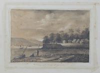
View at Mount Edgcumbe.
T.L. July 26.
Pencil drawing 209 x 286mm. 8¼ x 11¼". Some old glue stains around the image where the mount was fixed.
It is situated within Mount Edgcumbe Country Park, in the parish of Maker on the Rame Peninsula, overlooking Plymouth Sound. The main entrance to the park is in the village of Cremyll. The house was formerly the seat of the Earls of Mount Edgcumbe. This view is part of the gardens that extend to St. John's Lake. See 15971.
[Ref: 15970] £65.00
(£78.00 incl.VAT)
A View of Mount Edgcumbe.
G. Lambert & Scott pinx.t. C.W. Bampflyde delin. Canot sculp.t.
London, Printed for Rob.t Sayer & Bennett, in Fleet Street, Rob.t Wilkinson in Cornhill, John Boydell in Cheapside, & Carington Bowles in St Pauls Church Yard. [n.d., c.1780.]
Engraving. 365 x 565mm (14¼ x 22¼"), on thick paper. Cut inside image. Damaged. Slight surface soiling.
A view of Mount Edgcumbe, Cornwall, painted by George Lambert & Samuel Scott from Plymouth Sound. In the foreground are British ships and longboats. The plate was engraved by Pierre Charles Canot from an intermediary sketch by Coplestone Warre Bampfylde and published in the series 'Five views of and from Mount Edgcumbe, Plymouth', originally issued 1755.
[Ref: 38814] £260.00
(£312.00 incl.VAT)
Mount Edgcumbe near Plymouth in Devonshire. 438 M.
Sold by Dicey & Co, in Aldermary Church Yard London. [n.d. c.1780.]
Hand-coloured engraving. 425 x 540mm. 16¾ x 21¼". Laid on card.
A view of Mount Edgcumbe House and Gardens on the borders of Devon and Cornwall.
[Ref: 24016] £160.00
(£192.00 incl.VAT)
A View of Plymouth Fort and St Nicholas's Island, from Mount Edgcumbe.
G. Lambert & Scott pinx.t. C.W. Bampflyde delin. J. Mason sculp.t.
London, Printed for Rob.t Wilkinson, Cornhill, Rob.t Sayer & Bennett Fleet Street, Carington Bowles, S.t Paul's Ch.chy.d & John Boydell, Cheapside [n.d., c.1780].
Engraving. 390 x 630mm (15½ x 24¾"), with large margins. Repaired tears in inscription area, creasing.
A view of Plymouth Harbour painted by George Lambert & Samuel Scott, engraved by James Mason from an intermediary sketch by Coplestone Warre Bampfylde and first published in 1755 in the series 'Five views of and from Mount Edgcumbe, Plymouth'.
[Ref: 57679] £350.00
A View of Mount Edgcumbe.
G. Lambert & Scott pinx.t. C.W. Bampflyde delin. Canot sculp.t.
London, Printed for Rob.t Sayer & Bennett, in Fleet Street, Rob.t Wilkinson in Cornhill, John Boydell in Cheapside, & Carington Bowles in St Pauls Church Yard. [n.d., c.1780.]
Engraving. 365 x 565mm (14¼ x 22¼"), on thick paper, large margins. Slight surface soiling, edges chipped.
A view of Mount Edgcumbe, Cornwall, with ships and longboats. The plate was engraved by Pierre Charles Canot from an intermediary sketch by Coplestone Warre Bampfylde and published in the series 'Five views of and from Mount Edgcumbe, Plymouth', first issued 1755.
[Ref: 57358] £350.00
(£420.00 incl.VAT)
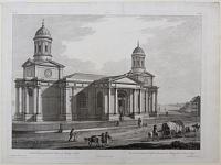
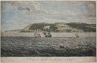
![[View of Mount Edgcumbe taken from the Rope House Plymouth Dock]](img-thumbnail/jpegs/27844.jpg)
[View of Mount Edgcumbe taken from the Rope House Plymouth Dock] To the Rt. H.ble George Edgcumbe. Earl of Mount Edgcumbe, Visc.t Valletort. This view of Mount Edgcumbe, taken from the Rope House Plymouth Dock, is dedicated by his Lordship's most obeient humble serv.t, Carles Tomkins.
Painted by W. Tomkins. Engraved by C. Tomkins.
London. Published May 1st 1790, by C. Tomkins, No. 20 Haymarket.
Stipple engraving, scarce. Printed area: 345 x 345mm. 13.5" x 13.5". Slight creasing.
Mount Edgcumbe House is the former home of the Earls of Mount Edgcumbe.
[Ref: 27844] £260.00
(£312.00 incl.VAT)
![The Late Dr. White's House, King St. [Manchester.]](jpegs/23684.jpg)
![[Manchester Royal Infirmary, Piccadilly Gardens]](jpegs/61287.jpg)

![Margate, with the Arrival of the Hoy. [&] Margate, from the Parade.](jpegs/20598.jpg)
![[Original sketch for Dugdales' England & Wales.] [Margate]](jpegs/60274.jpg)
![[Clock Tower, St Albans.]](jpegs/50409.jpg)
![[Marston Trussell] The Hall Gates [pencil on rear of mount]](jpegs/49395.jpg)


![[Memorial Theatre, Stratford-on-Avon.] 25.](jpegs/14613.jpg)
![Mickleham Church. [pencil.]](jpegs/11662.jpg)


![[Middleton Dale, Derbyshire][in pencil]](jpegs/56566.jpg)


![From the Book-room at the Villetta [two different versions of same view, with double portrait of Henri IV and Maria de Medicis]](jpegs/35680.jpg)


![[Monsal Dale][in pencil]](jpegs/56567.jpg)


![[View of Mount Edgcumbe taken from the Rope House Plymouth Dock]](jpegs/27844.jpg)