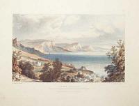
Catalogue: England
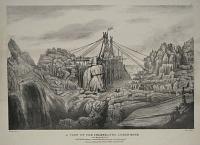
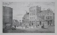
A View Of The Celebrated Logan Rock near the Land's End in Cornwall, taken after the Rock was displaced on the 8th of April, 1824.
J. Tonkin, delin. Vibert. lithog:
Penzance Pubs. by Vibert & Tonkin August 8th. 1824.
Lithograph, sheet 350 x 485mm. 13¾ x 19". Horizontal crease.
The Logan Rock is an eighty ton granite boulder perched on the edge of a headland overlooking the Atlantic ocean one mile south of the Cornish village of Treen. It an example of a logan or rocking stone, being finely balanced due to the actions of weathering. Plate 2 (numbered upper right) from a set of six illustrating the events of 1824: in April Lieutenant Hugh Goldsmith (nephew of the famous poet Oliver Goldsmith) and ten or twelve of his crew of the cutter HMS Nimble rocked the huge granite boulder armed with bars and levers until it fell from its cliff-top perch. Goldsmith was apparently motivated to disprove the claim of Dr. Borlase, who wrote in 'Antiquities of Cornwall' in 1754 that "...the extremities of [the Rock's] base are at such a distance from each other, and so well secured by their nearness to the stone which it stretches itself upon, that it is morally impossible that any lever, or indeed force, however applied in a mechanical way, can remove it from its present situation". The displacement of the rock upset the local residents considerably, since Logan Rock had been used to draw tourists to the area. The Lords of the Admiralty were persuaded to lend Lieutenant Goldsmith the required apparatus for replacing it. The Admiralty sent thirteen capstans with blocks and chains from the dock yard at Plymouth, and contributed £25 towards expenses. After months of effort, at 4.20pm on Tuesday, the 2nd of November, 1824, in front of thousands of spectators and with the help of more than sixty men and block and tackle, the Logan Rock was finally repositioned and returned to "rocking condition". However, it apparently no longer vibrates or "logs" as easily as it did before the incident. Abbey Scenery: 106.
[Ref: 13519] £130.00
(£156.00 incl.VAT)
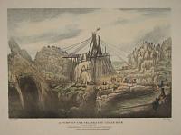
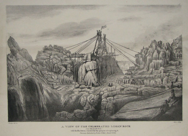
A View Of The Celebrated Logan Rock (near the Land's End) with the Machinery erected for the purpose of replacing it.
Tonkin. delin: Vibert, lithog:
Penzance. Published by Tonkin & Vibert. Novembr. 16 1824.
Lithograph, sheet 330 x 495mm. 13 x 19½". Two horizontal creases.
The Logan Rock is an eighty ton granite boulder perched on the edge of a headland overlooking the Atlantic ocean one mile south of the Cornish village of Treen. It an example of a logan or rocking stone, being finely balanced due to the actions of weathering. Plate 4 (numbered upper right) from a set of six illustrating the events of 1824: in April Lieutenant Hugh Goldsmith (nephew of the famous poet Oliver Goldsmith) and ten or twelve of his crew of the cutter HMS Nimble rocked the huge granite boulder armed with bars and levers until it fell from its cliff-top perch. Goldsmith was apparently motivated to disprove the claim of Dr. Borlase, who wrote in 'Antiquities of Cornwall' in 1754 that "...the extremities of [the Rock's] base are at such a distance from each other, and so well secured by their nearness to the stone which it stretches itself upon, that it is morally impossible that any lever, or indeed force, however applied in a mechanical way, can remove it from its present situation". The displacement of the rock upset the local residents considerably, since Logan Rock had been used to draw tourists to the area. The Lords of the Admiralty were persuaded to lend Lieutenant Goldsmith the required apparatus for replacing it. The Admiralty sent thirteen capstans with blocks and chains from the dock yard at Plymouth, and contributed £25 towards expenses. After months of effort, at 4.20pm on Tuesday, the 2nd of November, 1824, in front of thousands of spectators and with the help of more than sixty men and block and tackle, the Logan Rock was finally repositioned and returned to "rocking condition". However, it apparently no longer vibrates or "logs" as easily as it did before the incident. Abbey Scenery: 106.
[Ref: 13520] £120.00
(£144.00 incl.VAT)
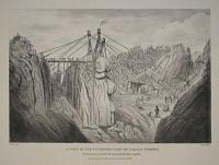
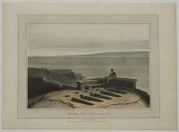
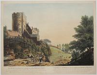
A View Of The Celebrated Logan Rock near the Land's End with the Machinery erected for the purpose of replacing it.
Tonkin. delin: Vibert, lithog:
Penzance. Published by Tonkin & Vibert. Novembr. 16 1824.
Original hand coloured lithograph, sheet 425 x 555mm. 16¾ x 21¾". Two horizontal creases.
The Logan Rock is an eighty ton granite boulder perched on the edge of a headland overlooking the Atlantic ocean one mile south of the Cornish village of Treen. It an example of a logan or rocking stone, being finely balanced due to the actions of weathering. Plate 4 (numbered upper right) from a set of six illustrating the events of 1824: in April Lieutenant Hugh Goldsmith (nephew of the famous poet Oliver Goldsmith) and ten or twelve of his crew of the cutter HMS Nimble rocked the huge granite boulder armed with bars and levers until it fell from its cliff-top perch. Goldsmith was apparently motivated to disprove the claim of Dr. Borlase, who wrote in 'Antiquities of Cornwall' in 1754 that "...the extremities of [the Rock's] base are at such a distance from each other, and so well secured by their nearness to the stone which it stretches itself upon, that it is morally impossible that any lever, or indeed force, however applied in a mechanical way, can remove it from its present situation". The displacement of the rock upset the local residents considerably, since Logan Rock had been used to draw tourists to the area. The Lords of the Admiralty were persuaded to lend Lieutenant Goldsmith the required apparatus for replacing it. The Admiralty sent thirteen capstans with blocks and chains from the dock yard at Plymouth, and contributed £25 towards expenses. After months of effort, at 4.20pm on Tuesday, the 2nd of November, 1824, in front of thousands of spectators and with the help of more than sixty men and block and tackle, the Logan Rock was finally repositioned and returned to "rocking condition". However, it apparently no longer vibrates or "logs" as easily as it did before the incident. Abbey Scenery: 106.
[Ref: 13521] £260.00
(£312.00 incl.VAT)
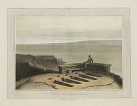
A View Of The Southern Part Of Castle Treryn, with the Machinery erected for the purpose of replacing the Logan Rock.
Tonkin, Delin: Vibert, Lithog:
Penzance, Published by Vibert & Tonkin November 16, 1824.
Lithograph, sheet 435 x 590mm. 17 x 23¼".
The Logan Rock is an eighty ton granite boulder perched on the edge of a headland overlooking the Atlantic ocean one mile south of the Cornish village of Treen. It an example of a logan or rocking stone, being finely balanced due to the actions of weathering. Plate 5 (numbered upper right) from a set of six illustrating the events of 1824: in April Lieutenant Hugh Goldsmith (nephew of the famous poet Oliver Goldsmith) and ten or twelve of his crew of the cutter HMS Nimble rocked the huge granite boulder armed with bars and levers until it fell from its cliff-top perch. Goldsmith was apparently motivated to disprove the claim of Dr. Borlase, who wrote in 'Antiquities of Cornwall' in 1754 that "...the extremities of [the Rock's] base are at such a distance from each other, and so well secured by their nearness to the stone which it stretches itself upon, that it is morally impossible that any lever, or indeed force, however applied in a mechanical way, can remove it from its present situation". The displacement of the rock upset the local residents considerably, since Logan Rock had been used to draw tourists to the area. The Lords of the Admiralty were persuaded to lend Lieutenant Goldsmith the required apparatus for replacing it. The Admiralty sent thirteen capstans with blocks and chains from the dock yard at Plymouth, and contributed £25 towards expenses. After months of effort, at 4.20pm on Tuesday, the 2nd of November, 1824, in front of thousands of spectators and with the help of more than sixty men and block and tackle, the Logan Rock was finally repositioned and returned to "rocking condition". However, it apparently no longer vibrates or "logs" as easily as it did before the incident. On J. Whatman watermarked paper 1824. Abbey Scenery: 106.
[Ref: 13522] £220.00
(£264.00 incl.VAT)
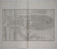
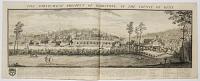
Plan of the Gardens, Plantations &c: of Long Leate in Wiltshire , the Seat of the Rt. Hon:ble the Lord Vis:t Weymouth. Les Jardins &c de Long Leate de dans l'Comte de Wilts. p: 63. Vol: 3.d [Key lettered A to W, top left-hand corner.]
Ca: Campbell Delin: H: Hulsbergh Sculp:
[n.d. c.1731.]
Copper Engraving. Plate 305 x 502mm. 12 x 19¾". Vertical fold through centre.
Garden plan from Henry Hulsberg's "Vitruvius Britannicus" series by c. Campbell. Thomas Thynne, 1st Viscount Weymouth (1640-1714) was a British peer, at Longleat, Wiltshire. A great Elizabethan house (1580) with garden and park. It once had an Elizabethan garden and a park designed by London and Wise in the 1680s, [See ref:18008]. Lancelot Brown re-designed them after 1757. It is noted for its Elizabethan country house, maze, landscaped parkland and safari park. See ref: 18011, 18008
[Ref: 18012] £260.00
(£312.00 incl.VAT)
![[Longleat] Long Leate in Wiltshire, The Seat of the Right Honourable the Lord Viscount Weymouth &c:](img-thumbnail/jpegs/58770.jpg)
[Longleat] Long Leate in Wiltshire, The Seat of the Right Honourable the Lord Viscount Weymouth &c:
Ca: Campbell Delin: H. Hulsbergh Sculp:
[n.d. c.1725.]
Engraving. 250 x 505mm (9¾ x 19¾"), large margins.
An elevation of Longleat, regarded as one of the finest examples of Elizabethan architecture, designed by Robert Smythson for Sir John Thynne and completed c.1580. Published in Colen Campbell's 'Vitruvius Britannicus'.
[Ref: 58770] £260.00
(£312.00 incl.VAT)

"Looe" - the ferry. [in pencil.]
Mabel Oliver Parker. [pencil signature.]
[n.d. c.1920.]
Etching. 216 x 311mm. 8½ x 12¼".
Looe, Cornwall. This old ferry goes along the Fowey estuary between Bodinnick and Polruan.
[Ref: 18060] £140.00
(£168.00 incl.VAT)

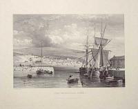
Port-looe, Cornwall.
Drawn & Engraved by Will.m Daniell.
Published by W. Daniell, Russell Place, Fitzroy Square, London May 20. 1825.
Aquatint with original hand colour. 230 x 300mm (9 x 12") large margins. Laid on card as usual.
A view of the port town of Looe. From William Daniell's 'A Voyage Round Great Britain', a series of 308 aquatints published in eight volumes between 1814-1825, described by R.V. Tooley as 'the most important colour plate book on British Topography'. Abbey: Scenery, 16; Tooley: Books with Coloured Plates 177.
[Ref: 47278] £180.00
(£216.00 incl.VAT)
![[East Looe and West Looe.]](img-thumbnail/jpegs/34725.jpg)
[East Looe and West Looe.]
[Drawn by J. Farington R.A. Engraved by W. Woolnoth.]
[London, Published May 1. 1813, by T. Cadell & W. Davies, Strand.]
Unfinished proof before all letters. Engraving with very large margins. Plate 229 x 280mm (9 x 11"). Small pinholes in image area.
A view or Looe, the small coastal town and fishing port in Cornwall. Looe is divided in two by the River Looe, East Looe and West Looe, connected only by the arched bridge, this was replaced by a newer seven-arched bridge in 1853. Plate 19 from 'Britannia Depicta: a Series of Views (with brief Descriptions) of the most interesting and picturesque Objects in Great Britain...' by Joseph Farington.
[Ref: 34725] £75.00
(£90.00 incl.VAT)
![[Louth] To the Worshipful the Warden and Assistants of the Corporation of Louth,](img-thumbnail/jpegs/51233.jpg)
[Louth] To the Worshipful the Warden and Assistants of the Corporation of Louth, This North West View of the Town of Louth is Inscribed By their obliged humble Serv.ts Tho.s Espin and Bart.w Howlett.
Drawn by Thomas Espin. Engraved by B. Howlett.
Publish'd as the Act directs April 17th [1793?] by John Jackson Lincolnshire.
Scarce etching. Sheet 430 x 585mm (17 x 23"). Trimmed within plate, some surface wear including loss of date, repairs left top corner.
A view of Louth, Lincolnshire, with workers harvesting hay in the fireground and a windmill on the far horizon. Thomas Espin (1767-1822) was an amateur artist who ran a 'Mathematical, Architectural, Nautical and Commercial Academy' in Louth. This plate was first published by the engraver, Bartholomew Howlett, in London, 1793; this example was issued by local Louth publisher John Jackson who operated until at least 1811. See BM 1870,0514.2877 for earlier version.
[Ref: 51233] £320.00
Louth Market Place.
On Stone by T.W. Wallis, Louth.
Printed by W. Monkhouse, York.
Rare lithograph. 250 x 390mm (15¼ x 11½"). Foxing around image and in title area.
The market place in Louth, Lincolnshire.
[Ref: 8794] £160.00
(£192.00 incl.VAT)
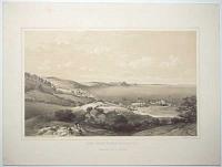
View near Lower Heysham, Lancashire.
Drawn & Engraved by Will.m Daniell.
Published by Mess.rs Longman, & Co. Paternoster Row, & W. Daniell, 9 Cleveland St. Fitzroy Square, London. March, 1, 1816.
Aquatint with fine original hand colour. On watermarked paper, 'J. Whatman. 1815'. 230 x 300mm (9 x 12"). Large margins, uncut.
A view depicting a man seated on a low stone wall overlooking Morecambe Bay. From William Daniell's 'A Voyage Round Great Britain', a series of 308 aquatints published in eight volumes between 1814-1825, described by R.V. Tooley as 'the most important colour plate book on British Topography'. Abbey: Scenery, 16; Tooley: Books with Coloured Plates 177.
[Ref: 36127] £160.00
(£192.00 incl.VAT)
View near Lower Heysham, Lancashire.
Drawn & Engraved by Will.m Daniell.
Published by Messrs. Longman & Co., Paternoster Row & W.Daniell, 9 Cleveland Street, Fitzroy Square, London, March 1, 1816.
Hand coloured aquatint with large margins. Platemark: 230 x 290mm (9 x 11¼").
A man is seated on a low stone wall overlooking Morecambe Bay, near empty graves in the ground. From William Daniell's 'A Voyage Round Great Britain', a series of 308 aquatints published in eight volumes between 1814-1825, described by R.V. Tooley as 'the most important colour plate book on British Topography'. Abbey: Scenery, 16; Tooley: Books with Coloured Plates 177.
[Ref: 33887] £70.00
(£84.00 incl.VAT)
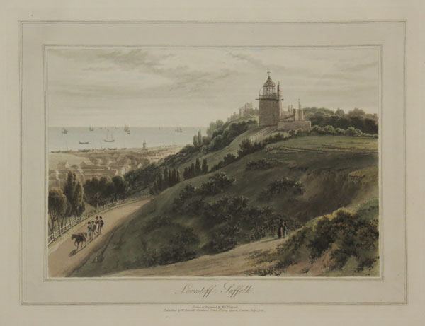
Lowestoff, Suffolk.
Drawn & Engraved by Will.m Daniell.
Published by Mess.rs Longman, & Co. Paternoster Row, & W. Daniell, 9 Cleveland St. Fitzroy Square, London. July, 1, 1822.
Aquatint with fine original hand colour. On watermarked paper, 'J. Whatman. 1821'. 230 x 300mm (9 x 12"). Mint, with large margins, uncut.
A view of Lowestoft from a hillside. A lighthouse is on a hilltop in the middle ground in the centre, with the town on the coast to the left. From William Daniell's 'A Voyage Round Great Britain', a series of 308 aquatints published in eight volumes between 1814-1825, described by R.V. Tooley as 'the most important colour plate book on British Topography'. Abbey: Scenery, 16; Tooley: Books with Coloured Plates 177.
[Ref: 36145] £190.00
(£228.00 incl.VAT)
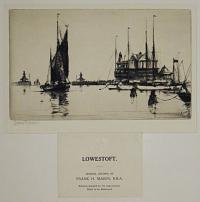
![[Lowestoft.]](img-thumbnail/jpegs/61057.jpg)
[Lowestoft.]
Frank H. Mason [pencil].
[n.d., c.1920.]
Etching, signed by the artist, blindstamps in margin. 140 x 230mm, with very large margins. Mint.
A fishing ketch in Lowestoft Harbour. Frank H. Mason (1876 - 1965) was a cadet on HMS Conway. Having served in the Royal Navy in the First World War, Mason became a war artist, with several such images held at the Imperial War Museum. Between the wars he became a full-time artist, working as an illustrator, a poster artist for railway companies, and supplying posters and postcards for shipping companies. From 1900 onwards he exhibited at the RA, and was awarded R.I. in 1929. Mason illustrated the book North Sea Fishers and Fighters in 1911, and was a 'significant artist of marine and coastal scenes, as well as an illustrator of shipping books'.
[Ref: 61057] £180.00
(£216.00 incl.VAT)

Lowestoff, Suffolk.
Drawn & Engraved by Will.m Daniell.
Published by W. Daniell, Russell Place, Fitzroy Square, London, July 1. 1822.
Aquatint with fine original hand colour. 230 x 300mm (9 x 12"). Large margins.
A view of the coastal town of Lowestoft showing the lighthouse upon the hill. From William Daniell's 'A Voyage Round Great Britain', a series of 308 aquatints published in eight volumes between 1814-1825, described by R.V. Tooley as 'the most important colour plate book on British Topography'. Abbey: Scenery, 16; Tooley: Books with Coloured Plates 177.
[Ref: 47141] £230.00
(£276.00 incl.VAT)
Lowestoft. Original Etching by Frank H. Mason, R.B.A. Edition linited to 175 impressions. Plate to be destroyed.
Frank H. Mason [pencil.]
[London: Alfred Bell & Co., n.d., c.1935.]
Drypoint, signed in pencil by the artist. 140 x 230mm (5½ x 9"), very large margins, publisher's blind stamps. In original mount with printed label with title as above, with publisher's 'Minerva's Head' & 'A B C' logo. Mint.
By Frank Henry Mason (1875-1965), an artist best known for his maritime, shipping, coastal and harbour paintings and as a creator of art deco travel and British railway posters. From 1900 onwards he exhibited at the RA, and was awarded R.I. in 1929.
[Ref: 49159] £160.00
(£192.00 incl.VAT)

View of Lowestoft Harbour. Respectfully dedicated to the Inhabitants of Lowestoft, By their obedient Servant, The Publisher.
W. Rushmer, Delt. & Lith.
Published by W. Rushmer, Bookseller &c. London Road, Lowestoft. [n.d. c.1837.]
Tinted lithograph. 280 x 376mm. 11 x 14¾". Some nicks and toning along lower edge.
Lowestoft Harbour, Suffolk. The original inner harbour was built by the Lowestoft and Norwich Navigation Company and was constructed in 1837. The development of the harbour led to a rapid growth in the fishing industry and associated engineering and ship building companies such as Brooke Marine, Richard and Boulton and Paul. Large scale ship building, which included the building of vessels for the Royal Navy, continued into the 1980s.
[Ref: 25619] £170.00
(£204.00 incl.VAT)

Lows Water
Drawn by J. Smith / Engraved by Merigot
London Pub Jan.y 1 1798 by Darling & Thompson Gt. Newport Street, and T. Simpson St Pauls Church Yard
Coloured etching and aquatint, sheet 310 x 435mm (12½ x 17"). Trimmed inside platemark.
Loweswater, Cumberland. A View usually bound up with Clarke's 'Survey of the Lakes', after John Smith (1749-1831), watercolour painter from Cumberland. See Ref: 38648
[Ref: 38649] £80.00
(£96.00 incl.VAT)
![Broad Street, Ludlow. [pencil.]](img-thumbnail/jpegs/11949.jpg)
Broad Street, Ludlow. [pencil.]
Samuel Chamberlain [signed in pencil.]
[n.d., c.1930s.]
Drypoint etching, 200 x 255mm. 8 x 10".
By Samuel Chamberlain (1895 - 1975), American artist, architect, etcher, lecturer; born Cresco, Iowa, USA.
[Ref: 11949] £140.00
(£168.00 incl.VAT)
South East View of Ludlow.
Drawn & Engraved on Steel & Published Dec.r 1826 by H.B. Ziegler, London.
Mezzotint, proof. Plate: 230 x 330mm (9 x 13''), with large margins.
A view of Ludlow from the River Teme, four men fishing from the banks.
[Ref: 50591] £140.00
(£168.00 incl.VAT)

Entrance of Ludlow Castle, Shropshire. Antiquities No.1.
Painted by W. Hodges. Engraved by V. Green and F. Jukes.
[n.d., c.1778.]
Very rare aquatint. Printed in sepia. Open letter proof impression. Rare. Sheet size: 490 x 340mm (19¼ x 13¼") Trimmed inside plate. Creases to sheet.
A proof impression of plate 1 from Valentine Green's 'Antiquities', published 1778. The ruins of the castle gate of Ludlow Castle, with rustic figures and a horse-drawn cart at the entrance. After landscape painter William Hodges (1744-1797), who had sailed with Captain James Cook and recorded his discoveries, returning to Britain in 1775. Ex collection of the Hon. Christoper Lennox-Boyd.
[Ref: 37813] £240.00
(£288.00 incl.VAT)

Ludlow Castle, & the Steeple of St Lawrence, with a distant View of the Clee Hills. Proof.
Drawn by W. Gwynn. J.W. Wright sc.t.
London. Published April 10th 1807 by W. Gwynn and Sold by Tomkins, 49 New Bond Street.
A scarce proof aquatint. 420 x 495mm (16½ x 19½"). Narrow margins. surface abrasion in sky.
A view of Ludlow Castle at the time it was becoming a tourist attraction.
[Ref: 45788] £420.00

Vol .I.p.163. West Lullworth Cove belonging to T. Weld Esqr. N.B. This Cove is 1380 feet in diameter, and 21 feet in depth at low water. [&] Vol.I.p.130. S. East View of Bindon Abbey belonging to T. Weld Esq.r.
Engrav'd by James Basire. 1773.
Engraving, plate 370 x 235mm (14½ x 9¼"), with large margins. On 18th century watermarked paper. Some cockling.
Two views in Dorset. See also 15747.
[Ref: 60050] £120.00
(£144.00 incl.VAT)
Lullworth Castle.
Thos. Morris Esqr. delt. J. Fittler sculp.
Publish'd May 1790 by I. Fittler London, & I Love Waymouth.
Etching and aquatint with watercolour wash, with large margins, scarce, paper watermarked for J. Whatman, platemark 260 x 300mm (10¼ x 11¾"). Very large margins.
Two horse riders and their hounds passing Lulworth Castle, Dorset, an early 17th century mock castle. Originally it was built as a hunting lodge for Thomas Howard, 3rd Lord Bindon, in 1610. In 1641 it was purchased by property developer Humphrey Weld for £42,860. The castle is still owned by the Weld family. Many properties were held by the family, but in 1793 Thomas Weld donated Stonyhurst Hall to the Society of Jesus. From the oblong folio 'Views of Waymouth' (1791, 12 plates) after J. Nixon, A. Beaumont; T. Morris, F. Bowles, and J. Love. Abbey Scenery 339.6; for the complete set see ref. 35799.
[Ref: 37976] £190.00
(£228.00 incl.VAT)
Lullworth Castle, in Dorsetshire. The Seat of Thos. Weld Esqr. To whom this Plate is most respectfully Inscribed by his obliged and obedient humble Servant James Fittler.
Publish'd as the Act directs Augt.1.1789 by J. Fittler No.62, Upper Charlotte Street, Rathbone Place, London.
Engraving. Plate 342 x 438mm. 13½ x 17¼". Vertical fold down the centre.
Lulworth Castle, Dorset, is an early 17th century mock castle. Orginally it was built as a hunting lodge for Thomas Howard in 1610. In 1641 it was purchased by Humphrey Weld. The castle is still owned by the Weld family. Many properties were held by the family, but in 1793 Thomas Weld donated Stonyhurst Hall to the Society of Jesus.
[Ref: 15743] £160.00
(£192.00 incl.VAT)

Lullworth Castle.
Thos. Morris Esqr. delt. J. Fittler sculp.
Publish'd May 1790 by I. Fittler London, & I Love Waymouth.
Etching and aquatint, with large margins, scarce, paper watermarked for J. Whatman. 260 x 300mm, 10¼ x 11¾". Some spotting, mostly marginal; slightly tatty extremities.
Two horse riders and their hounds passing Lulworth Castle, Dorset, an early 17th century mock castle. Originally it was built as a hunting lodge for Thomas Howard in 1610. In 1641 it was purchased by Humphrey Weld. The castle is still owned by the Weld family. Many properties were held by the family, but in 1793 Thomas Weld donated Stonyhurst Hall to the Society of Jesus. From the oblong folio 'Views of Waymouth' (1791, 12 plates) after J. Nixon, A. Beaumont; T. Morris, F. Bowles, and J. Love. See BL Maps C.10.a.15. See item 22300 for titlepage.
[Ref: 22304] £260.00
(£312.00 incl.VAT)

Lulworth Castle.
Drawn by H. Horsnell. C. Graf, Lith. to Her Majesty.
Published by B. Benson, Library, Weymouth. [n.d. c.1830.]
Lithograph on india, very large margins. Sheet 222 x 285mm (8¾ x 11¼"). Rare.
Lulworth Castle, in East Lulworth,. Dorset. In 1610 the Castle was built as a hunting lodge by Thomas Howard. A Roman Catholic chapel was built in the grounds in 1786. Following the French Revolution, the surviving members of the French Royal family were allowed to use Lulworth as one of their residences-in-exile. Charles X of France stayed here briefly in 1830.
[Ref: 31298] £60.00
(£72.00 incl.VAT)

Town Hall and Market House, Lutterworth. Joseph Hansom Arch.t.
H. Harris Lithog.
[n.d., c.1836.]
Lithograph on india paper. 180 x 230mm, 7 x 9".
The town hall of Lutterworth, Leicestershire, was funded by public subscription in 1836. The architect, Joseph Aloysius Hansom (1803-82) was the inventor of the Hansom Cab. His St Walburge's Church in Preston has the tallest church spire in England.
[Ref: 11578] £70.00
(£84.00 incl.VAT)
High Street, Lutterworth. Proof.
[n.d., c.1850.]
Very scarce coloured lithograph. Sheet 245 x 305mm (9¾ x 12").
A rare view of Lutterworth in Leicestershire, looking uphill.
[Ref: 37120] £160.00
(£192.00 incl.VAT)

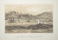
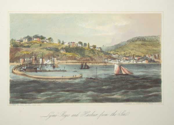
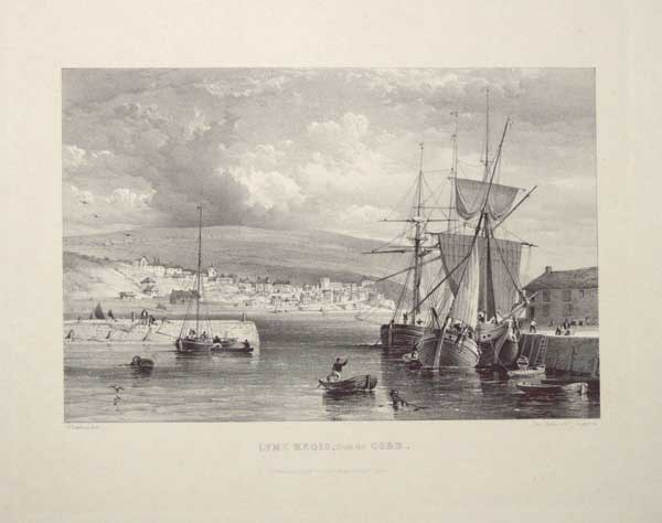
Lyme Regis and Harbour from the Sea.
Lithographed by Newman & Co, 48 Watling St. London.
Published by Daniel Dunster, Lyme Regis [n.d., c.1840].
Tinted lithograph with hand colour. Printed area 185 x 270mm (7¼ x 10½"), with large margins.
A view of Lyme Regis from outside the Cobb. Daniel Dunster also published 'An Account of and Guide to the Mighty Landslip of Dowlands and Bindon, near Lyme Regis', with plans and views, regarded as an important record of the nearby cliff collapse of 1839. Not in Abbey.
[Ref: 57823] £140.00
(£168.00 incl.VAT)
Lyme Regis and Harbour from the Sea.
Lithographed by Newman & Co, 48 Watling St. London.
Published by Daniel Dunster, Lyme Regis [n.d., c.1840].
Tinted lithograph. Printed area 185 x 270mm (7¼ x 10½"), with large margins.
A view of Lyme Regis from outside the Cobb. Daniel Dunster also published 'An Account of and Guide to the Mighty Landslip of Dowlands and Bindon, near Lyme Regis', with plans and views, regarded as an important record of the nearby cliff collapse of 1839. Not in Abbey.
[Ref: 57824] £95.00
(£114.00 incl.VAT)
Lyme Regis, from the Cobb.
G. Hawkins, Lith.
Published by D. Dunster, Library, Broad St. Lyme Regis [n.d., c.1840].
Lithograph. Printed area 170 x 230mm (6¾ x 9"), with large margins.
A view of Lyme Regis with boats at the quay in the foreground. Daniel Dunster also published 'An Account of and Guide to the Mighty Landslip of Dowlands and Bindon, near Lyme Regis', with plans and views, regarded as an important record of the nearby cliff collapse of 1839. Not in Abbey.
[Ref: 57825] £95.00
(£114.00 incl.VAT)

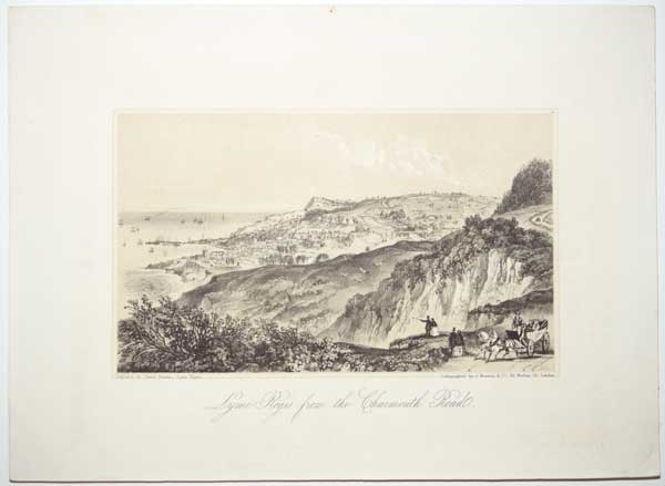
Lyme Regis from the Charmouth Road.
Lithographed by Newman & Co, 48 Watling St. London.
Published by Daniel Dunster, Lyme Regis [n.d., c.1840].
Tinted lithograph. Printed area 190 x 265mm (7½ x 10½"), with large margins.
A view of Lyme Regis from the east, with the Landslip. Daniel Dunster also published 'An Account of and Guide to the Mighty Landslip of Dowlands and Bindon, near Lyme Regis', with plans and views, regarded as an important record of the nearby cliff collapse of 1839. Not in Abbey.
[Ref: 57826] £95.00
(£114.00 incl.VAT)
Lyme Regis, from Holm Bush Hill.
On Stone by G. Hawkins from a sketch by George Willis. Day & Son, Lith.rs to the Queen.
Published by D. Dunster, Lyme Regis [n.d., c.1840].
Tinted lithograph. Printed area 190 x 265mm (7½ x 10½"), with large margins.
A view of Lyme Regis from the west, with the Cobb, looking towards Golden Cap. Daniel Dunster also published 'An Account of and Guide to the Mighty Landslip of Dowlands and Bindon, near Lyme Regis', with plans and views, regarded as an important record of the nearby cliff collapse of 1839. Not in Abbey.
[Ref: 57827] £140.00
(£168.00 incl.VAT)
Lyme Regis. From a Drawing in the Possession of the Rev. Dr. Hodges.
G. Hawkins, Jun.r lith. Day & Haghe Lith.rs to the Queen.
Published & Sold by D. Dunster, Lyme Regis [n.d., c.1840].
Tinted lithograph with fine hand colour. Printed area 150 x 220mm (6 x 8¾), with large margins.
A view of Lyme Regis from the west, looking along the cliffs towards Golden Cap. Daniel Dunster also published 'An Account of and Guide to the Mighty Landslip of Dowlands and Bindon, near Lyme Regis', with plans and views, regarded as an important record of the nearby cliff collapse of 1839. Not in Abbey.
[Ref: 57828] £140.00
(£168.00 incl.VAT)
![Lyme from Holme Bush. [&] Lyme from Charmouth Fields.](img-thumbnail/jpegs/24578.jpg)
Lyme from Holme Bush. [&] Lyme from Charmouth Fields.
W. Gauci Lith.
Published by H. Locke [n.d. c.1850.]
Very rare pair of lithographs. 130 x 185mm (5 x 7¼").
A pair of lithographs of Lyme Regis, from Holme Bush with a view across the harbour eastwards; and Lyme Regis from Charmouth Fields looking out to sea.
[Ref: 24578] £130.00
(£156.00 incl.VAT)
view all images for this item
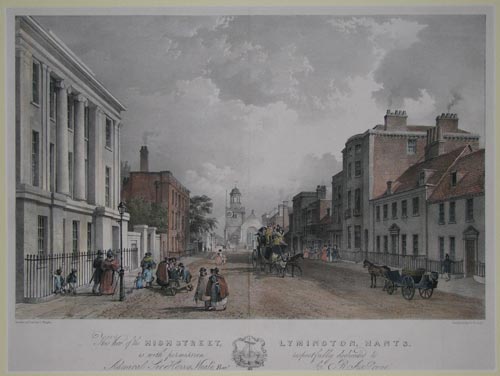
This View of the High Street, Lymington, Hants. is with permission respectfully dedicated to Admiral Sir Harry Neale, Bart. by R. A. Grove.
Drawn on Stone by L. Haghe. Sketched by B. Ferrey.
[n.d. c.1840.]
Coloured lithograph. Mounted. Sheet 355 x 475mm. 14" x 18¾". Crease vertically down the middle of the image.
A Street scene of Lymington High Street.
[Ref: 8964] £320.00
![[Lymington] Plate I. To Sir Will.m Heathcote Bar.t M.P. This View near Lymington in Hampshire is most respectfully inscribed by his obedient humble servant F. Jukes.](img-thumbnail/jpegs/55538.jpg)
[Lymington] Plate I. To Sir Will.m Heathcote Bar.t M.P. This View near Lymington in Hampshire is most respectfully inscribed by his obedient humble servant F. Jukes. [&] Plate II. To Will. Chute Esq.r M.P. This View... [&] Plate III. To Sir Harry Burrand Bar.t M.P. This View... [&] Plate IV. To N.B. Halhead Esq.r M.P. This View...
W.R. Bigg A Pinxt. F. Jukes Aqua.t.
London, Pub.d Jan. 1st 1795. By F.Jukes No 10 Howland Street.
Set of four aquatints, 2 have pt Whatman 1794 watermark. Sheet 260 x 295mm (10¼ x 11½"). Trimmed into image, losing edges of inscriptions at sides.
A set of four views of rural scenery around Lymington, Hampshire, after William Redmore Bigg (1755-1828)
[Ref: 55538] £350.00
view all images for this item
![[Lymm] View at Lynn.](img-thumbnail/jpegs/44229.jpg)
[Lymm] View at Lynn.
[after Joseph Farington.]
[n.d., c.1790.]
Soft ground etching. Sheet 270 x 290mm (10½ x 15¼"). Trimmed into wash border as issued, laid on board.
Lymm Bridge, over the Bridgewater Canal in Lymm, Cheshire.
[Ref: 44229] £140.00
(£168.00 incl.VAT)
Lymne Castle, with a distant View of the French Coast. It is situated on the descent of a Hill, about two miles West of Hythe: Its remains bear marks of great Antiquity, but when, or by whom founded, is not certain: It has been suppos'd to be the famous Portius Lemanis; but that the Sea had retired from its spacious Haven, once a Harbour for 250 Danish Vessels, Anno 893. Here it was that Prince Edward, exacted the Oath from the Barons of the Cinque Ports.
Dayes del.t. Jukes aq.t.
[London, Pub.d Jany. 31. 1790 by F. Jukes Engraver, Howland Street.] [but later.]
Coloured aquatint very rare & fine. Sheet 390 x 500mm (15¼ x 19¾"). Tear in inscription area skillfully repaired.
Lympne Castle, built at the former Roman Channel port of 'Portus Lemanis'. The topographical watercolours of Edward Dayes (17631804) often contained ruins, and had an influence on the early work of J.M.W. Turner.
[Ref: 36754] £320.00
![[Maddington, Wilts.]](img-thumbnail/jpegs/16119.jpg)
[Maddington, Wilts.] [Written in pencil on verso:] The gate on the left leads into W. E. Erle Drax's Farm yard. The Road & firm barred Gate to the Manor House.
JB 1857 [in pencil bottom right.]
Original watercolour. 209 x 266mm. 8¼ x 10½".
Maddington, Wiltshire. The entrance to the residence of the Ernle Baronetcy. This was probably the residence ot Jane Frances Earl-Drax-Grosvenor and her husband John Samuel Wanley Sawbridge.
[Ref: 16119] £130.00
(£156.00 incl.VAT)

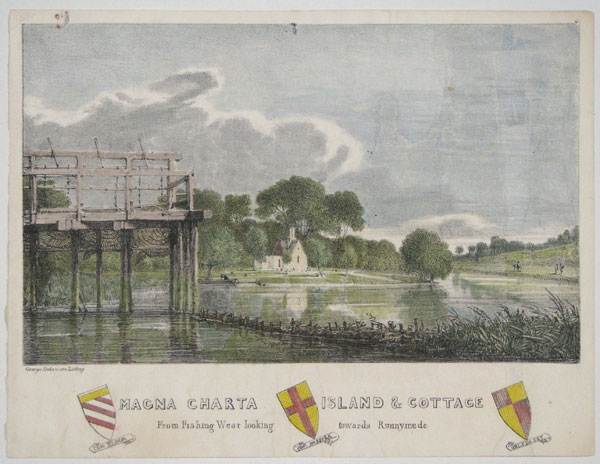
Magna Charta Island & Cottage. From Fishing Wear looking towards Runnymede.
George Delamotte Lithog.
[n.d. c.1810.]
A very rare hand-coloured lithograph. 196 x 255mm. 7¾ x 10".
Magna Carta Island, is in the River Thames on the reach above the Bell Weir Lock. It is considered as one of the several contenders for being the place where, in 1215, King John sealed the Magna Carta.
[Ref: 15599] £140.00
(£168.00 incl.VAT)

Maidenhead Bridge.
W.Westall. A.R.A. del.t. J.Bailey sculp.t.
Published 1828, by R.Ackermanm, 96 Strand, London.
Coloured aquatint. 220 x 280mm.
ABBEY: Scenery 435.
[Ref: 6537] £160.00
(£192.00 incl.VAT)

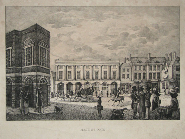
Maidstone.
[n.d., c.1820s.]
Lithograph, sheet 300 x 390mm. 11¾ x 15½".
An interesting and rare view of Maidstone, the county town of Kent. Shows shops, carts and figures in a square.
[Ref: 12285] £230.00
(£276.00 incl.VAT)
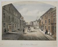
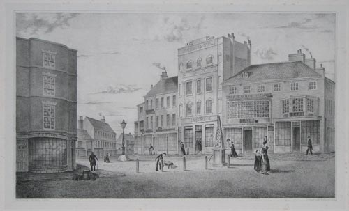
The North-West Prospect of Maidstone, in the County of Kent.
Sam.l and Nath.l Buck delin. et Sculp.t.
According to Act of Parliament 1738.
Engraving. Plate: 310 x 790mm (12¼ x 31"). Central fold as normal, slight offsetting in title.
A view of the port at Maidstone, with a descriptive text below and a key to the right, indicating various landmarks and buildings. From the series 'Buck's Perspective Views of Cities and Chief Towns in England and Wales', before the addition of a plate number top right.
[Ref: 43066] £420.00

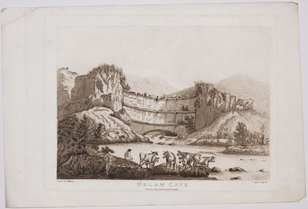
Melam Cove.
Drawn by J. Rathbone. Aquat.a J. Hassell.
Published 1st Sept.r 1788, by J. Hassell Strand.
Sepia aquatint, with large margins. 240 x 300mm (9½ x 11¾"). Small tear in margin.
A rare early aquatint view of Malham Cove, North Yorkshire, by John Rathbone (c.1750-1807). Born in Cheshire, he exhibited forty-eight landscapes at the Royal Academy 1785-1806. George Morland sometimes collaborated with Rathbone, painting the figures in his landscapes.
[Ref: 31573] £110.00
(£132.00 incl.VAT)
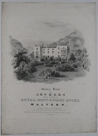
Garden Front of Archers (Late Downes) Royal Kent & Foley Hotel Malvern. Families boarded in private Apartments. Good Post Horses, with closed and open Carriages, Excellent Stables, for Horses ar Livery with commodious Coach houses.
Drawn on Stone by H. Lamb.
[n.d., c.1840.]
Lithograph. Printed area 290 x 250mm, 11½ x 10".
An advertisement showing a view of the rear of the Georgian coaching hotel, built in 1818 by Samuel Deykes to cash in on the new spa tourism. In 1830 it was renamed the Royal Kent Coburg and Foley Hotel, after the Duchess of Kent and the 12-year-old Princess Victoria visited and left their approval. Edward Archer, a local vintner, took over the hotel in the late 1830s, and his son John was in charge in the 1860s. Today it is the Foley Arms Hotel.
[Ref: 22928] £140.00
(£168.00 incl.VAT)

Manchester from Mount Pleasant. Dedicated to the Inhabitants of Manchester and its Environs, by their obliged Servants, W.M.Craig and J.Landseer.
Drawn by W.M.Craig. Engraved by J. Landseer, Engraver to the King
Published Aug.t 1 1802 by J. Landseer, No 88 Queen Anne Street, East. & W.M.Craig, No 88 Charlotte Street, Rathbone Place, London; and in Manchester at No 79 Market Street Lane.
Scarce engraving. 365 x 480mm (14¼ x 18¾"), very large margins.
A fine prospect of Manchester from sheep fields to the north of the city. John Landseer, the engraver, was the father of Sir Edwin Landseer.
[Ref: 58706] £380.00
The South West Prospect of Manchester, in the County Palatine of Lancaster.
S & N Buck delin.t et sculp.t. 1728.
[London: Robert Sayer, c.1774.]
Coloured engraving. 255 x 710mm (10 x 28"), large margins.
A detailed prospect of Manchester, with an engraved description and a 7-point key below. From the series 'Buck's Perspective Views of Cities and Chief Towns in England and Wales', as re-issued by Robert Sayer, with a plate number top right.
[Ref: 60393] £450.00


![[Longleat] Long Leate in Wiltshire, The Seat of the Right Honourable the Lord Viscount Weymouth &c:](jpegs/58770.jpg)


![[East Looe and West Looe.]](jpegs/34725.jpg)
![[Louth] To the Worshipful the Warden and Assistants of the Corporation of Louth,](jpegs/51233.jpg)


![[Lowestoft.]](jpegs/61057.jpg)


![Broad Street, Ludlow. [pencil.]](jpegs/11949.jpg)


![Lyme from Holme Bush. [&] Lyme from Charmouth Fields.](jpegs/24578.jpg)
![[Lymington] Plate I. To Sir Will.m Heathcote Bar.t M.P. This View near Lymington in Hampshire is most respectfully inscribed by his obedient humble servant F. Jukes.](jpegs/55538.jpg)
![[Lymm] View at Lynn.](jpegs/44229.jpg)

![[Maddington, Wilts.]](jpegs/16119.jpg)