Catalogue: England
![[A Room Built by Sir James Burrows on the Castle Bank at Starburgh near Lingfield Surrey.]](img-thumbnail/jpegs/13297.jpg)
[A Room Built by Sir James Burrows on the Castle Bank at Starburgh near Lingfield Surrey.]
Engraved by E. Malpas.
[London, c.1810.]
Engraving, image 265 x 375mm. 10½ x 14¾". Trimmed within plate.
A riverside view of an 18th century gothic building on the Starborough Estate, Lingfield, Surrey; the residence of Sir James Burrow (1701 - 1782), legal reporter. A gardener rests on his roller with his dog in the foreground to left, three figures on the opposite bank; swans on the river. See 13296.
[Ref: 13297] £220.00
(£264.00 incl.VAT)
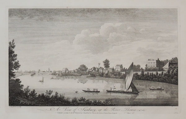
A View of Sunbury, up the River Thames. No.2.
J. Boydell Del. & Sculp.
Pulish'd according to Act of Parliament by J. Boydell at the Unicorn the Corner of Queen Street Cheapside. Price 1s. [1770.]
Engraving, paper watermarked with very large margins. Plate 260 x 425mm (10¼ x 16¾").
A view along the River Thames at Sunbury, from "A Collection of One Hundred Views In England and Wales". John Boydell's 'Collection of Views' was made after he turned from engraver to print publisher in 1767. The first collection was issued in 1770, and included some plates by printmakers other than himself. Adams (London): 47.2.
[Ref: 29295] £250.00
(£300.00 incl.VAT)
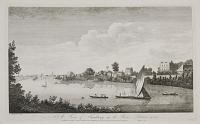
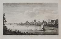
A View of Sunbury, up the River Thames. No.2.
J. Boydell Del. & Sculp.
Publish'd according to Act of Parliament by J. Boydell at the Unicorn the Corner of Queen Street Cheapside. Price 1.s. [n.d. c.1750.]
Engraving, printed on 18th century watemarked paper. Plate 260 x 431mm. 10¼ x 17". Large margins.
A view of Sunbury-on-Thames, in Surrey. Punts, boats and merchant vessel seen on the River Thames. See Ref: 859. Collage: k1274478.
[Ref: 25623] £350.00
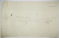
Seething Wells.
[n.d., c.1850?]
Ink sketch map. Sheet 425 x 680mm (16¾ x 26¾"). Tears.
A sketch map of the Brighton Road from near the Thames Ditton Marina to the Fox & Hounds public house at Westfield Road, with Brighton Road (to Surbiton) marked 'From Brighton'. It is possible this was drawn when both Chelsea Water Works and Lambeth Waterworks were about to be relocated to Seething Wells in 1852 after their original sites were declared too polluted to provide drinking water safely.
[Ref: 49013] £160.00

Edwards's General Map of 1400 Square Miles... Also all the Great Roads leading from London to Brighthelmston...
Published as the Act directs, 15 July 1817, by J. Edwards, Obervatory Old Brompton, Middlesex.
Engraved map with original colour. 290 x 600mm, 11½ x 23½". Two folds, as issued.
Uncommon map of the area between London and the south coast of England on a scale of 1:25, orientated with north to the left. Its primary focus is the route from London to Brighton, during the reign of the Prince Regent, with the map designed to also show Windsor Castle. Coastal towns include Eastbourne, Newhaven, Shorham and Worthing. From Edwards' "Tabulæ Distantiæ".
[Ref: 17716] £220.00
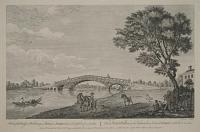
A View of the Bridge at Walton upon Thames in Surry, distance Twenty Miles from London. [Translated into French to right.]
A. Heckel delint. Grignion Sculpt.
Publish'd according to Act of Parliament, 1752. London Printed for & Sold by Robt. Sayer at the Golden Buck opposite Fetter Lane in Fleet Street_ & Henry Overton at the White Horse without Newgate.
Engraving, 260 x 400mm. 10¼ x 15¾". A good impression. Some creasing and tearing in the margins.
The first bridge over the River Thames at Walton-on-Thames, Surrey, here depicted, was constructed between 1748 and 1750, a timber structure that stood until 1783. Canaletto painted a picture of this bridge in 1754. Figures and horses in the foreground, a rower on the river approaching the bridge.
[Ref: 11563] £220.00
(£264.00 incl.VAT)
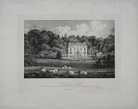
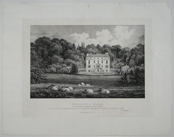
Woodcote Park. The Residence of Baron de Teissier. To whom this View of the East Front is most respectfully inscribed by his obedient and obliged Servant. G.F. Possner.
Printed by Engelmann, G.,C., & Co. [n.d. c.1825.]
Lithograph on india. 241 x 305mm. 9½ x 12". Some water marking.
Woodcote Park, Surrey. A view of the neo-classical manor house with a double curving staircase to the door under a collonaded porch, a long terrace on an arcade stretching to either side. Sheep in the foreground. A fine view of the building which has been home to a Royal Automobile Club club house since 1913. See also ref. 20826 for Woodcote Park.
[Ref: 20825] £80.00
(£96.00 incl.VAT)
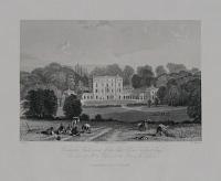
Woodcote Park, seat of the late L. de. Teissier Esq.r Presented by Mrs. de Teisser & the Baron de Teissier.
T. Allom. J.H. Kerton. Eng.d for Brayley's History of Surrey.
Dorking, Published by & for R.B. Ede, 1844.
Engraving. 210 x 280mm. 8¼ x 11". Trimmed, unevenly at top, foxed.
Woodcote Park, Surrey. A view of a neo-classical manor house with a double curving staircase to the door under a collonaded porch, a long terrace on an arcade stretching to either side and culminating in wings; farmers with scythes cutting the grass in the fields, a horse-drawn cart in the middle-ground. The Royal Automobile Club has run a club house at Woodcote Park since 1913. See also ref. 20825 for Woodcote Park
[Ref: 20826] £45.00
(£54.00 incl.VAT)
![[A Room Built by Sir James Burrows on the Castle Bank at Starburgh near Lingfield Surrey.]](jpegs/13297.jpg)