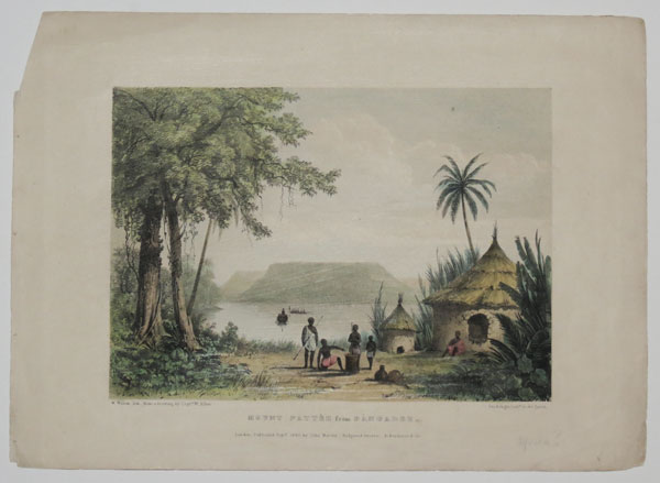
Mount Pattèh from Bàngadeh.
W. Walton, lith. from a drawing by Capt.n W. Allen. Day & Haghw Lith.rs to the Queen.
London, Published Sept.r 1840, by John Murray._ Hodgson & Graves. _ Ackermann & Co.
Coloured lithograph. Printed area 210 x 260mm (8¼ x 10¼").
A view of an riverside settlement in Nigeria, published in Captain William Allen's 'Picturesque views on the river Niger, sketched during Lander's last visit in 1832-33'. Despite Mount Pattèh's distinctive table-top, the location has never been unidentified, although the botanist Vogel described the mountain as being 'near the confluence of the Niger and Benue Rivers, Northern Nigeria'. In 1832 Richard Lander led an expedition to found a trading settlement at the junction of the Niger and Benue rivers. However, the expedition encountered difficulties, including deaths, fever, and Lander was attacked by Africans, receiving a musket ball in his thigh. He managed to return to the coast, but died there from the infected wound. Abbey: Travel 284.
[Ref: 26405] £90.00
(£108.00 incl.VAT)
![[Peace of Algiers] Het afkondigen der Vreede in Algiers, zynde op den 8 Sept: 1726 [...] [parallel texi in Latin]](img-thumbnail/jpegs/59274.jpg)
[Peace of Algiers] Het afkondigen der Vreede in Algiers, zynde op den 8 Sept: 1726 [...] [parallel texi in Latin]
Pet:Schenk exc: Amst: Cum priv. [n.d. c.1730.]
Engraving, sheet 160 x 180mm (6¼ x 7"). Trimmed to plate, folding creases as normal, small tear and wormhole on top edge, some spots.
A scene showing the proclamation of the Peace of Algiers signed between the Regency of Algiers and the Dutch Republic on 8 September 1726, which ended the Dutch-Algerian War (1715-1726).
[Ref: 59274] £75.00
(£90.00 incl.VAT)

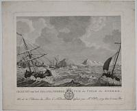
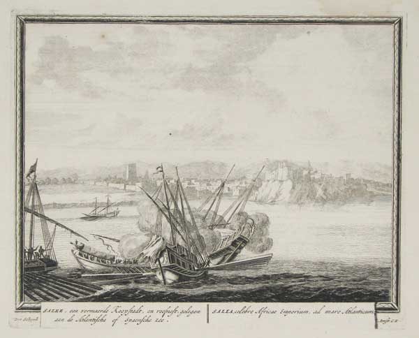
Salee, een vermaerde Koopstadt...
Pet Schenk.
Amst: C.P. [1702.]
Fine engraving, 215 x 265mm. 8½ x 10½".
A maritime battle, one ship in flames, in front of Salé (from the Berber word asla, meaning "rock"), the twin city to Rabat, capital of Morocco. It was a self-governing Republic with international trading influence, situated on the mouth of the Bou Regreg river on the Atlantic coast. Engraved and published in Amsterdam by Pieter Schenk (1660 - 1718/1719). Titles in Dutch, to left, and Latin. Plate to Schenk's 'Hecatompolis' (1702), which included one hundred profile views of cities throughout the world. Hollstein, vol XV, nos.1306-1405.
[Ref: 9755] £180.00
(£216.00 incl.VAT)
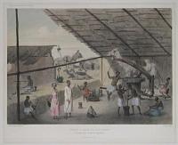
![The Moors gathering Gums. [&] Conveying the Gums to Senegal.](img-thumbnail/jpegs/22655.jpg)
The Moors gathering Gums. [&] Conveying the Gums to Senegal. Durands Voyage [upper right.]
[Anon.]
[London: R. Phillips, 1816.]
Etching and aquatint, two images on a single leaf, sheet 210 x 125mm. 8¼ x 5". Trimmed to plate, scarce.
Illustrating the trade in fruit between Arabs and other North Africans and the Senegalese across the Sahara Desert to the south. The lower image shows a camel train heavily guarded by horsemen with spears. From an English edition of Jean Baptiste Léonard Durand's 'Voyage au Senegal': 'A Voyage to Senegal; or, Historical, Philosophical, and Political Memoirs, Relative to the Discoveries, Establishments, and Commerce of Europeans in the Atlantic Ocean, from Cape Blanco to the River of Sierra Leone'. Durand was a director of the commercial 'Compagnie du Sénégal'.
[Ref: 22655] £120.00
(£144.00 incl.VAT)
![Mr. Durand remettant des instrutions à son envoyé à Galam [...]](img-thumbnail/jpegs/15836.jpg)
Mr. Durand remettant des instrutions à son envoyé à Galam [...]
Dessiné par Seb. Leroy. Gravé par L. Duval
G. B.rd f.me Charost exc. [1802]
Engraving, 170 x 135mm. 6½ x 5¼". Trimmed and glued to backing sheet, slight crease.
Very scarce plate from 'Voyage au Sénégal dans les années 1985 et 1786' by Jean Baptiste Léonard Durand. Here Durand passes over documents for his envoy Rubaud to deliver to the small town of Galam.
[Ref: 15836] £180.00
(£216.00 incl.VAT)

Durand entertaining King Hamet & Family.
[Anon.]
[London: R. Phillips, 1816.]
Etching and aquatint, sheet 210 x 120mm. 8¼ x 4¾". Trimmed to plate at sides.
From an English edition of Jean Baptiste Léonard Durand's 'Voyage au Senegal': 'A Voyage to Senegal; or, Historical, Philosophical, and Political Memoirs, Relative to the Discoveries, Establishments, and Commerce of Europeans in the Atlantic Ocean, from Cape Blanco to the River of Sierra Leone'. Durand was a director of the commercial 'Compagnie du Sénégal', and here hosts a Moorish king on board his ship. Two African slaves bring food to the table, singers playing guitars in the background.
[Ref: 22658] £160.00
(£192.00 incl.VAT)

Negroes Swarming Trees.
[Anon.]
[London: R. Phillips, 1816.]
Etching and aquatint, sheet 210 x 125mm. 8¼ x 5". Trimmed to plate at sides.
Africans climbing palm trees in the traditional manner to reach the fruit at the top. From an English edition of Jean Baptiste Léonard Durand's 'Voyage au Senegal': 'A Voyage to Senegal; or, Historical, Philosophical, and Political Memoirs, Relative to the Discoveries, Establishments, and Commerce of Europeans in the Atlantic Ocean, from Cape Blanco to the River of Sierra Leone'. Durand was a director of the commercial 'Compagnie du Sénégal'.
[Ref: 22661] £130.00
(£156.00 incl.VAT)

View of the Negro Town at Rufisco. View of Cape de Verde. Another View at a distance.
N. Parr sculp.
[London: Thomas Astley, 1745.]
Engraving with large margins. 150 x 215mm (6 x 8½").
A view of Rufiscò, now Rufisque on the Cap Verde peninsula of Senegal, with two coastal profiles of the Cape, with the only named feature being a pair of hills called 'The Breasts'. From John Green's 'A new general collection of voyages and travels; consisting of the most esteemed relations, which have been hitherto published in any language; comprehending everything remarkable in its kind, in Europe, Asia, Africa, and America'.
[Ref: 30237] £120.00
(£144.00 incl.VAT)
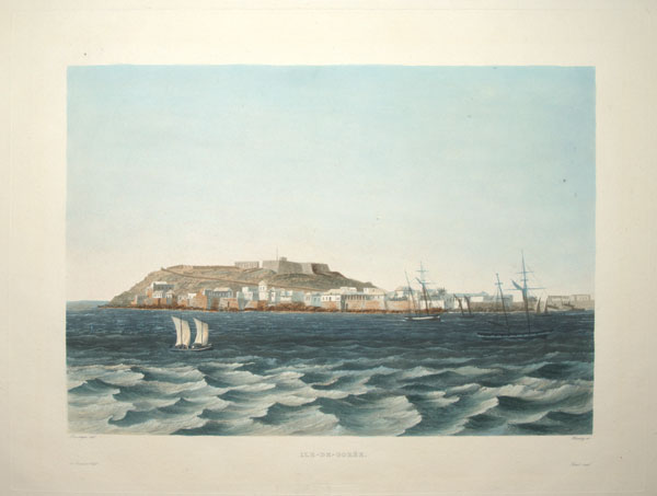
Ile-de-Gorée.
Lauvergne del. Himely sc.
De Sainson Edit. Finot imp. [Paris: Imprimerie Royale, 1833-1835.]
Fine aquatint, printed in colours and hand finished. 290 x 380mm (11½ x 15"), with very large margins, with blindstamp of 'La Favorite'.
A view of French settlement of Île de Gorée, Senegal, famed for its 'Maison des Esclaves' with its 'Door of No Return'. From 'Voyage autour du monde par les mers de l'Inde et de la Chine de la corvette de sa Majeste La Favorite execute pendant les annees 1830, 1831, 1832 sous le commandement de M. Laplace...' (5 vols). Colour-printed examples are rare. SP Lohia Collection 5256: ''The coloured version of the 'Album Historique' is a work of extraordinary quality. It ranks among the finest plate books produced in the 19th century, the colouring being o
[Ref: 54669] £260.00
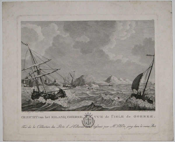
Gezicht van het Eiland, Goeree. Vue de l'Isle de Goeree. Tiré de la Collections des Ports d'Hollande dessinés par M'D'D jong dans le meme port.
Dk de Jong, ad vivum delin. A. Suntach Direxit. No. 12 [Top right].
[n.d. c.1800.]
Copper engraving. Plate 198 x 236mm. 7¾ x 9¼".
Île de Gorée, is an island set away from the main harbour of Dakar. The island is famous for the location of the Maison des esclaves built by an Afro-French Metis family c.1780. The island played a role in the Atlantic slave trade, when slaves were processed or transported from the island fortress. See: NMM: PAF7381. for larger engraving by Sallieth.
[Ref: 16472] £110.00
(£132.00 incl.VAT)

Die Jnsel von Goree im Senegal.
Lith. v.C Buschbeck.
Verlag u Druck v. A. Felgner in Berlin. [n.d. c.1830.]
Coloured lithograph. 349 x 476mm (13¾ x 18¾"). Lithograph of a forge and farrier's shop printed verso.
Naval, sailing and merchant vessels seen on the waters in front of the Island of Gorée, Senegal. The island was one of the first places in Africa to be settled by Europeans, as the Portuguese settled on the Island in 1444; it was then captured by the United Netherlands in 1588, then the Portuguese again, and again the Dutch. It was named after the Dutch island of Goeree and on the hill behind stands the Orange and Nassau Fort. In 1664 the island was taken by the British.
[Ref: 30745] £220.00
(£264.00 incl.VAT)

The Senegal Negro female.
J. Ihle del.t. J.Chapman sculp.t.
Published as the Act directs, Nov.r 15 1794
Engraving, sheet 205 x 115mm (8 x 4½"). Trimmed inside platemark left and right. Messy.
Senegalese woman holding spear; drawn by Johann Ihle for Ebenezer Sibly's five-volume ''Universal System of Natural History'', 1794-6.
[Ref: 45465] £70.00
(£84.00 incl.VAT)

Saint Louis côté du couchant. France Pittoresque.
[E.F. Buttura.]
[n.d. c.1835.]
Engraving. 164 x 222mm. 6½ x 8¾".
Saint Louis was established in 1659 by French traders and it was dedicated to King Louis XIV. This view of the French fort at the mouth of the Senegal River.
[Ref: 20329] £45.00
(£54.00 incl.VAT)
![[The Governor's House, Sierra Leone]](img-thumbnail/jpegs/58035.jpg)
[The Governor's House, Sierra Leone]
JH[?].
[n.d., c.1820.]
Pencil sketch, titled in old ink mss. on reverse. Sheet 190 x 310mm (7½ x 12¼"). Slight mount burn.
A fine sketch of the Governor's House from the sea, with an American ship at anchor. Unfortunately it is unsigned. See Ref: 58036
[Ref: 58035] £320.00

Vue de la Riviere de Sierra-Leone, Sur la cote occidentale de l'Afrique. Du Voyage de Jonh Mathews a ce Continent, en 1785.
Oz. del / Y. Le Gouaz sculp.
A Paris, Chez Noél M.d d'Estampes, Rue St. Jacques, No. 16. [/] et chez Bulla, Rue St. Jacques, No.38. [n.d., c.1795].
Engraving. Platemark: 190 x 230mm (7½ x 9"). Paper toned. Crease to lower left corner.
A view of Sierra Leone, west Africa, from the water. The scene illustrates the voyage of British slave trader John Matthews, as described in his publication titled 'A Voyage to the River Sierra-Leone on the Coast of Africa', first publised in 1788, containing an account of the trade and productions of the country, and of the civil and religious customs and manners of the people. Three vessels can be seen approaching the coast, with more ahead in the distance.
[Ref: 32191] £140.00
(£168.00 incl.VAT)
![Sierra Leone [pencil].](img-thumbnail/jpegs/58036.jpg)
Sierra Leone [pencil].
JH[?].
[n.d., c.1820.]
Pencil sketch. Sheet 190 x 310mm (7½ x 12¼"). Slight mount burn.
A fine sketch, possibly from the Governor's House looking out to sea. Unfortunately it is unsigned. See Ref: 58035
[Ref: 58036] £320.00

Prospect of Bense Island and Fort, from Smith. Bense Island. Negro House at Sierra Leona.
[London: Thomas Astley, 1745.]
A map and two two views of Bunce Island, a British slave fort on the Sierra Leone river, twenty miles upstream from Freetown. Raised about 1670 by the Royal African Company, it was one of the chief suppliers of slaves to the rice industry in the British colonies of South Carolina and Georgia. The banning of the slave trade in 1807 made the fort uneconomic and it was abandoned in 1840. During the negotiations for the Treaty of Paris, ending the American War of Independence in 1783, one of the British delegates was Richard Oswald, one of the owners of Bunce Island; on the American delegation was Henry Laurens, a wealthy rice planter and slave dealer, Bunce Island's business agent in Charleston. From John Green's 'A new general collection of voyages and travels; consisting of the most esteemed relations, which have been hitherto published in any language; comprehending everything remarkable in its kind, in Europe, Asia, Africa, and America'.
[Ref: 30244] £140.00
(£168.00 incl.VAT)
![[Freetown, Sierra Leone.]](img-thumbnail/jpegs/49576.jpg)
[Freetown, Sierra Leone.]
Drawn on Stone by A. Laby & J. Needham after Sketches by Mrs. Terry.
Printed at Mclean Lithographic Establishment, 50 St Martin's Lane. [n.d., c.1850.]
Tinted lithograph with hand colour. Sheet 325 x 755mm (12½ x 29¾"). Tear through title repaired.
A view looking across the bay to Freetown, with European ships anchored. Under the image named features include East Battery, Freetown Church and 'Queen Yard for Lib.d Af.ns'. Laetitia Jervis Terry was the wife of the Assistant Superintendant of the Liberated African's Department. The 'Liberated Africans' were those rescued by the Royal Navy from slave ships destined for the Americas. Over 40,000 liberated Africans arrived in Freetown between 1808 (when Britain abolished the slave trade) and about 1855. Not in Abbey.
[Ref: 49576] £380.00
![[Freetown, Sierra Leone.]](img-thumbnail/jpegs/31430.jpg)
[Freetown, Sierra Leone.]
[Lithographed by A. Laby and J. Needham after Mrs. Terry.]
[London, McLean, c.1850.]
Tinted lithograph with some hand colour. Sheet 325 x 690mm (12½ x 27"). Repaired tears.
A view from above the native village looking out to sea with European ships anchored. Under the image named features are: Murray Point; Mandingo Caravansera Wesleyan Mission House; King Tonis Point; Glen Huntley; Royal Albert. Laetitia Jervis Terry was the wife of the Assistant Superintendant of the Liberated African's Department. The 'Liberated Africans' were those rescued by the Royal Navy from slave ships destined for the Americas. Over 40,000 arrived in Freetown between 1808 (when Britain abolished the slave trade) and about 1855. Not in Abbey.
[Ref: 31430] £480.00

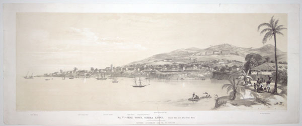
No II. - Free Town, Sierra Leone. South East View.
[Drawn on Stone by A. Laby & J. Needham after Sketches by Mrs. Terry.] Printed at Mclean Lithographic Establishment, 50 St Martin's Lane.
London: Ackermann & Co., 96, Strand [n.d., c.1850.]
Rare tinted lithograph. Sheet 325 x 755mm (12½ x 29¾"), with wide margins.
A view of Freetown with a key noting Government House, Soldiers's Hospital and the Wesleyan Mission House. Laetitia Jervis Terry was the wife of the Assistant Superintendant of the Liberated African's Department. The 'Liberated Africans' were those rescued by the Royal Navy from slave ships destined for the Americas. Over 40,000 liberated Africans arrived in Freetown between 1808 (when Britain abolished the slave trade) and about 1855. Not in Abbey.
[Ref: 52573] £450.00

No V. - Free Town, Sierra Leone. General View from Tom's Point.
Drawn on Stone by A. Laby & J. Needham after Sketches by Mrs. Terry. Printed at Mclean Lithographic Establishment, 50 St Martin's Lane.
London: Ackermann & Co., 96, Strand [n.d., c.1850.]
Rare tinted lithograph with hand colour. Sheet 325 x 755mm (12½ x 29¾"). Tear through title repaired.
A view looking across the bay to Freetown, with European ships anchored. Under the image named features include East Battery, Freetown Church, 'Queen Yard for Lib.d Af.ns', and Wesleyan Institution. Laetitia Jervis Terry was the wife of the Assistant Superintendant of the Liberated African's Department. The 'Liberated Africans' were those rescued by the Royal Navy from slave ships destined for the Americas. Over 40,000 liberated Africans arrived in Freetown between 1808 (when Britain abolished the slave trade) and about 1855. Not in Abbey.
[Ref: 52574] £450.00
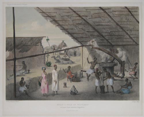
Moulin A Huile En Mouvement et travaux divers executes a Moguedchou.
Arthus Bertrand, editeur. A. Bayot lith.
Imp. Becquet fr.r. des Noyers, 37, Paris. [n.d., c.1860.]
Coloured lithograph, sheet 360 x 425mm. Residue from old mount.
A camel drives a mill in Mogadishu, the capital city of Somalia. 'Voyage a la cote orientale d'Afrique.' printed upper left.
[Ref: 7380] £160.00
(£192.00 incl.VAT)

Voyage au Soudan Oriental. Femmes de Lony (Haut Sennar). retenues captives sur les barques de l'Expédition Egyptienne.
Tremaux del. Laurens et E. David lith.
Imp Lemercier r. de Seine 57 Paris. [n.d., c.1860.]
Hand-coloured lithograph, rare. Sheet: 310 x 425mm (12 x 16¾'') very large margins. Foxing & mount staining.
A wonderful atmospheric scene showing Pierre Tremaux on a riverboat on the Nile observing a group of four African women. From 'Voyages au Soudan oriental et dans l'Afrique septentrionale'.
[Ref: 48048] £340.00
![A Gateway, Tangier. [In pencil below image.]](img-thumbnail/jpegs/42522.jpg)
A Gateway, Tangier. [In pencil below image.]
R. Herdman-Smith. [signed in pencil.]
Etching with hand colour. Limited edition 57/75; original Publishers' label attached. Plate: 215 x 150mm (8½ x 6").
A view of Tangier in Morocco, in which a figure with a lamp approaches through a large gate. Robert Herdman-Smith (1879-1945) was born in Liverpool and exhibited at the Royal Academy and Paris Salon. He taught at the Wellington Technical School, New Zealand, from 1902, later returning to England.
[Ref: 42522] £130.00
(£156.00 incl.VAT)

Divers Prospects in and about Tangier. Prospect of y.e North side of Tangier regarding the mayne Sea from the hill as you come from Whitby or the West, toward the Towne.
Exactly delineated by W: Hollar his May.ties designer, Ao1669, and by him afterwards to satisfie the curious, etchd in Copper.
And are to be Sold by John Overton at the White Horse without Newgate, London 1673.
Etching, sheet 155 x 210mm (6¼ x 8¼"). Trimmed to printed border, mounted in album paper.
Title plate to a series of views in Tangier (modern Morocco) by Wenceslaus Hollar (1607-77). Tangier came into English possession as part of Catherine of Braganza's dowry when she married Charles II in 1662, although attempts to develop it strategically and commercially were unsuccessful. In 1688 Hollar, in his capacity of 'Scenographus Regus', went there as part of a mission sent to deal with problems with hostile natives. Hollar made some sketches of the fortifications, published in 1673. The fortifications shown were demolished in 1684 when the English government abandoned Tangier. Some of Hollar's drawings of Tangier are in the British Museum. Pennington 1187 i/ii. See 41635
[Ref: 42281] £260.00
(£312.00 incl.VAT)

Divers Prospects in and about Tangier. Prospect of y.e North side of Tangier regarding the mayne Sea from the hill as you come from Whitby or the West, toward the Towne.
Exactly delineated by W: Hollar his May.ties designer, Ao1669, and by him afterwards to satisfie the curious, etchd in Copper.
And are to be Sold by John Overton at the White Horse without Newgate, London 1673.
Etching, sheet 155 x 210mm (6¼ x 8¼"). Trimmed to printed border, corners damaged, laid on album sheet.
Title plate to a series of views in Tangier (modern Morocco) by Wenceslaus Hollar (1607-77). Tangier came into English possession as part of Catherine of Braganza's dowry when she married Charles II in 1662, although attempts to develop it strategically and commercially were unsuccessful. In 1688 Hollar, in his capacity of 'Scenographus Regus', went there as part of a mission sent to deal with problems with hostile natives. Hollar made some sketches of the fortifications, published in 1673. The fortifications shown were demolished in 1684 when the English government abandoned Tangier. Some of Hollar's drawings of Tangier are in the British Museum. Pennington 1187 i/ii. See 41635
[Ref: 42672] £120.00
(£144.00 incl.VAT)

Divers Prospects in and about Tangier Exactly delineated by W: Hollar his May.ties designer, A.o 1669, and by him afterwards to satisfie the curious, etchd in Copper. Prospect of ye North side of Tangier regarding the mayne Sea from the hill as you come from Whitby or the West, toward the Towne.
And are to be Sold by John Overton at the White Horse without Newgate, London 1673.
Etching, 17th century watermark, sheet 130 x 215mm (5 x 8½"). Trimmed to image on three sides, small hole in text at bottom.
The title plate to a series of views by Wenceslaus Hollar (1607-77) showing the city when it was an English possession (1671-84). Tangier came into English possession as part of Catherine of Braganza's dowry when she married Charles II in 1662, although attempts to develop it strategically and commercially were unsuccessful. In 1688 Hollar, in his capacity of 'Scenographus Regus', went there as part of a mission sent to deal with problems with hostile natives. Hollar made many sketches of the city (some now in the British Museum), depicting the fortifications that were demolished in 1684 when the English abandoned Tangier. Pennington 1187, state i of ii
[Ref: 55520] £380.00

Prospect of ye Bowling green at Whitehall, by Tangier.
W Hollar delin 1669.
[Published by John Overton, 1673]
Etching, sheet 125 x 215mm (5 x 8½"). Glued to backing sheet.
Bowls being played on a bowling green in British-administered Tangier. One of series of views in Tangier (modern Morocco) by Wenceslaus Hollar (1607-77). Tangier came into English possession as part of Catherine of Braganza's dowry when she married Charles II in 1662, although attempts to develop it strategically and commercially were unsuccessful. In 1688 Hollar, in his capacity of 'Scenographus Regus', went there as part of a mission sent to deal with problems with hostile natives. Hollar made some sketches of the fortifications, published in 1673. The fortifications shown were demolished in 1684 when the English government abandoned Tangier. Some of Hollar's drawings of Tangier are in the British Museum. Pennington 1198 ii/ii
[Ref: 42209] £190.00
(£228.00 incl.VAT)

Tangier.
D Donald.
[British, c.1923.]
Etching, printed in colours, signed artist's proof on vellum. 230 x 325mm (9 x 12¾"), with Fine Art Trade Guild blindstamps.
Boats in the harbour at Tangier, northern Morocco, North Africa; buildings beyond. Guichard: Appendix 1, p.71.
[Ref: 53257] £120.00
(£144.00 incl.VAT)

Prospect of the grounds about Henrietta Fort.
W. Hollar delin.
[Published by John Overton, 1673]
Etching, sheet 125 x 220mm (5 x 8½").
One of series of views in Tangier (modern Morocco) by Wenceslaus Hollar (1607-77). Tangier came into English possession as part of Catherine of Braganza's dowry when she married Charles II in 1662, although attempts to develop it strategically and commercially were unsuccessful. In 1688 Hollar, in his capacity of 'Scenographus Regus', went there as part of a mission sent to deal with problems with hostile natives. Hollar made some sketches of the fortifications, published in 1673. The fortifications shown were demolished in 1684 when the English government abandoned Tangier. Some of Hollar's drawings of Tangier are in the British Museum. Pennington 1197
[Ref: 42207] £190.00
(£228.00 incl.VAT)

Prospect of ye Inner part of Tangier with the upper Castle from South-East.
W. Hollar delineavit et scul.
[Published by John Overton, 1673]
Etching, sheet 125 x 210mm (5 x 8¼"). Trimmed to printed border, laid on paper, some peeled, and mounted in another album sheet.
One of series of views in Tangier (modern Morocco) by Wenceslaus Hollar (1607-77). Tangier came into English possession as part of Catherine of Braganza's dowry when she married Charles II in 1662, although attempts to develop it strategically and commercially were unsuccessful. In 1688 Hollar, in his capacity of 'Scenographus Regus', went there as part of a mission sent to deal with problems with hostile natives. Hollar made some sketches of the fortifications, published in 1673. The fortifications shown were demolished in 1684 when the English government abandoned Tangier. Some of Hollar's drawings of Tangier are in the British Museum. Pennington 1192 ii/ii. See 41636.
[Ref: 42282] £160.00
(£192.00 incl.VAT)

Prospect of ye Inner part of Tangier with the upper Castle from South-East.
W. Hollar delineavit et scul.
[Published by John Overton, 1673]
Etching, sheet 125 x 215mm (5 x 8½"). Trimmed to printed border, laid on album sheet.
One of series of views in Tangier (modern Morocco) by Wenceslaus Hollar (1607-77). Tangier came into English possession as part of Catherine of Braganza's dowry when she married Charles II in 1662, although attempts to develop it strategically and commercially were unsuccessful. In 1688 Hollar, in his capacity of 'Scenographus Regus', went there as part of a mission sent to deal with problems with hostile natives. Hollar made some sketches of the fortifications, published in 1673. The fortifications shown were demolished in 1684 when the English government abandoned Tangier. Some of Hollar's drawings of Tangier are in the British Museum. Pennington 1192 ii/ii. See 41636.
[Ref: 42676] £190.00
(£228.00 incl.VAT)

Prospect of ye Inner part of Tangier with the upper Castle from South-East.
W. Hollar delineavit et scul.
[Published by John Overton, 1673.]
Etching, 17th century watermark, Sheet 125 x 210mm (5 x 8¼"). Trimmed to printed border, tape on reverse.
A view looking up to the citadel of Tangier, one of a series of views by Wenceslaus Hollar (1607-77) showing the city when it was an English possession (1671-84). Frontis to "Moores baffled being a discourse concerning Tangier". Tangier came into English possession as part of Catherine of Braganza's dowry when she married Charles II in 1662, although attempts to develop it strategically and commercially were unsuccessful. In 1688 Hollar, in his capacity of 'Scenographus Regus', went there as part of a mission sent to deal with problems with hostile natives. Hollar made many sketches of the city (some now in the British Museum), depicting the fortifications that were demolished in 1684 when the English abandoned Tangier. Pennington 1192, state i/ii.
[Ref: 55505] £360.00

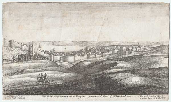
Prospect of ye lower part of Tangier from the hill West of White-hall.
W. Hollar delin.
[Published by John Overton, 1673.]
Etching, 17th century watermark. Sheet 125 x 215mm (5 x 8½"). Some spotting and creasing
A view looking over Tangier towards the bay with the city walls, one of a series of views by Wenceslaus Hollar (1607-77) showing the city when it was an English possession (1671-84). Tangier came into English possession as part of Catherine of Braganza's dowry when she married Charles II in 1662, although attempts to develop it strategically and commercially were unsuccessful. In 1688 Hollar, in his capacity of 'Scenographus Regus', went there as part of a mission sent to deal with problems with hostile natives. Hollar made many sketches of the city (some now in the British Museum), depicting the fortifications that were demolished in 1684 when the English abandoned Tangier. Pennington 1190, state i of ii.
[Ref: 55507] £230.00
(£276.00 incl.VAT)

A Prospect of ye lower part of Tangier from the hill West of White Hall
John Oliver Fecit.
John Sellers Excudit [1680]
Etching, 140 x 215mm. 5½ x 8½".
View of Tangier, from a series of six Tangiers views after Wenceslaus Hollar engraved by John Oliver and published by John Seller in his 'A Book of Sea Stories and Prospects' (1680). Seller (fl. 1660- d.1697) was also an important instrument maker, map and chart seller, and hydrographer to the king.
[Ref: 15898] £140.00
(£168.00 incl.VAT)

Prospect of ye lower part of Tangier from the hill West of White-hall.
W. Hollar delin.
[Published by John Overton, 1673.]
Etching. 120 x 210mm (4¾ x 8¼"). Trimmed, laid on album sheet.
One of series of views in Tangier (modern Morocco) by Wenceslaus Hollar (1607-77). Tangier came into English possession as part of Catherine of Braganza's dowry when she married Charles II in 1662, although attempts to develop it strategically and commercially were unsuccessful. In 1688 Hollar, in his capacity of 'Scenographus Regus', went there as part of a mission sent to deal with problems with hostile natives. Hollar made some sketches of the fortifications, published in 1673. The fortifications shown were demolished in 1684 when the English government abandoned Tangier. Some of Hollar's drawings of Tangier are in the British Museum. Pennington 1190 ii/ii.
[Ref: 42673] £360.00

Prospec of ye North side of Tangier regarding the mayne Sea from the hill as you come from Whitby or the West toward the Torone,
J. Oliver Fecit.
J. Seller Excudit [1680]
Etching, 140 x 215mm. 5½ x 8½".
View of Tangier, from a series of six after Wenceslaus Hollar engraved by John Oliver and published by John Seller in his 'A Book of Sea Stories and Prospects' (1680). Seller (fl. 1660- d.1697) was also an important instrument maker, map and chart seller, and hydrographer to the king.
[Ref: 15895] £140.00
(£168.00 incl.VAT)

The South-East Corner of Tangier, etc.
W. Hollar fecit.
[Published by John Overton, 1673.]
Etching, 17th century watermark. Sheet 125 x 215mm (5 x 8½"). Trimmed, tear in top left corner taped.
A view of the fortifications of Tangier, one of a series of views by Wenceslaus Hollar (1607-77) showing the city when it was an English possession (1671-84). Tangier came into English possession as part of Catherine of Braganza's dowry when she married Charles II in 1662, although attempts to develop it strategically and commercially were unsuccessful. In 1688 Hollar, in his capacity of 'Scenographus Regus', went there as part of a mission sent to deal with problems with hostile natives. Hollar made many sketches of the city (some now in the British Museum), depicting the fortifications that were demolished in 1684 when the English abandoned Tangier. Pennington 1188, state ii of iii
[Ref: 55506] £280.00
(£336.00 incl.VAT)

The South East corner of Tangier
J. Oliver Fc.
John Sellers Excudit [1680]
Etching, 140 x 215mm. 5½ x 8½".
View of Tangier showing the bay, port, 'Coast of Spaine' and 'Point of Gibralter', from a series of six Tangier views after Wenceslaus Hollar engraved by John Oliver and published by John Seller in his 'A Book of Sea Stories and Prospects' (1680). Seller (fl. 1660- d.1697) was also an important instrument maker, map and chart seller, and hydrographer to the king. see Pennington 1188 for Hollar's etching
[Ref: 15896] £140.00
(£168.00 incl.VAT)

The South-East Corner of Tangier etc.
W. Hollar fecit
[Published by John Overton, 1673]
Etching, sheet 125 x 215mm (5 x 8½"). Glued to backing sheet.
The fortifications of Tangier, with the bay on the right and men sat smoking in the foreground. One of series of views in Tangier (modern Morocco) by Wenceslaus Hollar (1607-77). Tangier came into English possession as part of Catherine of Braganza's dowry when she married Charles II in 1662, although attempts to develop it strategically and commercially were unsuccessful. In 1688 Hollar, in his capacity of 'Scenographus Regus', went there as part of a mission sent to deal with problems with hostile natives. Hollar made some sketches of the fortifications, published in 1673. The fortifications shown were demolished in 1684 when the English government abandoned Tangier. Some of Hollar's drawings of Tangier are in the British Museum. Pennington 1188 iii/iii
[Ref: 42213] £190.00
(£228.00 incl.VAT)

The South-East Corner of Tangier, etc.
W. Hollar fecit.
[Published by John Overton, 1673]
Etching, sheet 125 x 215mm (5 x 8½"). Trimmed and laid on album sheet.
The fortifications of Tangier, with the bay on the right and men sat smoking in the foreground. One of series of views in Tangier (modern Morocco) by Wenceslaus Hollar (1607-77). Tangier came into English possession as part of Catherine of Braganza's dowry when she married Charles II in 1662, although attempts to develop it strategically and commercially were unsuccessful. In 1688 Hollar, in his capacity of 'Scenographus Regus', went there as part of a mission sent to deal with problems with hostile natives. Hollar made some sketches of the fortifications, published in 1673. The fortifications shown were demolished in 1684 when the English government abandoned Tangier. Some of Hollar's drawings of Tangier are in the British Museum. Pennington 1188 iii/iii
[Ref: 42675] £190.00
(£228.00 incl.VAT)
Prospect of Tangier from S. West.
W Hollar delineavit et sculp:
[Published by John Overton, 1673.]
Fine etching. 160 x 455mm (6¼ x 18"), with LVG 17th century watermark. Pinhole in image, vertical centre fold, creasing top right corner. Bit messy right margin.
A view of Tangier, with an 18-point key, one of the largest of a series of views by Wenceslaus Hollar (1607-77) showing the city when it was an English possession (1671-84). The watermark is that of Lubertus van Gerrevink, a paper mill in Egmond a/d Hoef, a major Dutch paper manufacturer in the C18th. Tangier came into English possession as part of Catherine of Braganza's dowry when she married Charles II in 1662, although attempts to develop it strategically and commercially were unsuccessful. In 1688 Hollar, in his capacity of 'Scenographus Regus', went there as part of a mission sent to deal with problems with hostile natives. Hollar made many sketches of the city (some now in the British Museum), depicting the fortifications that were demolished in 1684 when the English abandoned Tangier. Pennington 1199, only state.
[Ref: 59120] £550.00

Part of Tangier from above, without the Water-gate.
W Hollar delineavit et sculpsit 1670.
[Published by John Overton, 1673.]
Etching, 17th century watermark, sheet 125 x 215mm (5 x 8½"). Trimmed to image, some spotting and creasing.
A view of Tangier with the partly ruined water-gate on the right and vessels at anchor in the bay, one of a series of views by Wenceslaus Hollar (1607-77) showing the city when it was an English possession (1671-84). Tangier came into English possession as part of Catherine of Braganza's dowry when she married Charles II in 1662, although attempts to develop it strategically and commercially were unsuccessful. In 1688 Hollar, in his capacity of 'Scenographus Regus', went there as part of a mission sent to deal with problems with hostile natives. Hollar made many sketches of the city (some now in the British Museum), depicting the fortifications that were demolished in 1684 when the English abandoned Tangier. Pennington 1189, state ii of iii.
[Ref: 55521] £230.00
(£276.00 incl.VAT)

Part of Tangier from above, without the Water-gate.
W Hollar delineavit et sculpsit 1670
[Published by John Overton, 1673]
Etching, sheet 125 x 215mm (5 x 8½"). Glued to backing sheet.
View of Tangier with the partly ruined water-gate on the right and vessels at anchor in the bay. One of series of views in Tangier (modern Morocco) by Wenceslaus Hollar (1607-77). Tangier came into English possession as part of Catherine of Braganza's dowry when she married Charles II in 1662, although attempts to develop it strategically and commercially were unsuccessful. In 1688 Hollar, in his capacity of 'Scenographus Regus', went there as part of a mission sent to deal with problems with hostile natives. Hollar made some sketches of the fortifications, published in 1673. The fortifications shown were demolished in 1684 when the English government abandoned Tangier. Some of Hollar's drawings of Tangier are in the British Museum. Pennington 1189 ii/iii
[Ref: 42212] £190.00
(£228.00 incl.VAT)

Prospect of the West Side of Yorke Castle at Tangier right opposite to ye upper Castle, taken from the hill before the gate 1669
[Wenceslaus Hollar]
[Published by John Overton, 1673]
Etching, sheet 125 x 215mm (5 x 8½").
One of series of views in Tangier (modern Morocco) by Wenceslaus Hollar (1607-77). Tangier came into English possession as part of Catherine of Braganza's dowry when she married Charles II in 1662, although attempts to develop it strategically and commercially were unsuccessful. In 1688 Hollar, in his capacity of 'Scenographus Regus', went there as part of a mission sent to deal with problems with hostile natives. Hollar made some sketches of the fortifications, published in 1673. The fortifications shown were demolished in 1684 when the English government abandoned Tangier. Some of Hollar's drawings of Tangier are in the British Museum. Pennington 1196 ii/ii
[Ref: 42206] £190.00
(£228.00 incl.VAT)

Prospect of the West Front, of Tangier Castle,
W. Hollar delin.
[Published by John Overton, 1673]
Etching, sheet 125 x 215mm (5 x 8½").
One of series of views in Tangier (modern Morocco) by Wenceslaus Hollar (1607-77). Tangier came into English possession as part of Catherine of Braganza's dowry when she married Charles II in 1662, although attempts to develop it strategically and commercially were unsuccessful. In 1688 Hollar, in his capacity of 'Scenographus Regus', went there as part of a mission sent to deal with problems with hostile natives. Hollar made some sketches of the fortifications, published in 1673. The fortifications shown were demolished in 1684 when the English government abandoned Tangier. Some of Hollar's drawings of Tangier are in the British Museum. Pennington 1194
[Ref: 42208] £190.00
(£228.00 incl.VAT)

Prospect of Yorke Castle at Tangier, from ye Strand, and the North-West.
W Hollar delin: et sculp:
[Published by John Overton, 1673]
Etching, sheet 125 x 215mm (5 x 8½"). Glued to backing sheet.
Loaded carts drawn by horses travelling in front of York Castle in Tangier. One of series of views in Tangier (modern Morocco) by Wenceslaus Hollar (1607-77). Tangier came into English possession as part of Catherine of Braganza's dowry when she married Charles II in 1662, although attempts to develop it strategically and commercially were unsuccessful. In 1688 Hollar, in his capacity of 'Scenographus Regus', went there as part of a mission sent to deal with problems with hostile natives. Hollar made some sketches of the fortifications, published in 1673. The fortifications shown were demolished in 1684 when the English government abandoned Tangier. Some of Hollar's drawings of Tangier are in the British Museum. Pennington 1198 ii/ii
[Ref: 42210] £190.00
(£228.00 incl.VAT)

Prospect of Yorke Castle at Tangier, from ye Strand, and the North-West.
W Hollar delin: et sculps:
[Published by John Overton, 1673.]
Etching, 17th century watermark. Sheet 125 x 215mm (5 x 8½"). Trimmed to printed border, tear in top left corner taped.
A view of the citadel of Tangier, with carts loaded with stone, probably for rebuilding the defences of the city, one of a series of views by Wenceslaus Hollar (1607-77) showing the city when it was an English possession (1671-84). Tangier came into English possession as part of Catherine of Braganza's dowry when she married Charles II in 1662, although attempts to develop it strategically and commercially were unsuccessful. In 1688 Hollar, in his capacity of 'Scenographus Regus', went there as part of a mission sent to deal with problems with hostile natives. Hollar made many sketches of the city (some now in the British Museum), depicting the fortifications that were demolished in 1684 when the English abandoned Tangier. Pennington 1198, state i of ii.
[Ref: 55508] £240.00
(£288.00 incl.VAT)

Prospect of Yorke Castle at Tangier, from ye Strand, and the North-West.
W Hollar delin: et sculps:
[Published by John Overton, 1673]
Etching, sheet 125 x 215mm (5 x 8½"). Trimmed to printed border, laid on album sheet.
Loaded carts drawn by horses travelling in front of York Castle in Tangier. One of series of views in Tangier (modern Morocco) by Wenceslaus Hollar (1607-77). Tangier came into English possession as part of Catherine of Braganza's dowry when she married Charles II in 1662, although attempts to develop it strategically and commercially were unsuccessful. In 1688 Hollar, in his capacity of 'Scenographus Regus', went there as part of a mission sent to deal with problems with hostile natives. Hollar made some sketches of the fortifications, published in 1673. The fortifications shown were demolished in 1684 when the English government abandoned Tangier. Some of Hollar's drawings of Tangier are in the British Museum. Pennington 1198 ii/ii.
[Ref: 42677] £190.00
(£228.00 incl.VAT)
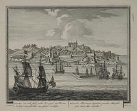
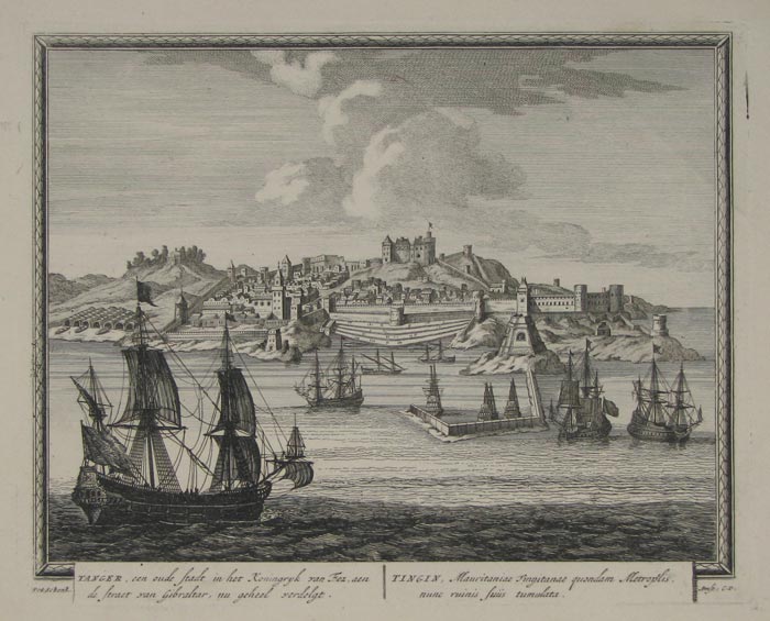
Tanger, een oude stadt in het Koningryk van Eez, aen de straet van Gibraltar...
Pet: Schenk.
Amst: C.P. [n.d., c.1702.]
Fine engraving, 215 x 270mm. 8½ x 10½".
A panorama with ships in the foreground of Tangier or Tangiers in northern Morocco. It lies on the North African coast at the western entrance to the Strait of Gibraltar, where the Mediterranean meets the Atlantic Ocean. Engraved and published in Amsterdam by Pieter Schenk (1660 - 1718/1719). Titles in Dutch, to left, and Latin. Plate to Schenk's 'Hecatompolis' (1702), which included one hundred profile views of cities throughout the world. Hollstein, vol XV, nos.1306-1405.
[Ref: 9754] £220.00
(£264.00 incl.VAT)
![[Peace of Algiers] Het afkondigen der Vreede in Algiers, zynde op den 8 Sept: 1726 [...] [parallel texi in Latin]](jpegs/59274.jpg)
![The Moors gathering Gums. [&] Conveying the Gums to Senegal.](jpegs/22655.jpg)
![Mr. Durand remettant des instrutions à son envoyé à Galam [...]](jpegs/15836.jpg)


![[The Governor's House, Sierra Leone]](jpegs/58035.jpg)

![Sierra Leone [pencil].](jpegs/58036.jpg)

![[Freetown, Sierra Leone.]](jpegs/49576.jpg)
![[Freetown, Sierra Leone.]](jpegs/31430.jpg)


![A Gateway, Tangier. [In pencil below image.]](jpegs/42522.jpg)