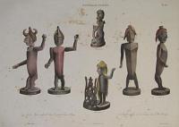
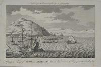
Nouvelle Guinée.
de Sainson pinx. et lith.
J. Tastu Editeur. Lith. de Lemercier. [Paris, 1833.]
Colour lithograph. Printed area 280 x 380mm. Some foxing on print.
This print depicts figures found in a place of worship in Dorey, New Guinea, and funerary figures from Masmapi. From 'Voyage de la Corvette l'Astrolabe', the account of Jules Dumont D'Urville's important expedition to the South Seas between 1826 and 1829.
[Ref: 8186] £130.00
(£156.00 incl.VAT)
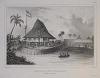
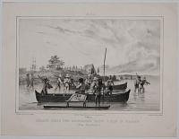
Maison de l'Agent Hollandais. à Tondano. (Iles Celèbes.)
de Sainson pinx. V. Adam Lith.
J. Tastu, Editeur. Lith. de Lemercier. [Paris, 1833.]
Lithograph. Printed area 280 x 350mm.
A view of a building in Tonando, in the Celebes, then governed by the Dutch. From 'Voyage de la Corvette l'Astrolabe', the account of Jules Dumont D'Urville's important expedition to the South Seas between 1826 and 1829.
[Ref: 8161] £190.00
(£228.00 incl.VAT)
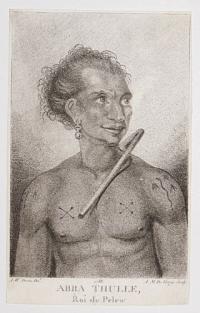
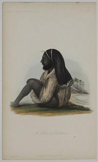
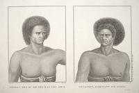
Abba Thulle, Roi de Pelew.
A.W. Devis Del. A.M.De Gouy Sculp.
A rare stipple. Sheet: 170 x 105mm (6¾ x 4¼"). Trimmed. Slight repaired tear in title.
Captain Henry Wilson when he stayed in the Palau Islands, now known as Belau, after the shipwreck of his East India Company packet Antelope. Wilson and his crew became friendly with the Palauans, especially the high chief of Koror, the ibedul, known by the crew as Abba Thule. Abba Thule's second son, Prince Lee Boo, was chosen to sail to England with the crew. They left the islands on 12 November 1783. Lee Boo survived only six months in England. He died of smallpox and was buried in the churchyard of St Mary's, Rotherhithe, where his grave can still be seen.
[Ref: 46688] £230.00
(£276.00 incl.VAT)
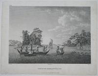
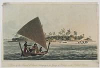
View of the Admiralty Islands. No. II.
Piron del. Harding ex. Angus sc.
Published Apr. 20 1800 by J. Debrett Piccadilly.
Engraving. 222 x 291mm. 8¾ x 11½".
Natives fishing in tbe bay outside the Admiralty Islands, Papua New Guinea. From the English edition of Jacques Labillardière's ''An Account of A Voyage in search of La Perouse... Under the Command of Rear-Admiral Bruni d'Entrecasteaux'', an expedition that crossed the South Pacific, visiting Australia, New Zealand and the East Indies between 1791-3.
[Ref: 20743] £110.00
(£132.00 incl.VAT)

Vue des Îsles de L'Amirauté
Piron del. Dien scripsit. Imprimée chez Dien.
[Paris: H.J.Jansen, 1800.]
Engraving. 310 x 440mm (12¼ x 17¼").
View in the Admiralty Islands, in the Manus Province of Papua New Guinea, with locals spear-fishing from canoes. In 1788 Jean-Francois de Galaup, comte de La Pérouse set sail from Botany Bay and was never seen again. Despite the upheaval of the French Revolution the National Assembly was moved to send an expedition in search of their lost hero, 1791-3, under Chevalier Bruni d'Entrecasteaux. Despite finding no trace of La Perouse, losing its commander and many crew to scurvy, and finally splitting between royalist and republican factions, the expedition was judged a success because of the important observations made by the expedition's scientists, especially in Australia. This account, compiled by the expedition's botanist, Jacques Julien Houtou de Labillardière, was published as 'Relation du voyage à la recherche de La Pérouse', with natural history plates by Redouté and Audebert. The work even has its own abbreviation in botantical literature, 'Voy.Rech.Perouse'. Ex Collection Norman Blackburn.
[Ref: 18696] £550.00
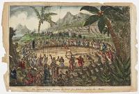
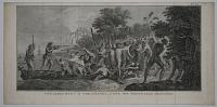
The extraordinary Manner of the Trial for Adultery, among the Malays.
[William Elmes.]
[London Pub. by T. Tegg, Oct. 7. 1808.]
Hand-coloured aquatint. Sheet size: 260 x 175mm (10¼ x 7"). Trimmed, creases, edges damaged and paper toned.
A fascinating image from a very scarce series of plates by the caricaturist William Elmes depicting shipwrecks and maritime disasters, attacks by native Americans and by other indigenous peoples and pirates, ceremonies, punishments and torture. Published by Thomas Tegg.
[Ref: 44680] £220.00
(£264.00 incl.VAT)
View of the Island of Airick, belonging to the Group of Kawen, in the Radack Chain.
I. Clark sc.
[n.d., c.1821.]
Hand coloured aquatint. Sheet size: 115 x 175mm (4½ x 6¾"). Trimmed inside platemark. Nick in top left & right corner.
A plate from 'Voyage Of Discovery Into The South Sea And Beering's Straits, For the purpose of exploring a north-east passage, undertaken in the years 1815-1818' by Otto von Kotzebue, 1821. An admirer of Captain Cook, Otto von Kotzebue (17871846) was a leading navigator, in Russian service, circumnavigating the globe three times. His 1815 expedition set out to find a passage through the Arctic, study the coastlines of Kamchatka and Alaska, and explore the Pacific.
[Ref: 37333] £75.00
(£90.00 incl.VAT)
A Native of Anaiteum. Dr. Pritchard's Natural History of Man. Plate XXXVII. Page 471.
London & New York, H. Bailliere, 1855.
Coloured aquatint. 240 x 145mm (9¾ x 5¾").
A native from the island of Aneityum, Vanuata. From 'Natural History of Man' by Dr James Cowles Pritchard.
[Ref: 30263] £80.00
(£96.00 incl.VAT)
![Inauguration du Monument [elevé par l'Astrolabe à lapérouse à Vanikoro.]](img-thumbnail/jpegs/8178.jpg)
Inauguration du Monument [elevé par l'Astrolabe à lapérouse à Vanikoro.]
de Sainson pinxt. Vanderburch Lith. Fig. par V. Adam
[J. Tastu]
Lithograph. Printed area 325 x 470mm (12¾ x 18½"). Trimmed to image top and bottom, losing half of title.
From 'Voyage de la Corvette l'Astrolabe', the account of Jules Dumont D'Urville's important expedition to the South Seas between 1826 and 1829. Here the ship's crew assemble for the inauguration of a monument to La Pérouse in Vanikoro on 14th March, 1828. La Pérouse was a French Navy officer and explorer whose expedition vanished in the Pacific around 1788. A number of expeditions were sent in search of him before Dumont d'Urville found the remains of his ships in the Solomon Islands.
[Ref: 8178] £160.00
(£192.00 incl.VAT)
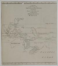
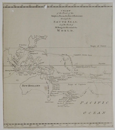
Chart of the Track of the Dolphin, Tamar, Swallow & Endeavour, through the South Seas; & the Track of M. Bougainville, round the World.
[Engraved by Thomas Bowen.]
[London: London Magazine, 1773.
Engraved map. Sheet 260 x 230mm, 13¼ x 9". Two holes, trimmed close, binding folds.
A map of the South Pacific showing the routes of the 18th century explorers including Cook on his First Voyage, in which he mapped New Zeland and the east coast of Australia for the first time. This is one sheet of a three-sheet map: however, as the sheets were published in seperate months in the Gentleman's Magazine, they often appear separately.
[Ref: 25753] £160.00
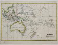
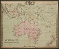
Océeanie. par J.B. Poirson.
Gravé par Thierry, Rue des Mathurins, S. Jacques, No. 1.
[Paris c.1830.]
Engraved map, coloured. 230 x 335mm, 9 x 13¼". Narrow lateral margins.
A map of Australasia showing north to Hawaii and Taiwan, published in the 'Traite Eleméntaire de Géographie'.
[Ref: 25752] £160.00

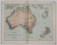
Polynesia and Australasia.
Neele & stockley sc. 352 Strand.
Engraved map. 210 x 260mm, 8¼ x 10¼".
A map of Australasia showing north to Hawaii and Taiwan, published in the 'Encyclopedia Londonensis'.
[Ref: 25751] £80.00
Australien nach Krusenstern u. A. in Mercators Projection entworfen u. ges. v. Ad. St., 1826. Nachträge bis 1835.
I. Thiel sculp.
Engraved map with hand colour. 340 x 400mm, 13½ x 15¾". Slight creasing & foxing.
A German map of Australasia.
[Ref: 25749] £120.00
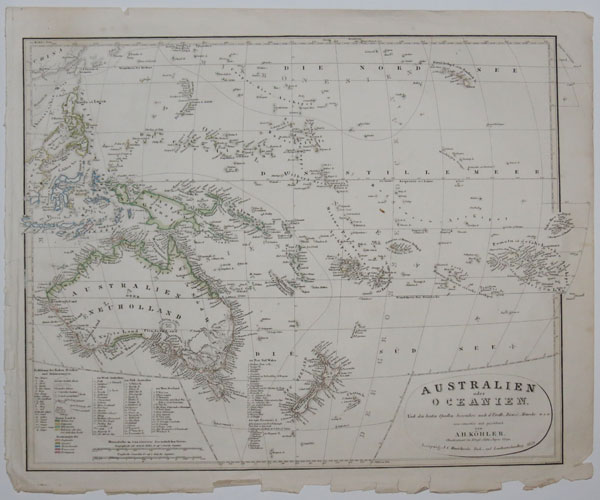
Australien oder Oceanien...
von A.H. Köhler, Oberlieutnant in Königl. Sachs, Jughen. Corps.
Leipsig, J.C. Hinrichs'sche Buch_und Landkärtenhandlung 1849.
Engraved map with hand colour. 410 x 500mm, 16 x 19¾". Tear in bottom printed border, tatty margins.
Map of Australasia marking the European colonies.
[Ref: 25747] £160.00
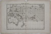
Théorie des Vents.
Gravé par Berthe.
[Paris: veuve Agasse, 1828.]
Engraved map. 265 x 375mm, 10½ x 14¾". Centre fold split and taped.
Map of Australasia and the South Pacific to California, marking the directions of the winds. Published in Bory de Saint-Vincent & Desmarest's 'Atlas encyclopedique contenant les cartes et les planches relatives a la geographie physique'.
[Ref: 25745] £120.00

Australien und Polynesien in Mercator's Projection.
Entworfen und gezeichnet von F. v. Stülpnagel. Berichtigt von A. Petermann. Gestochen v. C. Poppey.
Gotha: Justus Perthes. 1855.
Engraved map with hand colour. 340 x 430mm, 13½ x 17".
Map of Australasia with the colonies of each European counry marked in colour. Published in Stieler's Hand-Atlas.
[Ref: 25672] £140.00
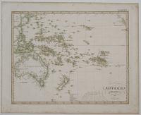
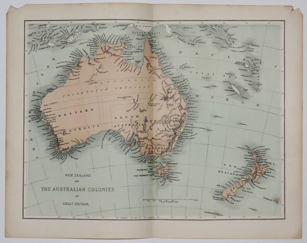
New Zealand and the Australian colonies of Great Britain.
[Virtue & Co., n.d., c.1855.]
Tinted lithographic map. Printed area 230 x 305mm, 9 x 12".
Australia & New Zealand, with much of the Australian interior marked 'unexplored', although the extents of the treks of Sturt (1845) and Kennedy (1847) are shown.
[Ref: 26309] £65.00
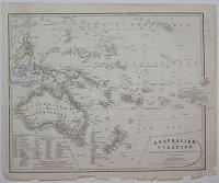
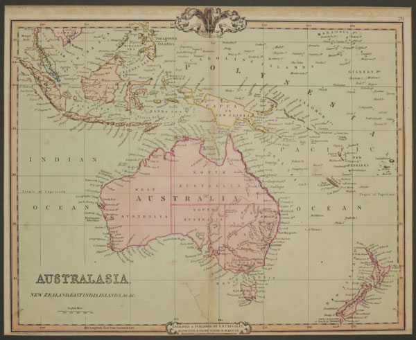
Australasia, New Zealand, East India Islands, &c. &c.
Engraved and Published by G.F. Cruchley, Map Seller and Globe Maker, 81 Fleet Street. April 1st 1842. Additions to 1854.
Engraved map with original hand colour. 370 x 450mm, 14½ x 17¾". Repaired tear.
A map of Australasia, showing Australia and New Zealand, Indonesia, New Caledonia and Fiji.
[Ref: 25658] £180.00
Bougainville, abordant à Taïti, (iles Marquises.)
Rouargue frères del et sc.
[n.d. c.1846.]
Steel engraving. Sheet 146 x 235mm. 5¾" x 9¼".
Comte Louis-Antoine de Bougainville (1729-1811), soldier, sailor. After studying law and mathematics, he published a Traité de calcul intégral (1754-56) and was elected to the Royal Society (London). Having entered the military in 1750, he was posted to Québec in 1756 as aide-de-camp to Montcalm.
[Ref: 9342] £65.00
(£78.00 incl.VAT)
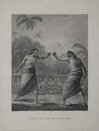
A Boxing Match, in Hapaee.
J.Webber del. I.Taylor sc.
[London, G. Nicol and T. Cadell, 1785.]
Engraving. 300 x 225mm, 11¾ x 8¾".
Two Tongans sparring, with thongs over their knuckles. John Webber (1751-93) travelled with Captain Cook on the Third Voyage (1776-80) as the Official Artist of the expedition, recording the explorer's death at the hand of Hawaiian natives.
[Ref: 11057] £160.00
(£192.00 incl.VAT)

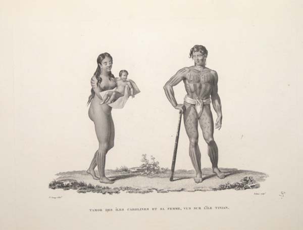
Tamor des Îles Carolines et sa Femme, vus sur l'Ìle Tinian.
J.s Arago delin.t. Lerouge et Chobard sculp.t.
[Paris, 1822-4.]
Stipple. 240 x 320mm (9½ x 12½"), with large margins.
A warrior of the Caroline Islands, dressed in loincloth to show off his body tatoos and carrying a carved club, with his wife and child. Drawn by Jacques Étienne Victor Arago (1790-1855) and published in the official account of Louis-Claude de Freycinet's circumnavigation, 'Voyage Autour Du Monde fait par ordre du roi sur les corvettes de S.M l'Uranie et la Physicienne pendant les années 1817, 1818, 1819 et 1820'.
[Ref: 53636] £230.00
(£276.00 incl.VAT)

A Canoe and Natives of Mulgrave's Range.
R. Cleveley Del.t. T. Medland sculp.t.
Published Oct. 15. 1789 by J. Stockdale.
Engraving. 210 x 255mm (8½ x 10"). Trimmed within plate at top. Small margins on 3 sides. Very slight staining at top, small tear on right.
An outrigger canoe of 'Lord Musgrave's Range', apparently a coral island near the Caroline Islands. From Phillip's 'The voyage of Governor Phillip to Botany Bay', published in London in 1789, although illustrating John Marshall's voyage from Port Jackson to Whampoa in China, also described in the book.
[Ref: 44037] £130.00
(£156.00 incl.VAT)

Îles CarolinesL Dances et Costum des Naururels.
J.s. Arago delin.t. Lerouge et Choubard sculpt.
[Paris, 1822-4.]
Stipple. 235 x 320mm (9¼ x 12½"), with wide margins.
Men of the Caroline Islands dancing with staves, under instruction from a man at the side. A plate from the official account of Louis-Claude de Freycinet's circumnavigation, 'Voyage Autour Du Monde fait par ordre du roi sur les corvettes de S.M l'Uranie et la Physicienne pendant les années 1817, 1818, 1819 et 1820'.
[Ref: 54234] £190.00
(£228.00 incl.VAT)
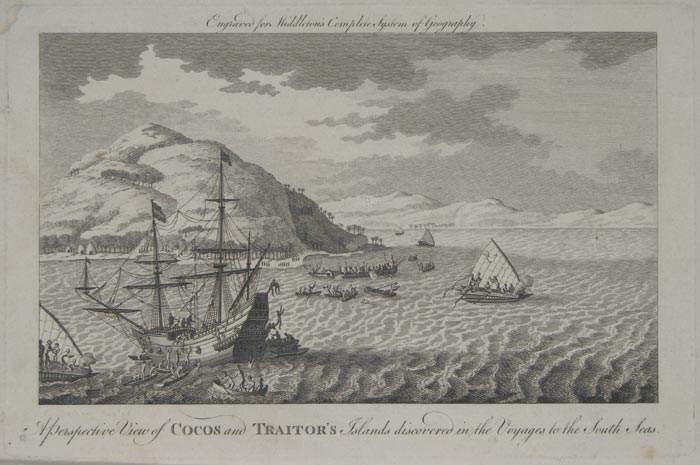
A Perspective View of Cocos and Traitor's Islands discovered in the Voyages to the South Seas.
F. Chesham Sculpt. Engraved for Middleton's Complete System of Geography.
[n.d., c.1777.]
Etching and engraving, 190 x 290mm. 7½ x 11½". Two pin holes to image. Repaired hole to title area.
A European ship's crew is attacked by inhabitants of Tafahi and Niuatoputapu, two islands of the kingdom of Tonga. Plate to Charles Theodore Middleton's 'A new and complete system of Geography ... Embellished ... with ... copper plates, etc.', London 1777-78.
[Ref: 9660] £70.00
(£84.00 incl.VAT)
Débarquement a Erramanga, L'une des Nouvelles Hébrides.
Benard Direx [after William Hodges].
[Paris, Saillant et Nyon & Panckouke, c.1777.]
Engraving. 240 x 280mm, 9½ x 19". Tear in margin, original binding folds.
The landing at Eromanga, one of the New Hebrides or Vanutu, showing the Captain Cook's crew battling with native warriors in 1774. The original picture was painted by William Hodges (1744-97), the official artist on Cook's second circumnavigation. This example was published in a French edition of the Official Account of Cook's Second Voyage.
[Ref: 18799] £220.00
(£264.00 incl.VAT)
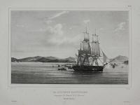
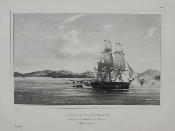
La Corvette l'Astrolabe, attaquée par les Naturels de la Côte nord. (Nouvelle Guinée.) Pl.III.
de Sainson pinx. A. St. Aulaire Lith.
J. Tastu, Editeur. Lith. de Lemercier. [Paris, 1833.]
Lithograph with very large margins. Sheet 342 x 508mm (13½ x 20"). Spotting in the margins; publisher's blindstamp under title.
The French ship 'Astrolabe' under attack from the natives of New Guinea. From 'Voyage de la Corvette l'Astrolabe', the account of Jules Dumont D'Urville's important expedition to the South Seas between 1826 and 1829.
[Ref: 28206] £160.00
(£192.00 incl.VAT)
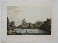
View of the Harbour of Taloo, in the Island of Eimeo.
J. Webber fecit.
London Pub.d April 1. 1809 by Boydell & Comp.y No. 90 Cheapside.
Aquatint with large margins and very fine hand colour. Platemark: 325 x 450mm (12¾ x 17½"). Repairs to sheet including an area inside the printed area to the bottom left, stain in printed area to the left.
A landscape with several small vessels and canoes on a lake, surrounded by steep, craggy mountains covered with trees. Three figures can be seen on the shore in the left foreground, where boats are putting in. John Webber was the official artist on Cook's final voyage through the Pacific; his drawings formed the basis for printed illustrations to the account of 'A Voyage to the Pacific', published in 1784. Vide Cook's last Voyage Vol II. Chap. V.
[Ref: 31818] £420.00
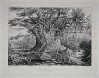
Figuier Gigantesque a Nouka-Hiva (Baie Anna Maria.) Voyage au pôle Sud et dans l'Océanie. Atlas Pittoresque Pl.53.
Dessiné par L.Le Breton. Lith.é par De La Plante.
Gide Editeur. Lith. de Thierry frères à Paris. [n.d. c.1846.]
Lithograph and etching. 305 x 387mm. 12 x 15¼". Some spotting.
A giant fig tree in Nuka Hiva, French Polynesia. From 'Voyage au pôle Sud et dans l'Océanie sur les corvettes l'Astrolabe et la Zélée 1837-1840', the account of Jules Dumont D'Urville's second expedition to the South Seas. The 31 volumes took 14 years to publish, not helped by D'Urville's death in the famous Versailles Rail Accident of 1842, the first French railway disaster. Publisher's blindstamp below title. NLA: 2994241. Ex Norman Blackburn Collection.
[Ref: 18856] £160.00
(£192.00 incl.VAT)
![[Fiji] Vah-Ta-Ah. The Feejeean Princess.](img-thumbnail/jpegs/46767.jpg)
[Fiji] Vah-Ta-Ah. The Feejeean Princess.
From a Miniature by J.D. Macdonald, of H.M.S. Herald.
Printed in Oil Colours By Baxter, Inventor and Patentee, London.
Engraving. 93 x 105mm.
'This is an illustration from [Joseph] Waterhouse's book "Vah-ta-ah". This primitive native was a cruel and vicious cannibal but later was baptised and re-christened "Lydia"' (Ball & Martin, 'The Price Guide to Baxter Prints').
[Ref: 46767] £50.00
(£60.00 incl.VAT)
Toubau, Fils du Roi des Îles des Amis. Vouacécé, Habitant de Fidgi. Atlas du Voyage à la recherche de la Pérouse. No 29.
Piron delin. Copia sculp. Dien Scripsit.
[Paris: H.J.Jansen, 1800.]
Engraving. 305 x 445mm (12 x 17½").
Two portraits: Toubau, son of the King of the Friendly Isles, and Vouacécé, a man of Fiji who the French met in Tongatapu, 150 leagues away. In 1788 Jean-Francois de Galaup, comte de La Pérouse set sail from Botany Bay and was never seen again. Despite the upheaval of the French Revolution the National Assembly was moved to send an expedition in search of their lost hero, 1791-3, under Chevalier Bruni d'Entrecasteaux. Despite finding no trace of La Perouse, losing its commander and many crew to scurvy, and finally splitting between royalist and republican factions, the expedition was judged a success because of the important observations made by the expedition's scientists, especially in Australia. This account, compiled by the expedition's botanist, Jacques Julien Houtou de Labillardière, was published as 'Relation du voyage à la recherche de La Pérouse', with natural history plates by Redouté and Audebert. The work even has its own abbreviation in botantical literature, 'Voy.Rech.Perouse'.
[Ref: 52622] £150.00
(£180.00 incl.VAT)
![[Oceania] Flicka Pa Tahiti.](img-thumbnail/jpegs/11397.jpg)
[Oceania] Flicka Pa Tahiti.
C.S. del. Fargtryck af J.F. Meyer & Co. I Stockholm.
[n.d., c.1860s.]
Chromolithograph, sheet 225 x 140mm. 8¾ x 5½". Some spotting.
A woman of Tahiti in the South Pacific Ocean. Plate to a book.
[Ref: 11397] £75.00
(£90.00 incl.VAT)
Double Canoe of the Friendly Islands. No. XXVIII.
Piron del. Harding ex. Taylor sc.
Pud. Apr. 20, 1800 by J. Debrett Piccadilly.
Engraving. 228 x 291mm (9 x 11½").
A Tongan double pirogue (flat-bottomed boat) with a platform. Tonga was named the Friendly Islands by Cook because of his reception there. From the English edition of Jacques Labillardière's ''An Account of A Voyage in search of La Perouse... Under the Command of Rear-Admiral Bruni d'Entrecasteaux'', an expedition that crossed the South Pacific, visiting Australia, New Zealand and the East Indies between 1791-3. See Ref: 18693 for French publication.
[Ref: 20738] £130.00
(£156.00 incl.VAT)

A Dance at the Friendly Islands in Presence of Queen Tineh. No. XXVII.
Piron del. Harding ex. Birrell sc.
[n.d. c.1800.]
Copper engraving. 229 x 292mm. 9 x 11½". Trimmed, with foxing.
Women dancing for Queen Tine on the Island of Tonga, named the Friendly Islands by Captain Cook. From "An Account of A Voyage in search of La Perouse...Under the Command of Rear-Admiral Bruni d'Entrecasteaux'.
[Ref: 20740] £130.00
(£156.00 incl.VAT)

Double Canoe of the Friendly Islands. No. XXVIII.
Piron del. Harding ex. Taylor sc.
Pub.d Apr. 20, 1800 by J. Debrett Piccadilly.
Engraving, sheet 230 x 305mm (9 x 12"). Trimmed to plate.
A Tongan double pirogue (flat-bottomed boat) with a platform with topless ladies entertaining Admiral Bruni. Tonga was named the Friendly Islands by Cook because of his reception there. From the English edition of Jacques Labillardière's ''An Account of A Voyage in search of La Perouse... Under the Command of Rear-Admiral Bruni d'Entrecasteaux'', an expedition that crossed the South Pacific, visiting Australia, New Zealand and the East Indies between 1791-3. See Ref: 18693 for French publication;
[Ref: 32225] £260.00
(£312.00 incl.VAT)

A Dance at the Friendly Islands in Presence of Queen Tineh. No. XXVII.
Piron del. Harding ex. Birrell sc.
Publishd Apr. 20 1800 by J. Debrett Piccadilly
Engraving, sheet 230 x 305mm (9 x 12"). Trimmed to plate; slight foxing.
Topless women dancing for Queen Tine on the Island of Tonga, named the Friendly Islands by Captain Cook. From the English edition of Jacques Labillardière's ''An Account of A Voyage in search of La Perouse... Under the Command of Rear-Admiral Bruni d'Entrecasteaux'', an expedition that crossed the South Pacific, visiting Australia, New Zealand and the East Indies between 1791-3.
[Ref: 32226] £250.00
(£300.00 incl.VAT)
![[Five oval portraits from Cook's Voyages].](img-thumbnail/jpegs/7118.jpg)
[Five oval portraits from Cook's Voyages]. Capt. James Cook, F.R.S. Killed on the Island of Owhyhee, 14th Feb.y 1779. A Man of the Sandwich Islands. A Woman of the Sandwich Islands. A Man of Mangea. Omai of Omia a Native of Ulietea.
Tookey Sculp.
Published Jan 1st 1785 by G. & T. Wilkir, S.t Paul's Church Yard.
Engraving. 250 x 200mm.
Published in Hervey's 'New System of Geography'.
[Ref: 7118] £230.00
(£276.00 incl.VAT)
![[Oceania] Hoaori](img-thumbnail/jpegs/11398.jpg)
[Oceania] Hoaori Hofding r Papituai.
C.S. del. Fargtryck af J.F. Meyer & Co. I Stockholm.
[n.d., c.1860s.]
Chromolithograph, sheet 225 x 140mm. 8¾ x 5½". Some spotting.
A man of Tahiti in the South Pacific Ocean. Plate to a book.
[Ref: 11398] £70.00
(£84.00 incl.VAT)
![[Oceania] Hofding Pa Lefuka.](img-thumbnail/jpegs/11396.jpg)
[Oceania] Hofding Pa Lefuka.
C.S. del. Lith. Jnst. Arnz & Co. Dusseldorf.
[n.d., c.1860s.]
Chromolithograph, sheet 225 x 140mm. 8¾ x 5½". Some spotting.
A man of Tonga in the South Pacific Ocean. Plate to a book published in Dusseldorf, Germany, by lithographic printers Lithographisches Institut von Arnz & Co.
[Ref: 11396] £70.00
(£84.00 incl.VAT)
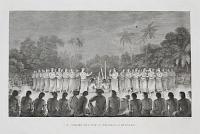
A Night Dance by Women, in Hapaee.
J. Webber del. W.m Sharp sculp.
[London: Nicol & Cadell, n.d., c.1785.]
Engraving with very large margins. Platemark: 270 x 400mm (10½ x 15¾"). Uncut. Edge of top margins, stained. Very slight crease & small foxmark.
A plate from 'Cook's Voyage to the Pacific'. A night scene depicting Tongan women dancing in two rows, on both side of the image, wearing cloth skirts and flower headbands. Behind the women, are a group of men sitting on the ground in a circle, holding wooden musical instruments. An audience of men and women can be seen in the background. Four White officers are depicted in the foreground, watching the performance. John Webber (1751-93) travelled with Captain Cook on the Third Voyage (1776-80) as the Official Artist of the expedition, recording the explorer's death at the hand of Hawaiian natives.
[Ref: 34303] £320.00
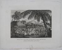
![[Hoorn Islands?]](img-thumbnail/jpegs/53717.jpg)
[Hoorn Islands?]
[after Jacob Le Maire.]
[n.d., c.1620.]
Engraving 195 x 170mm (7¾ x 6¾"), set in text. Some overprinting of letterpress, as usual.
A view of the crew of the 'Eendracht' and 'Hoorn' enjoying the hospitality of islanders, during the circumnavigation of Jacob Le Maire and Willem Schouten, 1615-7. The letterpress overprinting '1616 Majus' suggests the view is of the Hoorn Islands where they rested for three weeks, April 28th - May 12th, 1616.
[Ref: 53717] £140.00
(£168.00 incl.VAT)
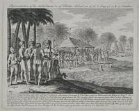
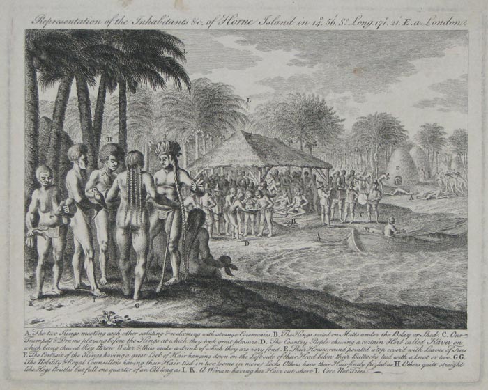
Representation of the Inhabitiants &c. of Horne Island in 14º 56'. S.º Long 171º 21'. E. a London.
[n.d., c.1780.]
Engraving. 185 x 235mm, 7½ x 9¼".
In 1616 the Dutch explorers Schouten and LeMaire stumbled across the Hoorn Islands, Futuna and Alofi, in the Pacific. The rulers of each island joined together for a feast in honour of the guests, as shown here, including a kava ceremony. This was the first time Europeans had witnessed such an occasion.
[Ref: 11069] £260.00
(£312.00 incl.VAT)
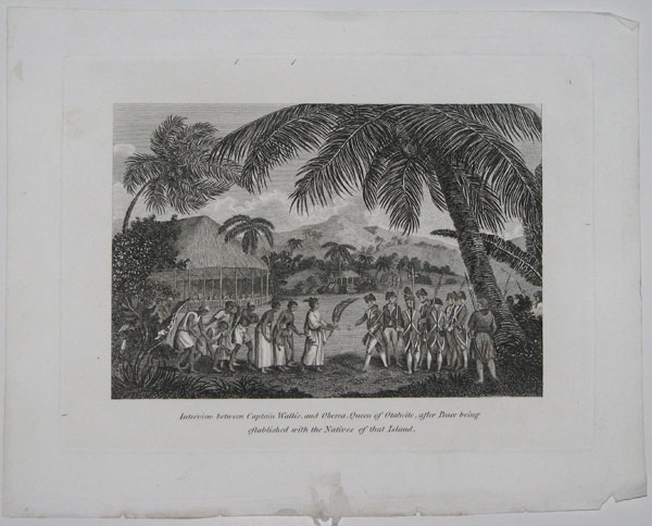
Interview between Captain Wallis, and Oberea, Queen of Otaheite, after Peace being established with Native of that Island.
[n.d. c.1800.]
Copper engraving. Plate 165 x 222mm. 6½ x 8¾". Small nicks and tears along lower edge.
Captain Samuel Wallis (1728-1795) commanded HMS Dolphin on a voyage to circumnavigate the world. Along the Strait of Magellan, Wallis veered towards Tahiti where he was received by Queen Oberea c.1772. In the National Library of Australia.
[Ref: 20761] £110.00
(£132.00 incl.VAT)
![Vüe des Deux Isles des Larrons. [&] Vüe de la Coste du Nord Ouest de Saypan.](img-thumbnail/jpegs/18881.jpg)
Vüe des Deux Isles des Larrons. [&] Vüe de la Coste du Nord Ouest de Saypan. Suppl. au Tome X. No.20.
[Baussard fecit.]
[Didot. 1756.]
Engraving. 216 x 367mm. 8½ x 14½". Creasing down left-hand side; two vertical folds.
A view of the Ladrones Islands, east of the Philippine Sea and the North East coastline of the northern Island. From "Histoire générale des voyages, ou nouvelle collection de toutes les relations de voyages par mer et par terre".
[Ref: 18881] £130.00
(£156.00 incl.VAT)
![[Woman from Rogeia Island, Papua New Guinea]](img-thumbnail/jpegs/41162.jpg)
[Woman from Rogeia Island, Papua New Guinea] Papua-Frau von Rogia (Heath-Insel) China-Strasse, Neu-Guinea.
Verlag von A. Asher & Co. in Berlin Lith. Anst. von C.L. Keller in Berlin S [c.1887]
Lithograph with hand-colouring, printed area 325 x 210mm (12¾ x 8¼"). Rare.
Plate from 'Tätowiren, Narbenzeichnen und Körperbemalen; ein Beitrag zur vergleichenden Ethnologie' ('Tattoing, scarring and body painting: a contribution to comparative ethnology') by the German ethnographer Wilhelm Joest (1852-97). His collections are preserved in the Rautenstrauch-Joest Museum in Cologne, Germany.
[Ref: 41162] £130.00
(£156.00 incl.VAT)
![[Native of Banaba Island]](img-thumbnail/jpegs/41163.jpg)
[Native of Banaba Island] Eingeborener von Banaba (Gilbert-Inseln)
Verlag von A. Asher & Co. in Berlin Lith. Anst. von C.L. Keller in Berlin S [c.1887]
Lithograph with hand-colouring, printed area 325 x 210mm (12¾ x 8¼"). Rare.
Man from Banaba Island in the Pacific Ocean, part of the Gilbert Islands (which became independent as the Republic of Kiribati in 1979). Plate from 'Tätowiren, Narbenzeichnen und Körperbemalen; ein Beitrag zur vergleichenden Ethnologie' ('Tattoing, scarring and body painting: a contribution to comparative ethnology') by the German ethnographer Wilhelm Joest (1852-97). His collections are preserved in the Rautenstrauch-Joest Museum in Cologne, Germany.
[Ref: 41163] £130.00
(£156.00 incl.VAT)
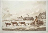
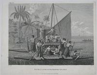
The Narta, or Sledge for Burdens in Kamtschatka. [NB not mentioned in Cooks last Voyage.]
J. Webber fecit.
[London Pub.d July 1, 1789 by J. Webber No. 312 Oxford Street.]
Coloured soft ground etching, printed in sepia and hand finished. Sheet 300 x 450mm (11¾ x 17¼") on paper watermarked 'J Whatman, undated. Trimmed within plate, losing publication line at bottom, close to image at top; unprinted area in bottom left corner patched. Repairs.
A scene with a man on skis beside a dog sledge, huts and a smoking volcano in the background. It was one of twelve plates in his 'Views in the South Seas', drawn, etched and originally published separately 1788-92 by John Webber, draughtsman on Cook's Third Voyage. Boydell reissued the Views (with four new plates) with plates dated 1809, but Abbey's example has Whatman watermarks dated 1820. We have traced an example of this plate with the Webber publication line also watermarked 'J Whatman', undated. Abbey 595 for Boydell edition. See Ref: 31816
[Ref: 59114] £650.00
Kerguelen's Land called by C. Cook Island of Desolation. N. B. the shaded coast is from the English, the unshaded from the French observation in Feby 1772. aaa Track of the Resolution & Discovery in Dec.r 1776. [Inset:] Islands discovered by M. Marion du Fresne 1772 called by C. Cook in 1776 Prince Edward Isles. 2.
Writing by Harmar.
[n.d. c.1784.]
Engraving. Plate 266 x 310mm. 10½ x 12¼". Two folds, creasing and small tear in plate upper right.
The Kerguelen Islands, also known as the Desolation Islands, in the Indian Ocean. Captain James Cook visited the Islands in 1776 during his last voyage. Plate 2 from 'Volume 4 of Cook, James, 1728-1779. A Voyage to the Pacific Ocean: undertaken, by the command of His Majesty, for making discoveries in the northern hemisphere'. National Library of Australia.
[Ref: 20880] £130.00
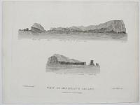
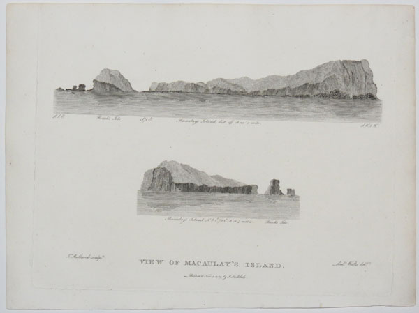
View of Macaulay's Islands.
Lieu.t Watts del. T. Medland sculp.t.
Published Nov. 5. 1789 by J. Stockdale.
Engraving. 210 x 255mm (8½ x 10"). Trimmed within plate at top. Small margins on 3 sides.
Skeches of a rocky island in the Kermadec Islands, named by the artist, Lieutenant John Watts, after one of the crew of the 'Lady Penryn', the first Europeans to visit the area. From Phillip's 'The voyage of Governor Phillip to Botany Bay', published in London in 1789, although illustrating Watts's account of the return voyage via Canton, also described in the book. Watts (17551801) had been a midshipman in Resolution on James Cook's third voyage to the Pacific, 1776-80, but had travelled to Australia with the First Fleet as a passenger. On the return leg he was the supercargo (i.e.. in charge of the cargo).
[Ref: 44039] £120.00
(£144.00 incl.VAT)
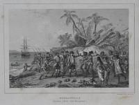
Départ Pour Une Excursion dans L'Ile d'Ualan. (Iles Carolines). Pl.22.
Dessiné d'après nab: par Kittlitz. Bichebois lith.é fig. par Wattier.
Lith. de Thierry frères, successeurs de Engelmann & Cie. 1.re Edition. [n.d. c.1835.]
Lithograph. 273 x 361mm. 10¾ x 14¼".
White explorers greeted by natives on Kosrae, the most eastern of the Caroline Islands. From "Voyage autour du monde, execute par ordre de Sa Majeste l'empereur Nicolas 1er, sur la corvette le Seniavine". In the National Library of Australia.
[Ref: 24639] £120.00
(£144.00 incl.VAT)
![[La Perouse.] On Jette à la Mer un Indien qui avait Frappé un Matelot à Coups de Maillet.](img-thumbnail/jpegs/62175.jpg)
[La Perouse.] On Jette à la Mer un Indien qui avait Frappé un Matelot à Coups de Maillet.
[Paris: Librairie de l'Encyclopédie du XIXe siècle, 1849.]
Etching. Sheet 135 x 200mm (5¼ x 8").
A South Sea Islander being thrown into the sea from a longboat, having hit a French sailor with a mallet. From 'Voyages autour du monde', collected by William Smith.
[Ref: 62175] £65.00
(£78.00 incl.VAT)


![Inauguration du Monument [elevé par l'Astrolabe à lapérouse à Vanikoro.]](jpegs/8178.jpg)


![[Fiji] Vah-Ta-Ah. The Feejeean Princess.](jpegs/46767.jpg)

![[Oceania] Flicka Pa Tahiti.](jpegs/11397.jpg)


![[Five oval portraits from Cook's Voyages].](jpegs/7118.jpg)
![[Oceania] Hoaori](jpegs/11398.jpg)
![[Oceania] Hofding Pa Lefuka.](jpegs/11396.jpg)

![[Hoorn Islands?]](jpegs/53717.jpg)
![Vüe des Deux Isles des Larrons. [&] Vüe de la Coste du Nord Ouest de Saypan.](jpegs/18881.jpg)
![[Woman from Rogeia Island, Papua New Guinea]](jpegs/41162.jpg)
![[Native of Banaba Island]](jpegs/41163.jpg)


![[La Perouse.] On Jette à la Mer un Indien qui avait Frappé un Matelot à Coups de Maillet.](jpegs/62175.jpg)