Results 1-8 of 8
<<< Previous 1 Next >>>
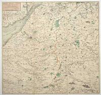
Map of 24 Miles Round the City of Bath, Most humbly dedicated to the Residents and Visitors by their obedient Servant C. Harcourt Masters.
[n.d., c.1812.]
Engraved map with original hand colour. Dissected and laid on linen, as issued, total 590 x 615mm (23¼ x 24¼"), folded into slipcase with old ink mss. title.
A detailed map of the environs of Bath, marking Glastonbury clockwise to Bristol, Newport, Cirencester, Cricklade and Salisbury. Library of Congress, Bath in Time.
[Ref: 59723] £360.00
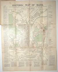
Historic Map of Bath. Indicating the Sites of Public Buildings and Residences of Famous Personages Connected with the History of the City.
Prepared by T. Sturgis Cotterell.
Printed and Published at the Bath Chronicle & Bath Pictorial Offices. Revised to 1898.
Wood engraved map, printed in colours. 570 x 450mm (22½ x 17¾"), folded into original printed boards, adverts on verso. Map with wax stains; covers taped at spine, damped stained.
A tourist's map of Bath, with extensive keys of important sights. Among the list of famous residents are the Henry Fielding, William Herschel, Beau Nash, Frederick Leighton, Thomas Gainsborough and, of course, Jane Austen.
[Ref: 59725] £75.00
![[Untitled map of Bath]](img-thumbnail/jpegs/59729.jpg)
[Untitled map of Bath]
London: G.W. Bacon & Co., Ltd., Norwich St. E.C.4.
[n.d., c.1920.]
Wood-engraved map. Sheet 670 x 830mm (26½ x 32¾"), folded into original cloth covers. Splits in folds, tape stains.
A map of Bath with advertisments for the wine merchants 'Sainsbury Bros.', famous tea and coffee merchants 'Gillards of Bath' and milliners William Rayner. We have dated the map from Bacon's address, which they used 1919-22.
[Ref: 59729] £60.00
![Cary's Traveller's Companion, or, A Delineation of the Turnpike Roads of England & Wales [...]](img-thumbnail/jpegs/59721.jpg)
Cary's Traveller's Companion, or, A Delineation of the Turnpike Roads of England & Wales [...] [with] Cary's New Itinerary: or, An Accurate Delineation of the Great Roads, Both Direct and Cross, Throughout England and Wales; With many of the principal Roads in Scotland.... Second Edition with Improvements.
London. Printed for John Cary, Engraver, Map & Printseller, Strand. 1st Jan.y 1791. [&] London: Printed for John Cary, No. 181 Strand, 1802 [-3].
Two works in one; 8vo (180 x 120mm, 7 x 4¾"), original full diced calf travelling case with empty pockets front and back. 'Companion': engr. title, pp. (iv)+(6)+(2)(ads); index map, 42 maps printed back to back, 1 folding map. 'Itinerary': engr. title & dedication; pp. (iv)+(1)(ad)+868+(2)(ads). All maps with original hand colour. With the bookplate of Henry Pakenham-Mahon of Strokeston Park. Binding with tear to flap, some wear and fading. Folding map of Yorkshire with tear on fold; two folding maps of 'Itinerary' both trimmed to allow opening of segments, one segment loose, with tears on folds.
An unusual travelling edition of two works by John Cary. The 'Traveller's Companion' has a map of England and Wales, 41 counties and maps of North & South Wales. The 'Itinerary' has two road maps of England & Wales, with extensive indexes of the roads. The adverts list some of Cary's maps, with one page dedicated to his globes. The empty pockets in the covers would most likely contain larger folding maps not called for in either the 'Companion' or 'Itinerary'. Henry Pakenham-Mahon (1851-1922) was an amateur photographer: in 2012, a collection of 324 of his glass plates was uncovered at Strokestown Park including several explicit images of live models. Strokestown (in County Roscommon, Ireland) is now home to the National Irish Famine Museum. Henry's grandfather was Denis Mahon, whose responce to a rent strike by his tenants at Strokestown was to evict them and force them to sail to Quebec in 1847, filling four ships. When news came back to Ireland that nearly half the passengers had died on route (primarily from cholera) Mahon was ambushed and shot dead, to general celebration.
[Ref: 59721] £850.00
view all images for this item
![Geological Survey of England and Wales. Index Map Sheet 11 [Somerset, Wiltshire, Gloucestershire, Oxfordshire and Monmouthshire, etc].](img-thumbnail/jpegs/59730.jpg)
Geological Survey of England and Wales. Index Map Sheet 11 [Somerset, Wiltshire, Gloucestershire, Oxfordshire and Monmouthshire, etc].
Wyman & Sons Ltd. Lith, 63, Carter Lane, 8575.7.96.
Engraved and Published at the Ordnance Survey Office, Southampton, in 1891[-6].
Chromolithographic map. Dissected and laid on linen, as issued, sheet 670 x 905mm (26½ x 35½"), folded into buckram covers with 'G Philip & Son' label with mss. title. Splits in linen.
A colourful geological map, covering from Taunton in the south west, clockwise to Merthyr Tydfil, Hereford, Buckingham, Oxford, Reading, Winchester and Sherbourne. This index sheet covered twelve sheets of the 1 inch series of geological maps.
[Ref: 59730] £260.00
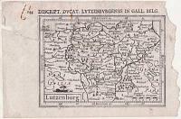
Lutzenburg.
[engraved by Jodocus Hondius II.]
[Amsterdam, c.1616.]
Engraved map. 95 x 135mm (3¾ x 5¼"), with letterpress sur-title. Repaired tear, right margin ragged, rust stains, laid on album paper.
A miniature map of Luxembourg, engraved by Jodocus Hondius II for the the 'Tabularum Geographicarum' atlas, with a text by Petrus Bertius. The is the second plate used by Bertius, replacing one engraved by Pieter van den Keere. It is recognisable by having wider borders and longitude & latitude scales.
[Ref: 59896] £130.00
![[Scrap sheet relating to Peerless Pool, including 2 complete adverts.]](img-thumbnail/jpegs/59824.jpg)
[Scrap sheet relating to Peerless Pool, including 2 complete adverts.]
[Various dates, 1746-c.1820]
Eight scraps on one sheet: a pencil sketch, map, etching, two wood engravings & three letterpress extracts. Sheet 680 x 490mm (27 x 19¼"). Scarce. Map trimmed with colour added in places.
In 1743 William Kemp bought a spring-fed pond called Perilous Pond on Old Street, London, and created a pair of stone-edged pools, one for swimming in summer and skating in winter and one for fishing. Originally named for the number of drownings that occured there, he renamed it Peerless Pool and created a very successful business. The map is a section of one sheet of the monumental 24-sheet map of London by John Rocque, 1746.
[Ref: 59824] £360.00

An Improved Map of the County of Somerset Divided into it's Hundreds: Laid down & Collected from the best materials, and illustrated with various additional Improvements; with Historical Extracts relative to its Natural Produce, Trade, Manufactures &c.
By Eman: Bowen, Geographer to His Majesty.
Printed for Carington Bowles in St Pauls Church Yard. Rob.t Sayer in Fleet Street [n.d., c.1767].
Engraved map with original colour. Dissected and laid on linen, probably as issued, total 540 x 720mm (21¼ x 28¼"), with index label on linen. Three old ink stamps from a French library and crayon mss. on map area.
A map of Somerset, surrounded by engraved text and decorated with decorative cartouches for the title & scale and a plan of Bath. It was engraved by Emmanuel Bowen for John Hinton's 'Large English Atlas', the first new large-format county maps in a century. The maps were issued individually, starting in 1749 and completed in 1760, when the full atlas was published. The maps were still available individually, as this example, which is presented as a travel map.
[Ref: 59724] £350.00
<<< Previous 1 Next >>>


![[Untitled map of Bath]](jpegs/59729.jpg)
![Cary's Traveller's Companion, or, A Delineation of the Turnpike Roads of England & Wales [...]](jpegs/59721.jpg)
![Geological Survey of England and Wales. Index Map Sheet 11 [Somerset, Wiltshire, Gloucestershire, Oxfordshire and Monmouthshire, etc].](jpegs/59730.jpg)

![[Scrap sheet relating to Peerless Pool, including 2 complete adverts.]](jpegs/59824.jpg)
