Results 1-3 of 3
<<< Previous 1 Next >>>
![Map of the Island of Capri, in the Gulf of Naples. [Numbered key to top left for 12 points of interest.] Plate 20, Vol. 4.](img-thumbnail/jpegs/55500.jpg)
Map of the Island of Capri, in the Gulf of Naples. [Numbered key to top left for 12 points of interest.] Plate 20, Vol. 4.
E. Gullan, sculp.
No.22, of R.Ackermann's Repository of Arts, &c. Pub. Octr. 1, 1810, at 101, Strand, London.
Engraving with added hand colour. 146 x 234mm. 5¾ x 9¼". Toning and tears around the edges.
A map of the Italian island, Capri, in the Tyrrhenian Sea off the Sorrentine Peninsula. Ackermann's Repository of Arts was an illustrated, British periodical published from 1809-1829 by Rudolph Ackermann. The formal title of the publication was "Respository of Arts, Literature, Commerce, Manufactures, Fashions, and Politics", and it did cover all of these fields. At the time, it was considered to be of great influence to the English taste in fashion, architecture, and literature.
[Ref: 55500] £95.00
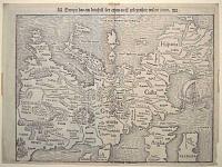
Europa das ein drittheil der erden / nach gelegenheit unsern zeiten.
[Basle, Heinrich Petri, c.1550.]
Woodcut. Sheet 282 x 375mm (11 x 14¾"). Margin bottom left restored, tape stains in edges. Evidence of cracks in the woodblock.
Munster's famous upside-down map of Europe, although omitting most of Scandinavia, Scotland and half of Ireland. Despite the strange orientation (a German convention to align maps with the solar compass) it is the first map of the continent not based on Ptolemy. The map was first used in Munster's edition of Ptolemy's 'Geographia' in 1540 and also appeared in his 'Cosmographia'; the cracks in the woodblock first appeared in 1545. A new, similar block was used from 1571-2 until 1578, when a new map, copied from Ortelius, was introduced.
[Ref: 55504] £990.00
view all images for this item

Xuntien alias Quinzay.
[Frankfurt: Matthias Merian, c.1655.]
Engraving. 180 x 255mm (7 x 10"), with very large margins.
An early map of the Chinese city of Quinzay (Hangchow), based on Marco Polo's account of China in the late 12th Century, when it was the capital of the Sung Dynasty. Polo's usual exaggerated account tells of 12,000 bridges, a massive network of canals the large 'Western Lake' 30 miles in diameter with island pavilions and palaces.
[Ref: 55450] £220.00
<<< Previous 1 Next >>>
![Map of the Island of Capri, in the Gulf of Naples. [Numbered key to top left for 12 points of interest.] Plate 20, Vol. 4.](jpegs/55500.jpg)

