Results 1-13 of 13
<<< Previous 1 Next >>>

Plan and Survey of Ascot Race Course, in the County of Berks; including the Rises and Fall; with Notes Referring to an Appendix; by W.m Kemp. To the Kings Most Excellent Majesty This Plate being No.4. of a Series of Surveys, of the Principal Race Courses in England Is respectfully dedicated by His most obedient Subject & Servant, W.m Kemp [facsimile signature.]
Davies sculp. 34 Compton St. Brunsw.k Sq.e.
London, Published by Sherwood, Jones & Co. Paternoster Row, July, 1824.
Engraved map with hand colour, 210 x 255mm (8¼ x 10"), watermarked 'J Whatman 1823'. Folded as issued. Some light foxing.
A plan of Ascot Race Course with profiles of the elevations of each route.
[Ref: 63728] £120.00

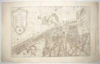
Plan General du Chateau de Bagnolet et de ses Jardins. Appartenant a S.A.R. Madame la Duchesse d'Orleans. du dessein de M.r Desgotz, architecte du Roi et Controlleur de ses Bâtiments. [&] Elevation de la façade de Château de Bagnolet du côté du Jardin. [&] Plan du pavillon appellé l'Hermitage dans le Jardin du Château de Bagnolet.
AParis chez Mariette rue S. Jacques aux Colones d'hercule [n.d., c.1700].
Three plates stitched on left edge: engraved plan & two architectural plates. Each sheet 470 x 605mm (18½ x 23¾").
A finely-engraved plan and plates of Marly, showing the positions of the house, ornamental gardens and parkland, with an extensive key.
[Ref: 63862] £420.00
view all images for this item
Plan General des Chateaux, Parc et Jardins de Chantilly. Situé dans le Isle de France, à neuf lieues de Paris et à une lieue de Senlis. Appartenant à S.A.S. Monseigneur le Prince de Condé.
a Paris chez Jean Mariette rue S. Jacques aux Colonnes d'Hercules [n.d., c.1700].
Engraved plan, 18th century watermark. Two sheets conjoined, total 440 x 705mm (17¼ x 27¾"), very large margins. Sheets not joined quite straight, some creasing. Uncut.
A finely-engraved plan of Chantilly, showing the positions of the house, ornamental gardens and parkland, with an extensive key.
[Ref: 63858] £480.00

Plan and Survey of Doncaster Race Course; in the West Riding of Yorkshire; including the Rises and Fall; with Notes Referring to an Appendix; by W.m Kemp. To The Mayor and Corporation of The Town of Doncaster; This Plate, being No.5, of a Series of Surveys, of the Principal Race Courses in England; is most Respectfully Dedicated by Their most obed.t and very humble Servant, W.m Kemp [facsimile signature.]
Davies sculp. 34 Compton St. Brunsw.k Sq.
London, Published by Sherwood, Jones & Co. Paternoster Row. [n.d., 1824.]
Engraved map with hand colour, J. Whatman 1824 watermark; 215 x 280mm (8½ x 11"). Trimmed within plate, two vertical binding folds, as normal..
Doncaster Racecourse, South Yorkshire. It is one of the oldest establised centres for horse racing in Great Britain, with records of regular racing meetings going back to the 16th Century.
[Ref: 63729] £95.00

Plan and Survey of Egham Race Course; in the County of Surrey; with Notes Referring to an Appendix; by Wm. Kemp. To His Royal Highness The Duke of York; This Plate, being No.6 of a Series of Surveys, of the Principal Race Courses in England; is most Respectfully Dedicated, by His most obedient, and very humble Servant, [facsimile signature:] Wm. Kemp.
Davies sc. 34 Compton St. Brunsw.k Sq.re.
London, Published by Sherwood, Jones & Co. Paternoster Row. [n.d. c.1825.]
Engraved map with hand colour, 210 x 275mm (8¼ x 10½). Two vertical folds as published
Egham Racecourse was situated in Runnymede Meadows from 1734-1884 before the racing was moved to Kempton Park, due to large gangs of London pickpockets invading the Egham meetings.
[Ref: 63730] £80.00

Plan of Hyde Park taken on the fourth of June 1800 Representing the Position of those Volunteer & Associated Corps who assembled to testify their Affectionate Attachment to his Majesty and to commemorate the Day which gave Birth to The Best of Sovereigns.
London Pub.d June 18.th 1800 by Random & Stainbank 17 Old Bond Str.
Scarce coloured map. Sheet 270 x 340mm (10½ x 13¾"). Trimmed within plate, central fold, mounted in album paper at edges.
A plan of Hyde Park, showing the placings of the the Volunteer Regiments during a military review celebrating George III's birthday in 1800.
[Ref: 63567] £390.00

A Plan of the Review of the Volunteers of Middlesex; on the 4.th of June 1799 in Hyde Park, shewing the station of every company, their na,es & number of Men in each.
[Cooke sc. Howland.]
[Publish'd June 25th 1799 by Wm Walker 31 Old Bond Street.]
Scarce coloured map. Sheet 310 x 430mm (12¼ x 17"). Trimmed within plate, affecting title and insciptions; central fold, mounted in album paper at edges.
A plan of Hyde Park, showing the placings of the the Volunteer Regiments during a military review celebrating George III's birthday in 1799.
[Ref: 63568] £480.00

A New Pocket Plan of the Cities of London & Westminster with the Borough of Southwark Comprehending the New Buildings and other Alterations to the Year 1798.
[London: William Faden, 1798.]
Scarce engraved map with old hand colour. 295 x 515mm (11¾ x 20½") very large margins. Centre fold as issued and crease.
A detailed map of London extending to Knightsbridge in the west, clockwise to Paddington, Islington, Bethnall Green, Mile End, Sun Tavern Fields, Lambeth and Tothill Fields.
[Ref: 63566] £380.00

Plan General du Chateau, Jardin, Parc, et Dependances de Marly.
T.F.E. Monnot.
a Paris chez Mariette rue S. Jacques aux Colones d'hercule [n.d., c.1700].
Engraved plan, 18th century watermark. 420 x 435mm (16½ x 17¼"), with large margins. Creasing. Central crease as normal.
A finely-engraved plan of Marly, showing the positions of the house, ornamental gardens and parkland, with an extensive key.
[Ref: 63860] £360.00

Plan General des Jardins et Parc du Château de Meudon appartenant au Roy, scis à deux lieues de Paris sur le sommet d'un côteau qui borde la riviere de Seine.
AParis chez Mariette rue S. Jacques aux Colonnes d'Hercules [n.d., c.1700].
Engraved plan, 18th century watermark. 420 x 540mm (16½ x 21¼"), with large margins. Uncut. Central crease as normal.
A finely-engraved plan of Meudon, showing the positions of the house, ornamental gardens and parkland, with an extensive key.
[Ref: 63859] £360.00

Plan and Survey of Stamford Race Course; in Lincolnshire; including the Rises and Falls; with Notes Referring to an Appendix; by W.m Kemp. To The R.t Hon.ble The Marquis of Exeter: This Plate, being No.7, of a Series of Surveys, of The Principal Race Courses in England; is most Respectfully Dedicated; by his most obed.t and very humble Servant, Wm. Kemp [facsimile signature.]
Davies sc. 34 Compton St. Brunsw.k Squ.
London, Published by Sherwood, Jones & Co. Paternoster Row. [n.d., 1824.]
Engraved map with hand colour, 215 x 265mm (8½ x 10½"). Vertical binding folds as issued. Age spots.
A plan and survey of Stamford Race Course.
[Ref: 63731] £85.00
![[The Devil's Tower, Yelabuga, Tatarstan, titled in Cyrillic.]](img-thumbnail/jpegs/63695.jpg)
[The Devil's Tower, Yelabuga, Tatarstan, titled in Cyrillic.]
[Ivan Ivanovich Shishkin.]
[1855.]
Lithograph. Sheet 300 x 220mm (11¾ x 8¾"). Long split taped, trimmed close at top, creasing and folds.
A sketch of a 12th century watchtower, a rare surviving building of the mediæval state of Volga Bulgaria, which was ended by the Mongol invasion in the 13th century. It shows the tower before extensive restoration by a local merchant in 1867, which including re-roofing it and preventing entry. The merchant's son was Ivan Ivanovich Shishkin (1832-98), a famous painter who drew this sketch. Underneath is a sketch map of the area.
[Ref: 63695] £70.00
(£84.00 incl.VAT)

Plan General de la Ville Chateau Jardins et Parc de Versailles nouvellement levé sur les lieux.
AParis chez Jombert rue Dauphine [n.d., c.1740].
Engraved plan. 420 x 435mm (16½ x 17¼"). Damage at top with loss of printed area. Creases as normal.
A finely-engraved plan of Versailles, showing the positions of the house, ornamental gardens and parkland, with an extensive key.
[Ref: 63861] £220.00
<<< Previous 1 Next >>>


![[The Devil's Tower, Yelabuga, Tatarstan, titled in Cyrillic.]](jpegs/63695.jpg)
