Results 1-50 of 50
<<< Previous 1 Next >>>
![[3 September 1843 Revolution]](img-thumbnail/jpegs/61674.jpg)
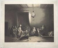
[3 September 1843 Revolution] Aohnai. Le Septembre 1843.
[n.d. c.1844.]
Scarce lithograph, sheet 280 x 345mm (11 x 13½"). Repaired crease.
A view of the 3rd September 1843 Revolution; an uprising by the Hellenic Army in Athens, supported by large sections of the people, against the autocratic rule of King Otto. An army stands outside the Old Royal Palace.
[Ref: 61674] £280.00
(£336.00 incl.VAT)
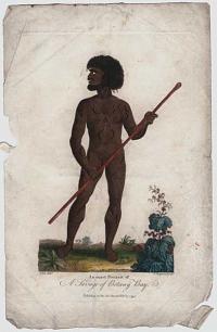
An exact Portrait of A Savage of Botany Bay.
J. Ihle Del.t. J. Chapman Sculp.t.
Published as the Act directs, Feb.y 1 1795.
Coloured engraving. 185 x 120mm (7¼ x 4¾"). Creasing and surface soiling. Small margins.
Drawn by Johann Ihle for Ebenezer Sibly's five-volume ''Universal System of Natural History'', 1794-6.
[Ref: 61454] £130.00
(£156.00 incl.VAT)
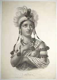
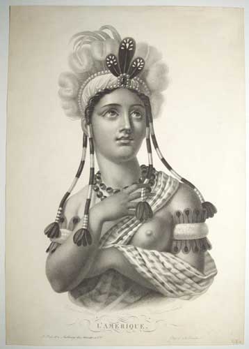
L'Amerique.
Dessine par Vauthier. Terminé par Bertrand.
A Paris et a Ausbourg chez Tessari et C.ie. Depose a la Direction. [n.d. c.1820]
Stipple, sheet 390 x 275mm (15½ x 10¾"). Trimmed to plate left and right. Small margin at bottom.
An early form of the allegorical figure representing "America". A head-and-shoulders portrait of a young Native American woman. She wears a fabric robe with left breast exposed, a feathered headdress with beaded braids, and feathered armbands.
[Ref: 61497] £230.00
(£276.00 incl.VAT)
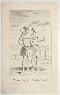
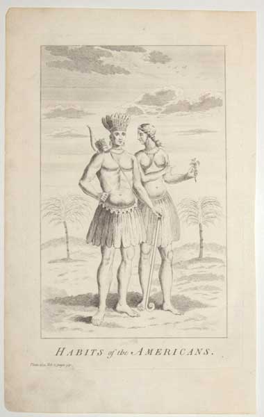
Habits of the Americans. Plate 224. Vol. 2, page 541.
[London: Richard Baldwin, 1759.]
Engraving, 18th century watermark. 315 x 205mm (12¼ x 8") very large margins.
Two Native Americans, based on John White's Virginians.
[Ref: 61377] £180.00
(£216.00 incl.VAT)

[Defence of the Arrah House. Against three Mutinous Regiments and a large body of Insurgents. Under Koer Singh - Dedicated to K. V. Boyle, Esquire, C. E. To whose skill and forethought the safety of the Garisson is principally to be attributed by, W. Tayler. B. C. S.]
Maclure & Co Chromo - lith London.
[n.d., c.1857].
Scarce chromolithograph. Framed, sight size 325 x 490mm (12¾ x 19¼"). Unexamined out of frame.
A depiction of the defence of the Arrah House against Koer Singh during the Indian Mutiny of 1857. Soldiers can be seen storming the regency gardens, some firing from behind plants and trees, whilst others lay dead, with their weapons, on the ground; two cannons are fired in the centre of the image as a building, to the left, burns. The artist, William Tayler (1808-1892), was Commissioner of the Province of Patna
[Ref: 61572] £790.00
Unfortunately this item is either sold or reserved. If you are interested in similar items and cannot find what you're looking for on our website, please consider filling in our interests form. If you register, we can also send you items that match your interests when the website is updated.

Frontispiece de l'Asie.
[n.d., c.1805.]
Coloured etching. 155 x 115mm (6¼ x 4½"), very large margins.
A woman in a turban with ostrich feathers seated by an incense burner.
[Ref: 61472] £130.00
(£156.00 incl.VAT)
![[Asian Heads]](img-thumbnail/jpegs/61461.jpg)
[Asian Heads]
[n.d. c.1850]
Stipple 150 x 200mm (6 x 8"). Trimmed within plate. Left corner missing.
A sort of ethnographic print depicting Asian people; many featuring wonderful facial hair.
[Ref: 61461] £70.00
(£84.00 incl.VAT)
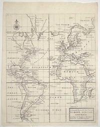
A General Chart of the Sea Coast of Europe, Africa & America. According to E. Wrights or Mercator's Projection.
By H. Moll Geographer.
[n.d., 1720.]
Engraved map. 345 x 285mm (13½ x 11¼"). Original binding folds.
A sea chart centred on the Atlantic Ocean, but also showing all of South America, Africa and the Black Sea. Of interest in the mythical Peypys Island off South America. From Josiah Burchett's 'A Complete History of the Most Remarkable Transactions at Sea, from the Earliest Account... to the Conclusion of the Last War with France''. Edward Wright (1561-1615), a mathmatician and surveyor, not only corrected Mercator's Projection but also published a guide explaining how to use charts using that projection, something that Gerhard Mercator had never done. His work gave British navigators a particular advantage over the competition.
[Ref: 61702] £250.00
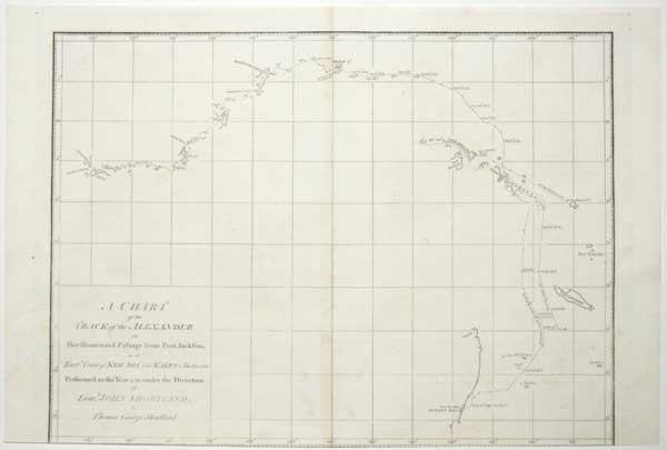
A Chart of the Track of the Alexander on Her Homeward Passage from Port Jackson on the East.n Coast of New South Wales to Batavia; Performed in the Year 1788 under the Direction of Lieut.t John Shortland.
by Thomas George.
[Publish'd as the Act directs by J. Stockdale August 24th 1789.]
Engraved map. 275 x 380mm (10¾ x 15"). Trimmed into printed border at bottom, losing publication line; holes in image filled.
A chart of the return route of the 'Alexander', one of the ships of the First Fleet. It was published in Arthur Phillips 'A Voyage to Botany Bay
'
[Ref: 61705] £220.00
![[Blenheim] Plan der Roemrugtige Veltslag can Hochstet door de Geallieerde Gewonne op den 13 Augusti 1704.](img-thumbnail/jpegs/61398.jpg)
[Blenheim] Plan der Roemrugtige Veltslag can Hochstet door de Geallieerde Gewonne op den 13 Augusti 1704. Plan de la Glorieuse Bataille dHochstet Gagnée Par Les Alliez le 13 Aout 1704.
J. v. Vianen fecit.
[The Hague: Jean Rousset de Missy, 1729.]
Engraved map. 480 x 435mm (19 x 17") very large margins. A few tears in margins, some taped, some spotting.
A plan of the Battle of Blemheim (or Höchstädt, 13th August 1704), in which the Army of the Grand Alliance, led by the Duke of Marlborough and Prince Eugene of Savoy, decisively beat a Franco-Bavarian army that was on route to attack Vienna. From ''Histoire militaire du prince Eugène de Savoie, du prince et duc de Marlborough, et du prince de Nassau-Frise, où l'on trouve un détail des principales actions de la dernière guerre et des batailles et sièges commandez par ces trois généraux''.
[Ref: 61398] £380.00
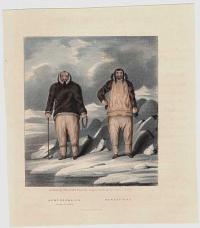
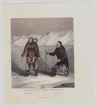
![[Bothians] Ikmalick And Apeagliu.](img-thumbnail/jpegs/61719.jpg)
[Bothians] Ikmalick And Apeagliu.
On Stone by J. Brandard, from the original Drawing by Captain Ross. Printed by Graf & Soret.
[London: A. W. Webster, 156 Regent Street, 1835.]
Lithograph with hand colour. Sheet 185 x 235mm (7¼ x 9¼")
Two native Canadians and three Englishmen sit in a room, presumambly on a boat. An illustration from the separately-issued appendix to 'Narrative of a Second Voyage in Search of a North-west Passage' by John Ross (1835). Ross was forced by ice to stop at the Boothia peninsula (which he named after his patron Sir Felix Booth) for four years while searching for the North-West Passage. See Abbey Travel 536 for the 'Narrative', with appendix mentioned but not listed.
[Ref: 61719] £180.00
(£216.00 incl.VAT)
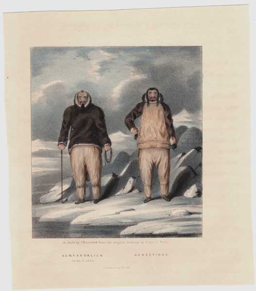
Konyaroklick, or Bald Head. Neweetioke.
On Stone by J. Brandard, from the original Drawing by Captain Ross. Printed by Graf & Soret.
[London: A. W. Webster, 156 Regent Street, 1835.]
Coloured lithograph. Sheet 170 x 150mm (6¾ x 6") Slight offset from text.
Two men from the Boothia Peninsula, Nunavut, Canada. An illustration from the separately-issued appendix to 'Narrative of a Second Voyage in Search of a North-west Passage' by John Ross (1835). Ross was forced by ice to stop at the Boothia peninsula (which he named after his patron Sir Felix Booth) for four years while searching for the North-West Passage. See Abbey Travel 536 for the 'Narrative', with appendix mentioned but not listed.
[Ref: 61410] £95.00
(£114.00 incl.VAT)
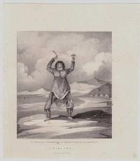
Hibluna.
On Stone by J. Brandard, from the original Drawing by Captain Ross. Printed by Graf & Soret.
[London: A. W. Webster, 156 Regent Street, 1835.]
Lithograph. Sheet 170 x 150mm (6¾ x 6") Trimmed, faint spotting.
A woman from the Boothia Peninsula, Nunavut, Canada, holding up tools. An illustration from the separately-issued appendix to 'Narrative of a Second Voyage in Search of a North-west Passage' by John Ross (1835). Ross was forced by ice to stop at the Boothia peninsula (which he named after his patron Sir Felix Booth) for four years while searching for the North-West Passage. See Abbey Travel 536 for the 'Narrative', with appendix mentioned but not listed.
[Ref: 61409] £80.00
(£96.00 incl.VAT)
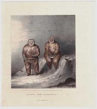
Alictu and Kanguagiu.
On Stone by J. Brandard, from the original Drawing by Captain Ross. Printed by Graf & Soret.
[London: A. W. Webster, 156 Regent Street, 1835.]
Coloured lithograph. Sheet 170 x 150mm (6¾ x 6")
Two men from the Boothia Peninsula, Nunavut, Canada, standing before an igloo. An illustration from the separately-issued appendix to 'Narrative of a Second Voyage in Search of a North-west Passage' by John Ross (1835). Ross was forced by ice to stop at the Boothia peninsula (which he named after his patron Sir Felix Booth) for four years while searching for the North-West Passage. See Abbey Travel 536 for the 'Narrative', with appendix mentioned but not listed.
[Ref: 61412] £130.00
(£156.00 incl.VAT)
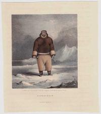
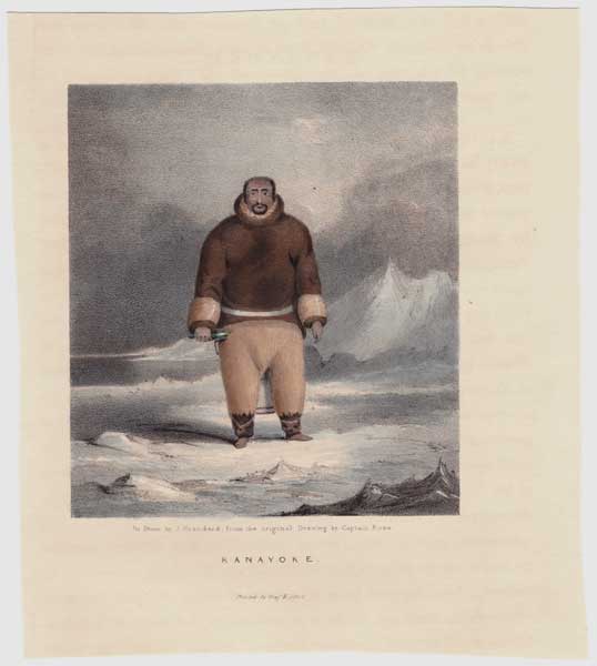
Kanayoke.
On Stone by J. Brandard, from the original Drawing by Captain Ross. Printed by Graf & Soret.
[London: A. W. Webster, 156 Regent Street, 1835.]
Coloured lithograph. Sheet 170 x 150mm (6¾ x 6")
A man of the Boothia Peninsula, Nunavut, Canada, standing in an icy landscape. An illustration from the separately-issued appendix to 'Narrative of a Second Voyage in Search of a North-west Passage' by John Ross (1835). Ross was forced by ice to stop at the Boothia peninsula (which he named after his patron Sir Felix Booth) for four years while searching for the North-West Passage. See Abbey Travel 536 for the 'Narrative', with appendix mentioned but not listed.
[Ref: 61413] £130.00
(£156.00 incl.VAT)
Manellia. Adelik.
On Stone by J. Brandard, from the original Drawing by Captain Ross. Printed by Graf & Soret.
[London: A. W. Webster, 156 Regent Street, 1835.]
Coloured lithograph. Sheet 170 x 150mm (6¾ x 6") Trimmed, one foxing spot bottom centre in image.
Two women from the Boothia Peninsula, Nunavut, Canada, one carrying a child in a backpack. An illustration from the separately-issued appendix to 'Narrative of a Second Voyage in Search of a North-west Passage' by John Ross (1835). Ross was forced by ice to stop at the Boothia peninsula (which he named after his patron Sir Felix Booth) for four years while searching for the North-West Passage. See Abbey Travel 536 for the 'Narrative', with appendix mentioned but not listed.
[Ref: 61408] £95.00
(£114.00 incl.VAT)
![[Bothians] Udlia. Awitigin. Palurak.](img-thumbnail/jpegs/61713.jpg)
[Bothians] Udlia. Awitigin. Palurak.
On Stone by J. Brandard, from the original Drawing by Captain Ross. Printed by Graf & Soret.
[London: A. W. Webster, 156 Regent Street, 1835.]
Lithograph, with hand colour. Sheet 235 x 185mm (9¼ x 7¼")
Three native Canadians. An illustration from the separately-issued appendix to 'Narrative of a Second Voyage in Search of a North-west Passage' by John Ross (1835). Ross was forced by ice to stop at the Boothia peninsula (which he named after his patron Sir Felix Booth) for four years while searching for the North-West Passage. See Abbey Travel 536 for the 'Narrative', with appendix mentioned but not listed.
[Ref: 61713] £180.00
(£216.00 incl.VAT)
![[Bothians] Poyettak. Kakikagiu. Anknalua.](img-thumbnail/jpegs/61714.jpg)
[Bothians] Poyettak. Kakikagiu. Anknalua.
On Stone by J. Brandard, from the original Drawing by Captain Ross. Printed by Graf & Soret.
[London: A. W. Webster, 156 Regent Street, 1835.]
Lithograph. Sheet 235 x 185mm (9¼ x 7¼")
Three native Canadians. An illustration from the separately-issued appendix to 'Narrative of a Second Voyage in Search of a North-west Passage' by John Ross (1835). Ross was forced by ice to stop at the Boothia peninsula (which he named after his patron Sir Felix Booth) for four years while searching for the North-West Passage. See Abbey Travel 536 for the 'Narrative', with appendix mentioned but not listed.
[Ref: 61714] £130.00
(£156.00 incl.VAT)
![[Bothians] Kunana.](img-thumbnail/jpegs/61715.jpg)
[Bothians] Kunana.
On Stone by J. Brandard, from the original Drawing by Captain Ross. Printed by Graf & Soret.
[London: A. W. Webster, 156 Regent Street, 1835.]
Lithograph with hand colour. Sheet 235 x 185mm (9¼ x 7¼")
A native Canadian holding a knife and the skin of something An illustration from the separately-issued appendix to 'Narrative of a Second Voyage in Search of a North-west Passage' by John Ross (1835). Ross was forced by ice to stop at the Boothia peninsula (which he named after his patron Sir Felix Booth) for four years while searching for the North-West Passage. See Abbey Travel 536 for the 'Narrative', with appendix mentioned but not listed.
[Ref: 61715] £180.00
(£216.00 incl.VAT)

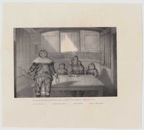
Ooblooria. Paningayuke. mingo. Nullingiak.
On Stone by J. Brandard, from the original Drawing by Captain Ross. Printed by Graf & Soret.
[London: A. W. Webster, 156 Regent Street, 1835.]
Lithograph. Sheet 150 x 170 mm (6 x 6¾")
A family of the Boothia Peninsula, Nunavut, Canada, seated at a table aboard the 'Victory', John Ross's ship. An illustration from the separately-issued appendix to 'Narrative of a Second Voyage in Search of a North-west Passage' by John Ross (1835). Ross was forced by ice to stop at the Boothia peninsula (which he named after his patron Sir Felix Booth) for four years while searching for the North-West Passage. See Abbey Travel 536 for the 'Narrative', with appendix mentioned but not listed.
[Ref: 61415] £130.00
(£156.00 incl.VAT)
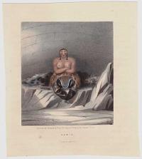
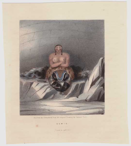
Kemig.
On Stone by J. Brandard, from the original Drawing by Captain Ross. Printed by Graf & Soret.
[London: A. W. Webster, 156 Regent Street, 1835.]
Coloured lithograph. Sheet 170 x 150mm (6¾ x 6")
A woman of the Boothia Peninsula, Nunavut, Canada, seated half-naked in an igloo. An illustration from the separately-issued appendix to 'Narrative of a Second Voyage in Search of a North-west Passage' by John Ross (1835). Ross was forced by ice to stop at the Boothia peninsula (which he named after his patron Sir Felix Booth) for four years while searching for the North-West Passage. See Abbey Travel 536 for the 'Narrative', with appendix mentioned but not listed.
[Ref: 61414] £160.00
(£192.00 incl.VAT)
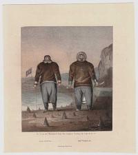
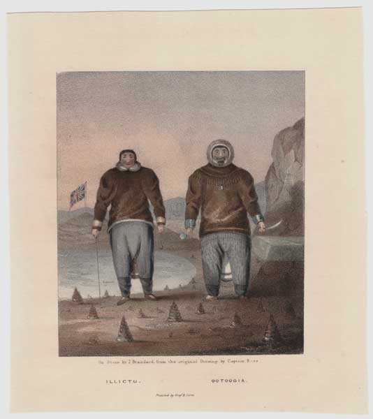
Illictu. Ootoogia.
On Stone by J. Brandard, from the original Drawing by Captain Ross. Printed by Graf & Soret.
[London: A. W. Webster, 156 Regent Street, 1835.]
Coloured lithograph. Sheet 170 x 150mm (6¾ x 6")
Two men from the Boothia Peninsula, Nunavut, Canada, standing on a beach with the Union flag flying behind. An illustration from the separately-issued appendix to 'Narrative of a Second Voyage in Search of a North-west Passage' by John Ross (1835). Ross was forced by ice to stop at the Boothia peninsula (which he named after his patron Sir Felix Booth) for four years while searching for the North-West Passage. See Abbey Travel 536 for the 'Narrative', with appendix mentioned but not listed.
[Ref: 61411] £130.00
(£156.00 incl.VAT)
![[Bothians] Shulanina. Tulluachiu, & Tirikshiu.](img-thumbnail/jpegs/61716.jpg)
[Bothians] Shulanina. Tulluachiu, & Tirikshiu.
On Stone by J. Brandard, from the original Drawing by Captain Ross. Printed by Graf & Soret.
[London: A. W. Webster, 156 Regent Street, 1835.]
Lithograph, with hand colour. Sheet 235 x 185mm (9¼ x 7¼") Names slightly faded.
Three native Canadians, one with a peg leg An illustration from the separately-issued appendix to 'Narrative of a Second Voyage in Search of a North-west Passage' by John Ross (1835). Ross was forced by ice to stop at the Boothia peninsula (which he named after his patron Sir Felix Booth) for four years while searching for the North-West Passage. See Abbey Travel 536 for the 'Narrative', with appendix mentioned but not listed.
[Ref: 61716] £160.00
(£192.00 incl.VAT)
![[Bothians] Kawalua. Tiagashu. Adlurak.](img-thumbnail/jpegs/61718.jpg)
[Bothians] Kawalua. Tiagashu. Adlurak.
On Stone by J. Brandard, from the original Drawing by Captain Ross. Printed by Graf & Soret.
[London: A. W. Webster, 156 Regent Street, 1835.]
Lithograph with hand colour. Sheet 235 x 185mm (9¼ x 7¼")
Three native Canadians. An illustration from the separately-issued appendix to 'Narrative of a Second Voyage in Search of a North-west Passage' by John Ross (1835). Ross was forced by ice to stop at the Boothia peninsula (which he named after his patron Sir Felix Booth) for four years while searching for the North-West Passage. See Abbey Travel 536 for the 'Narrative', with appendix mentioned but not listed.
[Ref: 61718] £160.00
(£192.00 incl.VAT)

Dress of the Inhabitants of California with their manners of Rafts for Fishing, &c.
Published by Alex.r Hogg No. 16 Paternoster Row London [n.d., 1778].
Engraving. 295 x 170mm (11½ x 6¾"), very large margins. Crease top margin.
From 'A New and Complete Collection of Voyages and Travels: Containing All that Have Been Remarkable from the Earliest Period to the Present Time', by John Hamilton Moore.
[Ref: 61403] £130.00
(£156.00 incl.VAT)

China.
Entered according to act of Congress, in the year 1850, by Thomas Cowperthwait & Co, in the Clerk's office in the District court of the Eastern District of Pennsylvania.
Wood-engraved map with printed colour. Printed area 290 x 360mm (11½ x 14¼"). Tear in margin taped.
A mid-19th century map of China, marking Hong Kong, in fine colour.
[Ref: 61455] £230.00
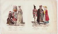
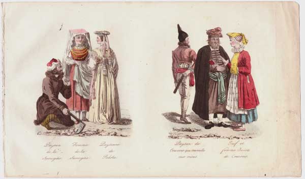
Paysan de la Samogitie. Femme de la Samogitie. Paysanne de la Podolie. Paysan de Cravovie qui travaille aux mines, Juif et femme Juive de Cracovie.
n.d., c.1780.
Coloured etching. Sheet 125 x 210mm (5 x 8½").
A costume plate with two groupings of three people. On the left are a Samogitian peasant and his wife (of Lithuania) and a Podolian woman (Ukraine). On the right are a Polish miner, and a Jewish man and wife of Cracow, Poland.
[Ref: 61471] £90.00
(£108.00 incl.VAT)
![[Ferrol] The Method of Delineating An Harbour.](img-thumbnail/jpegs/61449.jpg)
[Ferrol] The Method of Delineating An Harbour.
Published and S. Dunn, N.º 6. Clements Inn Nov.r 9, 1774.
Engraved map, 18th century watermark. 210 x 320mm (8¼ x 12½"). Paper glued over printed border on left, original binding folds, worm holes.
A detailed chart of Ferrol Harbour, published in a guide to chart making by mathematician & cartographer Samuel Dunn (1723-94).
[Ref: 61449] £140.00
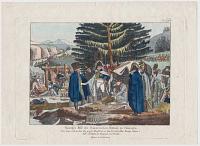
![[Fête de la Fédération] Serment Fédératif du 14 Juillet 1790.](img-thumbnail/jpegs/61482.jpg)
[Fête de la Fédération] Serment Fédératif du 14 Juillet 1790.
Swebach Del. Le Cour sculp.
[n.d., c.1790.]
Very rare aquatint. 430 x 320mm (17 x 12½"). Narrow margins, small split in platemark, creasing.
A view of the Fête de la Fédération, a festival held to celebrate the French Revolution, with a triumphal arch and large altar in the distance where several people are proclaiming their allegiance to the Nation, the Law and (still) the King.
[Ref: 61482] £320.00
![[Ziethen sitzend vor seinem König 1785][in pencil]](img-thumbnail/jpegs/61706.jpg)
[Ziethen sitzend vor seinem König 1785][in pencil] [&][Key plate]
[Chodowiecki][in pencil]
Engraving, sheet 380 x 480mm (15 x 19"). Trimmed within plate and glued to backing sheet, with very scarce keyplate.
One of a pair of scenes from the life of Fredrick the Great. During an audience with his generals Frederick ordered a chair to be brought for the 85-year-old Hans Joachim von Zieten, telling him to sit; when von Zieten refuses to sit in the presence of his monarch, Frederick forces him by threatening to leave. With key plate explaining key figures in the scene. See 33687 for rare proof.
[Ref: 61706] £750.00
view all images for this item
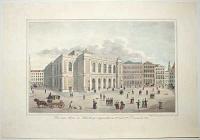
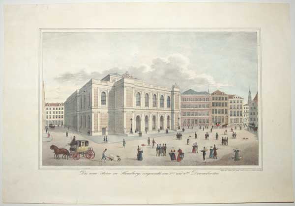
Die neue Borse in Hamburg, eingeweiht am 2ten und 4ten December 1841.
Nach der Natur gez. gedr. und verlegt v. P. Suhr in Hamburg.
[n.d. c.1845]
Rare lithograph with hand colouring. Sheet 335 x 490mm (13¼ x 19¼"). Small tears in margin repaired. Some very light staining.
A view of the "New Stock Exchange" building on the Adolphsplatz, with various pedestrians and carriages passing by.
[Ref: 61500] £320.00
![[Hudson Bay] Carte des Parties du Nord-Ouest de l'Amerique Suivant les Voyages de Middleton et d'Ellis en 1742 et 1746.](img-thumbnail/jpegs/61381.jpg)
[Hudson Bay] Carte des Parties du Nord-Ouest de l'Amerique Suivant les Voyages de Middleton et d'Ellis en 1742 et 1746. Pour chercher un Passage dans la Mer du Sud.
Par M. B. [Bellin] Ing. de la Marine 1753.
[Paris: Didot Libraire, c.1753.]
Engraved map, 18th century watermark. 230 x 290mm (9 x 11½"), large margins. Folded as issued.
A map of the northern part of Hudson Bay, recording the voyages of Christopher Middleton and Henry Ellis in search of the North West Passage. Published in Prevost's 'Histoire Generale des Voyages'.
[Ref: 61381] £230.00
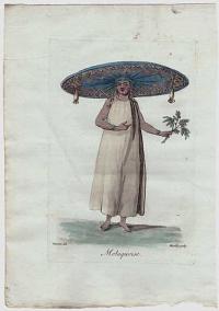
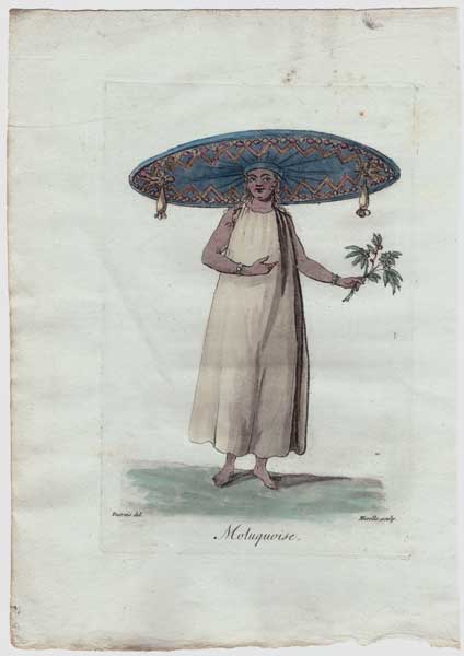
Moluquoise.
Desrais del. Mixelle sculp.
[n.d., c.1784.]
Fine coloured etching. 170 x 115mm (6¾ x 4½"), very large margins.
A woman of the Moluccas, with a very wide-brimmed hat. Engraved by Jean-Marie Mixelle after Claude Louis Desrais (1746-1816) for Jacques Grasset de Saint Sauveur's 'Costumes civiles actuels de tous les peuples connus'.
[Ref: 61451] £95.00
(£114.00 incl.VAT)
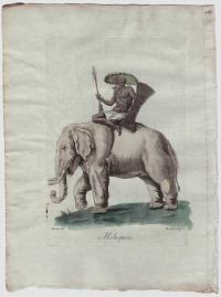
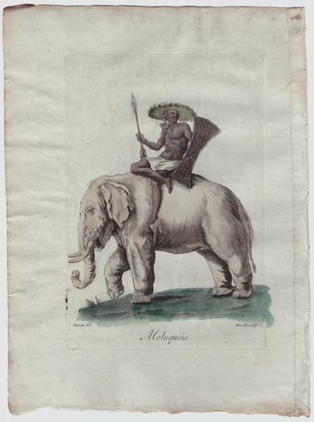
Moluquoise.
Desrais del. Mixelle sculp.
[n.d., c.1784.]
Fine coloured etching. 170 x 115mm (6¾ x 4½"), very large margins.
A warrior of the Moluccas, seated on an elephant, holding a spear and shield. Engraved by Jean-Marie Mixelle after Claude Louis Desrais (1746-1816) for Jacques Grasset de Saint Sauveur's 'Costumes civiles actuels de tous les peuples connus'.
[Ref: 61452] £160.00
(£192.00 incl.VAT)
![[Bothians] Nimna Himna.](img-thumbnail/jpegs/61717.jpg)
[Bothians] Nimna Himna. called by the Men Old Greedy
On Stone by J. Brandard, from the original Drawing by Captain Ross [c.1835]
[London: A. W. Webster, 156 Regent Street, 1835.]
Lithograph, with hand colour. Sheet 235 x 185mm (9¼ x 7¼")
A woman from the Boothia Peninsula, Nunavut, Canada, described by John Ross in his 'Narrative of a Second Voyage in Search of a North-west Passage' (1835), from which this print originates. In his narrative, Ross writes that Nimna Himna 'was a constant visitor to the ship, and generally carried off something which she had picked up. On one occasion, when coming up the ladder, she was tumbled off by the surgeon, and falling on her back, pretended to faint; from which, although all the doctor could do could not recover her, she was restored by the offer of an empty tin case, which had contained preserved meat: a stratagem which she subsequently tried more than once without success. She was about sixty years of age, five feet two inches high, extremely ill-looking, and decidedly the most disgusting of the whole tribe'. Ross was forced by ice to stop at the Boothia peninsula (which he named after his patron Sir Felix Booth) for four years while searching for the north-west passage.
[Ref: 61717] £160.00
(£192.00 incl.VAT)

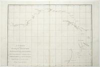
A New Chart of the Vast Atlantic Ocean; exhibiting The Seat of War, both in Europe and America, likewise the Trade Winds & Course of Sailing from one Continent to the other, with the Banks, Shoals and Rocks drawn according to the latest discoveries, and regulated by Astronomical Observations.
Eman.l Bowen Sculp.
Publish'd according to Act of Parliament, for the London Magazine 1755.
Engraved map. 320 x 440mm (12½ x 17¼"). Several repaired tears, with loss of image made up.
A map of the Atlantic, off the Madeiras, covering from southern England in the top right, clockwise to the Slave Coast of Guinea, Cayenne in South America and Newfoundland. Top centre is 'A Table Comparing this Chart with Mr. Popples great Map of the British Empire in America'. This map was first published in 1740, during the War of Jenkins' Ear (1739-48), which was fought over the 'Asiento de Negros', the right for England to sell slaves in Spanish America. Thus the map covers the Triangular Slave Trade. This example was issued just before the outbreak of the Seven Years' War.
[Ref: 61557] £280.00

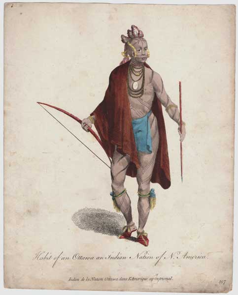
Habit of an Ottawa an Indian Nation of North America. Indien de la Nation Ottawa dans L'Amerique septentrional.
[Thomas Jefferys, n.d., c.1757.]
Hand coloured engraving. Sheet 250 x 200mm (9¾ x 8"). Trimmed within plate, slightly messy.
A full-length portrait of an Odawa warrior, with bow and arrow. Plate 197 from 'Collection of the dresses of different nations, antient [sic] and modern. Particularly old English dresses; after the designs of Holbein, Vandyke, Hollar and others, with an account of the authorities from which the figures are taken, and some short historical remarks on the subject. To which are added the habits of the principal characters on the English stage', published by Thomas Jefferys between 1757 - 1772.
[Ref: 61400] £130.00
(£156.00 incl.VAT)
Opium Smokers and Gamblers. In one of their nightly haunts.
Drawn on the Spot by Sir Harry Darell, Bar.t. On Stone by J.H. Lynch.
London Pub.d May 18 1842 by Mess.rs Colnaghi & Puckle, Printsellers to Her Majesty, to the Queen Dowager, to H.R.H. the Duchess of Kent, &c, 23, Cockspur S.t.
Scarce tinted lithograph. Sheet 355 x 430mm (14 x 17"), large margins on three sides. Bit dusty
The interior of a Chinese opium den. Sir Harry Darell (1814-53), Baronet of Richmond Hill, entered the army as an ensign in the 18th Foot in 1832, becoming lieutenant in 1835. During the First Opium War he was aide-de-camp of Brigadier-General Burrell of the 18th Irish Regiment: he was present at a conference between J.J.Gordon Bremer and Admiral Chang on board HMS Wellesley (4th July 1840, subject of a lithograph by Darell also published 1842, which includes a self-portrait), just prior to the Taking of Chusan, at which he fought. He was promoted to Captain in 1841. He then served in South Africa with the 7th Dragoon Guards, being promoted to Major in 1847, then Lieut-Colonel by brevet the following year. He died in Sardinia. Although he published 'China, India, Cape of Good Hope and Vicinity. A Series of Thirteen Treble-Tinted Views from Sketches by Lieut.-Col. Sir Harry Darell, Bar.t', this plate predates the book by a decade. This plate seems to be a pair to his view of the Chusan Conference.
[Ref: 61234] £550.00
![[Peninsular War] View of the Rio Duero, at Torro,](img-thumbnail/jpegs/61552.jpg)
[Peninsular War] View of the Rio Duero, at Torro, at which place the allied armies united on the commencement of the Campaign of 1813. This Town is famous for Wine & Fruit, great quantity of the latter is sent to Madrid & produced from Standard Trees.
Drawn & Etched by G. Cumberland Jnr.
[n.d., c.1830.]
Coloured etching with extensive watercolour, on 1830 watermarked page. Verso in ink Description of "43d or the Monmouthshire Reg of Foot". Sheet 195 x 310mm (7¾ x 12¼"). Trimmed within plate at top right.
A view of British soldiers marching out of a valley. From the extremely rare series 'Views in Spain and Portugal taken during the campaigns of His Grace the Duke of Wellington'. According to a title-page in BM 'only 30 copies printed'. The artist's father, also George, was a lifelong friend and collaborator of William Blake. See BM 1852,0214.79.
[Ref: 61552] £260.00
(£312.00 incl.VAT)
![[Peninsular War] A bridge one mile from Celorico,](img-thumbnail/jpegs/61553.jpg)
[Peninsular War] A bridge one mile from Celorico, upon the main to Almeida, crossing the river Mondego, an attempt was made by Massena to destroy it in his retreat before the Duke of Wellington in 1811, it is made of granate [sic].
Drawn & Etched by G. Cumberland Jnr.
[n.d., c.1830.]
Coloured etching with extensive watercolour on 1830 watermarked page. Verso in ink Description of "43d or the Monmouthshire Reg of Foot". Sheet 185 x 310mm (7¼ x 12¼"). Trimmed within plate, mounted on album paper.
A view of the damaged bridge, with a British Army tent in the foreground. From the extremely rare series 'Views in Spain and Portugal taken during the campaigns of His Grace the Duke of Wellington'. According to a title-page in BM 'only 30 copies printed'. The artist's father, also George, was a lifelong friend and collaborator of William Blake. BM 1874,0509.84, described as a lithograph.
[Ref: 61553] £260.00
(£312.00 incl.VAT)
Unfortunately this item is either sold or reserved. If you are interested in similar items and cannot find what you're looking for on our website, please consider filling in our interests form. If you register, we can also send you items that match your interests when the website is updated.
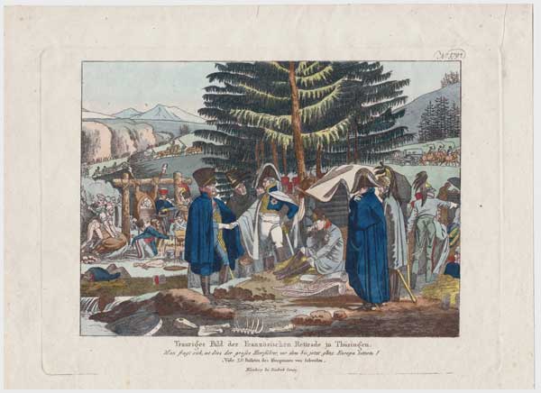
Trauriges Bild der Französischen Retirade in Thüringen. Man fragt sich, ist dies grosse Heerführer, vor dem bis jetzt ganz Europa zitterte? Vide 23. Bulletin des Kronprinzen von Scheden.
Nürnburg bei Friedrich Compe [n.d., c.1814].
Etching with hand colour. 180 x 255mm (7 x 10"), large margins.
Napoleon rests in a bivouac as the Grand Army rests near Erfurt during the Retreat from Moscow in 1812. A propaganda piece, with a title referring to the 'sad state' of the army and continuing 'One asks oneself, is this great military leader before whom all of Europe has trembled until now?'.
[Ref: 61479] £160.00
(£192.00 incl.VAT)
![[Santorini] A View of the Bay of Santerini, with a Burning-Island, which lately rose out of the Sea.](img-thumbnail/jpegs/61416.jpg)
[Santorini] A View of the Bay of Santerini, with a Burning-Island, which lately rose out of the Sea.
Gent. Mag. April 1770.
Engraved map. 185 x 110mm (7¼ x 4¼"). Trimmed to plate on right. Time staining.
A map of Santorini (Thera), with a new volcanic island.
[Ref: 61416] £130.00

The Shade of Napoleon.
[n.d., c.1830.]
Wood engraving. Sheet 145 x 195mm (5¾ x 7¾"). Laid on album paper.
The trunks of two trees create the figure of Napoleon standing by his grave on St Helena.
[Ref: 61446] £160.00
(£192.00 incl.VAT)
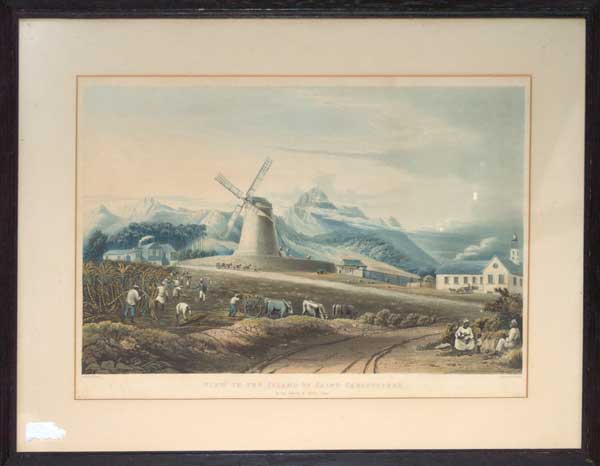
View in the Island of Saint Christopher In The Parish of Nicola Town. Proof.
Drawn by J. Johnson. Engraved by T. Fielding.
[London Published Feb. 1. 1827 by T. & G. Underwood, Fleet Street.]
Fine aquatint, printed in colours and hand finished. Framed, sight size 300 x 435mm (11¾ x 17"). Hand colour faded, framed over publication line? Unexamined out of frame.
A rare view of slaves at work in the cane fields of the Eastridge Estate on the north east side of St Christopher's, with a windmill and mountains behind. From the series 'Views of the West Indies', which was proposed to be five parts. The first two parts were published by the Underwoods in 1827, with a third by Smith & Elder in 1829, before the series was wound up. A map of Antigua and 11 plates were issued. Abbey: 678, ''a pity, for these plates were excellent''.
[Ref: 61568] £520.00
![[Scraps from my sketchbook]](img-thumbnail/jpegs/61506.jpg)
[Scraps from my sketchbook]
C.D. Barraud. Del. G. M.c Cullock Lith.
C.F. Kell Lithographer, Castle S.t Holborn, London. E. C. [1877]
Tinted lithograph, sheet 550 x 425mm (22 x 16¾"), very large margins.
From plate 6 of Barraud's 'New Zealand graphic and descriptive', London, 1877. Showing 14 scenes from Maori life. Reading from top left: Te Raku [Maori man poling a laden canoe along a river]; Whata [Maori provision house on low poles]; Te Rangatira [Maori man o horseback]; Bird catcher; Maori whare [wharenui with carved entrance porch]; Fishmonger; Rubbing noses "Tena-koe" [a man and a woman, both carrying produce, hongi-ing]; Maori hack-race in full costume [horse race by a man wearing nothing but a long shirt and a woman in elaborate hat and European dress]; Maori woman going to a tangi; Going to market [a woman and a man with a child on his back leading a pig]; Travelling [a man in bowler hat and feather cloak leading a horse, accompanied by a dog]; One of the old Wellington Police force [head and shoulders portrait of a man with full moko and Police uniform]; Gathering pipis [women and children on a beach with flat kete digging up seafood]; Te Kiore [a seated man with kiwi feather cloak, moko, a pipe in his mouth, a blanket under the cloak].
[Ref: 61506] £260.00
(£312.00 incl.VAT)

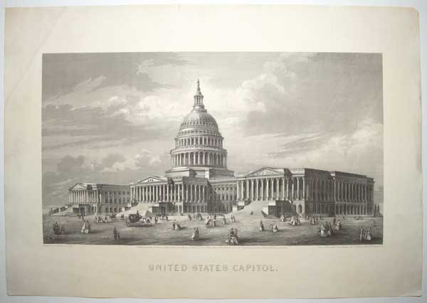
United States Capitol.
Engraved upon Steel by C.E. Loven. From a Photograph of the Drawings by T. U. Walter, Architect, Washington D.C.
Entered, according to Act of Congress, in the year 1866, by A.J. Johnson, in the Clerk's Office of the District Court of the United States for the Southern District of New York.
Steel engraving, sheet 320 x 460mm (12½ x 18"). Trimmed within plate. Repaired Tears. Crease left corner.
A view of the Capitol Building, the seat of the United States Congress, in Washington D.C. Pedestrians, a man on a horse and a carriage all pass by outside. Thomas Ustick Walter (180487) was an American architect of German descent who was the fourth Architect of the Capitol and responsible for adding the north (Senate) and south (House) wings and the central dome.
[Ref: 61498] £220.00
(£264.00 incl.VAT)

A Chart of y.e West-Indies or the Islands of America in the North Sea &c.
By H. Moll Geographer.
[n.d., 1720.]
Engraved map. 285 x 350mm (11¼ x 13¾"). Original binding folds.
A sea chart of the Gulf of Mexico and West Indies, with the eastern coast of North America north to Charleston. It still marks 'New Caledonia', the ill-fated Scottish colony on the Darien Isthmus. From Josiah Burchett's 'A Complete History of the Most Remarkable Transactions at Sea, from the Earliest Account... to the Conclusion of the Last War with France''.
[Ref: 61704] £550.00

A Design for Fortifying Duncannon Fort towards the landside, which can be executed for a less Expence by one Eighth part than the Plan proposed by M.r Skinner. N:B: The Dotted lines represent the form of the old Works as they Stand at present. A. Shews the Barracks and new Buildings how they may be dispos'd.
[n.d., c.1750.]
Section of a manuscript watercolour map. At most 170 x 245mm (6¾ x 9¾"). Old ink mss description on album sheet. With a pen description of the 5 Regiment of Foot verso on 18th century Album page. Trimmed with loss, title excised and pasted on opposite page of album sheets.
A plan for improving the landward defences of Duncannon Fort, a star fort that had been built 1587-88 to defend Waterford from possible invasion by the Spanish Armada. The 'Skinner' mentioned in the title is probably William Skinner (1700-80), who was Chief Royal Engineer from 1757 until his death, working on Gibraltar, St Philip's Castle on Menorca and Fort George near Inverness.
[Ref: 61555] £160.00
![[Wrestlers] Letteurs Suisses.](img-thumbnail/jpegs/61399.jpg)
[Wrestlers] Letteurs Suisses.
D'apres le modèle d'Abart. Grave par F. Hegi.
à Basle dhez Birman & Fils [n.d., c.1830].
Aquatint. Sheet 340 x 250mm (13½ x 9¾"). Trimmed within plate, creasing at top.
A pair of wrestlers grabbing each other's pants. The wrestlers are drawn from a sculpture by South Tyrolean Franz Abart (1769-1863).
[Ref: 61399] £140.00
(£168.00 incl.VAT)

The Zebu Bull. The property of M.r Cross, Exeter Change.
London: William Darton; 58 Holborn Hill. [n.d. c.1815]
Engraving, sheet 240 x 285mm (9½ x 11¼"). Trimmed within plate. A bit of staining in right corner.
A humped cow stands against an outdoor backdrop near a fence, another lies on the ground near a river. The zebu are a domestic cattle originating in South Asia. Edward Cross (1774 1854) was an English zoo proprietor and dealer in animals. He owned the menagerie at the Exeter Exchange from 1814 to its demolition in 1829.
[Ref: 61530] £160.00
(£192.00 incl.VAT)
<<< Previous 1 Next >>>
![[3 September 1843 Revolution]](jpegs/61674.jpg)


![[Asian Heads]](jpegs/61461.jpg)

![[Blenheim] Plan der Roemrugtige Veltslag can Hochstet door de Geallieerde Gewonne op den 13 Augusti 1704.](jpegs/61398.jpg)
![[Bothians] Ikmalick And Apeagliu.](jpegs/61719.jpg)


![[Bothians] Udlia. Awitigin. Palurak.](jpegs/61713.jpg)
![[Bothians] Poyettak. Kakikagiu. Anknalua.](jpegs/61714.jpg)
![[Bothians] Kunana.](jpegs/61715.jpg)
![[Bothians] Shulanina. Tulluachiu, & Tirikshiu.](jpegs/61716.jpg)
![[Bothians] Kawalua. Tiagashu. Adlurak.](jpegs/61718.jpg)


![[Ferrol] The Method of Delineating An Harbour.](jpegs/61449.jpg)
![[Fête de la Fédération] Serment Fédératif du 14 Juillet 1790.](jpegs/61482.jpg)
![[Ziethen sitzend vor seinem König 1785][in pencil]](jpegs/61706.jpg)
![[Hudson Bay] Carte des Parties du Nord-Ouest de l'Amerique Suivant les Voyages de Middleton et d'Ellis en 1742 et 1746.](jpegs/61381.jpg)
![[Bothians] Nimna Himna.](jpegs/61717.jpg)


![[Peninsular War] View of the Rio Duero, at Torro,](jpegs/61552.jpg)
![[Peninsular War] A bridge one mile from Celorico,](jpegs/61553.jpg)
![[Santorini] A View of the Bay of Santerini, with a Burning-Island, which lately rose out of the Sea.](jpegs/61416.jpg)

![[Scraps from my sketchbook]](jpegs/61506.jpg)


![[Wrestlers] Letteurs Suisses.](jpegs/61399.jpg)
