Results 1-15 of 15
<<< Previous 1 Next >>>
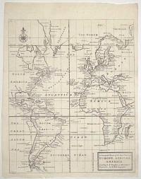
A General Chart of the Sea Coast of Europe, Africa & America. According to E. Wrights or Mercator's Projection.
By H. Moll Geographer.
[n.d., 1720.]
Engraved map. 345 x 285mm (13½ x 11¼"). Original binding folds.
A sea chart centred on the Atlantic Ocean, but also showing all of South America, Africa and the Black Sea. Of interest in the mythical Peypys Island off South America. From Josiah Burchett's 'A Complete History of the Most Remarkable Transactions at Sea, from the Earliest Account... to the Conclusion of the Last War with France''. Edward Wright (1561-1615), a mathmatician and surveyor, not only corrected Mercator's Projection but also published a guide explaining how to use charts using that projection, something that Gerhard Mercator had never done. His work gave British navigators a particular advantage over the competition.
[Ref: 61702] £250.00
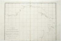
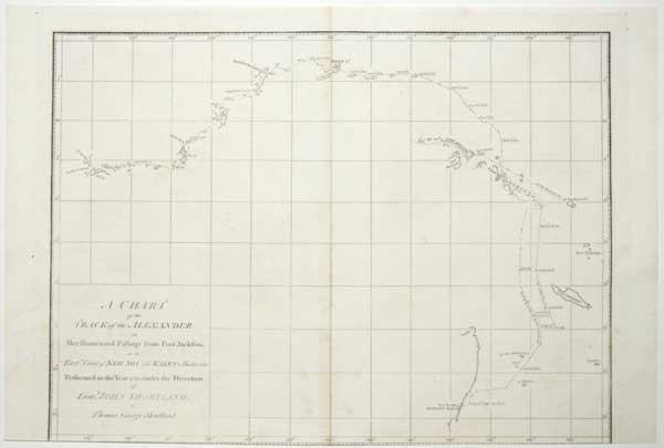
A Chart of the Track of the Alexander on Her Homeward Passage from Port Jackson on the East.n Coast of New South Wales to Batavia; Performed in the Year 1788 under the Direction of Lieut.t John Shortland.
by Thomas George.
[Publish'd as the Act directs by J. Stockdale August 24th 1789.]
Engraved map. 275 x 380mm (10¾ x 15"). Trimmed into printed border at bottom, losing publication line; holes in image filled.
A chart of the return route of the 'Alexander', one of the ships of the First Fleet. It was published in Arthur Phillips 'A Voyage to Botany Bay
'
[Ref: 61705] £220.00
![[Blenheim] Plan der Roemrugtige Veltslag can Hochstet door de Geallieerde Gewonne op den 13 Augusti 1704.](img-thumbnail/jpegs/61398.jpg)
[Blenheim] Plan der Roemrugtige Veltslag can Hochstet door de Geallieerde Gewonne op den 13 Augusti 1704. Plan de la Glorieuse Bataille dHochstet Gagnée Par Les Alliez le 13 Aout 1704.
J. v. Vianen fecit.
[The Hague: Jean Rousset de Missy, 1729.]
Engraved map. 480 x 435mm (19 x 17") very large margins. A few tears in margins, some taped, some spotting.
A plan of the Battle of Blemheim (or Höchstädt, 13th August 1704), in which the Army of the Grand Alliance, led by the Duke of Marlborough and Prince Eugene of Savoy, decisively beat a Franco-Bavarian army that was on route to attack Vienna. From ''Histoire militaire du prince Eugène de Savoie, du prince et duc de Marlborough, et du prince de Nassau-Frise, où l'on trouve un détail des principales actions de la dernière guerre et des batailles et sièges commandez par ces trois généraux''.
[Ref: 61398] £380.00
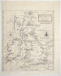
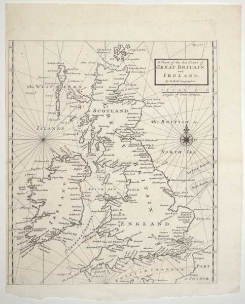
A Chart of the Sea Coast of Great Britain and Ireland.
By H. Moll Geographer.
[n.d., 1720.]
Engraved map. 320 x 285mm (12½ x 11¼"). Narrow margin on left. Original binding folds.
A sea chart of the British Isles, from Josiah Burchett's 'A Complete History of the Most Remarkable Transactions at Sea, from the Earliest Account... to the Conclusion of the Last War with France''.
[Ref: 61703] £380.00

China.
Entered according to act of Congress, in the year 1850, by Thomas Cowperthwait & Co, in the Clerk's office in the District court of the Eastern District of Pennsylvania.
Wood-engraved map with printed colour. Printed area 290 x 360mm (11½ x 14¼"). Tear in margin taped.
A mid-19th century map of China, marking Hong Kong, in fine colour.
[Ref: 61455] £230.00
![[Ferrol] The Method of Delineating An Harbour.](img-thumbnail/jpegs/61449.jpg)
[Ferrol] The Method of Delineating An Harbour.
Published and S. Dunn, N.º 6. Clements Inn Nov.r 9, 1774.
Engraved map, 18th century watermark. 210 x 320mm (8¼ x 12½"). Paper glued over printed border on left, original binding folds, worm holes.
A detailed chart of Ferrol Harbour, published in a guide to chart making by mathematician & cartographer Samuel Dunn (1723-94).
[Ref: 61449] £140.00
![[Hudson Bay] Carte des Parties du Nord-Ouest de l'Amerique Suivant les Voyages de Middleton et d'Ellis en 1742 et 1746.](img-thumbnail/jpegs/61381.jpg)
[Hudson Bay] Carte des Parties du Nord-Ouest de l'Amerique Suivant les Voyages de Middleton et d'Ellis en 1742 et 1746. Pour chercher un Passage dans la Mer du Sud.
Par M. B. [Bellin] Ing. de la Marine 1753.
[Paris: Didot Libraire, c.1753.]
Engraved map, 18th century watermark. 230 x 290mm (9 x 11½"), large margins. Folded as issued.
A map of the northern part of Hudson Bay, recording the voyages of Christopher Middleton and Henry Ellis in search of the North West Passage. Published in Prevost's 'Histoire Generale des Voyages'.
[Ref: 61381] £230.00
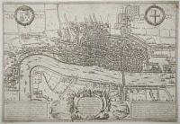
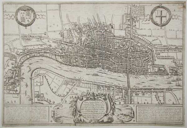
A Plan of London Westm.r and Southwark w.th ye Riv.r Thames, as they were Surveyd and publish't by Authority toward ye latter end of ye Raign of Queen Elizabeth; or about ye year of our Lord 1600. which being compared w.th ye New Map of London ~ The prodigious increase of Building and other alterations of ye names & Situation of Street &c. in this last centry will plainly apperar.
[engraved by Frans Hogenberg.]
[London: Edward Hatton, 1708.]
Engraved map. Sheet 330 x 480mm (13 x 19"). Trimmed close to printed border, laid on card.
The last state of the famed Braun & Hogenberg map of London, originally published in 1572, but showing London before the destruction of the spire of the Norman St Paul's Cathedral in 1561 (during the reign of Mary I). After passing through the hands of publisher Jan Jannson in Amsterdam (who removed the original title and engraved a new cartouche over the original costumes), the plate was bought by a London publisher and used in Hatton's ''A New View of London; or, an Ample Account of that City'', with an English title replacing the Latin. The original issue is the earliest printed map of London to survive. Howgego: 2, state 4.
[Ref: 61721] £1,800.00

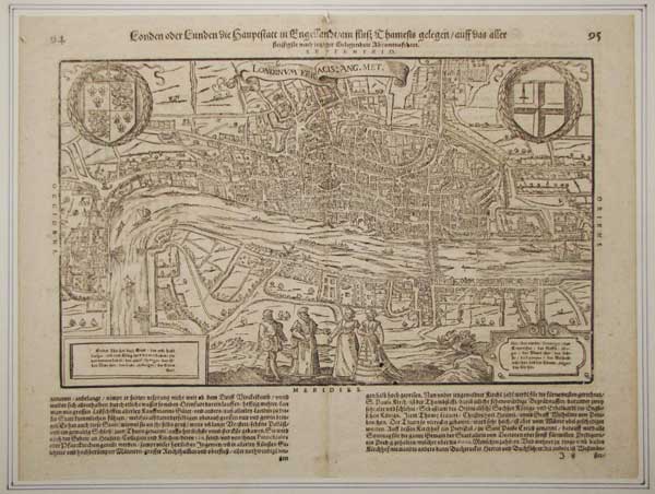
Londinum Feracis: Ang. Met. London oder Lunden die Haupestatt in Engellandt / am fluss Thamesis gelegen...
[Basle: Heinrich Petri, 1614.]
Woodcut map set in letterpress. Sheet 315 x 420mm (12½ x 16½). Printer's crease in letterpress.
A woodcut copy of the famed Braun & Hogenberg map of London of 1572, published in a German edition of Sebastian Münsters Cosmography, the 'Cosmographey oder beschreibung aller Länder, Herrschafften, fürnemmsten Stetten, geschichten, gebreüchen, handtierungen &c.''. Howgego: 6
[Ref: 61722] £1,800.00

A New Chart of the Vast Atlantic Ocean; exhibiting The Seat of War, both in Europe and America, likewise the Trade Winds & Course of Sailing from one Continent to the other, with the Banks, Shoals and Rocks drawn according to the latest discoveries, and regulated by Astronomical Observations.
Eman.l Bowen Sculp.
Publish'd according to Act of Parliament, for the London Magazine 1755.
Engraved map. 320 x 440mm (12½ x 17¼"). Several repaired tears, with loss of image made up.
A map of the Atlantic, off the Madeiras, covering from southern England in the top right, clockwise to the Slave Coast of Guinea, Cayenne in South America and Newfoundland. Top centre is 'A Table Comparing this Chart with Mr. Popples great Map of the British Empire in America'. This map was first published in 1740, during the War of Jenkins' Ear (1739-48), which was fought over the 'Asiento de Negros', the right for England to sell slaves in Spanish America. Thus the map covers the Triangular Slave Trade. This example was issued just before the outbreak of the Seven Years' War.
[Ref: 61557] £280.00
![[Pembroke Gardens] An Exact Survey of the Beautiful & Magnificent](img-thumbnail/jpegs/61711.jpg)
[Pembroke Gardens] An Exact Survey of the Beautiful & Magnificent House Garden & Park of the Right Hon.ble the Earl of Pembroke, With the Ancient Town of Wilton 3 Miles from Salisbury by John Rocque Chorographer to his Royal Highness The Prince of Wales.
Published according to Act of Parliament. Price 2.s 6.d. [1754]
Very rare engraved plan, 18th century watermark; plate 350 x 545mm (13¾ x 21½"), with large margins. Central fold.
Plan of the gardens and grounds at Wilton; the house towards the bottom with more formal gardens and large fish pond to the right, looking out towards the River Nader, and park land beyond; with inset views of the great bridge, the house itself, the arcade, and the porter's lodge on the left, and at top a further view of the bridge from the north. Below on left a plan of the ground floor on a scroll.
[Ref: 61711] £650.00
![[Santorini] A View of the Bay of Santerini, with a Burning-Island, which lately rose out of the Sea.](img-thumbnail/jpegs/61416.jpg)
[Santorini] A View of the Bay of Santerini, with a Burning-Island, which lately rose out of the Sea.
Gent. Mag. April 1770.
Engraved map. 185 x 110mm (7¼ x 4¼"). Trimmed to plate on right. Time staining.
A map of Santorini (Thera), with a new volcanic island.
[Ref: 61416] £130.00

A Chart of y.e West-Indies or the Islands of America in the North Sea &c.
By H. Moll Geographer.
[n.d., 1720.]
Engraved map. 285 x 350mm (11¼ x 13¾"). Original binding folds.
A sea chart of the Gulf of Mexico and West Indies, with the eastern coast of North America north to Charleston. It still marks 'New Caledonia', the ill-fated Scottish colony on the Darien Isthmus. From Josiah Burchett's 'A Complete History of the Most Remarkable Transactions at Sea, from the Earliest Account... to the Conclusion of the Last War with France''.
[Ref: 61704] £550.00

A Design for Fortifying Duncannon Fort towards the landside, which can be executed for a less Expence by one Eighth part than the Plan proposed by M.r Skinner. N:B: The Dotted lines represent the form of the old Works as they Stand at present. A. Shews the Barracks and new Buildings how they may be dispos'd.
[n.d., c.1750.]
Section of a manuscript watercolour map. At most 170 x 245mm (6¾ x 9¾"). Old ink mss description on album sheet. With a pen description of the 5 Regiment of Foot verso on 18th century Album page. Trimmed with loss, title excised and pasted on opposite page of album sheets.
A plan for improving the landward defences of Duncannon Fort, a star fort that had been built 1587-88 to defend Waterford from possible invasion by the Spanish Armada. The 'Skinner' mentioned in the title is probably William Skinner (1700-80), who was Chief Royal Engineer from 1757 until his death, working on Gibraltar, St Philip's Castle on Menorca and Fort George near Inverness.
[Ref: 61555] £160.00

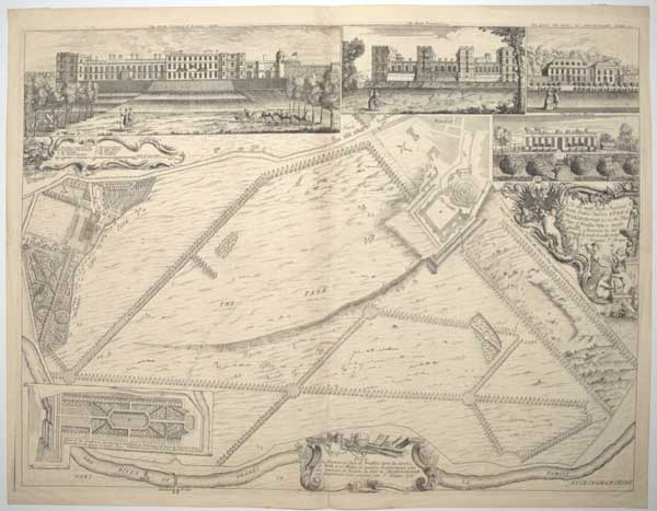
To the most High Puissant & Noble Prince Charles Duke of Marlborough &c: &c: &c: This Plan of Windsor Park is most hum.bly Inscrib'd by His Graces most Devoted * Obe:t hum.ble Servant J: Rocque.
J: Rocque 1738
Very rare engraved plan. 475 x 630mm (18¾ x 24¾"), with margins. Central fold.
Plan of Windsor Castle and gardens, with smaller images on top showing the north view of the castle with cows in the foreground to the right; west view with a couple in the foreground to the left; the Duke of Marlborough's lodge, with a couple in the foreground looking at the house; the greenhouse with a worker in front; large decorative plate with dedication to Prince Charles Duke of Marlborough; and at the bottom the plan of the proposed gardens.
[Ref: 61710] £680.00
<<< Previous 1 Next >>>

![[Blenheim] Plan der Roemrugtige Veltslag can Hochstet door de Geallieerde Gewonne op den 13 Augusti 1704.](jpegs/61398.jpg)

![[Ferrol] The Method of Delineating An Harbour.](jpegs/61449.jpg)
![[Hudson Bay] Carte des Parties du Nord-Ouest de l'Amerique Suivant les Voyages de Middleton et d'Ellis en 1742 et 1746.](jpegs/61381.jpg)

![[Pembroke Gardens] An Exact Survey of the Beautiful & Magnificent](jpegs/61711.jpg)
![[Santorini] A View of the Bay of Santerini, with a Burning-Island, which lately rose out of the Sea.](jpegs/61416.jpg)