Results 1-24 of 24
<<< Previous 1 Next >>>
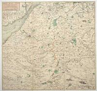
Map of 24 Miles Round the City of Bath, Most humbly dedicated to the Residents and Visitors by their obedient Servant C. Harcourt Masters.
[n.d., c.1812.]
Engraved map with original hand colour. Dissected and laid on linen, as issued, total 590 x 615mm (23¼ x 24¼"), folded into slipcase with old ink mss. title.
A detailed map of the environs of Bath, marking Glastonbury clockwise to Bristol, Newport, Cirencester, Cricklade and Salisbury. Library of Congress, Bath in Time.
[Ref: 59723] £360.00
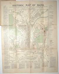
Historic Map of Bath. Indicating the Sites of Public Buildings and Residences of Famous Personages Connected with the History of the City.
Prepared by T. Sturgis Cotterell.
Printed and Published at the Bath Chronicle & Bath Pictorial Offices. Revised to 1898.
Wood engraved map, printed in colours. 570 x 450mm (22½ x 17¾"), folded into original printed boards, adverts on verso. Map with wax stains; covers taped at spine, damped stained.
A tourist's map of Bath, with extensive keys of important sights. Among the list of famous residents are the Henry Fielding, William Herschel, Beau Nash, Frederick Leighton, Thomas Gainsborough and, of course, Jane Austen.
[Ref: 59725] £75.00
![[Untitled map of Bath]](img-thumbnail/jpegs/59729.jpg)
[Untitled map of Bath]
London: G.W. Bacon & Co., Ltd., Norwich St. E.C.4.
[n.d., c.1920.]
Wood-engraved map. Sheet 670 x 830mm (26½ x 32¾"), folded into original cloth covers. Splits in folds, tape stains.
A map of Bath with advertisments for the wine merchants 'Sainsbury Bros.', famous tea and coffee merchants 'Gillards of Bath' and milliners William Rayner. We have dated the map from Bacon's address, which they used 1919-22.
[Ref: 59729] £60.00
![[Repton's design for a dining room for the Royal Pavilion.]](img-thumbnail/jpegs/60097.jpg)
[Repton's design for a dining room for the Royal Pavilion.]
H. Repton Esq.r del. J.C. Stader sculp.
[n.d., c.1825.]
Aquatint, printed in sepia. 185 x 260mm (7¼ x 10¼"), set in letterpress, watermarked 'Turkey Mill 1824'?, very large margins. Scuff mark on right of plate.
Humphry Repton's design for a dining room at the Royal Pavilion, Brighton which, despite having the same Mughal influences, was never implemented. Despite being primarily a landscape designer, Repton (1752-1818) was hired to remodel the Pavilion by the Prince Regent in 1805. The Prince's money problems caused the project to be shelved, but John Nash made use of Repton's proposals when he finally redeveloped the building from 1814.
[Ref: 60097] £230.00
(£276.00 incl.VAT)
Calendarium Londinense or the London Almanack for the Year 1919. The Cenotaph, Whitehall.
London. Published by W. Monk. Drawn Etched and Printed by W. Monk, 118, New Bond Street, W.
Etched image, 180 x 250mm (7 x 9¾"), with calendar underneath, sheet 400 x 290mm (15¾ x 12").
An issue of 'Monk's Calendar', a publication for print collectors founded in 1902 by William Monk (1863-1937) and published yearly until the year 2004. The view shows Whitehall and Lutyens' new Cenotaph, not officially unveiled until 11th November 1920, the second anniversary of the Armistice with Germany.
[Ref: 60103] £240.00
(£288.00 incl.VAT)
![Cary's Traveller's Companion, or, A Delineation of the Turnpike Roads of England & Wales [...]](img-thumbnail/jpegs/59721.jpg)
Cary's Traveller's Companion, or, A Delineation of the Turnpike Roads of England & Wales [...] [with] Cary's New Itinerary: or, An Accurate Delineation of the Great Roads, Both Direct and Cross, Throughout England and Wales; With many of the principal Roads in Scotland.... Second Edition with Improvements.
London. Printed for John Cary, Engraver, Map & Printseller, Strand. 1st Jan.y 1791. [&] London: Printed for John Cary, No. 181 Strand, 1802 [-3].
Two works in one; 8vo (180 x 120mm, 7 x 4¾"), original full diced calf travelling case with empty pockets front and back. 'Companion': engr. title, pp. (iv)+(6)+(2)(ads); index map, 42 maps printed back to back, 1 folding map. 'Itinerary': engr. title & dedication; pp. (iv)+(1)(ad)+868+(2)(ads). All maps with original hand colour. With the bookplate of Henry Pakenham-Mahon of Strokeston Park. Binding with tear to flap, some wear and fading. Folding map of Yorkshire with tear on fold; two folding maps of 'Itinerary' both trimmed to allow opening of segments, one segment loose, with tears on folds.
An unusual travelling edition of two works by John Cary. The 'Traveller's Companion' has a map of England and Wales, 41 counties and maps of North & South Wales. The 'Itinerary' has two road maps of England & Wales, with extensive indexes of the roads. The adverts list some of Cary's maps, with one page dedicated to his globes. The empty pockets in the covers would most likely contain larger folding maps not called for in either the 'Companion' or 'Itinerary'. Henry Pakenham-Mahon (1851-1922) was an amateur photographer: in 2012, a collection of 324 of his glass plates was uncovered at Strokestown Park including several explicit images of live models. Strokestown (in County Roscommon, Ireland) is now home to the National Irish Famine Museum. Henry's grandfather was Denis Mahon, whose responce to a rent strike by his tenants at Strokestown was to evict them and force them to sail to Quebec in 1847, filling four ships. When news came back to Ireland that nearly half the passengers had died on route (primarily from cholera) Mahon was ambushed and shot dead, to general celebration.
[Ref: 59721] £850.00
view all images for this item

Dunotter Castle, Kincardineshire.
Drawn & Engraved by Will.m Daniell.
Published by Mess.rs Longman, & Co. Paternoster Row, & W. Daniell, 9 Cleveland St. Fitzroy Square, London. July, 1, 1822.
Aquatint with hand colour. 230 x 300mm (9 x 12"), very large margins.
A coastal view of the ruined Dunottar Castle, on a cliff top by the sea, with crashing waves below. Dunnottar Castle has played a prominent role in Scottish history because of its strategic location and defensive strength. When Oliver Cromwell's army invaded Scotland the Honours of Scotland (the Scottish crown jewels), were hidden there. From William Daniell's 'A Voyage Round Great Britain', a series of 308 aquatints published in eight volumes between 1814-1825, described by R.V. Tooley as 'the most important colour plate book on British Topography'. Abbey: Scenery, 16; Tooley: Books with Coloured Plates 177.
[Ref: 59806] £190.00
(£228.00 incl.VAT)
![[Foundling Hospital Chapel.] To Sir Charles Whitworth Kn,,t Member of Parliament;](img-thumbnail/jpegs/59650.jpg)
[Foundling Hospital Chapel.] To Sir Charles Whitworth Kn,,t Member of Parliament; Vice President of the Society for the Encouragement of Arts, Manufactures, & Commerce; Treasurer of the Foundling Hospital; &c. &c. &c. this View of the Inside of the Chapel of the Foundling Hospital, is with all due Respect dedicated by his most obedient humble Servant, John Sanders.
J. Sanders, delin et Fait.
Publish'd & Sold by the Author in Great Ormond Street, And at W: Sharp's N.o 9, Bartholomew Lane, according to Act, Jan.y 1774.
Scarce & rare etching. Sheet 385 x 510mm (15¼ x 20"). Trimmed within plate, folds flattened.
A view of the interior of the chapel of Foundling Hospital, looking west, with some of the pupils. Wellcome Library: 23506i.
[Ref: 59650] £420.00
![Geological Survey of England and Wales. Index Map Sheet 11 [Somerset, Wiltshire, Gloucestershire, Oxfordshire and Monmouthshire, etc].](img-thumbnail/jpegs/59730.jpg)
Geological Survey of England and Wales. Index Map Sheet 11 [Somerset, Wiltshire, Gloucestershire, Oxfordshire and Monmouthshire, etc].
Wyman & Sons Ltd. Lith, 63, Carter Lane, 8575.7.96.
Engraved and Published at the Ordnance Survey Office, Southampton, in 1891[-6].
Chromolithographic map. Dissected and laid on linen, as issued, sheet 670 x 905mm (26½ x 35½"), folded into buckram covers with 'G Philip & Son' label with mss. title. Splits in linen.
A colourful geological map, covering from Taunton in the south west, clockwise to Merthyr Tydfil, Hereford, Buckingham, Oxford, Reading, Winchester and Sherbourne. This index sheet covered twelve sheets of the 1 inch series of geological maps.
[Ref: 59730] £260.00
![[Key plates to the Coronation of George IV, Trial of Queen Caroline & Portraits in the House of Lords.]](img-thumbnail/jpegs/60060.jpg)
[Key plates to the Coronation of George IV, Trial of Queen Caroline & Portraits in the House of Lords.]
[After James Stephanoff.]
[Robert Bowyer, n.d., c.1813.]
Etched key plate. Platemark 380 x 495mm (15 x 19½") with thread margins. Two splits in crease where previously folded. Some very light foxing and surface dirt.
Keys to prints published by Bowyer including the Coronation of George IV engraved by Dobourg, and "View of the interior of the House of Lords, during the important investigation in 1820", engraved by Murray, both after James Stephanoff. BM: 1873,0712.562.
[Ref: 60060] £140.00
(£168.00 incl.VAT)
![[Choir of Westminster Abbey during the coronation of His Most Gracious Majesty George the IV, July 10 1821.]](img-thumbnail/jpegs/60048.jpg)
[Choir of Westminster Abbey during the coronation of His Most Gracious Majesty George the IV, July 10 1821.]
[Painted by Frederick Nash. Engraved by Charles Turner.]
[London Published Jan.y 1 1822 by F. Nash, No 40 Mary Street, Fitzroy Square, Mess.rs Colnaghi & Co, Cockspur Street, Hurst & Robinson, Cheapside, & Moltano, Pall Mall.]
Etching. Sheet 545 x 345mm (21½ x 13¾"). Proof before letters. Some spotting and surface dirt. Trimmed.
A scarce and decorative view of the coronation ceremony. Whitman: 798. See 55055 for coloured version with key.
[Ref: 60048] £280.00
(£336.00 incl.VAT)

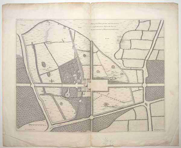
Plan of the Park, Gardens and Plantations of Goodwood in Sussex the Seat of his Grace the Duke of Richmond and Lenox &c.
Ca: Campbell delin: H: Hulsbergh Sculp:
[n.d. c.1731.]
Copper Engraving, 18th century watermark. Plate 375 x 495mm (14¾ x 19½"). Vertical fold through centre as usual. Two small splits in centrefold top and bottom. Some creasing to outer margins.
Garden plan from Henry Hulsbergh's "Vitruvius Brittanicus" series. Goodwood House, West Sussex. The 1st Duke of Richmond, a natural son of Charles II, first rented and then, in 1697, bought the house and park so that he could hunt in the neighbouring village of Charlton, where one of the earliest and most fashionable hunts in the country was based. The 2nd Duke enlarged and modified the existing house using the architect Roger Morris, who was also responsible for the charming banqueting house, Carné's Seat, situated in a commanding position on the hill overlooking Goodwood and its park. The 2nd Duke was very interested in trees, planting up not only High Wood, but also other areas around the house. Some of these trees still survive, including the cork oak trees and cedars of Lebanon.
[Ref: 60053] £180.00
(£216.00 incl.VAT)

The Illustrated Exhibitor. A Tribute to the World's Industrial Jubilee; Comprising Sketches, by Pen and Pencil, of the Principal Objects in the Great Exhibition of the Industry of all Nations. 1851.
London: Printed and Published by John Cassell, 335, Strand. [1851.]
4to, original cloth gilt; pp. xliv + 556, profusely illustrated. Scuffed cover.
An account of the Great Exhibition of 1851 at the Crystal Palace, including the origin of Expositions, the history of the building and the descriptions of its principal objects.
[Ref: 59838] £260.00
(£312.00 incl.VAT)

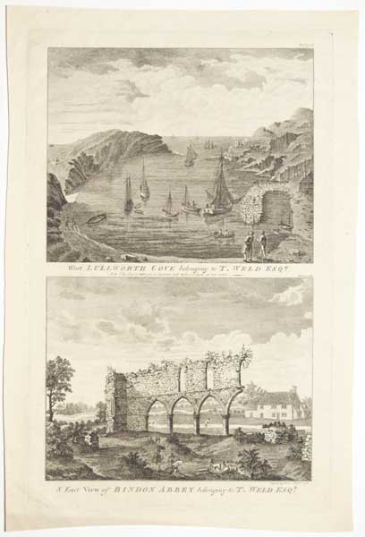
Vol .I.p.163. West Lullworth Cove belonging to T. Weld Esqr. N.B. This Cove is 1380 feet in diameter, and 21 feet in depth at low water. [&] Vol.I.p.130. S. East View of Bindon Abbey belonging to T. Weld Esq.r.
Engrav'd by James Basire. 1773.
Engraving, plate 370 x 235mm (14½ x 9¼"), with large margins. On 18th century watermarked paper. Some cockling.
Two views in Dorset. See also 15747.
[Ref: 60050] £120.00
(£144.00 incl.VAT)
![[Scrap sheet relating to Peerless Pool, including 2 complete adverts.]](img-thumbnail/jpegs/59824.jpg)
[Scrap sheet relating to Peerless Pool, including 2 complete adverts.]
[Various dates, 1746-c.1820]
Eight scraps on one sheet: a pencil sketch, map, etching, two wood engravings & three letterpress extracts. Sheet 680 x 490mm (27 x 19¼"). Scarce. Map trimmed with colour added in places.
In 1743 William Kemp bought a spring-fed pond called Perilous Pond on Old Street, London, and created a pair of stone-edged pools, one for swimming in summer and skating in winter and one for fishing. Originally named for the number of drownings that occured there, he renamed it Peerless Pool and created a very successful business. The map is a section of one sheet of the monumental 24-sheet map of London by John Rocque, 1746.
[Ref: 59824] £360.00
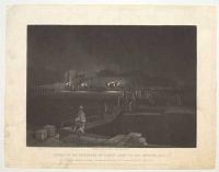
Escort of the Prisoners by Torch Light to the Bristol Jail, Tried (under a Special Commission) for Riot & Arson in the Year 1832.
Engraved on Steel by J. Brett, 15, Corn Street, Bristol.
Published by George Davey 1, Broad Street, Bristol, and by Charles Tilt, Fleet Street, London, and all other Book & Printsellers.
Mezzotint on india laid paper, sheet 235 x 305mm (9¼ x 12"). Some light creasing. Nicks to edges of paper. Slight soiling.
A scene from the aftermath of the Bristol Riots of 1831, after the House of Lords rejected the second Reform Bill, which aimed to get rid of some of the rotten boroughs and give Britain's fast growing industrial towns such as Bristol, Manchester, Birmingham, Bradford and Leeds greater representation in the House of Commons. The rioters numbered about 500 or 600 young men and continued for three days, during which the palace of Robert Gray the Bishop of Bristol, the Mansion House, and private homes and property were looted and destroyed, along with demolition of much of the gaol. About 100 people involved were tried in January 1832 and four men were hanged despite a petition of 10,000 Bristolian signatures, which was given to King William IV. See also reference 15397.
[Ref: 60046] £130.00
(£156.00 incl.VAT)

The Inside View of the Royal Exchange at London. Veue du dedans de la Bourse Royale a Londres.
Bowles Delin et Sculpt.
London, Printed for Bowles and Carver 69 St Paul's Church, R. Wilkinson 58 Cornhill amd Laurie & Whittle 53, Fleet Street [n.d., c.1794].
Coloured engraving. 285 x 425mm (11¼ x 16¾"). A few marks in title, top corners of margins snipped.
A view of the interior courtyard of London's second Royal Exchange, designed by Edward Jerman and opened in 1669, destroyed by fire in 1838.
[Ref: 59819] £240.00
(£288.00 incl.VAT)
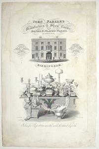
John Parker's Manufactory & Show Rooms, for Silver & Plated Wares, Summer Row, Birmingham. A Splendid assortment of the Most Fashionable Table Servies always on view... Orders for Exportation executed with the utmost dispatch.
W. Green Del. I. Tye Sculp.t.
[n.d., c.1825.]
Rare engraving, J. Whatman 1825 watermark. 355 x 230mm (14 x 9"), large margins. Some restoration.
A large scarce advertisment, with an elevation of the premises and a display of tableware.
[Ref: 59647] £260.00
(£312.00 incl.VAT)

An Improved Map of the County of Somerset Divided into it's Hundreds: Laid down & Collected from the best materials, and illustrated with various additional Improvements; with Historical Extracts relative to its Natural Produce, Trade, Manufactures &c.
By Eman: Bowen, Geographer to His Majesty.
Printed for Carington Bowles in St Pauls Church Yard. Rob.t Sayer in Fleet Street [n.d., c.1767].
Engraved map with original colour. Dissected and laid on linen, probably as issued, total 540 x 720mm (21¼ x 28¼"), with index label on linen. Three old ink stamps from a French library and crayon mss. on map area.
A map of Somerset, surrounded by engraved text and decorated with decorative cartouches for the title & scale and a plan of Bath. It was engraved by Emmanuel Bowen for John Hinton's 'Large English Atlas', the first new large-format county maps in a century. The maps were issued individually, starting in 1749 and completed in 1760, when the full atlas was published. The maps were still available individually, as this example, which is presented as a travel map.
[Ref: 59724] £350.00
Gezigt van den Tuin van Somerset's Paleis, Langs den Theems tot op de Brug van Londen.
[After Canaletto.] C. Philips junior fecit, 1753.
Is. Tirion excudit.
Engraving, 180 x 435mm (7 x 17¼") with large margins. Stained, folding creases as normal, nicks to edges.
Panoramic view from the garden terrace of the Somerset House overlooking the Thames River. St. Paul's Cathedral looms in the background while London Bridge is depicted at far right. This view is based on a painting by Canaletto.
[Ref: 59817] £240.00
(£288.00 incl.VAT)
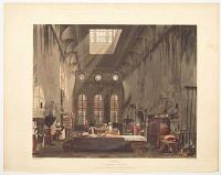
Kitchen. St. James's Palace.
J. Stephanoff del.t. W.J. Bennett sculp.t.
Pub. April 1. 1819 by W.H. Pyne, 30 Upper Charlotte Str.t Fitzroy Sq.e.
Coloured aquatint. 255 x 315mm (10 x 12¼"). Trimmed to plate at bottom. Large margins on 3 sides.
The interior of the kitchen at St. James's Palace, with the cooks and other servants hard at work. After James Stephanoff, illustration to William Henry Pyne's 'The History of the Royal Residences', published in three volumes. See Ref: 27454
[Ref: 60095] £230.00
(£276.00 incl.VAT)

Swanwich Bay, from the North Side. Durlstone Bay. Plate 29.
Drawn by Tho.s Webster. Engraved by George Cooke.
London; Published by Payne & Foss, Pall Mall, 1816.
Rare hand-coloured engraving, J. Whatman watermark 1815. 315 x 475mm (12½ x 18¾"). Folding crease in the middle, some foxing and blue stains. Small margins.
Two panoramic views of Swanage Bay and Durlston Bay, south of Swanage, Dorset. Plate 29 of 'A Description of the principal Picturesque Beauties, Antiquities and Geological Phenomena of the Isle of Wight' by Sir Henry C. Englefield (1816).
[Ref: 59814] £190.00
(£228.00 incl.VAT)
![[Seven untitled views of Tilgate Estate.]](img-thumbnail/jpegs/59925.jpg)
[Seven untitled views of Tilgate Estate.]
[n.d., c1830.]
Seven scarce matching lithographs, most titled in pencil. Various sizes, largest 190 x 230mm.
The woods, ponds and farms of Tilgate Estate, now home to Tilgate Recreational Park.
[Ref: 59925] £250.00
(£300.00 incl.VAT)
view all images for this item

Ancient Kitchen. Windsor Castle.
J. Stephanoff del.t. W.J. Bennett sculp.t.
Pub. Feb.y 1. 1818 by W.H. Pyne, 9 Nasau Street Soho.
Coloured aquatint. 255 x 315mm (10 x 12¼").
The interior of the kitchen at Windsor Castle, with the cooks and other servants hard at work. Excellent kitchen image. After James Stephanoff, illustration to William Henry Pyne's 'The History of the Royal Residences', published in three volumes. See Ref: 60095
[Ref: 60096] £280.00
(£336.00 incl.VAT)
<<< Previous 1 Next >>>


![[Untitled map of Bath]](jpegs/59729.jpg)
![[Repton's design for a dining room for the Royal Pavilion.]](jpegs/60097.jpg)

![Cary's Traveller's Companion, or, A Delineation of the Turnpike Roads of England & Wales [...]](jpegs/59721.jpg)

![[Foundling Hospital Chapel.] To Sir Charles Whitworth Kn,,t Member of Parliament;](jpegs/59650.jpg)
![Geological Survey of England and Wales. Index Map Sheet 11 [Somerset, Wiltshire, Gloucestershire, Oxfordshire and Monmouthshire, etc].](jpegs/59730.jpg)
![[Key plates to the Coronation of George IV, Trial of Queen Caroline & Portraits in the House of Lords.]](jpegs/60060.jpg)
![[Choir of Westminster Abbey during the coronation of His Most Gracious Majesty George the IV, July 10 1821.]](jpegs/60048.jpg)

![[Scrap sheet relating to Peerless Pool, including 2 complete adverts.]](jpegs/59824.jpg)


![[Seven untitled views of Tilgate Estate.]](jpegs/59925.jpg)
