Results 1-7 of 7
<<< Previous 1 Next >>>
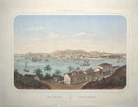
Rio-Janeiro. Rio de Janeiro. Ports de Mer D'Amerique _ Bresil.
Dessiné d'après nature et Lithog. par Deroy.
[Paris: L. Turgis, c.1860.]
Coloured lithograph with fine hand colour. Sheet 440 x 575mm (17¼ x 22¾"), large margins.
A view of Rio de Janeiro from the east side of the harbour, by Isidore Laurent Deroy (1797 - 1886).
[Ref: 59591] £650.00
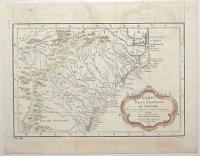
Carte de la Caroline et Georgie. Pour servir à l'Histoire Generale des Voyages.
Tirée des Auteurs Anglois par M.B. Ing. de la Marine. 1757.
[Paris: Didot Libraire, c.1757.]
Engraved map with hand colour, 18th century watermark. 200 x 300mm (8 x 11¾"). Binding folds, four pairs on worm holes in image, two near right plate mark. Offsetting.
A map of the US coastline from Albemarle Sound south to Jekyll Island (near Brunswick in Georgia). It extends inland to the Appalachians and parts of Eastern Tennessee. Published in Prevost's 'Histoire Generale des Voyages'.
[Ref: 59456] £260.00
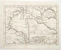
Carte de la Baye de Hudson. Pour servir à l'Histoire Generale des Voyages.
Par M. B. [Bellin] Ing.r de la Mar.e 1757.
[Paris: Didot Libraire, c.1757.]
Engraved map, 18th century watermark. 235 x 315mm (9¼ x 12½"). Narrow right margin, binding folds, slight damp staining.
A map of Hudson Bay and Newfoundland. A note in French top left states that 'the England search for a [North West] passage here but it doesn't exist'. Published in Prevost's 'Histoire Generale des Voyages'.
[Ref: 59459] £130.00
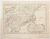
Carte de la Nouvelle Angleterre Nouvelle Yorck et Pensilvanie. Pour servir à l'Histoire Generale des Voyages.
Par M. B. [Bellin] Ing. de la Mar.e 1757.
[Paris: Didot Libraire, c.1757.]
Engraved map, 18th century watermark. 220 x 310mm (8½ x 12¼"). Trimmed to plate upper left by binder, folds with a small tear, 8 worm holes in image.
A map of the Eastern Seaboard from Delaware Bay north to Penobscot, and west to Lake Erie. Published in Prevost's 'Histoire Generale des Voyages'.
[Ref: 59458] £250.00
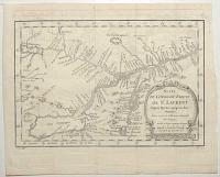
Carte du Cours du Fleuve de St Laurent Depuis Quebec jusqu'au Lac Ontarion. Pour servir à l'Histoire Générale des Voyages.
Par M.B. [Bellin] Ing. de la M.e 1757.
[Paris: Didot Libraire, c.1757.]
Engraved map, 18th century watermark. 210 x 310mm (8¼ x 12¼"). Binding folds, faint ink offset.
Map of the St Lawrence River, showing from Lake Ontario west to Quebec, with Montral and Lake Champelain. It was drawn in 1757 by Jacques Nicolas Bellin for Prevost's 'Histoire'. The Seven Years' War (1756-63) had already started: two years later Quebec fell to the English.
[Ref: 59453] £140.00
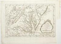
Carte de la Baye de Chesapeack et Pays Voisins. Pour servir à l'Histoire Generale des Voyages. Tirée des meilleures Cartes Angloises.
[Nicolas Bellin.]
[Paris: Didot Libraire, c.1757.]
Engraved map. 210 x 305mm (8¼ x 12"). Trimmed to plate lower right by binder, folds, two worm holes in image.
A map of the environs of Chesapeake Bay, with Virginia, Maryland and part of New Jersey. Published in Prevost's 'Histoire Generale des Voyages'.
[Ref: 59457] £260.00
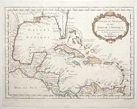
Carte du Golphe du Mexique et des Isles de l'Amerique. Pour servir à l'Histoire Generale des Voyages.
Par M. Bellin Ing.r de la Mar.e 1754.
[Paris: Didot Libraire, c.1757.]
Engraved map with hand colour, 18th century watermark; 290 x 390mm (11½ x 15¼"). Narrow right margin, binding folds, 16 worm holes.
A map of the West Indies and Gulf of Mexico. It marks the mythical island of Bermeja off Yucatan, belief in which lasted until quite recently but not found in a survey in 2009. A current conspiracy theory in Mexico claims that the Central Intelligence Agency destroyed the island to expand the economic zone allotted to the United States. Published in Prevost's 'Histoire Generale des Voyages'.
[Ref: 59460] £480.00
<<< Previous 1 Next >>>