Results 1-7 of 7
<<< Previous 1 Next >>>
![[Arctic.] Polar Regions.](img-thumbnail/jpegs/59113.jpg)
[Arctic.] Polar Regions.
Eng.d by W.H. Lizars.
Published by A. Constable & C.o Edin.r 1822.
Engraved map. Sheet 415 x 390mm (16¼ x 15¼"). paper watermarked 'A. Cowan 1820'. Trimmed within plate, small repaired tear, stains and offset, original binding folds.
A map of the Arctic Circle from Lizars' 'Edinburgh Geographical General Atlas'. In North America the mouths of the Coppermine and McKenzie rivers are shown before the results of John Frankin's expeditions of 1819-22 & 1823.
[Ref: 59113] £190.00

The Plan of Birmingham Survey'd in the Year 1731. To the Honourable Edw.d Digby & Will.m Peyto Esq:rs Members of Parliament for the County of Warwick, this Plate is humbly Dedicated by their most obed.t humble Serv:t W. Westley.
Copied from the Original Engraving and Published by Thomas Underwood, Castle St. High St. Birmingham [n.d., c.1860].
Engraved map. Printed area 400 x 490mm (15¾ x 19¼"), with large margins. Repaired tears.
A Victorian facsimiles of one the first detailed printed map of Birmingham, originally published the year that Samuel and Nathaniel Buck issued their prospect of the city. It names the streets and shows important buildings in perspective. The Corn Market next to St. Martins Church is now the Bull Ring. Underneath are statistics for the city: in 1700 it contained 30 streets, 100 courts and alleys, 2,504 houses and 15032 inhabitants; by 1730 there were 25 additional streets, 50 courts and alleys, 1252 houses and 8254 inhabitants, representing a doubling in size. William Westley, a local surveyor, owned land in the city's south-easst, commemorated with Westleys Row.
[Ref: 59156] £280.00
![[Columbia] Plan of the Harbour of Carthagena.](img-thumbnail/jpegs/59319.jpg)
[Columbia] Plan of the Harbour of Carthagena.
T. Jefferys sculp.
[n.d., c.1768.]
Engraved map. 210 x 315mm (8¼ x 12½"), large margins. Slight mount burn.
A plan of Cartagena, the important Spanish port colony in Colombia, a frequent target of British attacks, particularly that of Admiral Vernon in 1741. This uncommon map was published in 'General Topography of North America and the West Indies' by Thomas Jefferys (c.1719-71).
[Ref: 59319] £350.00
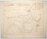
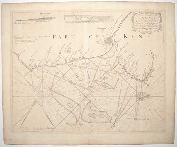
A Large Draught of the Downes Shewing the Sands Shoales Depths of Water and Anchorage with all the Leading marks to Avoide the Dangers therein surveyed by Cap.t. W.m Nunn.
[Engraved by James Mynde.]
Sold by W.m Mount & T. Page on Tower Hill [n.d., c.1750].
Engraved map. 435 x 550mm (17¼ x 21¾"), on thick paper, very large margins. Paper toned.
A detailed chart of the Kent coast from Dover Castle to Margate, orientated with north to the right. An important feature is Goodwin Sands, the 10-mile-long sandbank responsible for the loss of over 2,000 ships. This map was first published by Samuel Thornton in 1723; this example was published by Mount & Page in their re-issue of the Greenvile Collins's 'Great Britain Coasting Pilot'.
[Ref: 59320] £350.00
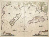
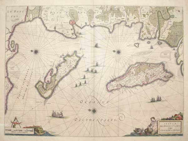
Insulæ Divi Martini et Uliarus Vulgo L'Isle de Ré et Oleron.
[Amsterdam: Johannes Blaeu, c.1650, French text edition.]
Engraved map with original hand colour. 395 x 540mm (15½ x 21¼"), large margins.
A sea chart of Ile de Ré and Oleron, orientated with north to the left, decorated with coloured cartouches for the title and scale. The adjacent coastline is also shown, with La Rochelle.
[Ref: 45599] £350.00
![[Robinson Crusoe's Island.]](img-thumbnail/jpegs/59235.jpg)
[Robinson Crusoe's Island.]
Clark & Pine Sc. 1719.
[n.d., c.1908.]
Photo-etching. 230 x 350mm (9 x 13½"), watermarked 'Michallet'.
A pictorial map of Crusoe's island, also known as the 'Island of Despair', showing various incidents from Daniel Defoe's novel. A copy of the plate originally published in the third edition of Defoe's series titled, 'Serious Reflections during the Life and Surprising Adventures of Robinson Crusoe', London printed by W. Taylor.
[Ref: 59235] £85.00
(£102.00 incl.VAT)
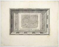
Plan du Labirinthe de Versailles.
A Liede, Chez Pierre Vander Aa, Marchand Libraire [n.d., 1728].
Engraved map with separately-engraved printed border. Total 220 x 330mm (8¾ x 13"), with large margins. Split in inner plate mark, damp stain in margin.
A plan of the hedge maze grown in the Gardens of Versailles, laid out 1672-7. The thirty-nine fountains, each representing one of the fables of Aesop, are numbered, unfortunately without a key. From Pieter van der Aa's monumental 66-volume 'Galerie Agréable du Monde', noted for the additional frame-like borders around each plate. It is said only one hundred copies were printed. See Ref: 26900
[Ref: 59196] £180.00
<<< Previous 1 Next >>>
![[Arctic.] Polar Regions.](jpegs/59113.jpg)

![[Columbia] Plan of the Harbour of Carthagena.](jpegs/59319.jpg)
![[Robinson Crusoe's Island.]](jpegs/59235.jpg)
