Results 1-37 of 37
<<< Previous 1 Next >>>
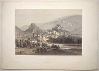
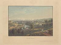
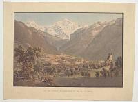
Sion. (Canton du Valais.) La Suisse et la Savoie. 18.
Photographié par Martens. Lithographié par Eug. Cicéri. Imp. Lemercier, Paris.
Publié par Goupil et C.e le 1.r Avril 1860. Paris, London. Berlin. Verlag von Goupil & C.e. New York. Published by M. Knoedler.
Tinted lithograph. Sheet 400 x 570mm (15¾ x 22½"), with Goupil's blind stam, very large margins.
A view of Sion, in the Canton of Valais. Plate 18 of 'La Suisse et la Savoie par Eugène Ciceri d'après les vues photographiées par Martens, photographe de S.M. l'Empereur' (1859-65), which recorded 'numerous locations still unknown or little known in topographical illustration' (Gattlen). In 1844 Frédéric Martens (1809-75) had been sent to Chamonix by the French government to experiment with photography in extreme conditions, producing some of the first photographs of the high alps. In the early 1850s he exhibited panoramic views in London and Paris, fuelling interest in the scenery of the region, so returned for this series. As his medium, daguerreotype, prevented easy reproduction, his images had to be lithographed (by Étienne Eugène Cicéri) for publication. Anton Gattlen, 'L'Estampe topographique ou valais 1850-1899 et supplement 1600-1849', p.86.
[Ref: 59054] £180.00
(£216.00 incl.VAT)
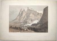
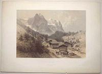
Grindelwald. (Canton de Berne). La Suisse et la Savoie. 3.
Photographié par Martens. Lithographié par Eug. Cicéri. Imp. Lemercier Paris.
Publié par Goupil et C.e le 1.er Avril 1860 [-1865]. Paris, Londres. Berlin ... Verlag von Goupil & C.e. New York. Published by M. Knoedler.
Tinted lithograph. Sheet 400 x 570mm (15¾ x 22½"), with Goupil's blind stamp, large margins. A little scuffing, repaired tears in bottom margin below publication line & top above title.
A view of Grindelwald, with the Wetterhorn and the end of the Upper Grindelwald Glacier. Plate 3 of 'La Suisse et la Savoie par Eugène Ciceri d'après les vues photographiées par Martens, photographe de S.M. l'Empereur' (1859-65), which recorded 'numerous locations still unknown or little known in topographical illustration' (Gattlen). In 1844 Frédéric Martens (1809-75) had been sent to Chamonix by the French government to experiment with photography in extreme conditions, producing some of the first photographs of the high alps. In the early 1850s he exhibited panoramic views in London and Paris, fuelling interest in the scenery of the region, so returned for this series. As his medium, daguerreotype, prevented easy reproduction, his images had to be lithographed (by Étienne Eugène Cicéri) for publication. Anton Gattlen, 'L'Estampe topographique ou valais 1850-1899 et supplement 1600-1849', p.86.
[Ref: 58926] £180.00
(£216.00 incl.VAT)

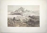
L'Eiger. (Canton de Berne.) La Suisse et la Savoie. 43.
Photographié par Martens. Lithographié par Eug. Cicéri. Imp. Lemercier Paris.
Publié par Goupil et C.e le 1.er Avril 1861. Paris, London. Berlin. Verlag von Goupil & C.e. New York. Published by M. Knoedler.
Tinted lithograph. Sheet 570 x 400mm (22½ x 15¾"), with Goupil's blind stamp, very large margins.
A view of the Eiger, in the Canton of Bern, with tourists walking on the mountain river bank. Plate 43 of 'La Suisse et la Savoie par Eugène Ciceri d'après les vues photographiées par Martens, photographe de S.M. l'Empereur' (1859-65), which recorded 'numerous locations still unknown or little known in topographical illustration' (Gattlen). In 1844 Frédéric Martens (1809-75) had been sent to Chamonix by the French government to experiment with photography in extreme conditions, producing some of the first photographs of the high alps. In the early 1850s he exhibited panoramic views in London and Paris, fuelling interest in the scenery of the region, so returned for this series. As his medium, daguerreotype, prevented easy reproduction, his images had to be lithographed (by Étienne Eugène Cicéri) for publication. Anton Gattlen, 'L'Estampe topographique ou valais 1850-1899 et supplement 1600-1849', p.86.
[Ref: 59040] £260.00
(£312.00 incl.VAT)
Glacier des Bossons. Chamonix (Savoie). La Suisse et la Savoie. 15.
Photographié par Martens. Lithographié par Eug. Cicéri. Imp. Lemercier Paris.
Publié par Goupil et C.e le 1.er Avril 1860 [-1865]. Paris, Londres. Berlin ... Verlag von Goupil & C.e. New York. Published by M. Knoedler.
Tinted lithograph. Sheet 400 x 570mm (15¾ x 22½"), with Goupil's blind stamp, large margins. A little scuffing, a colour mark in image.
Bossons Glacier, in the Mont Blac massif, with tourists walking on the moraine. Plate 15 of 'La Suisse et la Savoie par Eugène Ciceri d'après les vues photographiées par Martens, photographe de S.M. l'Empereur' (1859-65), which recorded 'numerous locations still unknown or little known in topographical illustration' (Gattlen). In 1844 Frédéric Martens (1809-75) had been sent to Chamonix by the French government to experiment with photography in extreme conditions, producing some of the first photographs of the high alps. In the early 1850s he exhibited panoramic views in London and Paris, fuelling interest in the scenery of the region, so returned for this series. As his medium, daguerreotype, prevented easy reproduction, his images had to be lithographed (by Étienne Eugène Cicéri) for publication. Anton Gattlen, 'L'Estampe topographique ou valais 1850-1899 et supplement 1600-1849', p.86.
[Ref: 58925] £280.00
(£336.00 incl.VAT)

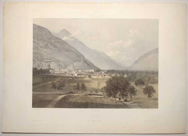
Martigny. (Canton du Valais.) La Suisse et la Savoie. 40.
Photographié par Martens. Lithographié par Eug. Cicéri. Imp. Lemercier Paris.
Publié par Goupil et C.e le 1.er Avril 1861. Paris, London. Berlin. Verlag von Goupil & C.e. New York. Published by M. Knoedler.
Tinted lithograph. Sheet 400 x 570mm (15¾ x 22½"), with Goupil's blind stamp, very large margins. Slightly scuffed top left. Pinhole in building on left.
A view of Martigny, in the Canton of Valais. Plate 40 of 'La Suisse et la Savoie par Eugène Ciceri d'après les vues photographiées par Martens, photographe de S.M. l'Empereur' (1859-65), which recorded 'numerous locations still unknown or little known in topographical illustration' (Gattlen). In 1844 Frédéric Martens (1809-75) had been sent to Chamonix by the French government to experiment with photography in extreme conditions, producing some of the first photographs of the high alps. In the early 1850s he exhibited panoramic views in London and Paris, fuelling interest in the scenery of the region, so returned for this series. As his medium, daguerreotype, prevented easy reproduction, his images had to be lithographed (by Étienne Eugène Cicéri) for publication. Anton Gattlen, 'L'Estampe topographique ou valais 1850-1899 et supplement 1600-1849', p.86.
[Ref: 59042] £180.00
(£216.00 incl.VAT)

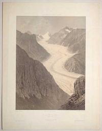
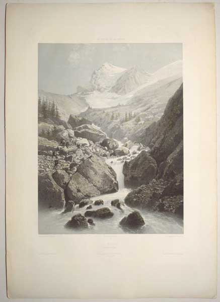
Glacier de Rosenlaui. (Canton de Berne.) La Suisse et la Savoie. 5.
Photographié par Martens. Lithographié par Eug. Cicéri. Imp. Lemercier Paris.
Publié par Goupil et C.e le 1.er Avril 1859. Paris, London. Berlin. Verlag von Goupil & C.e. New York. Published by M. Knoedler.
Tinted lithograph. Sheet 570 x 400mm (22½ x 15¾"), with Goupil's blind stamp, very large margins. Slightly scuffed, nick and tear on right margin
A view of the Glacier of Rosenlaui, in the Canton of Berne, with people crossing the moraine and the glacier. Plate 5 of 'La Suisse et la Savoie par Eugène Ciceri d'après les vues photographiées par Martens, photographe de S.M. l'Empereur' (1859-65), which recorded 'numerous locations still unknown or little known in topographical illustration' (Gattlen). In 1844 Frédéric Martens (1809-75) had been sent to Chamonix by the French government to experiment with photography in extreme conditions, producing some of the first photographs of the high alps. In the early 1850s he exhibited panoramic views in London and Paris, fuelling interest in the scenery of the region, so returned for this series. As his medium, daguerreotype, prevented easy reproduction, his images had to be lithographed (by Étienne Eugène Cicéri) for publication. Anton Gattlen, 'L'Estampe topographique ou valais 1850-1899 et supplement 1600-1849', p.86.
[Ref: 59048] £290.00
(£348.00 incl.VAT)
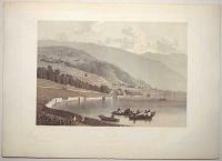
Montreux. (Canton de Vaud.) La Suisse et la Savoie. 26.
Photographié par Martens. Lithographié par Eug. Cicéri. Imp. Lemercier Paris.
Publié par Goupil et C.e le 1.er 8.bre 1859. Paris, London. Berlin. Verlag von Goupil & C.e. New York. Published by M. Knoedler.
Tinted lithograph. Sheet 400 x 570mm (15¾ x 22½"), with Goupil's blind stamp, very large margins. Some spots.
A view of Montreux and Lake Geneva, in the Canton of Vaud. Plate 26 of 'La Suisse et la Savoie par Eugène Ciceri d'après les vues photographiées par Martens, photographe de S.M. l'Empereur' (1859-65), which recorded 'numerous locations still unknown or little known in topographical illustration' (Gattlen). In 1844 Frédéric Martens (1809-75) had been sent to Chamonix by the French government to experiment with photography in extreme conditions, producing some of the first photographs of the high alps. In the early 1850s he exhibited panoramic views in London and Paris, fuelling interest in the scenery of the region, so returned for this series. As his medium, daguerreotype, prevented easy reproduction, his images had to be lithographed (by Étienne Eugène Cicéri) for publication. Anton Gattlen, 'L'Estampe topographique ou valais 1850-1899 et supplement 1600-1849', p.86.
[Ref: 59050] £160.00
(£192.00 incl.VAT)
Le Glacier de Viesch. (Canton du Valais.) La Suisse, la Savoie et le Tyrol. 81.
Photographié par Martens. Lithographié par Eug. Cicéri. Imp. Lemercier, 57. R. de Seine, Paris.
Publié par Goupil et C.e le 1.r Octobre 1862. Paris, Londres, La Haye. Berlin. Verlag von Goupil & C.e. New York. Published by M. Knoedler.
Tinted lithograph. Sheet 570 x 400mm (22½ x 15¾"), with Goupil's blind stamp, very large margins. Some spots, two wormholes.
A view of the Fiescher Glacier, in the Canton of Valais. Plate 81 of 'La Suisse et la Savoie par Eugène Ciceri d'après les vues photographiées par Martens, photographe de S.M. l'Empereur' (1859-65), which recorded 'numerous locations still unknown or little known in topographical illustration' (Gattlen). In 1844 Frédéric Martens (1809-75) had been sent to Chamonix by the French government to experiment with photography in extreme conditions, producing some of the first photographs of the high alps. In the early 1850s he exhibited panoramic views in London and Paris, fuelling interest in the scenery of the region, so returned for this series. As his medium, daguerreotype, prevented easy reproduction, his images had to be lithographed (by Étienne Eugène Cicéri) for publication. Anton Gattlen, 'L'Estampe topographique ou valais 1850-1899 et supplement 1600-1849', p.86.
[Ref: 59051] £280.00
(£336.00 incl.VAT)
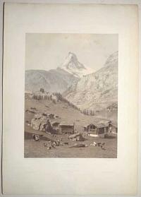
Le Mont Cervin. (Canton du Valais.) La Suisse et la Savoie. 13.
Photographié par Martens. Lithographié par Eug. Cicéri. Imp. Lemercier, Paris.
Publié par Goupil et C.e le 1.r Avril 1859. Paris, London. Berlin. Verlag von Goupil & C.e. New York. Published by M. Knoedler.
Tinted lithograph. Sheet 570 x 400mm (22½ x 15¾"), with Goupil's blind stamp, very large margins. Some surface dirt.
A view of the Matterhorn, in the Canton of Valais, from a valley with goats being herded in the foreground. Plate 13 of 'La Suisse et la Savoie par Eugène Ciceri d'après les vues photographiées par Martens, photographe de S.M. l'Empereur' (1859-65), which recorded 'numerous locations still unknown or little known in topographical illustration' (Gattlen). In 1844 Frédéric Martens (1809-75) had been sent to Chamonix by the French government to experiment with photography in extreme conditions, producing some of the first photographs of the high alps. In the early 1850s he exhibited panoramic views in London and Paris, fuelling interest in the scenery of the region, so returned for this series. As his medium, daguerreotype, prevented easy reproduction, his images had to be lithographed (by Étienne Eugène Cicéri) for publication. Anton Gattlen, 'L'Estampe topographique ou valais 1850-1899 et supplement 1600-1849', p.86.
[Ref: 59053] £280.00
(£336.00 incl.VAT)
Vue Prise au Dessous de Rosenlaui. (Canton de Berne.) La Suisse et la Savoie. 6.
Photographié par Martens. Lithographié par Eug. Cicéri. Imp. Lemercier, Paris.
Publié par Goupil et C.e le 1.er Avril 1859. Paris, London. Berlin. Verlag von Goupil & C.e. New York. Published by M. Knoedler.
Tinted lithograph. Sheet 400 x 570mm (15¾ x 22½"), with Goupil's blind stamp, very large margins. Crease and nick on margins, some spots.
A view of the Glacier of Rosenlaui, in the Canton of Berne, from a valley with people walking on the path. Plate 6 of 'La Suisse et la Savoie par Eugène Ciceri d'après les vues photographiées par Martens, photographe de S.M. l'Empereur' (1859-65), which recorded 'numerous locations still unknown or little known in topographical illustration' (Gattlen). In 1844 Frédéric Martens (1809-75) had been sent to Chamonix by the French government to experiment with photography in extreme conditions, producing some of the first photographs of the high alps. In the early 1850s he exhibited panoramic views in London and Paris, fuelling interest in the scenery of the region, so returned for this series. As his medium, daguerreotype, prevented easy reproduction, his images had to be lithographed (by Étienne Eugène Cicéri) for publication. Anton Gattlen, 'L'Estampe topographique ou valais 1850-1899 et supplement 1600-1849', p.86.
[Ref: 59055] £240.00
(£288.00 incl.VAT)
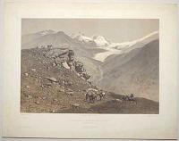
Le Strahlhorn et le Glacier de Findelin. (Canton du Valais.) La Suisse, la Savoie et le Tyrol. 80.
Photographié par Martens. Lithographié par Eug. Cicéri. Imp. Lemercier, 57. R. de Seine, Paris.
Publié par Goupil et C.e le 1.er Avril 1859. Paris, London. Berlin. Verlag von Goupil & C.e. New York. Published by M. Knoedler.
Tinted lithograph. Sheet 385 x 495mm (15¼ x 19½"), with Goupil's blind stamp, very large margins. Slightly scuffed and foxed, some coloured spots.
A view of the Strahlhorn and Findel Glacier, in the Canton of Valais, with people and mules in the foreground. Plate 80 of 'La Suisse et la Savoie par Eugène Ciceri d'après les vues photographiées par Martens, photographe de S.M. l'Empereur' (1859-65), which recorded 'numerous locations still unknown or little known in topographical illustration' (Gattlen). In 1844 Frédéric Martens (1809-75) had been sent to Chamonix by the French government to experiment with photography in extreme conditions, producing some of the first photographs of the high alps. In the early 1850s he exhibited panoramic views in London and Paris, fuelling interest in the scenery of the region, so returned for this series. As his medium, daguerreotype, prevented easy reproduction, his images had to be lithographed (by Étienne Eugène Cicéri) for publication. Anton Gattlen, 'L'Estampe topographique ou valais 1850-1899 et supplement 1600-1849', p.86.
[Ref: 59056] £260.00
(£312.00 incl.VAT)
Les Alpes Bernoises. (Canton de Berne.) La Suisse et la Savoie. 47.
Photographié par Martens. Lithographié par Eug. Cicéri. Imp. Lemercier, Paris.
Publié par Goupil et C.e le 1.r Avril 1861. Paris, London. Berlin. Verlag von Goupil & C.e. New York. Published by M. Knoedler.
Tinted lithograph. Sheet 400 x 570mm (15¾ x 22½"), with Goupil's blind stamp, very large margins. Small tears and creases on margins, some spots on image.
A view of the Bernese Alps, in the Canton of Berne, with people riding horses in the foreground and cattle in the middle ground. Plate 47 of 'La Suisse et la Savoie par Eugène Ciceri d'après les vues photographiées par Martens, photographe de S.M. l'Empereur' (1859-65), which recorded 'numerous locations still unknown or little known in topographical illustration' (Gattlen). In 1844 Frédéric Martens (1809-75) had been sent to Chamonix by the French government to experiment with photography in extreme conditions, producing some of the first photographs of the high alps. In the early 1850s he exhibited panoramic views in London and Paris, fuelling interest in the scenery of the region, so returned for this series. As his medium, daguerreotype, prevented easy reproduction, his images had to be lithographed (by Étienne Eugène Cicéri) for publication. Anton Gattlen, 'L'Estampe topographique ou valais 1850-1899 et supplement 1600-1849', p.86.
[Ref: 59057] £260.00
(£312.00 incl.VAT)
Lausanne. (Canton de Vaud.) La Suisse et la Savoie. 37.
Photographié par Martens. Lithographié par Eug. Cicéri. Imp. Lemercier, Paris.
Publié par Goupil et C.e le 1.r Avril 1861. Paris, London. Berlin. Verlag von Goupil & C.e. New York. Published by M. Knoedler.
Tinted lithograph. Sheet 400 x 570mm (15¾ x 22½"), with Goupil's blind stamp, very large margins. Nicks and colour stains on outer margins on right.
A view of Lausanne, in the Canton of Vaud, with Lake Geneva in the background. Plate 37 of 'La Suisse et la Savoie par Eugène Ciceri d'après les vues photographiées par Martens, photographe de S.M. l'Empereur' (1859-65), which recorded 'numerous locations still unknown or little known in topographical illustration' (Gattlen). In 1844 Frédéric Martens (1809-75) had been sent to Chamonix by the French government to experiment with photography in extreme conditions, producing some of the first photographs of the high alps. In the early 1850s he exhibited panoramic views in London and Paris, fuelling interest in the scenery of the region, so returned for this series. As his medium, daguerreotype, prevented easy reproduction, his images had to be lithographed (by Étienne Eugène Cicéri) for publication. Anton Gattlen, 'L'Estampe topographique ou valais 1850-1899 et supplement 1600-1849', p.86.
[Ref: 59058] £220.00
(£264.00 incl.VAT)
Berne. (Canton de Berne.) La Suisse et la Savoie. 20.
Photographié par Martens. Lithographié par Eug. Cicéri. Imp. Lemercier, Paris.
Publié par Goupil et C.e le 1.r Avril 1860. Paris, London. Berlin. Verlag von Goupil & C.e. New York. Published by M. Knoedler.
Tinted lithograph. Sheet 400 x 570mm (15¾ x 22½"), with Goupil's blind stamp, very large margins. Repaired nick and tears on margins, some spots.
A view of the Old City of Bern, bordered on three sides by the river Aare. Plate 20 of 'La Suisse et la Savoie par Eugène Ciceri d'après les vues photographiées par Martens, photographe de S.M. l'Empereur' (1859-65), which recorded 'numerous locations still unknown or little known in topographical illustration' (Gattlen). In 1844 Frédéric Martens (1809-75) had been sent to Chamonix by the French government to experiment with photography in extreme conditions, producing some of the first photographs of the high alps. In the early 1850s he exhibited panoramic views in London and Paris, fuelling interest in the scenery of the region, so returned for this series. As his medium, daguerreotype, prevented easy reproduction, his images had to be lithographed (by Étienne Eugène Cicéri) for publication. Anton Gattlen, 'L'Estampe topographique ou valais 1850-1899 et supplement 1600-1849', p.86.
[Ref: 59060] £260.00
(£312.00 incl.VAT)
Le Lac Moerill and le Glacier d'Aletsch. (Canton du Valais.) La Suisse, la Savoie et le Tyrol. 79.
Photographié par Martens. Lithographié par Eug. Cicéri. Imp. Lemercier, 57. R. de Seine, Paris.
Publié par Goupil et C.e le 1.r Octobre 1862. Paris, Londres, La Haye. Berlin. Verlag von Goupil & C.e. New York. Published by M. Knoedler.
Tinted lithograph. Sheet 385 x 505mm (15¼ x 20"), with Goupil's blind stamp, very large margins. Colour stains on image, slightly foxed on top margin.
A view of the Aletsch Glacier, in the Canton of Valais, and the glacial lake Märjelen. Plate 79 of 'La Suisse et la Savoie par Eugène Ciceri d'après les vues photographiées par Martens, photographe de S.M. l'Empereur' (1859-65), which recorded 'numerous locations still unknown or little known in topographical illustration' (Gattlen). In 1844 Frédéric Martens (1809-75) had been sent to Chamonix by the French government to experiment with photography in extreme conditions, producing some of the first photographs of the high alps. In the early 1850s he exhibited panoramic views in London and Paris, fuelling interest in the scenery of the region, so returned for this series. As his medium, daguerreotype, prevented easy reproduction, his images had to be lithographed (by Étienne Eugène Cicéri) for publication. Anton Gattlen, 'L'Estampe topographique ou valais 1850-1899 et supplement 1600-1849', p.86.
[Ref: 59061] £260.00
(£312.00 incl.VAT)

Zurich. (Canton de Zurich.) La Suisse et la Savoie. 38.
Photographié par Martens. Lithographié par Eug. Cicéri. Imp. Lemercier, Paris.
Publié par Goupil et C.e le 1.r Avril 1861. Paris, London. Berlin. Verlag von Goupil & C.e. New York. Published by M. Knoedler.
Tinted lithograph. Sheet 400 x 570mm (15¾ x 22½"), with Goupil's blind stamp, very large margins. Repaired nick and colour stain on margins, scuffing and some spots on top right.
A view of Zürich from the river Limmat. Plate 38 of 'La Suisse et la Savoie par Eugène Ciceri d'après les vues photographiées par Martens, photographe de S.M. l'Empereur' (1859-65), which recorded 'numerous locations still unknown or little known in topographical illustration' (Gattlen). In 1844 Frédéric Martens (1809-75) had been sent to Chamonix by the French government to experiment with photography in extreme conditions, producing some of the first photographs of the high alps. In the early 1850s he exhibited panoramic views in London and Paris, fuelling interest in the scenery of the region, so returned for this series. As his medium, daguerreotype, prevented easy reproduction, his images had to be lithographed (by Étienne Eugène Cicéri) for publication. Anton Gattlen, 'L'Estampe topographique ou valais 1850-1899 et supplement 1600-1849', p.86.
[Ref: 59062] £240.00
(£288.00 incl.VAT)
Vue de Berne.
F. Schmid del. J. Hurlimann sc.
a Neuchatel chez Jeanneret & Baumann [n.d. c.1840]
Coloured aquatint, plate 165 x 210mm (6½ x 8¼"), with large margins. A small amount of creasing in margins. Some time staining inside the plate mark.
A view of Bern, Switzerland, from a hill. Cows graze in the foreground being eatched over by milkmen and a milkmaid, the river Aare winds round the field and the city sits against a backdrop of the Alps.
[Ref: 58781] £160.00
(£192.00 incl.VAT)
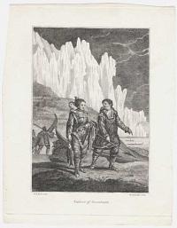
Natives of Greenland.
W.H. Brown del. Thornthwaite sculp.
[London: J. Debrett, 1800.]
Engraving. 210 x 165mm (8¼ x 6½"). Trimmed to plate on two sides, narrow margins elsewhere.
From the English edition of Jacques Labillardière's ''An Account of A Voyage in search of La Perouse... Under the Command of Rear-Admiral Bruni d'Entrecasteaux'', an expedition that crossed the South Pacific, visiting Australia, New Zealand and the East Indies between 1791-3.
[Ref: 58737] £95.00
(£114.00 incl.VAT)
![[Hawaii] Sandwich Islands.](img-thumbnail/jpegs/58947.jpg)
[Hawaii] Sandwich Islands.
W.m Bligh del.t.
[London: Nichol & Cadell, 1784.]
Engraving. Sheet 200 x 425mm (8 x 16¾"). Trimmed within plate, folded twice as normal.
Six coastal profiles of the islands of Hawaii, as seen by the crew of the Resolution, Captain James Cook's ship on his Third Voyage, the first Europeans to reach the islands in January 1778. Two of the profiles are attributed to William Bligh, who was Master of the Resolution, priot to becoming captain of the Bounty.
[Ref: 58947] £220.00
(£264.00 incl.VAT)
![[Portrait of Chinese mandarin Hesing (Xi Sheng).]](img-thumbnail/jpegs/58948.jpg)
[Portrait of Chinese mandarin Hesing (Xi Sheng).] Sept 12th 1848. Keying. Hesing.
Scarce wood engraved portrait, signed and dated in ink mss, in both Roman and Chinese characters, with two Chinese stamps in red ink. 190 x 125mm (7½ x 5"). Laid on album paper, some staining.
A signed portrait of a Chinese mandarin who travelled aboard the 'Keying', a three-masted junk purchased in secrecy by British businessmen in Hong Kong, defying a Chinese law prohibiting the sale of Chinese ships to foreigners. She left Hong Kong in December 1846, rounding the Cape of Good Hope and becoming the first junk to visit New York in July 1847. Keying left for Britain in February and, despite being damaged in a storm, made the crossing in 21 days, a short period even for the American packet-ships. This portrait was published as a souvenir of the visit of the Keying to London, where it was visited by Queen Victoria. See Ref 43257.
[Ref: 58948] £950.00
![[Italian Landscape.]](img-thumbnail/jpegs/58997.jpg)
[Italian Landscape.] 29.
P. Bril Inventor. Nieulant fecit.
A Bon enfant excud. Avec Privilege du Roy. [n.d. c.1605.]
Etching, plate 240 x 315mm (9½ x 12½"). Trimmed to plate on three sides and glued on album sheet. Slightly stained on inscription area, one wormhole.
Italian landscape with people resting in the foreground and two figures walking down a hill in the background. This is Plate 29 from a series of thirty-six plates showing Italian landscapes after Paul Bril by Willem van Nieulandt. See Hollstein: 76-111.
[Ref: 58997] £260.00
(£312.00 incl.VAT)

The Ice Castle Winter Carnival Montreal 1889.
A. Sabiston & Co. Lith. Montreal.
Suppliment Montreal Star Carnival Number. (Copyrighted). [n.d. c.1889]
Coloured chromolithograph, sheet 390 x 560mm (15¼ x 22"). Laid on board. Central crease. Tears to margins. Surface dirt. Staining. Messy but colour bright.
A view of a grand ice castle topped with eight flags one dramatically printed outside the main image. The palace is surrounded by people on horse drawn sleighs. The the Montreal Winter Carnival was designed to entice tourists to Quebec in Winter. From 1883 to 1889, five such carnivals were organized. The Ice Palace was a fundamental part of the carnivals. The ice palaces of 1883, 1884, 1885, 1887, and probably 1889 were designed by leading architect Alexander Cowper Hutchinson and built at least in 1883 by his brother J.H. Hutchinson.
[Ref: 58923] £190.00
(£228.00 incl.VAT)
![[Nan'an] Nangan. [&] A Chinese Sepulcher.](img-thumbnail/jpegs/58668.jpg)
[Nan'an] Nangan. [&] A Chinese Sepulcher.
[Wenceslaus Hollar]
[London: John Ogilby, 1669.]
Two etchings, mounted on album paper back to back. Each sheet c.105 x 170mm (4¼ x 6¾") Trimmed to plate.
Two views: a view of a junk on a river at Nan'an, a suburb of Ganzhou; and a view of a tomb cut into the side of a hill, with a funeral procession. Etched by Wenceslaus Hollar for John Ogilby's 'An Embassy from the East-India Company of the United Provinces', the first English edition of Johan Nieuhof's account of the embassy. Pennington 1159 & 2389.
[Ref: 58668] £160.00
(£192.00 incl.VAT)
view all images for this item
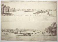
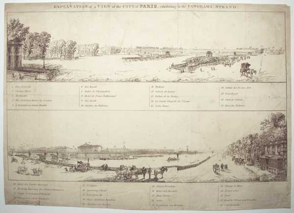
Explanation of a View of the City of Paris, exhibiting in the Panorama, Strand.
[n.d., c.1826.]
Etched keyplate. Sheet 305 x 425mm (12 x 16¾"). Original folds, old repairs, slight soiling and creasing.
The keyplate to a panorama of Paris from the Place de la Concord (here named 'Place Louis 16', used 1826-30), exhibited at the Panorama in the Strand, London. Thomas Edward Barker, son of the Robert Barker who coined the word 'panorama', opened a rival exhibition site with artist Ramsay Richard Reinagle in 1801, at 168-9 The Strand. See: Ref: 56281, 53539 & 59116
[Ref: 58762] £180.00
(£216.00 incl.VAT)
![[Nuova pianta et alzata della citta di Roma...] 5.](img-thumbnail/jpegs/58690.jpg)
[Nuova pianta et alzata della citta di Roma...] 5.
[Diegniata et Intagliata da Gio. Battista Falda.]
[Rome: Giovanni Giacomo de Rossi 1676, but later.]
Engraved map, one sheet only (of twelve), 17th century watermark. 395 x 505mm (15½ x 19¾") very large margins. Damp stains. Central crease as normal.
Sheet 5 of a 12-sheet map of Rome by Giovanni Battista Falda da Valdugga (1648-78), an architect who drew and engraved views of Rome for the de Rossi family. It takes the form of a bird's-eye view, with buildings shown in perspective. Orientated with north to the left, this section shows the Colosseum, the Forum, Campidoglio, the Palatine Hill and the Baths of Trajan.
[Ref: 58690] £480.00
![[Nuova pianta et alzata della citta di Roma...] 11.](img-thumbnail/jpegs/58691.jpg)
[Nuova pianta et alzata della citta di Roma...] 11.
[Diegniata et Intagliata da Gio. Battista Falda.]
[Rome: Giovanni Giacomo de Rossi 1676, but later.]
Engraved map, one sheet only (of twelve), 17th century watermark. 395 x 505mm (15½ x 19¾"), very large margins. Central crease as normal.
Sheet 11 of a 12-sheet map of Rome by Giovanni Battista Falda da Valdugga (1648-78), an architect who drew and engraved views of Rome for the de Rossi family. It takes the form of a bird's-eye view, with buildings shown in perspective. As the map was orientated with north to the left, this section shows the Janiculum walls, built by Urban VIII in 1643, centred on the Porta San Pancrazio. Under the map is a panel containing nine views of churches, including the Basilicas of St Peter & St Paul.
[Ref: 58691] £320.00
![Nuova pianta et alzata della [citta di Roma...] 1.](img-thumbnail/jpegs/58688.jpg)
Nuova pianta et alzata della [citta di Roma...] 1.
[...] Diegniata et Intagliata da Gio. Battista [Falda.]
[Rome: Giovanni Giacomo de Rossi 1676, but later.]
Engraved map, one sheet only (of twelve). 395 x 505mm (15½ x 19¾") very large margins. Margin snipped bottom right.
The top left sheet of a 12-sheet map of Rome by Giovanni Battista Falda da Valdugga (1648-78), an architect who drew and engraved views of Rome for the de Rossi family. It takes the form of a bird's-eye view, with buildings shown in perspective. As the map was orientated with north to the left, this section shows the north east of Rome, with the Porta Viminale & Porta Collina in the Servian Walls, and the Via Salaria and Via Nomentana. This sheet is decorated with an ornate border on two sides, allegorical figures of the Papacy and Roman Law, and two cherubs holding up the papal mitre and arms.
[Ref: 58688] £220.00
![[Nuova pianta et alzata della citta di Roma...] 4.](img-thumbnail/jpegs/58689.jpg)
[Nuova pianta et alzata della citta di Roma...] 4.
[Diegniata et Intagliata da Gio. Battista Falda.]
[Rome: Giovanni Giacomo de Rossi 1676, but later.]
Engraved map, one sheet only (of twelve). 395 x 505mm (15½ x 19¾") very large margins Central crease as normal.
Sheet 4 of a 12-sheet map of Rome by Giovanni Battista Falda da Valdugga (1648-78), an architect who drew and engraved views of Rome for the de Rossi family. It takes the form of a bird's-eye view, with buildings shown in perspective. As the map was orientated with north to the left, this section shows the north edge of Rome, with the Porta Popolo on the Via Flamina, and the Piazza del Popolo and Piazza Barbarini. This sheet is decorated with a dedication to Pope Innocent XI, on a scroll held aloft by two cherubs.
[Ref: 58689] £350.00
![[Urbis Romae Sciographia Ex Antiquis Monumentis Accuratiss Delineata.]](img-thumbnail/jpegs/58694.jpg)
[Urbis Romae Sciographia Ex Antiquis Monumentis Accuratiss Delineata.]
[after Pirro Ligorio.]
[Rome: Giovanni Giacomo de Rossi, c.1650.]
Engraved map, one sheet of eight, 17th century watermark. 530 x 420mm (21 x 16½") very large margins. Central crease as normal.
Plate '9' of a monumental eight-sheet plan (numbered 2-5, 8-11) of Ancient Rome, based on the detailed archaeological survey by Pirro Ligorio (c.1510-83), a scholar of the ancient monuments. The map is constructed as a bird's-eye view, with the buildings illustrated, and shows the west of the city, including the mausoleums of Hadrian and Augustus, the Antonine Column, the Pantheon, the Theatre of Marcellus and the Temple of Asclepius, shaped like a ship on the Tiberina. First published by Etienne Duperac in 1574, this example comes from a 17th century reissue by De Rossi.
[Ref: 58694] £420.00
![[Urbis Romae Sciog]raphia Ex Antiquis Monum[entis Accuratiss Delineata.]](img-thumbnail/jpegs/58692.jpg)
[Urbis Romae Sciog]raphia Ex Antiquis Monum[entis Accuratiss Delineata.]
[after Pirro Ligorio.]
[Rome: Giovanni Giacomo de Rossi, c.1650.]
Engraved map, one sheet of eight, 17th century watermark. 530 x 420mm (21 x 16½") very large margins Tears, creasing and damp stains in margins. Central crease (short tear) as normal.
Plate three of a monumental eight-sheet plan of Ancient Rome, based on the detailed archaeological survey by Pirro Ligorio (c.1510-83), a scholar of the ancient monuments. The map is constructed as a bird's-eye view, with the buildings illustrated, and shows the north-east of the city, including the Baths of Diocletian and the barracks of the Praetorian guard. First published by Etienne Duperac in 1574, this example comes from a 17th century reissue by De Rossi.
[Ref: 58692] £280.00
![[Urbis Romae Sciographia Ex Antiquis Monumentis Accuratiss] Delineata.](img-thumbnail/jpegs/58695.jpg)
[Urbis Romae Sciographia Ex Antiquis Monumentis Accuratiss] Delineata.
[after Pirro Ligorio.]
[Rome: Giovanni Giacomo de Rossi, c.1650.]
Engraved map, one sheet of eight, 17th century watermark 530 x 420mm (21 x 16½") very large margins. Hole bottom right. Central crease as normal.
Plate 5 of a monumental eight-sheet plan of Ancient Rome (numbered 2-5, 8-11), based on the detailed archaeological survey by Pirro Ligorio (c.1510-83), a scholar of the ancient monuments. The map is constructed as a bird's-eye view, with the buildings illustrated, and shows land outside city walls to the east, including funerary munuments, estates, the Appian Way and the aqueducts Appia, Claudia and Marcia. First published by Etienne Duperac in 1574, this example comes from a 17th century reissue by De Rossi.
[Ref: 58695] £280.00
![[Urbis Romae Sciographia Ex Antiquis Monum]entis Accuratiss [Delineata.]](img-thumbnail/jpegs/58693.jpg)
[Urbis Romae Sciographia Ex Antiquis Monum]entis Accuratiss [Delineata.]
[after Pirro Ligorio.]
[Rome: Giovanni Giacomo de Rossi, c.1650.]
Engraved map, one sheet of eight. 530 x 420mm (21 x 16½") very large margins. Tears and creasing in margins. Central crease as normal. Slight loss in margin bottom left.
Plate four of a monumental eight-sheet plan of Ancient Rome, based on the detailed archaeological survey by Pirro Ligorio (c.1510-83), a scholar of the ancient monuments. The map is constructed as a bird's-eye view, with the buildings illustrated, and shows the east of the city, including the Porta Esquilina, the Aqua Claudia aqueduct, Amphitheatrum Castrense and, outside the city walls, the 'Hippodrome of Aurelius', of which there is no written record. First published by Etienne Duperac in 1574, this example comes from a 17th century reissue by De Rossi.
[Ref: 58693] £350.00
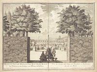
Vüe du Jardin des Nains de Mirabell à Salsbourg du coté du Midi. 6.
Cum Priv. S.C.M. leveé et dessiné par Francois Antoine Danreiter. I. A. Corvinus sculp.
[n.d. c.1735.]
Engraving and etching, sheet 245 x 330mm (9¾ x 13"). Trimmed within plate and glued on album sheet. Folded along central crease, some creases, surface dirt on inscription area.
View of the gardens of Mirabell Palace in Salzburg, after Franz Anton Danreiter (1695-1760). Dwarf statues are located on the both sides of the main walking path.
[Ref: 58982] £160.00
(£192.00 incl.VAT)

Silk Reeling. Che.kiang
Fr Schenck. 50 Geo. St Edin. [n.d. c.1860]
Hand coloured lithograph, sheet 125 x 190mm (5 x 7½"). Bottom margin slightly creased.
A country scene in Zhejiang (Chekiang), China of people making silk thread. One person checks mulberry leaves for silkworm cocoons, another sits creating bundles perhaps for twig frames for the silkworms, one person guides the thread onto the wheel that winds it onto spools, with another person turning. Someone watches from a window nearby and two older people watch them closely. Chickens peck at the ground.
[Ref: 58995] £140.00
(£168.00 incl.VAT)
Vue de Château d'Unspunnen et de ses environs.
[After Gabriel Lory le père][Engraver Johann Hurlimann].
[n.d. c.1822.]
Hand coloured aquatint, pt J. Whatman watermark, sheet 250 x 330mm (9¾ x 13"). Trimmed within platemark. Some creases and spots on image.
A landscape view of the ruins of Unspunnen Castle and its surroundings, in the canton of Bern in Switzerland. The scene depicts a valley with snowy peaks in the distance, the Unspunnen Castle on the right and some houses and cows in the middle ground. A group of three figures resting in the left foreground.
[Ref: 58903] £320.00
![[Vienna] Ansicht des Platzes und der Kirche von S.t Peter.](img-thumbnail/jpegs/58738.jpg)
[Vienna] Ansicht des Platzes und der Kirche von S.t Peter. Vue de la Place et de L'Eglise de S. Pierre.
dessiné et gravé d'apres nature par C. Shütz.
Cum Priv. S.C.M. [Vienna: Artaria c.1805.]
Etching with fine hand colour. 335 x 440mm (13¼ x 17¼").
A view of the Peterskirche, a Baroque Roman Catholic parish church, built 1701-33. It is now run by Opus Dei.
[Ref: 58738] £330.00
![[Vienna] Der Hohemarkt.](img-thumbnail/jpegs/58739.jpg)
[Vienna] Der Hohemarkt. Vue du Haut Marché.
Nach der Natur gezeichnet und gestochen von C. Shütz.
Wein, bey Artaria u. Comp. [n.d., c.1793.]
Etching with fine hand colour. Sheet 415 x 425mm (12½ x 16¾"). Trimmed within plate, glue stains at corners, repaired tear top left. Central crease.
A view of Hoher Markt Square, Vienna, with the 'Vermählungsbrunnen' (The Marriage Fountain), a baroque, white marble temple based on a drawing by Joseph Emanuel Fischer von Erlach, consecrated 1732.
[Ref: 58739] £320.00
<<< Previous 1 Next >>>


![[Hawaii] Sandwich Islands.](jpegs/58947.jpg)
![[Portrait of Chinese mandarin Hesing (Xi Sheng).]](jpegs/58948.jpg)
![[Italian Landscape.]](jpegs/58997.jpg)

![[Nan'an] Nangan. [&] A Chinese Sepulcher.](jpegs/58668.jpg)
![[Nuova pianta et alzata della citta di Roma...] 5.](jpegs/58690.jpg)
![[Nuova pianta et alzata della citta di Roma...] 11.](jpegs/58691.jpg)
![Nuova pianta et alzata della [citta di Roma...] 1.](jpegs/58688.jpg)
![[Nuova pianta et alzata della citta di Roma...] 4.](jpegs/58689.jpg)
![[Urbis Romae Sciographia Ex Antiquis Monumentis Accuratiss Delineata.]](jpegs/58694.jpg)
![[Urbis Romae Sciog]raphia Ex Antiquis Monum[entis Accuratiss Delineata.]](jpegs/58692.jpg)
![[Urbis Romae Sciographia Ex Antiquis Monumentis Accuratiss] Delineata.](jpegs/58695.jpg)
![[Urbis Romae Sciographia Ex Antiquis Monum]entis Accuratiss [Delineata.]](jpegs/58693.jpg)


![[Vienna] Ansicht des Platzes und der Kirche von S.t Peter.](jpegs/58738.jpg)
![[Vienna] Der Hohemarkt.](jpegs/58739.jpg)