Results 1-27 of 27
<<< Previous 1 Next >>>
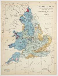
England and Wales with the Channel Islands and parts of Scotland Ireland and France.
[James Reynolds, London 1863]
Hand coloured engraving, sheet 240 x 185mm (9½ x 7¼"). Folded as issued, time staining along taped fold.
From 'Reynolds's Geological Atlas of Great Britain'. A geological map of Britain with the land colour coded by rock type.
[Ref: 56924] £30.00
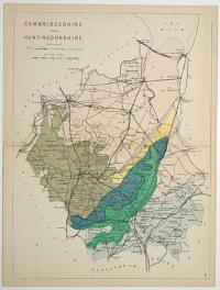
Cambridgeshire and Huntingdonshire. Railways. 4.
[James Reynolds, London 1863]
Hand coloured engraving, sheet 240 x 185mm (9½ x 7¼"). Folded as issued, time staining along fold.
From 'Reynolds's Geological Atlas of Great Britain'. A map of the railways showing ones under constuction and stations.
[Ref: 56925] £40.00
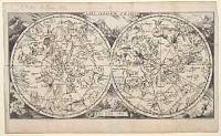
Plani Sperium Coeleste.
[Engraved by Jan Peeters]
[Antwerp, 1692.]
Engraving. 150 x 285mm (6 x 11¼"), large margins. Some creasing as normal.
A double-hemisphere celestial map, with allegorical figures of the bodies of the Solar System in the corners and cusps. From ''L'Atlas en Abrege, ou Nouvelle Description du Monde''.
[Ref: 56823] £160.00
![[Celestial Hemispheres] The First Part of the Northern Celestial Hemisphere. [&]](img-thumbnail/jpegs/56837.jpg)
[Celestial Hemispheres] The First Part of the Northern Celestial Hemisphere. [&] The Second Part of the Northern Celestial Hemisphere. [&] The First Part of the So.n Celestial Hemisphere. [&] The Second Celestial Hemisphere.
J. Mynde sculp. [on one plate.]
[London, c.1760.]
Set of four engravings with hand colour. Each c. 155 x 295mm. All plates with binding folds, 2nd plate with damp and damage top right.
Four plates making up the two celestial hemispheres, with the constellations in their classic shapes. From volume 4 of 'Spectacle de la Nature: Or Nature Display'd. Being Discourses on Such Particulars of Natural History as Were Thought Most Proper to Excite the Curiosity and Form the Minds of Youth', an English edition of a work by Noël Antoine Pluche.
[Ref: 56837] £500.00
view all images for this item
![[Pair of Celestial Hemisheres] Northern Hemisphere. [&] Sothern Hemisphere.](img-thumbnail/jpegs/57036.jpg)
[Pair of Celestial Hemisheres] Northern Hemisphere. [&] Sothern Hemisphere.
J. Shury sc.
[London: Thomas Tegg, 1826.]
Two engravings with hand colour. Two sheets each 150 x 165mm (6 x 6½"). Trimmed and laid on album paper.
A pair of celestial hemispheres, with the classical depictions of the constellations.
[Ref: 57036] £140.00
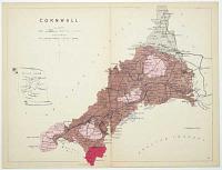
Cornwall. Railways. 6.
[James Reynolds, London 1863]
Hand coloured engraving, sheet 185 x 240mm ( 7¼ x 9½"). Folded as issued, time staining along fold.
From 'Reynolds's Geological Atlas of Great Britain'. A map of the railways showing ones under constuction and stations.
[Ref: 56926] £40.00
![[Untitled map of the path of the 1764 Solar Eclipse]](img-thumbnail/jpegs/56817.jpg)
[Untitled map of the path of the 1764 Solar Eclipse]
Gent. Mag. 1764.
Engraved map. 185 x 115mm.
A map of the path of the 1764 solar eclipse across northern France and south east England. Three disks show how much of the sun was obscured in Bologne (total), Orleans & London (almost total) 6.
[Ref: 56817] £120.00

Essex. Railways. 13.
[James Reynolds, London 1863]
Hand coloured engraving, sheet 185 x 240mm ( 7¼ x 9½"). Folded as issued, time staining along fold.
From 'Reynolds's Geological Atlas of Great Britain'. A map of the railways showing ones under constuction and stations.
[Ref: 56927] £40.00
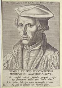
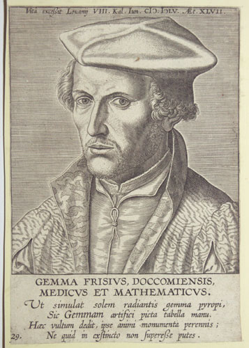
Gemma Frisivs, Doccomiensis, Medicvs et Mathematicvs. Ut simulat solem radiantis gemma pyropi, Sic Gemmam artifici picta tabella manu. Haec vultum dedit, ipse animi monumenta perennis; Ne quid in exstincto non Superebe putes. 29. Vita excebit Louany VII. Kal. Iun. CIC. ICLV. Aet. XLVII.
[After Jan van Stalburch]
[n.d., c1620]
Engraving, sheet 220 x 135mm (8¾ x 5¼"). Trimmed and glued to backing sheet.
Head and shoulders portrait of Gemma Frisius with an excerpt from Melchior Adam's (c. 1575 1622) 'Vitae Germanorum medicorum' (1620). Gemma Frisius (born Jemme Reinerszoon; 1508 1555) was a Dutch physician, mathematician, cartographer, philosopher, and instrument maker. He created important globes, improved the mathematical instruments of his day and applied mathematics in new ways to surveying and navigation. The astronomical rings known as Gemma's rings are named after him.
[Ref: 57144] £140.00
(£168.00 incl.VAT)
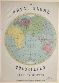
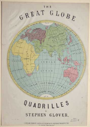
The Great Globe Quadrilles by Stephen Glover
[S. Rosenthal lith.]
London: Robert Cocks & C.o New Burlington S.t Regent S.t W. [n.d. c.1870]
Colour lithograph. 330 x 240mm (13 x 9½"). Trimmed with creasing in the top left corner and a small repaired tear in the upper left margin. Two worm holes in top left and bottom right corners.
An illustrated cover of the Eastern hemisphere for the sheet music to Stephen Glover's 'Quadrilles'.
[Ref: 56908] £190.00
(£228.00 incl.VAT)

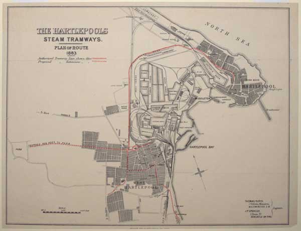
The Hartlepools Steam Tramways. Plan of Route 1883.
Waterlow Bro.s & Layton, Birchin Lane London.
[c.1883.]
Wood engraved map, overprinted in red. Sheet 310 x 400mm (12¼ x 15¾"). Original folds.
'The Hartlepools Steam Tramways' opened in 1884, running from Northgate in Hartlepool to Church Road in West Hartlepool. The company folded in 1891, after which the assets were purchased by 'Hartlepool Electric Tramways', who electrified the system and reopened in 1896, lasting until 1927.
[Ref: 56706] £160.00
(£192.00 incl.VAT)
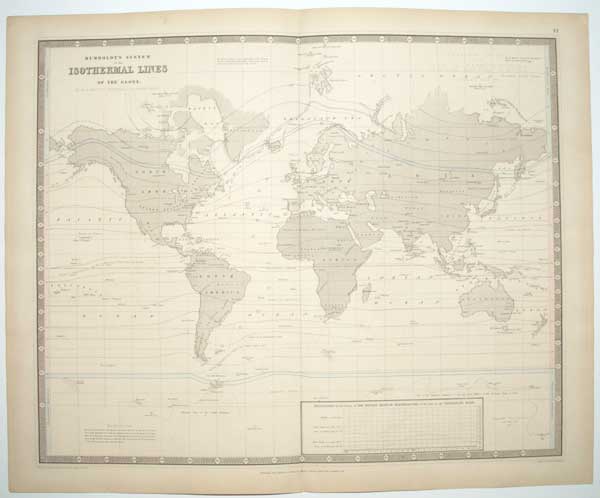
Humboldt's System of Isothermal Lines of the Globe. By Dr H Berghuas, Professor of Geography Berlin.
Drawn in the Engravers School for Geography, Potsdam, Dec.r 1842. Engraved by W. & A.K. Johnston.
Edinburgh; John Johnston and W. and W. & A.K. Johnson; Glasgow; Robert Weir Lumsden & Son [n.d., c.1844].
Engraved map with some original hand colour. Sheet 540 x 670mm (21 x 26½"). Some ink offset.
A map of the world on Mercator's Projection, with isothermal lines linking areas of equal temperature. Of interest are the markings for the furthest points north and south reached by explorers, including Parry and Scoresby in the Arctic and Cook, Weddell, D'Urville and Ross in the Antarctic.
[Ref: 57124] £130.00

Middlesex Hertforshire, Bedfordshire and Buckinghamshire. Railways. 2.
[James Reynolds, London 1863]
Hand coloured engraving, sheet 240 x 185mm (9½ x 7¼"). Folded as issued, time staining along taped fold.
From 'Reynolds's Geological Atlas of Great Britain'. A map of the railways showing ones under constuction and stations.
[Ref: 56920] £40.00
![[Theoria Lunae.]](img-thumbnail/jpegs/56971.jpg)
[Theoria Lunae.]
[Amsterdam: Jan Jansson, 1660 or 1661.]
Hand coloured engraving, 140 x 135mm (5½ x 5¼"), set in 4pp. folio letterpress. Some minor creasing to text.
Four pages from Andreas Cellarius' important celestial atlas, 'Harmonia Macrocosmica', the only celestial atlas published in the Netherlands before the 19th century. The engraving on the last page illustrates the orbit of the moon; measured against the zodiac.
[Ref: 56971] £320.00
Norfolk. Railways. 21.
[James Reynolds, London 1863]
Hand coloured engraving, sheet 185 x 240mm ( 7¼ x 9½"). Folded as issued, time staining along fold.
From 'Reynolds's Geological Atlas of Great Britain'. A map of the railways showing ones under constuction and stations.
[Ref: 56921] £40.00
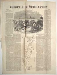
North Road Viaduct, Durham. Supplement to the Durham Chronicle.
J.W.B. del. E. Landells sc.
Duham, Friday 2, 1857.
Rare letterpress newspaper with two wood engravings. Sheet 655 x 490mm (25¾ x 19¼"). Folded, album sheet pasted to one quarter.
A newspaper account of the opening of the North Road Viaduct on the North-Eastern Railway in 1857. The wood engravings are a view of the viaduct with a locomotive in transit, with Durham Cathedral behind. It is now Grade II* listed.
[Ref: 56772] £190.00
(£228.00 incl.VAT)
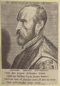
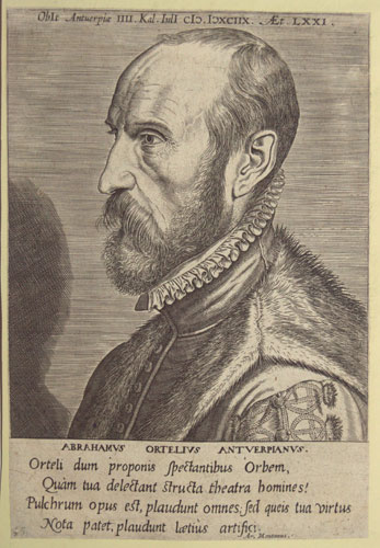
Abrahamvs Ortelivs Antverpianvs. Orteli dum proponis Spectantibus Orbem, Quam tua delectant structa theatra bomines! Pulchrum opus est, plaudunt omnes; fed queis tua virtus Nota patet, plaudunt laetis artifici. Ar. Montannus.
[n.d., c. 1572]
Engraving, sheet 220 x 130mm (8¾ x 5¼"). Trimmed and glued to backing sheet.
Portrait of Abraham Ortelius, bust in profile to the left, wearing a ruff and a fur-trimmed coat. With latin text by Benito Arias Montano. From the series irorum Doctorum de Disciplinis benemerentium Effigies XLIIII. Abraham Ortelius (also Ortels, Orthellius, Wortels; 1527 1598) was a Brabantian cartographer, geographer, and cosmographer, conventionally recognized as the creator of the first modern atlas, the Theatrum Orbis Terrarum (Theatre of the World). Ortelius is often considered one of the founders of the Netherlandish school of cartography and one of the most notable figures of the school in its golden age Not in Wellcome: 2188
[Ref: 57152] £160.00
(£192.00 incl.VAT)
![Ida Pfeiffer [facsimile signature].](img-thumbnail/jpegs/57088.jpg)
Ida Pfeiffer [facsimile signature].
A Dauthage 1855. Ged bei Jos. Stouss.
Very rare and scare lithograph, sheet 440 x 315mm (17½ x 12½"), very large margins. Trimmed and glued to backing sheet.
Portrait of world traveller Ida Pfeiffer with the Pyramids of Giza in the background. Ida Laura Pfeiffer (1797-1858), née Reyer, was an Austrian explorer, travel writer, and ethnographer. She was one of the first female travelers, whose bestselling journals were translated into seven languages. During her travels she collected plants, insects, mollusks, marine life, and mineral specimens. Many were sold to Museum für Naturkunde in Berlin and the British Museum.
[Ref: 57088] £360.00
![[Franz Ludwig Pfyffer von Wyher] Louis Pfyffer Seigneur de Wyher Lieutenant-General des Armées du Roi de sa Majesté Très-Chret.ne,](img-thumbnail/jpegs/57010.jpg)
[Franz Ludwig Pfyffer von Wyher] Louis Pfyffer Seigneur de Wyher Lieutenant-General des Armées du Roi de sa Majesté Très-Chret.ne, Commandeur de l'Ordre Royal et Militaire de St Louis &c. Né à Lucerne en 1716.
Gravé en 1786.
A Basle chez Chrétien de Mechel Graveur.
Aquatint. Sheet 245 x 175mm (9¾ x 7"). Trimmed within plate, a little soiling.
Franz Ludwig Pfyffer von Wyher, an officer in the French king's Swiss Guard who made a three-dimensional map of the area around Lake Lucerne, completed in 1786 and now the oldest relief map in existance. He took 24 years to construct it, using available materials including plaster, charcoal, sand, beeswax, brick & pottery, in 136 separate sections for easy transportation. It has been on display in the Glacier Garden in Lucerne for over a century. His military career was also successful: he retired with the rank of lieutenant general in 1768.
[Ref: 57010] £140.00
(£168.00 incl.VAT)
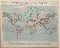
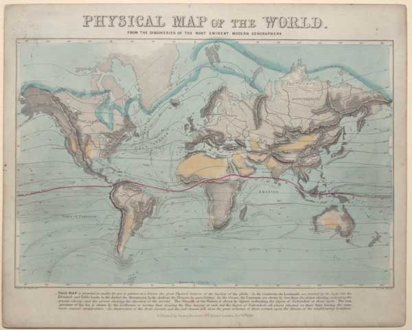
Physical Map Of The World. From The Discoveries Of The Most Eminent Modern Geographers.
Drawn & Engraved by John Emslie.
Published by James Reynolds 174 Strand London, Dec.r 10th 1849.
Hand coloured engraving, sheet 230 x 285mm (9 x 11¼"). Small ink splatter and abrasion top left corner. Ink stamp on the back 'St Thomas's Schools Mount Vernon.'
Map with explanatory text from Reynolds series 'Introduction to Natural Philosophy', a companion to Reynolds's series of Popular diagrams of natural philosophy comprising of two hundred and fifty illustrations. Shows the distribution of mountain ranges, deserts, the seasonal range of the Earth's icecaps and global ocean currents are shown along with air and sea temperatures around the world.
[Ref: 56832] £180.00
![[Major James Rennell F.R.S.]](img-thumbnail/jpegs/57015.jpg)
[Major James Rennell F.R.S.]
[Drawn by Scott. Engraved by A. Cardon.]
[London. Published as the Act directs, February 1799.]
Stipple, proof before letters. Sheet 205 x 115mm (8 x 6¼"). Trimmed to plate.
Major James Rennell (1742-1830), regarded as the Father of both Indian Cartography (for his survey of Bengal for the East India Company) and Oceanography (for his study of ocean currents). He compiled a map for the account of Mungo Park's first expedition to the Niger River that started the myth of the 'Mountains of Kong'.
[Ref: 57015] £160.00
(£192.00 incl.VAT)
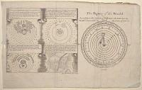
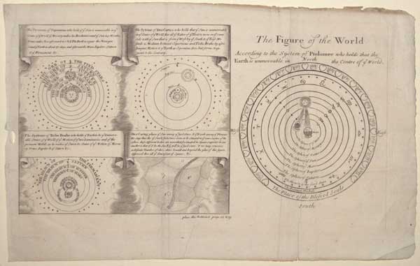
The Figure of the World According to the System of Ptolomee who holds that the Earth is unmoveable in the centre of ye World.
[after Philip Cluver.]
[n.d., c.1700.]
Engraving. 180 x 320mm (7 x 12½"). Binding folds, creases, edges ragged.
A plate comparing maps of the solar system according to Ptolomy, Copericus, Descartes and Brahe. From an English edition of Cluver's 'Introductio in universam geographiam...'.
[Ref: 56865] £160.00
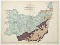
Suffolk. Railways. 27.
[James Reynolds, London 1863]
Hand coloured engraving, sheet 185 x 240mm ( 7¼ x 9½"). Folded as issued, time staining along fold.
From 'Reynolds's Geological Atlas of Great Britain'. A map of the railways showing ones under constuction and stations.
[Ref: 56922] £40.00
![[The Sun] Schema corporis Solaris, prouta P P Kirchero](img-thumbnail/jpegs/56859.jpg)
[The Sun] Schema corporis Solaris, prouta P P Kirchero et Scheinero Roma Anno 1635 observatum suit.
[after Athanasius Kircher & Christoph Scheiner.]
[n.d., c.1680.]
Engraving. Sheet 185 x 200mm. Repairs, time stained. Trimmed into plate at bottom, narrow margin at top.
A plan of the surface of the sun, based on the work of Jesuits Athanasius Kircher (1601-80) and Christoph Scheiner (c.1573-1650) as published in Kircher's 'Mundus Subterraneus', 1665. A key labels the solar axis, the solar equator, the northern and southern poles, sunspots and solar prominences (clouds of smoke).
[Ref: 56859] £160.00

Surrey and Sussex. Railways. 28.
[James Reynolds, London 1863]
Hand coloured engraving, sheet 185 x 240mm ( 7¼ x 9½"). Folded as issued, time staining along taped fold.
From 'Reynolds's Geological Atlas of Great Britain'. A map of the railways showing ones under constuction and stations.
[Ref: 56923] £40.00
![[A volvelle disk with a map of the Northern Hemisphere.]](img-thumbnail/jpegs/56798.jpg)
[A volvelle disk with a map of the Northern Hemisphere.]
[n.d., c.1820.]
Scarce engraving with original hand colour. Cut into a circle, 115mm (4½") diameter, pinhole in centre. Lacking backing sheet.
A volvelle disk, probably for calculating time difference. See reference 56881
[Ref: 56798] £320.00
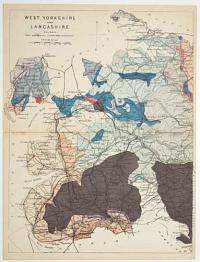
West Yorkshire and Lancashire. Railways. 18.
[James Reynolds, London 1863]
Hand coloured engraving, sheet 240 x 185mm (9½ x 7¼"). Folded as issued, time staining along fold.
From 'Reynolds's Geological Atlas of Great Britain'. A map of the railways showing ones under constuction and stations.
[Ref: 56918] £40.00
<<< Previous 1 Next >>>


![[Celestial Hemispheres] The First Part of the Northern Celestial Hemisphere. [&]](jpegs/56837.jpg)
![[Pair of Celestial Hemisheres] Northern Hemisphere. [&] Sothern Hemisphere.](jpegs/57036.jpg)

![[Untitled map of the path of the 1764 Solar Eclipse]](jpegs/56817.jpg)


![[Theoria Lunae.]](jpegs/56971.jpg)


![Ida Pfeiffer [facsimile signature].](jpegs/57088.jpg)
![[Franz Ludwig Pfyffer von Wyher] Louis Pfyffer Seigneur de Wyher Lieutenant-General des Armées du Roi de sa Majesté Très-Chret.ne,](jpegs/57010.jpg)
![[Major James Rennell F.R.S.]](jpegs/57015.jpg)

![[The Sun] Schema corporis Solaris, prouta P P Kirchero](jpegs/56859.jpg)

![[A volvelle disk with a map of the Northern Hemisphere.]](jpegs/56798.jpg)
