Results 1-12 of 12
<<< Previous 1 Next >>>

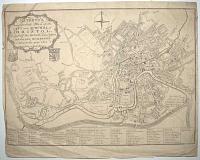
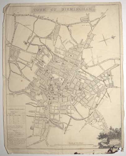
Town of Birmingham.
John Kempson, Surveyor & Land Agent, Birmingham.
[Birmingham, c.1827.]
Engraved map. 420 x 300mm (16½ x 11¾"), watermarked 'J Whatman 1827'. Ink stain causing paper loss lower right, splits in folds.
A town plan of Birmingham with a table of Hackney-Coach Fares.
[Ref: 56097] £230.00

Map of the Island of Elba. Porto Ferrajo.
Davies sculp.t.
Published by R. Bowyer, Pall Mall, 1825.
Coloured aquatint with stipple and line engraving; J. Whatman 1811 watermark. 410 x 285mm (16 x 11¼"). Very large margins on 3 sides.
An engraved map of Elba, an aquatint view of Porto Ferrajo, and an untitled stipple portrait of Napoleon Bonaparte, with two examples of his signatures. Published in Robert Bowyer's 'Triumphs in Europe, in the Campaigns of the Years 1812, 1813, 1814 commemorated by a Series of Twelve Views...', which celebrated (prematurely) the end of the Napoleonic Wars. This work was republished the following year as 'An Illustrated Record of Important Events in the Annals of Europe', and again with an sister publication 'The Campaign of Waterloo' from 1816.
[Ref: 55885] £180.00
Mathews's New & Correct Plan of the City and Suburbs of Bristol. including the Hotwells and Clifton and the new Buildings down to the year 1815 taken from actual Survey.
[c.1815.]
Engraved map, on verso in ink "Rich Champney". 330 x 460mm (13 x 18"). Tears taped, creasing.
A map of Bristol with a 54-point key, originally published in 'The New History, Survey and Description of the City and Suburbs of Bristol' in 1794. This example has the date changed and the arms of the city and merchants of Bristol added.
[Ref: 56095] £260.00
Plan of the Citys Intended Improvements at Snow Hill.
R. Metcalf sculp. 127 Bunhill Row.
Surveyors Office Guildhall [n.d., c.1802.]
Engraved map. 280 x 665mm (11 x 26¼"). Trimmed to plate, small hole and tear.
A plan showing the widening and continuation of the road at Snow Hill in the City of London, orientated with north at the bottom of the map. Houses to be purchased for demolition are numbered; and a proposal that 'a grand avenue [to] be made from Blackfryars Bridge to Islington' is mentioned.
[Ref: 56101] £230.00
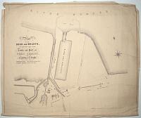
Plan of the Docks and Wharfs, Now Constructing at the Town and Port of Great Grimsby, in the County of Lincoln.
Engineer in Chief, James Meadows Rendel Esq.r. Resident Engineer, Adam Smith Esq.r.
[n.d., c.1850.]
Lithographic map. Sheet 380 x 450mm (15 x 17¾"). Tears, creasing and surface soiling.
Plan of the construction of Royal Dock (1849-52), under the supervision of James Meadows Rendel FRS (1799-1856).
[Ref: 56102] £60.00

Plan of the Town of Leeds. with the Recent Improvements. Surveyed in 1821 by Cha.s Fowler, Leeds. Engraved for the Yorkshire Directory.
Nelle & Son, 352 Strand.
Published by Edw.d Baines Leeds 1821.
Engraved map, 1820 watermark. 250 x 350mm (9¾ x 13¾"). Splits in binding folds taped.
Plan of Leeds with a 54-point key and an inset ''S.E. View of the Philosophical & Literary Society's Hall''.
[Ref: 56094] £80.00
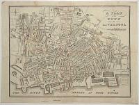
A Plan of the Town of Liverpool.
O'Connor Sculp.t 20 Rainsfords Gard.n.
[n.d., c.1800.]
Engraved map, 18th century watermark. On verso in ink Rich. Champney; 225 x 280mm (8¾ x 11"). Trimmed to plate top and bottom.
A detailed plan showing the docks.
[Ref: 56078] £160.00
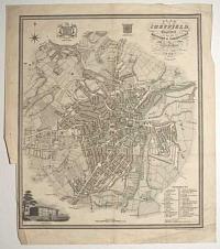
Plan of Sheffield, Engraved for the History & Directory of Yorkshire.
Alfred Smith Land Surveyor, Little Preston, near Leeds.
Published by Edward Baines, Leeds, 1822.
Engraved map. Printed area 310 x 260mm (12¼ x 10¼"), watermarked 1822. Trimmed close to printed border lower left by binder, creases and spotting.
Detailed plan of Sheffield, with a vignette view of the General Infirmary.
[Ref: 56098] £160.00
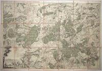
Réduction de la carte topographique des environs de St Hubert et de Rambouillet [Levée par ordre du roi, par les ingénieurs géographes des camps et marches des armées de sa majesté sous la direction du Sr Berthier, en 1764] pour servir aux chasse de sa Majesté [ink mss.].
Gravé par Guill. De-la-Haye.
[Paris, c.1764.]
Scarce engraved map with original hand colour, two sheets conjoined, dissected and laid on linen, total 560 x 825mm (22 x 32½"). Bookplate ''Ex Libris M.A. Principis Burghesii'' & ink mss title label ''Carte des Chasses de L'Empereur à Rambouilles'' pasted on linen. Original title half scratched out, label with old ink mss. pasted over. Ink stamp of the 'Depot general de la Guerre' in sky of vignette.
Map of the environs of Château de Rambouillet, one of Napoleon's official residences, orientated with north to the bottom right, with a vignette view of Louis XV's hunting lodge, the Château de Saint-Hubert. Scarce with French Royalty connections. Drawn by army engineers under the direction of Jean-Baptiste Berthier and engraved by Guillaume-Nicolas Delahaye, the map was originally published in 1764. This example seems to have been customised c.1810 for Camillo Filippo Ludovico Borghese, husband of Napoleon Bonaparte's sister Pauline, a 'Prince of the French Empire'. Half of the original title has been scratched out and replaced with hand written note 'for the use of his Majesty's hunt'. When Napoleon became emperor in 1804 Rambouillet was one of the residences put at his disposal, using the extensive lands for hunting, for which this map was adapted. (Saint-Hubert was unfinished on the death of Louis XV and had been abandoned) The last time Napoleon stayed at Rambouillet was a week after his second abdication in June 1815, leaving to go into exile on St Helena. At that time Borghese left Pauline and went to Florence.
[Ref: 56130] £650.00

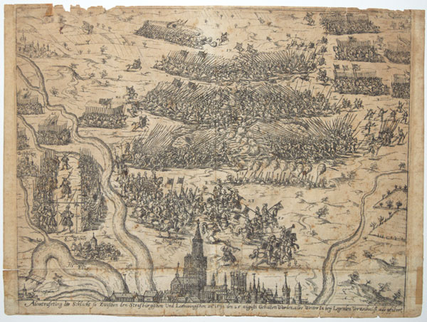
Abcontrasetung der Schacht so Zwischen den Strasbügischen Und Leharingischen an.º 1592 den 25 aügüsti Gerhalten Worden, alles Weiter In Beÿ Legenden Verzeihnüss, aüs gesühret.
[n.d., c.1600.
Scarce copper engraving. Sheet 210 x 285mm (8¼ x 11¼"). Damaged. Edge chipped, a short tear and a few old repairs and losses.
A map-view of a battle between the armies of Strasbourg and Lorraine, 25th August 1592, with the topography displayed as a map, but the battle graphically. A large profile of Strasbourg has the Cathedral shown prominently. This battle was fought during the religious wars that swept Germany (Strasboug had become Protestant in 1532); after this battle it was decided that the Cathedral should be shared between Protestants and Catholics, with a Bishop for each denomination.
[Ref: 56174] £260.00
(£312.00 incl.VAT)
![Whitsun Holidays. Excursion Trains at Half Fares to all stations of the South Eastern Railway...Saturday Excursion Trains. Half Fares...Boulogne & Amiens Railway. Excursion Trains for the Summer Season...[On verso:] The Continental Route. For Times of](img-thumbnail/jpegs/56176.jpg)
Whitsun Holidays. Excursion Trains at Half Fares to all stations of the South Eastern Railway...Saturday Excursion Trains. Half Fares...Boulogne & Amiens Railway. Excursion Trains for the Summer Season...[On verso:] The Continental Route. For Times of Sailing and other Particulars,-see pages 44 & 45. Contents. Through Trains (Down)...Table of Cab Fares.57. Excursion Trains. 59. [Map inside.] Paris, Brussels, Cologne, Frankfort, Bale, Berlin, Hamburgh, Leipsic, Vienna, and Warsaw.
[n.d. c. 1880.]
Letterpress and engraving. Small booklet of four sides; two sides of letterpress, interior sides of European train map. 128 x 164mm. 5 x 6½".
A booklet for the South Eastern Railway's excursions discounts and holiday plans, with a map of Europe inside showing the train routes available. The South Eastern Railway was established in 1836 and stayed in business until 1922. It was initially formed to construct a route from London to Dover, and then later opening lines to Tunbridge Wells, Hastings, Canterbury and other places in Kent. In 1844 the SER organised the first of seven rail and ferry excursions from London to Boulogne; and in 1854 the SER took over the South Eastern & Continental Steam Packet Company. In1866 when the SER was under the chairmanship of Sir Edward Watkin, who was also chairman of the Manchester, Sheffield and Lincolnshire Railway and the Metropolitan Railways, as well as being a director of the Chemin de Fer du Nord in France; he saw the SER as one link from the industrial north of England to the Continent and thus proposed the idea of the Channel Tunnel. The plans were ultimately blocked by the War Office.
[Ref: 56176] £130.00
view all images for this item

York. Engraved for the Yorkshire Directory.
Alfred Smith Land Surveyor, Little Preston, near Leeds. Neele & Son sculp. 352 Strand.
Published by Edward Baines, Leeds, 1822.
Engraved map. Printed area 335 x 290mm (13¼ x 11½"). Splits in folds with loss, laid on backing paper. Bit messy.
Detailed plan of York, with a vignette view of the New Ouse Bridge, designed by Peter Atkinson the younger, completed in 1821.
[Ref: 56100] £190.00
<<< Previous 1 Next >>>


![Whitsun Holidays. Excursion Trains at Half Fares to all stations of the South Eastern Railway...Saturday Excursion Trains. Half Fares...Boulogne & Amiens Railway. Excursion Trains for the Summer Season...[On verso:] The Continental Route. For Times of](jpegs/56176.jpg)
