Results 1-9 of 9
<<< Previous 1 Next >>>

A New Map of China Drawn from Surveys made by order of the Emperor. Engraved for Millar's New Complete & Universal System of Geography.
Engraved by T. Kitchin Hydrographer to his Majesty.
[London, c.1785.]
Engraved map. 350 x 385mm (13¾ x 15¼"), with very large margins. Original folds, some slight staining.
A map of China and Korea, with a decorative title cartouche featuring a pagoda and Chinese merchants.
[Ref: 55317] £200.00
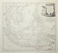
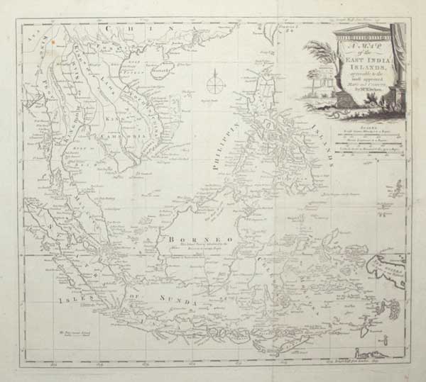
A Map of the East India Islands, agreeable to the most approved Maps and Charts, by Mr. Kitchin.
[engraved by Thomas Kitchin.]
[London, c.1785.]
Engraved map. 345 x 385mm (13½ x 15¼"), with very large margins. Original folds, some slight staining, some areas weakly inked.
A map of the East Indies, with the Malay Peninsula, Indochina, Indonesia and the Philippines. New Guinea has yet to be mapped properly. Originally published in 'Millar's New Complete & Universal System of Geography'.
[Ref: 55316] £250.00

Ireland.
London J. Fairburn 110, Minories [n.d., c.1800.]
Rare etching with original hand colour. Sheet 195 x 145mm (7¾ x 5¾"). Trimmed within printed border.
A pair of young lovers representing Ireland, with a harp top left. See: Ref 55333
[Ref: 55332] £130.00
(£156.00 incl.VAT)
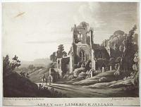
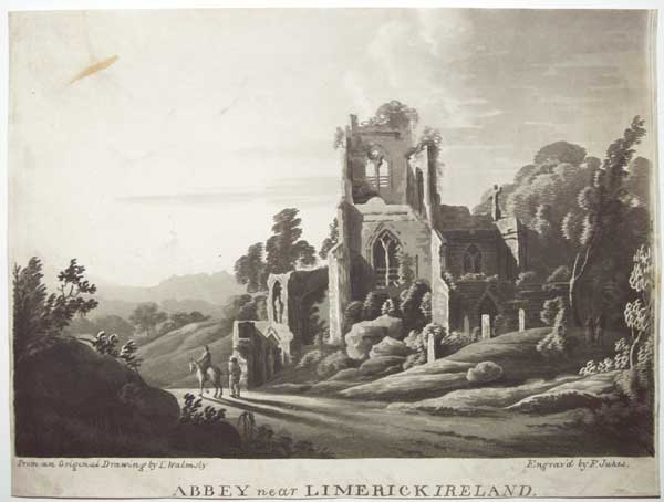
Abbey near Limerick Ireland.
From an Original Drawing by T Walmsly. Engrav'd by F. Jukes.
[n.d., c.1800.]
Rare aquatint. Sheet 220 x 295mm (8¾ x 11½"). Trimmed into image at top, within plate at bottom, and close to plate at sides. Some staining.
A ruined church by a country road.
[Ref: 55324] £180.00
(£216.00 incl.VAT)
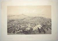
Marseille. Vue prise au dessus de la Gare du Chemin de Fer. Voyage Aérien en France.
Dessiné par Guesdon. Lith. par A. Cuvillier.
Paris, publié par A. Hauser, boul. des Italiens 11. Imp. Lemercier à Paris.
Tinted lithograph. Sheet 395 x 560mm (15½ x 22"), with very large margins.
An elevated view of Marseilles from above the railway station.
[Ref: 55296] £260.00
(£312.00 incl.VAT)
![[Pacific Ocean] A New and Accurate Chart of the Discoveries of Cap.n Cook, and other later Circumnavigators,](img-thumbnail/jpegs/55315.jpg)
[Pacific Ocean] A New and Accurate Chart of the Discoveries of Cap.n Cook, and other later Circumnavigators, exhibiting Norfolk Island, and Port Jackson where the new Settlement is formed, including The Whole Coast of New South Wales; also the New Discoveries on the Coast of North America, shewing Nootka Sound, Comprising likewise the Pelew and other new Discovered Islands situated in the Pacific Ocean.
Engrav'd by J. Lodge Jun.r.
Engraved map. 440 x 345mm (17¼ x 13½"), with very large margins. Tear top centre entering plate, repaired, creasing.
A map of the Pacific Ocean, showing the discoveries of all three of James Cook's voyages, including New South Wales, New Zealand, Hawaii and the Bering Strait. The title references the founding of the colony of Port Jackson in 1788 but the findings of George Vancouver in the American North West (1791-95) and George Bass and Matthew Flinders (1798-9), including the Bass Strait separating Tasman from the mainland, are lacking.
[Ref: 55315] £150.00
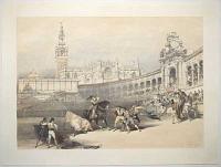
Bull Fight, Seville.
[Lithographed by Thomas Shotter Boys after David Roberts.]
[London Published Nov.r 1st 1836 by Hodgson & Graves, 6, Pall Mall.]
Coloured tinted lithograph. Image 360 x 475mm (14¼ x 18¾"), with large margins.
A view of Plaza de toros de la Real Maestranza de Caballería de Sevilla, with a bullfight in progress, with a picador in action. It was published in David Roberts's 'Picturesque Sketches in Spain', his first publication. Although the image is credited to Boys, it is known that Roberts worked on every stone. The success of this work enabled Roberts to finance his important excursion to Egypt and the Holy Land. Abbey Travel 152.
[Ref: 55292] £280.00
(£336.00 incl.VAT)

Atlas to the Modern State of Spain by J. Fr. Bourgoin[g,] Formerly Minister Plentipotentiary from France [to the] Court of Madrid.
London: John Stockdale, Piccadilly. 1808.
4to, original wrappers; printed title, pp, ii (contents), folding engraved map and 25 numbered plates (of 28). Covers worn, lacking title label on front cover; title page missing right hand corner, edges creased and worn.
The plate volume of an English edition of the description of Spain written by Jean-François, baron de Bourgoing (1748-1811), a diplomat who was secretary to the French legation to Madrid, 1777-86.
[Ref: 55313] £280.00
(£336.00 incl.VAT)
view all images for this item
![[Tétouan] View of Tetuan on the Coast of Barbary. Pirate chased by a French Frigate.](img-thumbnail/jpegs/55330.jpg)
[Tétouan] View of Tetuan on the Coast of Barbary. Pirate chased by a French Frigate.
Drawn by Baugean & G. Webster. Engravd by J. Dower.
Published by J. Dower & G. Webster, 6, Cumming Place, Pentonville, Jan.y 1st, 1821.
Rare aquatint, printed in blue and black, with touches of hand colour. 240 x 325mm (9½ x 12¾"), with large margins.
A night scene view of Tétouan, a port on the Mediterranean coast of Morocco, an infamous pirate base. In 1829, only two years before this print was published, the Austrian Empire had bombarded the city in reprisal for piratical attacks. Very atmospheric.
[Ref: 55330] £320.00
<<< Previous 1 Next >>>


![[Pacific Ocean] A New and Accurate Chart of the Discoveries of Cap.n Cook, and other later Circumnavigators,](jpegs/55315.jpg)

![[Tétouan] View of Tetuan on the Coast of Barbary. Pirate chased by a French Frigate.](jpegs/55330.jpg)