Results 1-11 of 11
<<< Previous 1 Next >>>

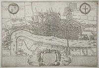
Boppart.
[Engraved by Frans Hogenberg.]
[Cologne, c.1588.]
Copper engraved map. Printed area 140 x 430mm, 5½ x 17". Trimmed into plate at top, false margin added.
Early town plan of Boppard in Germany, on the Rhinewith the Hunsrück Foothills in the background, published in Braun & Hogenberg's 'Civitatis Orbis' Terrarum', an atlas of over 500 city maps published in six parts between 1572 and 1617. On the reverse is a short Latin description of the city written by George Braun.
[Ref: 34395] £240.00
![[Brielle] Brilium, Holandiae opp. ob Intestinum Batavicum Bellum,Quod Anno Partae Salutis, M.D.LXXII. Callend Aplis, Hic Initium Sumpsit, Famosum.](img-thumbnail/jpegs/61104.jpg)
[Brielle] Brilium, Holandiae opp. ob Intestinum Batavicum Bellum,Quod Anno Partae Salutis, M.D.LXXII. Callend Aplis, Hic Initium Sumpsit, Famosum.
[Engraved by Frans Hogenberg.]
[Cologne, c.1575.]
Engraved map. 350 x 490mm (13¾ x 19¼"). Text page on reverse laid onto album paper, split in centre fold in bottom margin.
An early town plan of Brielle (Del Briel) in the Netherlands, orientated with north to the bottom of the map, published in the 'Civitates Orbis Terrarum', the first systematic atlas of townplans. The title celebrates the capture of the port on 1 April 1572 by a fleet of Dutch nobles rebelling against Spanish rule in the Netherlands. It proved to be a turning point in fortunes of the Low Countries in the Eighty Years' War.
[Ref: 61104] £160.00
![[Porec] Parens, sive Parentium vulgo, Parenzo Histrie Opp:](img-thumbnail/jpegs/55522.jpg)
[Porec] Parens, sive Parentium vulgo, Parenzo Histrie Opp:
[Engraved by Frans Hogenberg.]
[Amsterdam, Johannes Jansson, 1657.]
Engraving. Printed area 170 x 250mm (6¾ x 9¾"). Trimmed to printed border on two sides.
A prospect of Porec, Croatia, from the sea. Originally published in the Braun & Hogenberg 'Civitates Orbis Terrarum' atlas of townplans in 1575, this example comes from Jansson's Townbooks, which utlilised many of the Hogenberg plates.
[Ref: 55522] £160.00
(£192.00 incl.VAT)
![[Sibenik] Sibinium, Ptolemeo Sicum vulgo Sibenicho, Dalmatie opp:](img-thumbnail/jpegs/55519.jpg)
[Sibenik] Sibinium, Ptolemeo Sicum vulgo Sibenicho, Dalmatie opp:
[Engraved by Frans Hogenberg.]
[Amsterdam, Johannes Jansson, 1657.]
Engraving. Printed area 135 x 175mm (5¼ x 7"). Trimmed to printed border on two sides.
A prospect of Sibenik, Croatia, with St. Nicholas Fortress in the foreground. Originally published in the Braun & Hogenberg 'Civitates Orbis Terrarum' atlas of townplans in 1575, this example comes from Jansson's Townbooks, which utlilised many of the Hogenberg plates.
[Ref: 55519] £130.00
(£156.00 incl.VAT)

Elisabeth Dei Gratia Angliae / Franciae / Hynerniae et Virhi: Regi:. Soubs Philippe 2 gouvernant Parme & les Estats.
[Franz Hogenburg.]
[Amsterdam, 1616.]
Engraving. Platemark: 135 x 120mm (5¼ x 4¾"). Small tear to upper edge of sheet.
A portrait of Elizabeth I (1533 - 1603), Queen of England and Ireland from 1558 until her death. Sometimes called The Virgin Queen, or Gloriana, the childless Elizabeth was the fifth and last monarch of the Tudor dynasty. Text on reverse in French relating to the Dutch revolt against the rule of Philip II, where Robert Dudley, a close friend of Elizabeth I and champion of the international Protestant cause, led the English campaign in support of the Dutch Revolt from 1585-1587. An illustration to 'Les Guerres de Nassau, descrites par [...]', by Franz Hogenberg published in Amsterdam by Michel Colin, 1616.
[Ref: 39013] £230.00
(£276.00 incl.VAT)
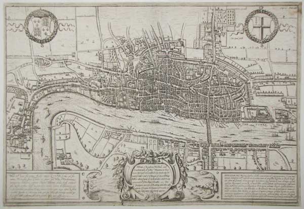
A Plan of London Westm.r and Southwark w.th ye Riv.r Thames, as they were Surveyd and publish't by Authority toward ye latter end of ye Raign of Queen Elizabeth; or about ye year of our Lord 1600. which being compared w.th ye New Map of London ~ The prodigious increase of Building and other alterations of ye names & Situation of Street &c. in this last centry will plainly apperar.
[engraved by Frans Hogenberg.]
[London: Edward Hatton, 1708.]
Engraved map. Sheet 330 x 480mm (13 x 19"). Trimmed close to printed border, laid on card.
The last state of the famed Braun & Hogenberg map of London, originally published in 1572, but showing London before the destruction of the spire of the Norman St Paul's Cathedral in 1561 (during the reign of Mary I). After passing through the hands of publisher Jan Jannson in Amsterdam (who removed the original title and engraved a new cartouche over the original costumes), the plate was bought by a London publisher and used in Hatton's ''A New View of London; or, an Ample Account of that City'', with an English title replacing the Latin. The original issue is the earliest printed map of London to survive. Howgego: 2, state 4.
[Ref: 61721] £1,800.00
![[The Departure of Matthias I from the Netherlands.]](img-thumbnail/jpegs/62292.jpg)
[The Departure of Matthias I from the Netherlands.] Dess Durchleuchttichsten Ertzhertzogen Mattheis Q. von den Niderlanden außzug.
[engraved by Frans Hogenberg]
[Cologne, n.d., c.1581.]
Engraving, 16th century watermark; 215 x 280mm (8½ x 7"). Top edge with tears entering plate taped.
Matthias (1557-1619) was invited to become Governor-General of the Spanish Netherlands in 1578 by the rebelling Dutch, against the will of his uncle, Spanish king Phillip II. He left the county when the Seventeen Provinces declared themselves a republic in 1581; he ruled as Holy Roman Emperor from 1612 to 1619, during this time the imperial capital moved from Prague to Vienna. From the 'Geschichtsblätter' (history sheets) published by Franz and Abraham Hogenberg between 1570 and 1610.
[Ref: 62292] £140.00
(£168.00 incl.VAT)

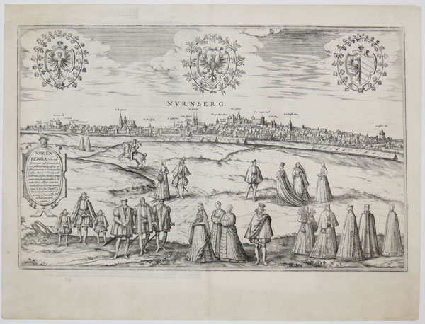
Nurnberg.
[Engraved by Frans Hogenberg.]
[Cologne, c.1575.]
Engraved map. 385 x 495mm (15¼ x 19½"). Repaired splits in top and bottom of centre fold.
A view of Nuremberg published in Braun & Hogenberg's 'Civitatis Orbis' Terrarum', an atlas of over 500 city maps published in six parts between 1572 and 1617. This place is unusual for the large number of illustrations of the wealthy residents of the city in the foreground. On the reverse is a short description of the city written by George Braun.
[Ref: 45357] £280.00
![[Oldenzaal under siege.]](img-thumbnail/jpegs/38640.jpg)
[Oldenzaal under siege.] Olden Zeel
Cum privilegio [after Franz Hogenberg, c.1605]
Etching, platemark 220 x 310mm (12¼ x 8½"). Fold through centre; late impression.
The city of Oldenzaal in the Netherlands under siege during the Eighty Years' War. In the hands of the Spanish since 1572, it was taken by Maurice of Orange in 1597 and then captured for Spain again by Ambrogio Spinola in 1605. Despite various differences, this print is probably derived from a representation of the 1605 conflict in the 'Geschichtsblätter' (history sheets) published by Franz and Abraham Hogenberg between 1570 and 1610.
[Ref: 38640] £50.00
(£60.00 incl.VAT)
![[The Siege of Paris 1590.]](img-thumbnail/jpegs/51172.jpg)
[The Siege of Paris 1590.] Warhaftige Description und Beschreibung der Stadt Paris, mit beiliggede Stetten, Schlosser und Dorffer. Descriptio de la Ville de Paris, avecq les Villes Citez et Villages Circonvoisins.
[Engraved by Frans Hogenberg.]
[Cologne, c.1590.]
Etching, 16th century watermark. 220 x 280mm (8¾ x 11"), with large margins. Old ink mss. in lower margin.
A C16th map of the environs of Paris, showing the city under siege by King Henry of Navarre (later Henry IV of France), with the armies of Alexander Farnese, Duke of Parma (here marked 'H[erzog] võ Parma], attempting to relieve the city. From Michaël Eytzinger's chronicle of the wars of Europe, a first state of the map, before the title was excised. Eytzinger is best known for his fantasy 'Leo Belgicus' map, depicting the Netherlands as a lion rampant.
[Ref: 51172] £400.00

Wurtzburg Herbipolis, comuniter Wirtzburg Orientalis Franciae Metropolis.
[Frans Hogenberg, c.1600.]
Engraving, sheet 265 x 245mm (10½ x 9¾"). Trimmed; vertical fold as normal.
Würzburg, in Franconia, part of the Bavaria region of Germany. The streets of the Old Town are still recognisable today. The Marienberg fortress can be seen in the distance, with St Kilian's cathedral by the river. Many of the city's landmarks are labelled. Trimmed from a larger sheet from Braun & Hogenberg's 'Civitates Orbis Terrarum', on which it was originally accompanied by views of Mainz and Sion.
[Ref: 42108] £140.00
(£168.00 incl.VAT)
<<< Previous 1 Next >>>

![[Brielle] Brilium, Holandiae opp. ob Intestinum Batavicum Bellum,Quod Anno Partae Salutis, M.D.LXXII. Callend Aplis, Hic Initium Sumpsit, Famosum.](jpegs/61104.jpg)
![[Porec] Parens, sive Parentium vulgo, Parenzo Histrie Opp:](jpegs/55522.jpg)
![[Sibenik] Sibinium, Ptolemeo Sicum vulgo Sibenicho, Dalmatie opp:](jpegs/55519.jpg)

![[The Departure of Matthias I from the Netherlands.]](jpegs/62292.jpg)
![[Oldenzaal under siege.]](jpegs/38640.jpg)
![[The Siege of Paris 1590.]](jpegs/51172.jpg)
