Results 1-16 of 16
<<< Previous 1 Next >>>

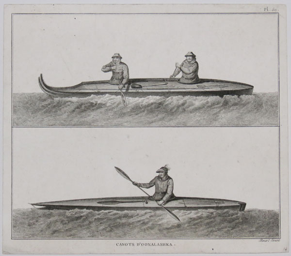
Canots D'Oonalashka.
Bénard direxit. [n.d. c.1785.]
Engraving. Collector's mark verso bottom right; 242 x 278mm (9½ x 11"). Trimmed.
Natives of Unalaska, Alaska in canoes, from a French edition of James Cook's Third Voyage. Captain James Cook, explorer, cartographer and hydrographer went to command several notable voyages, the first was from 1768-1771. He was led to his commission by the direction of British overseas exploration in 1766 as commander of HM Endeavour for the first of three Pacific voyages. Cook's journals were published upon his return, and he became something of a hero among the scientific community. Cook's 12 years sailing around the Pacific Ocean contributed much to European knowledge of the area.
[Ref: 31089] £90.00
(£108.00 incl.VAT)

Astronomie. 159. Suppl Pl 8.
Benard Direx.
[n.d. c.1780].
Copper engraving, 18th century watermark, 355 x 235mm (14 x 9¼"). Thread margin on right. Couple of brown spots, crease.
Most likely from the 1780's five-volume supplement to 'Encyclopédie, ou Dictionnaire raisonné des sciences, des arts et des métiers,' edited by Denis Diderot and Jean d'Alembert, with the aid of Quensay, Montesquieu, Voltaire, J. J. Rousseau, Turgot, and others.
[Ref: 60628] £65.00
(£78.00 incl.VAT)
![[26 Bound plates of Astronomy]](img-thumbnail/jpegs/59550.jpg)
[26 Bound plates of Astronomy] Astronomie.
Goussier Del. Benard Fecit.
[n.d. c.1750]
Bound engravings, plates 350 x 220mm (13¾ x 8¾"), with large margins. No cover.
Images of astronomical diagrams, instruments and astrology. Louis-Jacques Goussier (1722 - 1799) was a French illustrator and encyclopedist. Louis-Jacques Goussier is famous for his work on Diderot's encyclopedia. He was the first drawer to be hired on that project, in 1747 and he did himself more than 900 plates and directed the drawing of the others. Robert Bénard (1734 – 1777) was a French engraver. Specialized in the technique of engraving, Robert Bénard is mainly famous for having supplied a significant amount of plates (at least 1,800) to the Encyclopédie by Diderot & d'Alembert from 1751.
[Ref: 59550] £600.00
view all images for this item
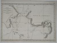
Carte de l'Entrée de Norton, et du Détroit de Bhering ou l'on voit le Cap le plus Oriental de L'Asie, et la Pointe la plus Occidentale de L'Amerique.
Benard direxit.
[Paris 1787.]
Engraving. 280 x 390mm (11 x 15¼"). Trimmed.
Chart of the Bering Strait and Norton Sound, Alaska, showing the two attempts of Captain Cook's ship to penetrate the Straits on his third & final voyage, 1778-79. After his discovery of Hawaii Cook sailed north along the west coast of America, looking for the North West Passage. Having passing through the Bering Strait only to be blocked by the Arctic ice, he returned to Hawaii and was murdered in 1779. Afterwards the expedition, under the command of Captain Clerke, made a final attempt on the Bering Strait. Engraved by Bénard for a French edition of the Official Account of Cook's Voyages.
[Ref: 13528] £65.00
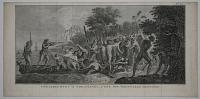
Débarquement a Erramanga, L'une des Nouvelles Hébrides.
Benard Direx [after William Hodges].
[Paris, Saillant et Nyon & Panckouke, c.1777.]
Engraving. 240 x 280mm, 9½ x 19". Tear in margin, original binding folds.
The landing at Eromanga, one of the New Hebrides or Vanutu, showing the Captain Cook's crew battling with native warriors in 1774. The original picture was painted by William Hodges (1744-97), the official artist on Cook's second circumnavigation. This example was published in a French edition of the Official Account of Cook's Second Voyage.
[Ref: 18799] £220.00
(£264.00 incl.VAT)
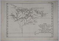
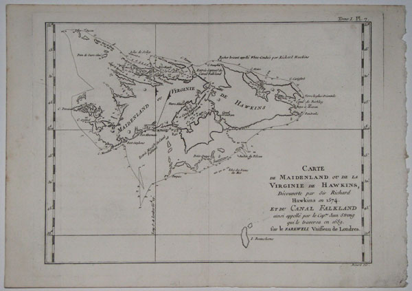
Carte de Maidenland ou de la Virginie de Hawkins, Découverte par Sir Richard Hawkins en 1574. Et du Canal Falkland ainsi appellé par le Cap.ne Jean Strong qui le traversa en 1689, sur la Farewell Vaisseau de Londrres.
Benard dir.
[Paris 1787.]
Engraving. 240 x 320mm, 9½ x 12½".
Map of the Falkland Islands after the map by John Strong, an English captain who traversed Falkland Sound in 1690. Sir Richard Hawkins (son of Sir John Hawkins of Spanish Armada fame) is credited with discovering the island in 1574, naming it Hawkins' Maidenland (after Elizabeth the Virgin Queen). However at that time he would have been aged twelve. In fact he visted the islands in 1594, preceded by Dutchman Sebald de Weert in 1600 and English explorer John Davis in 1592. Engraved by Bénard for a French edition of the Official Account of Cook's Voyages, which included accounts of other English explorers in the South Seas.
[Ref: 13537] £170.00

Vue des Habitations dfe L'Entrée de Nootka.
Benard direxit [after John Webber].
[Paris, 1785.]
Engraving. 245 x 375mm (9¾ x 14¾"). Trimmed close to the plate at the top. Folds as issued.
A view of the habitations of the natives of Nootka Sound. Low, broad buildings of slatted wood with flat roofs are constructed against and on top of dunes at the edge of the water, with frames for drying fish standing near them. Numerous figures are gathered on the shore in the foreground, mostly seated, receiving the Europeans with one in the shallows in the centre, bending over the contents of a laden canoe. Engraved by Robert Benard for the French edition of 'A Voyage to the Pacific Ocean' (1784), the official account of Captain Cook's Third and final voyage.
[Ref: 51226] £120.00
(£144.00 incl.VAT)

Vue de L'Interieur d'une Maison de L'Entrée de Nootka.
[after John Webber] Benard Direxit.
[Paris, 1785.]
Engraving. 270 x 400mm (10½ x 15¾"). Narrow margin at top. Repaired tear. Folds as issued.
An interior scene depicting a group of men and women, drying fish, baskets and chests, within a traditional communal house, with carved ornaments in the background. Engraved by Robert Benard after John Webber for the French edition of 'A Voyage to the Pacific Ocean' (1784), the official account of Captain Cook's Third and final voyage.
[Ref: 51225] £80.00
(£96.00 incl.VAT)
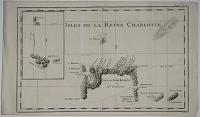
Isles de la Reine Charlotte.
Benard dir.
[Paris 1787.]
Engraving. 250 x 405mm, 9¾ x 16". Narrow bottom margin.
Chart of Nendö Island, largest of the Santa Cruz Islands, part of the Solomon Islands group, as mapped by Captain Cartaret in 1767, the first time the islands had been located since 1568. North of the island is a volcano, now called Nupani. Engraved by Bénard for a French edition of the Official Account of Cook's Voyages, which included accounts of other English explorers in the South Seas.
[Ref: 13532] £65.00
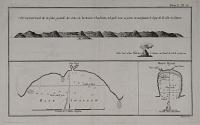
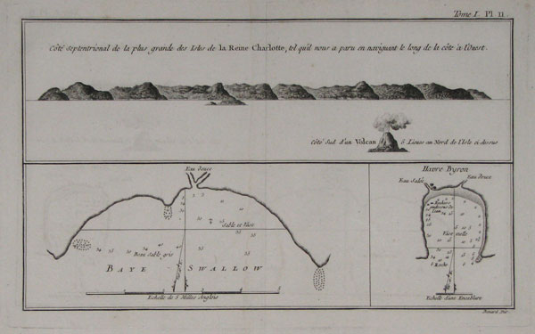
Côte Septentrionale de la plus grande des Isles de la Reine Charlotte tel qu'il nous a paru en navigant le long de la côte à l'Ouest.
Benard dir.
[Paris 1787.]
Engraving. 190 x 295mm, 7½ x 11¾".
A coastal profile and charts of two bays on Nendö Island, the largest of the Santa Cruz Islands, part of the Solomon Islands group, as mapped by Captain Cartaret in 1767, the first time the islands had been located since 1568. Swallow Bay was named after his ship; Byron Harbour was named after John Byron, under whom Cartaret had served. The volcano shown in profile is now called Nupani. Engraved by Bénard for a French edition of the Official Account of Cook's Voyages, which included accounts of other English explorers in the South Seas.
[Ref: 13533] £75.00
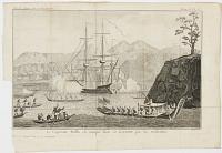
Le Capitaine Wallis est attaqué dans le Dauphin par les Otahiens.
Benard dir.
[Paris: c.1777.]
Fine engraving. 215 x 350mm (8½ x 13¾"). Trimmed into plate lower left by binder, folded as issued.
Samuel Wallis (1728-95) and his ship, HMS Dolphin under attack in Matavi bay of Tahiti, June 1767. Wallis was ill, so Lieutenant Tobias Furneaux went ashore and claimed the Island for Britain, calling it 'King George the Third's Island'. This scene was copied for the first French edition of Hawkesworth, 'Relation des voyages..' published 1774, but this example comes from a volume of Abbé Prevost's 'Histoire des Voyages', c.1777.
[Ref: 41913] £220.00
(£264.00 incl.VAT)

Vue de l'Isle d'Otahiti et de plusiers Pirogues.
Benard Fecit.
[Paris, Saillant et Nyon & Panckouke, c.1774.]
Engraving. 235360mm (9¼ x 14¼") very large margins Uncut.
A small Tahitian dugout boat, sketched by Sydney Parkinson, who had died before the expedition reached England; however, after a dispute over ownership of his work with Parkinson's brother, Hawkesworth removed every reference to Parkinson from the Official Account of Cook's first voyage. This scene was copied by Robert Benard for the first French edition, 'Relation des voyages..' published 1774.
[Ref: 51223] £160.00
(£192.00 incl.VAT)
![[Tahiti] Potatow, Chef de Tahiti.](img-thumbnail/jpegs/26846.jpg)
[Tahiti] Potatow, Chef de Tahiti. Pl.14.
Benard Direx.
[n.d. c.1778.]
Engraving, small margins. Plate 235 x 183mm. 9¼ x 7¼".
This print is from a French edition of the account of Cook's second voyage, 'Voyage dans l'hemisphere austral et autour du monde fait dans les vaisseaux du roi, l'Aventure et la Resolution', first published in Paris in 1778. The depiction originates from a drawing now in the State Library of New South Wales by William Hodges (1744 - 1797) which is better known from the engraving by Hall in the orignal English account of the second voyage, published by Strahan and Cadell in 1773, with the title 'A voyage towards the South Pole and round the world: performed in His Majesty's ships the Resolution and Adventure.'
[Ref: 26846] £140.00
(£168.00 incl.VAT)
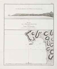
Vue du Côté Méridional de la Baye de L'Adventure/ Plan de la Baye de l'Adventure sur la Terre Van-Diemen.
Benard direxit.
[Paris 1787.]
Engraving. 270 x 230mm (10½ x 9").
A coastline profile and chart of Adventure Bay on the south coast of Tasmania. Captain Tobias Furneaux named the bay after his ship HMS Adventure, having stayed there for five days in 1773, having being separated from from Cook during his second circumnavigation. However these were sketched (possibly by William Bligh) during Cook's Third Voyage, 1776-1780. Engraved by Bénard for a French edition of the Official Account of Cook's Voyages.
[Ref: 13536] £75.00
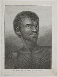
Un Homme de la Terre de Van-Diemen. Pl.6.
Bernard direxit.
[n.d., c.1793.]
Engraving. Plate: 240 x 185mm (9½ x 7¼''). Thread margins.
A plate from the French edition of 'Cook's Voyage to the Pacific' after John Webber's original drawings. A portrait of a man from Tasmania, known as Van Dieman's Land until the mid nineteenth century. John Webber (1751-93) travelled with Captain Cook on the Third Voyage (1776-80) as the Official Artist of the expedition, recording the explorer's death at the hand of Hawaiian natives.
[Ref: 51001] £130.00
(£156.00 incl.VAT)

Isle de Sir Charles Saunder ; Isle Ofnabrug ; Isle Boscawen ; Isle de l'Admiral Keppel ; Isle de Wallis.
Benard Dir.
[Paris 1787.]
Engraving. 200 x 260mm, 8 x 10½".
Five coastal profiles of islands in or around the Tonga Islands group. The islands are (in order of title) Maiao in the Windward Islands of the Society Islands; Mehetia in the Society Islands in the vicinity of Wallis Island; Niuatoputapu; Tafahi; Wallis Island in the Wallis and Futuna Island group. Engraved by Bénard for a French edition of the Official Account of Cook's Voyages, which included accounts of other English explorers in the South Seas.
[Ref: 13534] £65.00
(£78.00 incl.VAT)
<<< Previous 1 Next >>>

![[26 Bound plates of Astronomy]](jpegs/59550.jpg)






![[Tahiti] Potatow, Chef de Tahiti.](jpegs/26846.jpg)