Results 1-2 of 2
<<< Previous 1 Next >>>
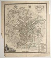
Plan of Sheffield, Engraved for the History & Directory of Yorkshire.
Alfred Smith Land Surveyor, Little Preston, near Leeds.
Published by Edward Baines, Leeds, 1822.
Engraved map. Printed area 310 x 260mm (12¼ x 10¼"), watermarked 1822. Trimmed close to printed border lower left by binder, creases and spotting.
Detailed plan of Sheffield, with a vignette view of the General Infirmary.
[Ref: 56098] £160.00

York. Engraved for the Yorkshire Directory.
Alfred Smith Land Surveyor, Little Preston, near Leeds. Neele & Son sculp. 352 Strand.
Published by Edward Baines, Leeds, 1822.
Engraved map. Printed area 335 x 290mm (13¼ x 11½"). Splits in folds with loss, laid on backing paper. Bit messy.
Detailed plan of York, with a vignette view of the New Ouse Bridge, designed by Peter Atkinson the younger, completed in 1821.
[Ref: 56100] £190.00
<<< Previous 1 Next >>>