Results 1-1 of 1
<<< Previous 1 Next >>>
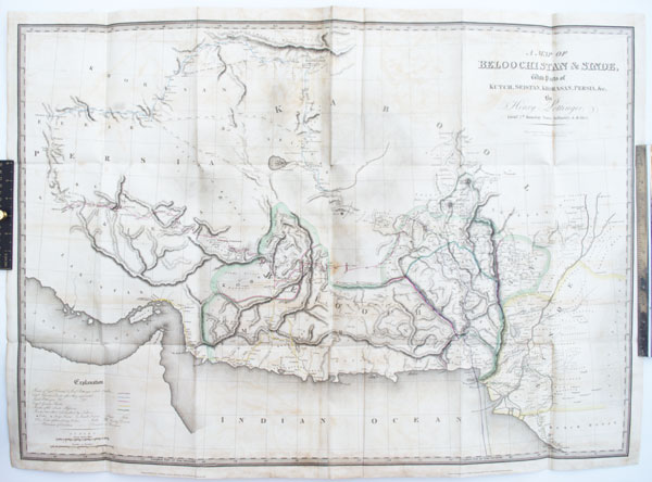
A Map of Beloochistan & Sinde, with Parts of Kutch, Seistan, Khorasan, Persia, &c. by Henry Pottinger, Lieut.t 7th Bombay Native Infantry, A.D. 1814.
Reduced from the Original Document and Engraved by Thomson & Hall, Bury Street, Bloomsbury.
London, Published Feb.y 27th 1816, by Longman, Hurst Rees, Orme & Brown, Paternoster Row.
Engraving with stipple, with original hand colour. Two sheets conjoined, total 665 x 930mm (26¼ x 36½"). Some offset, folded; cracks in folds.
A rare map of Balochistan, covering parts of Pakistan, Afghanistan and southern Persia, marking the routes of Henry Pottinger and Captain Charles Christie as they mapped the region for the East India Company, amid concerns that Napoleonic France could invade India. Disguised as Muslims, they travelled together to Nushki before separating and taking different routes to Isfahan in Iran. Later Pottinger was appointent envoy and plenipotentiary in China, as which he negotiated the Treaty of Nanking (1842), ending the First Opium War and ceding Hong Kong to Britain. The following year he became the first Governor of Hong Kong, then Governor of the Cape Colony (1847) and Governor of Madras (1848-54).
[Ref: 57970] £650.00
<<< Previous 1 Next >>>