Results 1-4 of 4
<<< Previous 1 Next >>>

A Geometrical Plan, & North West Elevation Of His Majesty's Dock-Yard, at Deptford with Part of the Town. &c. To the Right Honourable Henry Arthur Earl of Powis, Viscount Ludlow Baron Powis of Powis Castle Baron Herbert of Chirbury and Baron of Ludlow. This Plate is humbly inscribed by his Lordship's most dutiful and Obedient Servant. Tho: Milton
Tho.s Milton Surv:et delin.t. P.C. Canot Sculp.t.
Publish'd according to Act of Parliament July 30th 1753.
Engraving. Sheet 470 x 650mm (18½ x 25½"). Trimmed to printed border, some loss at edges, laid on album paper. Damaged.
A large and detailed plan of the naval docks at Deptford with a prospect, within an ornate border containing the title, dedication, key and vignettes of shipbuilding. One of an important set of six plans of the Royal Dockyards by Thomas Milton (1743-1827), a surveyor, draughtsman and engraver, a pupil of Woollett. He worked in Dublin and London and was governor of the Society of Engravers.
[Ref: 64131] £420.00
Le Port De Plymouth. Vue du coté de l'Ouest.
Peint par Thom. Milton. Suru et des. Grave par Suntach.
Réduit de la Collection des Prts d'Angleterrede'sines par Milton et graves par Suntach l'anne 1788.
Engraving. Sheet size: 200 x 235mm (8 x 9¼"). Cut inside plate. Glued to backing sheet. A few surface marks.
A view of the port of Plymouth, taken from the west, with numerous sailing vessels in the water, each named in a key below the image, as well as the builidings in the port in the distance. From the collection of prints of English ports, designed by Milton and engraved by Suntach.
[Ref: 38756] £130.00
(£156.00 incl.VAT)
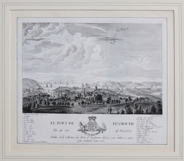
Le Port De Plymouth Vue du coté du Nord-Est.
Peint par Thom. Milton. Suru et des. Grave par Suntach.
Réduit de la Collection des Prts d'Angleterrede'sines par Milton et graves par Suntach l'anne 1788.
Engraving. Sheet size: 200 x 235mm (8 x 9¼"). Cut inside plate. Glued to backing sheet.
A view of the port of Plymouth, taken from the north-east, looking out to sea over the town itself, with numerous buildings including a church in the middle ground, and sailing vessels on the water beyond the port. The points of interest and ships are numbered, with a key below the image. From the collection of prints of English ports, designed by Milton and engraved by Suntach.
[Ref: 38757] £230.00
(£276.00 incl.VAT)
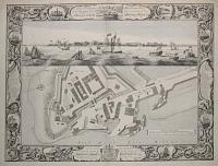
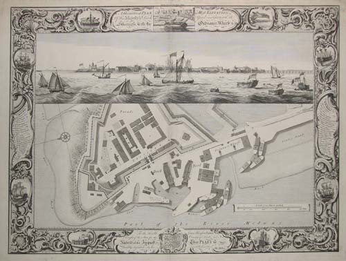
A Geometrical Plan, & West Elevation Of His Majesty's Dock-Yard, and Garrison at Sheerness, with the Ordanance , Warfe, &. C. To the Honourable Lewis Monson Watson Knight of the Shire for the County of Kent, and Auditor of the Imprest, This plate is humbly inscribed by his most Obedient Servt. Thos. Milton.
Thos. Milton Surv:etdelin: Shipping by T.Cleveley P.C.Canot Sculpt.
Publsih'd according to Act of Parliament Thos. Milton. 14 April 1755.
Engraving 495 x 660mm. Trimmed to plate, centre fold, minor nicks and scratches
Explanation and Key to plan and elevation left and right. Sheerness was the focus of an attack by the Dutch navy in June 1667, when 72 hostile ships during the Raid on the Medway compelled the little 'sandspit fort', to surrender and landed a force which for a short while occupied the town. Impressed by the civil behaviour of the Dutch marines - they paid for their dinner - the town reinvited the Dutch Marine Corps for the third centennial of the raid. Pepys at Gravesend remarked in his diary 'we do plainly at this time hear the guns play' and in fear departed to Brampton in Huntingdonshire. Sheerness was also the site of a Royal Dockyard which, although not as large as those at Chatham and Deptford was still of some importance in Tudor and Stuart England. During the Victorian age a warship was built which still exists - HMS Gannet (an 'Osprey' class Sloop) which was launched on 31 August 1878.
[Ref: 4258] £650.00
<<< Previous 1 Next >>>