Egypt, Called in the Language of the Country Missir; Drawn from D'Anville's Atlas.
Engraved for J. Harrison, No 115 Newgate Street. Oct.r 11th, 1788. Engraving. 490 x 370mm. Map of Egypt after the French cartographer d'Anville, showing the Nile south to Aswan.
[Ref: 3043] £130.00
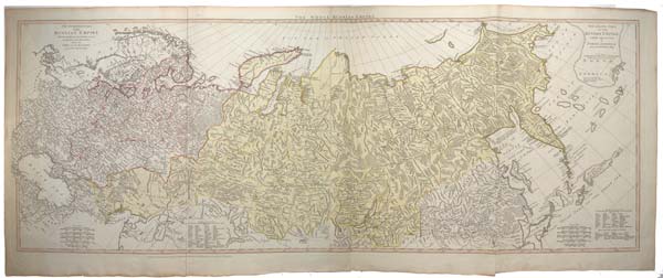
The Whole Russian Empire. The European Part of the Russian Empire With the Several Countries that are the Theatre of the Present War between the Turks and the Russians, from D'Anville's maps. [&] The Asiatic Part of the Russian Empire with the adjacent Coast of North America from D'Anville's Map.
London Printed for R. Sayer Map & Printseller No 53 Fleet Street. Published as the Act directs 2.d March 1772. Engraved map on two sheets conjoined, as issued, with original hand colour. 18th century watermark, Total 490 1280mm (19¼ x 50½"), with wide margins. Crack on binding fold taped. A two-sheet map of the Russian Empire, each with its own title, but with a joint title across the two sheets. It shows from Poland (which was partitioned by Russia, Prussian and Austria later in the year) and the Balkans east to Kamchatka and the Kuriles. What the map calls the 'adjacent coast of North America' is an amorphous peninsula stretching under the eastern limit of the Asian coastline. In the Pacific are many large islands, including Schouten's mythical 'Company's Land' and the confused Jesso/Hokkaido.
[Ref: 54166] £480.00
view all images for this item