Catalogue: Maps
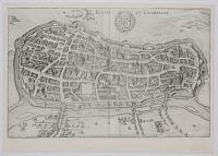
Reims en Campagne.
M.Merian fecit.
[Frankfurt, Merian, c.1650.]
Engraved map. Sheet 210 x 330m 8¼ x 13". Trimmed and laid on card.
Map-view of Rheims, north-east of Paris. Cathedral of Reims (Rheims), the most mythical one in France, where the coronation of the French kings took place.
[Ref: 23607] £70.00
![[The Arctic Circle on globe sheets.]](img-thumbnail/jpegs/10905.jpg)
[The Arctic Circle on globe sheets.]
[n.d., c.1790.]
Pair of coloured engravings, two semi-cicles making a diameter of 340mm, 13½".
Pair of sheets apparently designed to be pasted onto a globe. In Arctic America the Mackenzie River is marked (discovered 1789) but the discoveries of Captain Cook in Alaska from 1778 are not. In the East Novaya Zemlya still has its early shape.
[Ref: 10905] £260.00
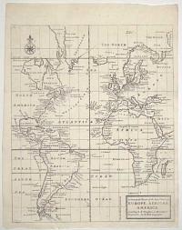
A General Chart of the Sea Coast of Europe, Africa & America. According to E. Wrights or Mercator's Projection.
By H. Moll Geographer.
[n.d., 1720.]
Engraved map. 345 x 285mm (13½ x 11¼"). Original binding folds.
A sea chart centred on the Atlantic Ocean, but also showing all of South America, Africa and the Black Sea. Of interest in the mythical Peypys Island off South America. From Josiah Burchett's 'A Complete History of the Most Remarkable Transactions at Sea, from the Earliest Account... to the Conclusion of the Last War with France''. Edward Wright (1561-1615), a mathmatician and surveyor, not only corrected Mercator's Projection but also published a guide explaining how to use charts using that projection, something that Gerhard Mercator had never done. His work gave British navigators a particular advantage over the competition.
[Ref: 61702] £250.00
![[Untitled map of Bath]](img-thumbnail/jpegs/59729.jpg)
[Untitled map of Bath]
London: G.W. Bacon & Co., Ltd., Norwich St. E.C.4.
[n.d., c.1920.]
Wood-engraved map. Sheet 670 x 830mm (26½ x 32¾"), folded into original cloth covers. Splits in folds, tape stains.
A map of Bath with advertisments for the wine merchants 'Sainsbury Bros.', famous tea and coffee merchants 'Gillards of Bath' and milliners William Rayner. We have dated the map from Bacon's address, which they used 1919-22.
[Ref: 59729] £60.00
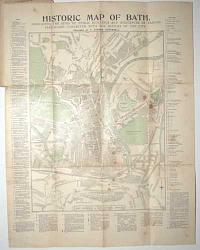
Historic Map of Bath. Indicating the Sites of Public Buildings and Residences of Famous Personages Connected with the History of the City.
Prepared by T. Sturgis Cotterell.
Printed and Published at the Bath Chronicle & Bath Pictorial Offices. Revised to 1898.
Wood engraved map, printed in colours. 570 x 450mm (22½ x 17¾"), folded into original printed boards, adverts on verso. Map with wax stains; covers taped at spine, damped stained.
A tourist's map of Bath, with extensive keys of important sights. Among the list of famous residents are the Henry Fielding, William Herschel, Beau Nash, Frederick Leighton, Thomas Gainsborough and, of course, Jane Austen.
[Ref: 59725] £75.00
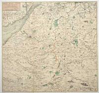
Map of 24 Miles Round the City of Bath, Most humbly dedicated to the Residents and Visitors by their obedient Servant C. Harcourt Masters.
[n.d., c.1812.]
Engraved map with original hand colour. Dissected and laid on linen, as issued, total 590 x 615mm (23¼ x 24¼"), folded into slipcase with old ink mss. title.
A detailed map of the environs of Bath, marking Glastonbury clockwise to Bristol, Newport, Cirencester, Cricklade and Salisbury. Library of Congress, Bath in Time.
[Ref: 59723] £360.00
![Auszug aus einer See-Charte die Andreas Bianco im I[ahr] 1436 zu Venedig verfertigte...](img-thumbnail/jpegs/53128.jpg)
Auszug aus einer See-Charte die Andreas Bianco im I[ahr] 1436 zu Venedig verfertigte... Auszug aus einer Charte die Fr. Picigano im I[ahr] 1367 zu Venedig verfertigte...
A.G. Ephem 1807. 10. stk.
Weimar, im Verlag des geograph. Instituts, 1807.
Engraved map. 180 x 230mm (7 x 9"). Folds as issued.
Two facsimiles of Venetian charts of the 15th & 16th centuries, showing the Atlantic before the known discovery of America, The presence of 'Y.a d'Antilla', a large island west of Madeira, is often used to argue that the Portuguese discovered America before Colombus.
[Ref: 53128] £140.00
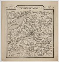
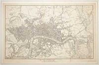
A Map of the Country Eleven Miles Round the City of Bristol.
Engraved for Chillcott's Guide to Bristol, Clifton, Hotwells and its Environs. By Permission from M.r Donne's Map of the Country 21 Miles round the City.
Sold in Bristol, Bath, &c. by all the principal Booksellers. [n.d., c.1805.]
Map. Plate: 240 x 230mm (9½ x 9''). Small margins
A detailed map showing the towns and villages surrounding Bristol.
[Ref: 48053] £130.00
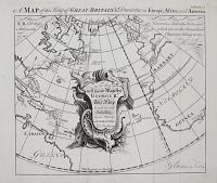
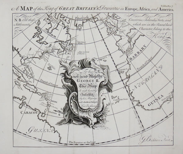
A Map of the King of Great Britain's Dominions in Europe, Africa, and America.
G. Bickham Fecit.
[n.d., 1748.]
Engraving. 280 x 315mm (11 x 12½"). Binding folds, worm holes in bottom margin.
A map centred on the Atlantic Ocean, showing from the Arctic Circle to the Equator, marking British possessions including Gibraltar, Minorca, the Gold Coast of Guinea and the colonies in North America and West Indies. From George Bickham's 'The British Monarchy or a Chorographical Description of all the Dominions Subject to the King of Great Britain'.
[Ref: 45602] £280.00
view all images for this item
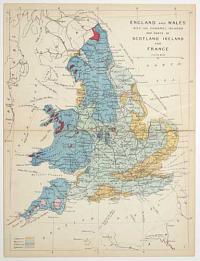
England and Wales with the Channel Islands and parts of Scotland Ireland and France.
[James Reynolds, London 1863]
Hand coloured engraving, sheet 240 x 185mm (9½ x 7¼"). Folded as issued, time staining along taped fold.
From 'Reynolds's Geological Atlas of Great Britain'. A geological map of Britain with the land colour coded by rock type.
[Ref: 56924] £30.00
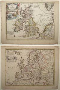
Les Isles Britanniques Suivant les Nouvelles Observations de Mess.rs de l'Academie Royale des Sciences, etc. Augmentées de Nouveau. [&] l'Europe [...]
A Amsterdam Chez Covens & Mortier [n.d., c.1730].
Two engraved maps. Both 235 x 305mm (9¼ x 12"). Pasted back to back. Tape over edge of Europe.
Two maps originally published in Pieter van der Aa's 'Atlas Curieux'.
[Ref: 57340] £260.00
view all images for this item
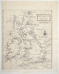
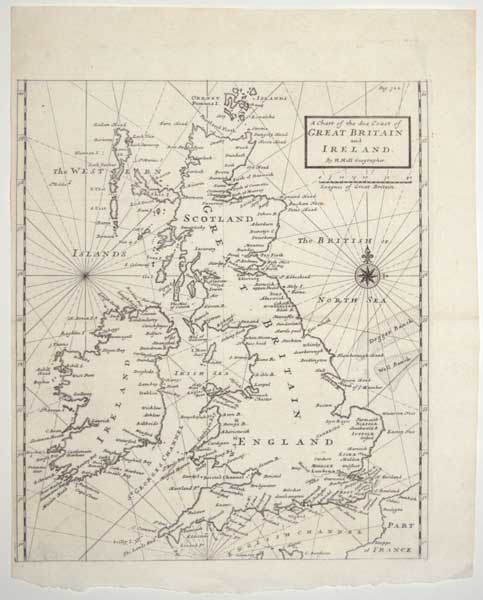
A Chart of the Sea Coast of Great Britain and Ireland.
By H. Moll Geographer.
[n.d., 1720.]
Engraved map. 320 x 285mm (12½ x 11¼"). Narrow margin on left. Original binding folds.
A sea chart of the British Isles, from Josiah Burchett's 'A Complete History of the Most Remarkable Transactions at Sea, from the Earliest Account... to the Conclusion of the Last War with France''.
[Ref: 61703] £380.00

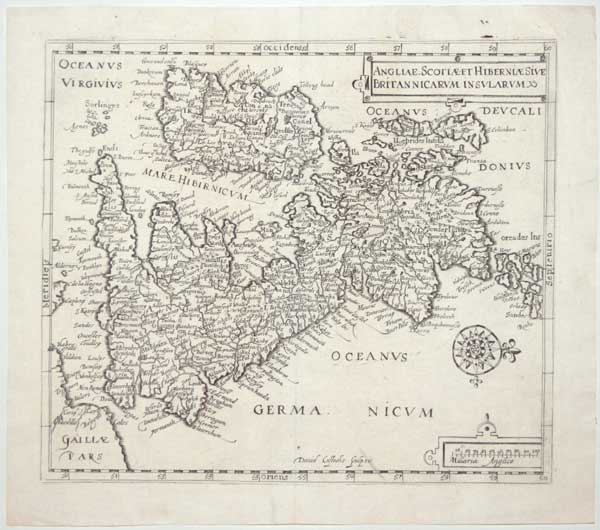
Anglie, Scotiae et Hiberniae Sive Britannicarum Insularum.
David Custodis Sculpsit.
[Frankfurt, 1627.]
Engraved map. 270 x 315mm (10¾ x 12½"). Repaired tear in bottom printed border.
Unusual map of the British Isles orientated east to west, based on the 1570 map by Abraham Ortelius but with details.
[Ref: 59230] £220.00
(£264.00 incl.VAT)
![Map of the Island of Capri, in the Gulf of Naples. [Numbered key to top left for 12 points of interest.] Plate 20, Vol. 4.](img-thumbnail/jpegs/55500.jpg)
Map of the Island of Capri, in the Gulf of Naples. [Numbered key to top left for 12 points of interest.] Plate 20, Vol. 4.
E. Gullan, sculp.
No.22, of R.Ackermann's Repository of Arts, &c. Pub. Octr. 1, 1810, at 101, Strand, London.
Engraving with added hand colour. 146 x 234mm. 5¾ x 9¼". Toning and tears around the edges.
A map of the Italian island, Capri, in the Tyrrhenian Sea off the Sorrentine Peninsula. Ackermann's Repository of Arts was an illustrated, British periodical published from 1809-1829 by Rudolph Ackermann. The formal title of the publication was "Respository of Arts, Literature, Commerce, Manufactures, Fashions, and Politics", and it did cover all of these fields. At the time, it was considered to be of great influence to the English taste in fashion, architecture, and literature.
[Ref: 55500] £95.00
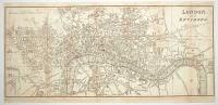
![Cary's Traveller's Companion, or, A Delineation of the Turnpike Roads of England & Wales [...]](img-thumbnail/jpegs/59721.jpg)
Cary's Traveller's Companion, or, A Delineation of the Turnpike Roads of England & Wales [...] [with] Cary's New Itinerary: or, An Accurate Delineation of the Great Roads, Both Direct and Cross, Throughout England and Wales; With many of the principal Roads in Scotland.... Second Edition with Improvements.
London. Printed for John Cary, Engraver, Map & Printseller, Strand. 1st Jan.y 1791. [&] London: Printed for John Cary, No. 181 Strand, 1802 [-3].
Two works in one; 8vo (180 x 120mm, 7 x 4¾"), original full diced calf travelling case with empty pockets front and back. 'Companion': engr. title, pp. (iv)+(6)+(2)(ads); index map, 42 maps printed back to back, 1 folding map. 'Itinerary': engr. title & dedication; pp. (iv)+(1)(ad)+868+(2)(ads). All maps with original hand colour. With the bookplate of Henry Pakenham-Mahon of Strokeston Park. Binding with tear to flap, some wear and fading. Folding map of Yorkshire with tear on fold; two folding maps of 'Itinerary' both trimmed to allow opening of segments, one segment loose, with tears on folds.
An unusual travelling edition of two works by John Cary. The 'Traveller's Companion' has a map of England and Wales, 41 counties and maps of North & South Wales. The 'Itinerary' has two road maps of England & Wales, with extensive indexes of the roads. The adverts list some of Cary's maps, with one page dedicated to his globes. The empty pockets in the covers would most likely contain larger folding maps not called for in either the 'Companion' or 'Itinerary'. Henry Pakenham-Mahon (1851-1922) was an amateur photographer: in 2012, a collection of 324 of his glass plates was uncovered at Strokestown Park including several explicit images of live models. Strokestown (in County Roscommon, Ireland) is now home to the National Irish Famine Museum. Henry's grandfather was Denis Mahon, whose responce to a rent strike by his tenants at Strokestown was to evict them and force them to sail to Quebec in 1847, filling four ships. When news came back to Ireland that nearly half the passengers had died on route (primarily from cholera) Mahon was ambushed and shot dead, to general celebration.
[Ref: 59721] £850.00
view all images for this item

Map Shewing the situation of each Roman Catholic Chapel, College & Seminary Throughout England, Scotland, And Wales. March, 1859
L. Schönberg. lith. 108 Hatton Garden.
Published for Fraser's Magazine, at 215 Regent Street, London,
Lithograph, 260 x 165mm. Extremely rare. Horizontl fold; laid on album sheet.
A map showing the locations of Roman Catholic institutions in England, Scotland and Wales.
[Ref: 11126] £220.00
Map of the Celtic and Belgic Tribes, with their Towns and Trackways in Britain, as they existed at the first invasion of Cæsar. Engraved from a Drawing by the Rev.d Thomas Leman.
Engraved under the direction of J.Norris Brewer. Neele, Sc. Strand.
Published by J.Harris, Corner of St Pauls Church Yard, December 1st 1817.
Engraved map. 310 x 270mm, 12¼ x 10¾". Trimmed within top margin, with nick, split in centrefold, as normal.
Thomas Leman (1751-1826).
[Ref: 19991] £110.00
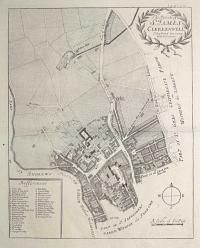
The Parish of S.t James Clerkenwell, Taken from ye last Survey with Corrections.
[n.d., c.1770.]
Engraved map, 18th century watermark. 365 x 290mm (14½ x 11½"), with very large margins.
A map of Clerkenwell centred on St John Street, marking Clerkenwell Green, St John's Priory, New River Pond and Sadler's Wells. Originally engraved for the 6th edition of Stow's 'Survey of London', 1720.
[Ref: 62526] £140.00
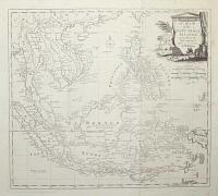
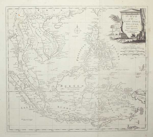
A Map of the East India Islands, agreeable to the most approved Maps and Charts, by Mr. Kitchin.
[engraved by Thomas Kitchin.]
[London, c.1785.]
Engraved map. 345 x 385mm (13½ x 15¼"), with very large margins. Original folds, some slight staining, some areas weakly inked.
A map of the East Indies, with the Malay Peninsula, Indochina, Indonesia and the Philippines. New Guinea has yet to be mapped properly. Originally published in 'Millar's New Complete & Universal System of Geography'.
[Ref: 55316] £250.00

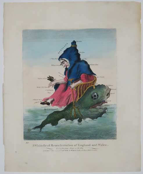
86. A Whimsical Representation of England and Wales. Being the same shape as the Map.
Published 12.th May 1794 by Laurie & Whittle, 53 Fleet Street.
Very rare hand coloured etching, 220 x 185mm (8¾ x 7¼"), with large margins. Printers crease. Tear on left just touching the plate mark taped. One very small wormhole on right middle.
The large version of this allegorical map showing England and Wales as an old hag riding a sea monster. One hand holding a trident the other suporting a small bird.
[Ref: 60693] £450.00

England and Wales.
W. Snow, Publisher Theobald's Road. [n.d., c.1815.]
Coloured engraving. Sheet 140 x 105mm. Laid on card as issued, some staining.
An anthropomorphic caricature of England and Wales as a grotesque man, frothing tankard in hand, riding a monstrous dolphin, his blue cape creating Wales. It is a smaller copy of Robert Dighton's 'Geography Bewitched'. This example appears to be an early state, before 'A Caricature of' was added above the title box.
[Ref: 42819] £320.00
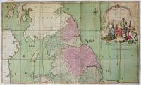
England and Wales Drawn from the most Accurate Surveys. Containing all the Cities, Boroughs, Market Towns & Villages. In Which are included all the improvements and observations both Astronomical and topographical , which have been made by Members of the Royal Society & others Down to the present year.
The whole corrected & improv'd by John Rocque, Chorographer to his Majesty.
[London: John Rocque] 1761.
Engraved map, one sheet only (of two). Dissected and laid on linen, with tab and title label in French mss. Superb original colour. 590 x 1000mm (23¼ x 39¼"). A few water streaks.
The northern half of Rocque's large format map of England and Wales, in exceptional original colour. It was published towards the end of the Seven Years' War, when the British were getting the upper hand and thus becoming the dominant world power. This is reflected in the superb title cartouches, which features Britannia with the Cap of Liberty, the British Lion and the Greek gods Athena and Mercury.
[Ref: 33686] £480.00
view all images for this item
An Ecclesiastical Map of England and Wales Shewing the Position of the Catholic Churches, Chapels, Colleges, Missions, & Relgious Houses, With the Boundaries of the Archdiocese and the Diocese, With a Plan of London Shewing the Position of the Catholic Churches &c. Together With a List of the Towns in which Catholic Churches are Established. 1851.
Designed by Daniel Grant. Lithographed by Daniel Grant & Co, 75, Fleet Street.
Sold by Charles Dolman, 61 New Bond St & 48a Paternoster Row.
Scarce lithographic map. Sheet 750 x 570mm (29½ x 22½"). Creasing and surface soiling, pinholes in corners, laid on linen.
A map of the Catholic churches and chapels in England and Wales. From the Berkeley Collection, Spetchley Park.
[Ref: 54974] £500.00
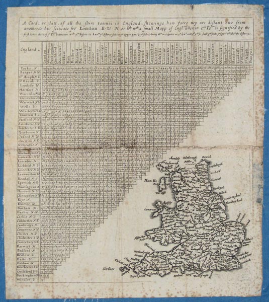
A Card, or platt, of all the shire townes in England, shewinge how farre they are distant one from another, & how scituate fro London, E.W.N. or Sth, wth a small Mapp of England ...
[Engraved by Jacob Florensz van Langren.]
[n.d., c.1660.]
Engraved distance chart and map, 240 x 210mm. 9½ x 8¼". Foxing, split in fold repaired but misaligned.
A chart of the distances between certain towns in England and Wales. Plate from Matthew Simmons' 'A direction for the English traviller by which he shal be inabled to coast about all England and Wales. And also to know how farre any market or noteable towne in any shire lyeth one from an other ... As also the distance betweene London and any other shire or great towne ...'. First published by Thomas Jenner, 1643. Shirley: 468, II of III.
[Ref: 10701] £650.00
![[Britain] Carte de la Manche faite par ordre du Roy](img-thumbnail/jpegs/3426.jpg)
[Britain] Carte de la Manche faite par ordre du Roy
A Paris Chez Hubert Jaillot, 1692.
Engraved chart. Two sheets conjoined, total 595 x 810mm.
Detailed chart of the English Channel, from the monumental 'Neptune Françoise'.
[Ref: 3426] £320.00
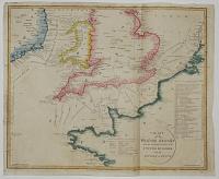
Chart of the British Channel with the Opposite Coast of the United Kingdom, and the Republic of France.
Drawn and Engraved by J. Russell.
London. Published as the Act directs November 5th 1803 by J. Stratford, Holborn Hill.
Coloured engraved map, rare. 340 x 420mm, 13½ x 16½". Impression weak in places, especially the publication line, tears in binding folds.
Despite the title this map shows the British Isles as far north as Dublin, Liverpool and Spurn Head. The map's purpose is to show the potential landing sites of the feared French invasion following the collapse of the Peace of Amiens in May that year. A table lists the landing sites of various invading armies in Britain and Ireland since the Normans in 1066.
[Ref: 26308] £280.00
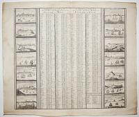
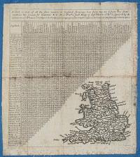
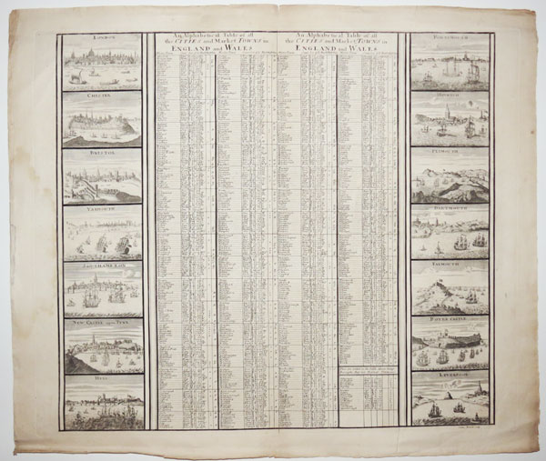
An Alphabetical Table of all the Cities and Market Towns in England and Wales.
Sutton Nicholls sculp.
[London: John Smith, c.1724.]
Engraving, rare in this pre cut state. 505 x 590mm (19¾ x 23¼"). Chips in edges.
An engraved table of market towns, edged with fourteen prospects of cities. On the left are London, Chester, Bristol, Yarmouth, Southampton, Newcastle-upon-Tyne and Hull; on the right are Portsmouth, Harwich, Plymouth, Dartmouth, Falmouth, Dover Castle and 'Leverpool'. The title is repeated because the sheet is usually bissected and pasted on the sides of 'A New Map of South Britain or England and Wales', the index map of Smith's 'Britannia Illustrata'.
[Ref: 45232] £580.00
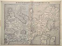
Europa das ein drittheil der erden / nach gelegenheit unsern zeiten.
[Basle, Heinrich Petri, c.1550.]
Woodcut. Sheet 282 x 375mm (11 x 14¾"). Margin bottom left restored, tape stains in edges. Evidence of cracks in the woodblock.
Munster's famous upside-down map of Europe, although omitting most of Scandinavia, Scotland and half of Ireland. Despite the strange orientation (a German convention to align maps with the solar compass) it is the first map of the continent not based on Ptolemy. The map was first used in Munster's edition of Ptolemy's 'Geographia' in 1540 and also appeared in his 'Cosmographia'; the cracks in the woodblock first appeared in 1545. A new, similar block was used from 1571-2 until 1578, when a new map, copied from Ortelius, was introduced.
[Ref: 55504] £990.00
view all images for this item
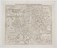
Europa nach Gelegenheit unserer Zeit New Beschrieben.
[Basle: c.1588.]
Woodcut. Printed area 320 x 360mm (12½ x 14"). Slight creasing.
A woodcut map of Europe, copied from Ortelius's map of 1570, replacing the famous upside-down map of Europe in editions of Munster's 'Cosmographia' from 1588. Sebastian Münster (1488-1552) was a Christian Hebraist scholar as well as a cartographer and cosmographer. His 'Cosmographia', first published in 1544, is the earliest German description of the world.
[Ref: 30680] £280.00
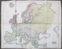
Europe after the Congress of Vienna. A Map of Europe with the Political Divisions after the Peace of Paris and the Congress of Vienna.
Drawn and Engraved for Thomson's New General Atlas. [Edinburgh, c.1823.]
Engraved map on four sheets conjoined, fine original colour. Total 1055 x 1310mm (41½ x 51"), on Whatman paper watermarked 1823. Tears at folds.
A wall map of Europe as divided up by the Congress of Vienna, 1815, at the close of the Napoleonioc Wars. While British gains were outside Europe, the gains of Russia, Prussia and Austria were confirmed, to the detriment of Poland, Saxony, Pomerania. Also the neutrality of Switzerland was guaranteed and the slave trade condemned.
[Ref: 26797] £280.00

An Accurate Map of Great Britain, France & Ireland, with Part of Spain, Germany, Denmark &c. Shewing at One View the True Bearing and Horizontal Distance, of any Place within 700 Miles of London; Drawn from the Best Authorities.
Published 12th May, 1794 by Laurie & Whittle, 53 Fleet Street, London.
Engraved map with fine hand colour. Sheet 530 x 535mm, 20¾ x 21". Trimmed to printed border at top, narrow margins on other edges; tear near centrefold at top.
An unusual hemispherical projection centred on London, allowing the compass bearings to be shown as straight lines. The 700 miles from London reaches the Faroe Islands, Bergen in Norway, Munich in Germany, Parma in Italy, the northern coasts of Majorca and Minorca, and Galicia in Spain.
[Ref: 21201] £450.00
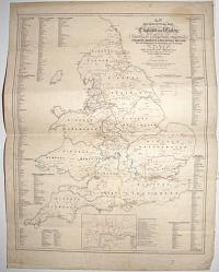
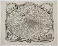
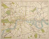
![Geological Survey of England and Wales. Index Map Sheet 11 [Somerset, Wiltshire, Gloucestershire, Oxfordshire and Monmouthshire, etc].](img-thumbnail/jpegs/59730.jpg)
Geological Survey of England and Wales. Index Map Sheet 11 [Somerset, Wiltshire, Gloucestershire, Oxfordshire and Monmouthshire, etc].
Wyman & Sons Ltd. Lith, 63, Carter Lane, 8575.7.96.
Engraved and Published at the Ordnance Survey Office, Southampton, in 1891[-6].
Chromolithographic map. Dissected and laid on linen, as issued, sheet 670 x 905mm (26½ x 35½"), folded into buckram covers with 'G Philip & Son' label with mss. title. Splits in linen.
A colourful geological map, covering from Taunton in the south west, clockwise to Merthyr Tydfil, Hereford, Buckingham, Oxford, Reading, Winchester and Sherbourne. This index sheet covered twelve sheets of the 1 inch series of geological maps.
[Ref: 59730] £260.00
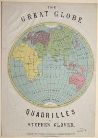
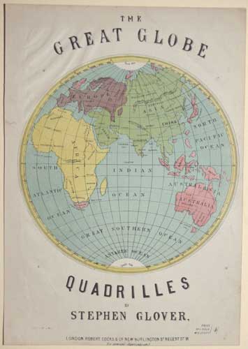
The Great Globe Quadrilles by Stephen Glover
[S. Rosenthal lith.]
London: Robert Cocks & C.o New Burlington S.t Regent S.t W. [n.d. c.1870]
Colour lithograph. 330 x 240mm (13 x 9½"). Trimmed with creasing in the top left corner and a small repaired tear in the upper left margin. Two worm holes in top left and bottom right corners.
An illustrated cover of the Eastern hemisphere for the sheet music to Stephen Glover's 'Quadrilles'.
[Ref: 56908] £190.00
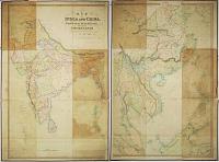
Map of India and China , Burmah, Siam, Malay, Peninsula and the Empire of Anam, Compiled from the latest Surveys, &c. &c. W.m H. Allen & Co., 7 Leadenhall Street, London, 1844.
Drawn & Engraved by J. & C. Walker.
Published as the Act directs by W.m H. Allen & Co., 7 Leadenhall St., May 13th 1844.
Engraved map with original body colour. Dissected and laid on linen in two sections, each 1000 x 670mm. Some colour oxidation.
A map showing from Afghanistan to the Philippines, highlighting the British interests in the East, with Hong Kong marked in red, only two years after the Treaty of Nanking made the islands a Crown colony. 'Anam' (more correctly Annam) is Vietnam.
[Ref: 29892] £950.00
view all images for this item
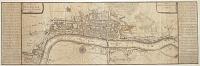
![[St John's Wood, Kilburn & Kensal Green] Sheet 5. Stanford's Library Map of London and its Suburbs.](img-thumbnail/jpegs/61750.jpg)
[St John's Wood, Kilburn & Kensal Green] Sheet 5. Stanford's Library Map of London and its Suburbs.
London: Published by Edward Stanford, 6 Charing Cross Feb. 15.th 1862.
Engraved map with hand colour. Sheet 350 x 425mm (13¾ x 16¾"). Stained, laid on card.
One sheet of a 24-sheet map of London, showing St John's Wood as the northern limit of London's conurbation, with Kilburn, Kensal Green Cemetery and Willsden surrounded by fields.
[Ref: 61750] £180.00
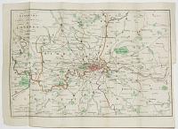
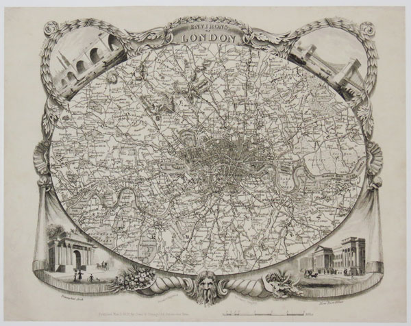
Environs of London.
Drawn and Engraved by James Bingley.
Published Nov 3 1828 by Cowie & Strange, 64 Paternoster Row.
Rare steel-engraved map. Sheet 210 x 270mm (8¼ x 10½"). Small repaired tear affecting publisher's inscription.
An oval map of the environs of London, extending to Finchley in the north, clockwise to Tottenham, Barking, Woolwich, Norwood, Tooting, Wimbledon, Richmond, Brentford and Hendon. Within the decorative borders are vignette view of London Bridge, Hammersmith, Hyde Park Corner and the Post Office. At the bottom is the head of Old Father Thames and twin cornucopiæ (horns of plenty) filled with fruits and jewels representing the trade coming up the river. The design of this separate-issue map was later copied by Thomas Moule for his county atlas. Howgego No. 315.
[Ref: 37605] £280.00

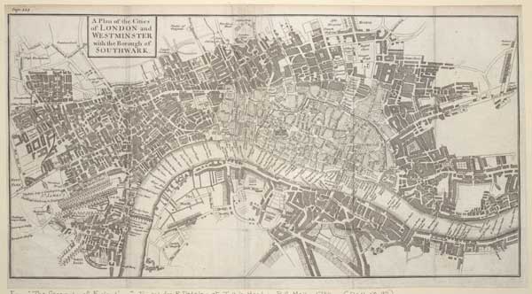
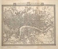
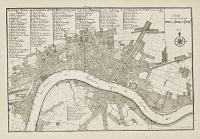
A Correct Plan of the Cities of London and Westminster & Borough of Southwark, including the Bills of Mortality, with the Additional Buildings &c. Engraved from a New Survey for the London Magazine 1761.
Engraved map. 230 x 410mm (9 x 16"). Trimmed into plate on left, original binding folds.laid on card.
A map of London based on John Rocque's important 24-sheet map of 1746. The Bills of Mortality were the areas in Greater London that reported death notices directly to the London government. Darlington & Howgego 118.
[Ref: 61741] £360.00
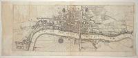
A Plan of London as in Q. Elizabeths days.
London. Printed for T. Bowles at N.º 43 in Cornhill [n.d., c.1750].
Engraved map. Sheet 175 x 550mm (6¾ x 21¾"). Trimmed to printed border, losing half of plate; paper toned, some stains.
A map of London in Tudor times, based on the large woodcut map often attributed to Ralph Agas. Originally published c. 1700 by John Bowles. The missing lower half of the plate contained a prospect of London after Visscher and five views.
[Ref: 61744] £450.00
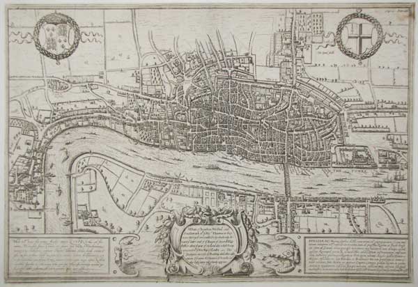
![Londinium Antiqua. This Plan shews the ancient extent of the famous cities of London and Westminster as it was near the begining of the Reign of Queen Elizabeth [...]](img-thumbnail/jpegs/35662.jpg)
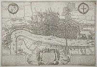
Londinium Antiqua. This Plan shews the ancient extent of the famous cities of London and Westminster as it was near the begining of the Reign of Queen Elizabeth [...]
Vertue, Soc. Antiq. London excudit 1737.
Engraving on pewter, two sheets (of eight) conjoined, total 355 x 940mm. Repairs to folds. Ink stamps of the Paul Mellon Collection on reverse.
The bottom left corner of a map of Tudor London, engraved on pewter by George Vertue from a comtemporary woodcut in the possession of Sir Hans Sloane. The strip here shows Westminster, Whitehall, Lambeth Palace and Charing Cross, the buildings south of the Strand and Fleet Street, to St Paul's Cathedral and Barnard's Castle. Under the title is a list of buildings not present, as a guide to dating the map. Three examples of an anonymous woodcut map of London c.1570 exist, all now in institutions. Vertue, an enthusiastic member of the Society of Antiquaries, researched the map and attributed it to Ralph Agas (c.1540-1621), solely on the basis of a letter in which Agas spoke of his intentions of making such a plan. The style is much the same as Braun & Hogenberg, with the buildings shown in profile, and many of the details are shared. However on this plan St Paul's Cathedral is without the spire hit by lighting and destroyed in 1561 (not shown here as the building runs off the top of the present sheet). Howgego: Printed Maps of London 8, and the introduction pp.7 - 8.
[Ref: 35662] £1,800.00
A Plan of London and its Environs. Drawn and Engraved for Lewis' Topographical Dictionary.
Drawn by R. Creighton. Engraved by J. & C. Walker.
[n.d., c.1831.]
Engraved map. Sheet 430 x 510mm (17 x 20"). Trimmed within plate on left, folds, laid on album paper.
A detailed map of central London, an example of the first state, before the addition of London's first steam railway, the London and Greenwich Railway (opened between 1836-38). Darlington & Howgego 330.
[Ref: 61731] £260.00
London.
Published as the Act directs Feb.y 1815 by G. Jones, Ave Maria Lane.
Engraved map. Sheet 255 x 405mm (10 x 16"). Vertical fold, laid on card.
A Georgian plan of London, published a matter of months before the Battle of Waterloo. It shows from the Serpentine River in Hyde Park, clockwise to Paddington, Regent's Park, Hackney, Stratford, the East India Docks, Greenwich, Walworth, Nine Elms and Chelsea. The map shows Regent's Park and the Millbank Penitentiary under construction, and 'Tomlins Town', a shanty town for workers off the Edgware Road. Darlington & Howgego 265.
[Ref: 61729] £260.00
A View of London about the Year 1560. Reduced to this Size from a Large Print in the Collection of S.r Hans Sloane Bar.t anno 1738.
Etched map. Sheet 310 x 470mm (12¼ x 18½"). Trimmed within plate, binding folds as normal, stains.
A map of Tudor London, based on the so-called 'Agas' woodcut map, showing St James's Park east to Whitechapel, with a 47-point key.
[Ref: 57269] £280.00
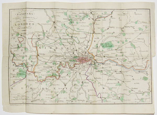
Panorama des Environs Londres, Par A.M. Perrot.
Gravé par Legagneur, Rue de la Harpe, No. 35.
[n.d., but 1828.]
Engraved map with original colour. Printed area 210 x 310mm (8¼ x 12"). Folded as issued.
A tourist's map of the environs of London, extending from Windsor east to Gravesend and from Ware south to Reigate. From the 'Guide de l'Étranger a Londres'.
[Ref: 37603] £260.00
Plan des Villes de Londres et de Westminster et de leurs Faubourgs avec le Bourg de Southwark.
C. Inselin sculp.
Avec Priv. du Roy 1700.
Engraved map. Plate: 340 x 230mm (13½ x 9"), with wide margins.
Nicolas de Fer's map of London showing the City of London and Westminster.
[Ref: 42750] £390.00
A Plan of the Cities of London and Westminster with the Borough of Southwark.
[London: R. Dodesley, 1744.]
Engraved map. Sheet 230 x 420mm (9 x 16½"). Trimmed within plate on three sides, folds and creasing, slight ink offset, laid on album sheet
A map of London, extending from Park Lane in the west, clockwise to Marylebone, Sadlers Wells, Hoxton, Bethnal Green, Rotherhithe and Lambeth. The map shows the extent of the damage caused by the Great Fire of 1666. From "The Geography of England". Darlington and Howgego 92.
[Ref: 61743] £360.00
Clue Plan for Collins's Illustrated Guide To London By J. Batholomew.
William Collins, Sons & C.º London, Glasgow & Edinburgh [n.d., c.1871.]
Rare wood-engraved map, printed in colours and hand finished. Sheet 190 x 365mm (7½ x 14¼"). Original folds, mounted on card at corners.
A map of the roads of London, with landmarks and railways. Not in Hyde's Victorian Maps of London.
[Ref: 61749] £360.00
London.
[London: David Hughson, 1817.]
Engraved map. Sheet 260 x 545mm (10¼ x 21½"). Original folds. Slight staining.
A Georgian plan of London, showing from Hyde Park in the west, clockwise to the Euston Road (New Road), Somers Town, Islington, Mile End Road, Limehouse, Lambeth and Knightsbridge. The map still shows Lord's Cricket Ground in its original site, as well as Park Farm and Jews Harp House, both mentioned in William Blake's poem 'Jerusalem': 'The Jews-harp-house & the Green Man; / The Ponds here Boys to bathe delight: / The fields of Cows by Willans farm: Shine in Jerusalems pleasant sight'. Both were to be soon subsumed into Regent's Park. Darlington & Howgego 270.
[Ref: 61730] £260.00
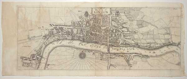
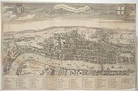
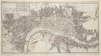
A Plan of London Westm.r and Southwark w.th ye Riv.r Thames, as they were Surveyd and publish't by Authority toward ye latter end of ye Raign of Queen Elizabeth; or about ye year of our Lord 1600. which being compared w.th ye New Map of London ~ The prodigious increase of Building and other alterations of ye names & Situation of Street &c. in this last centry will plainly apperar.
[engraved by Frans Hogenberg.]
[London: Edward Hatton, 1708.]
Engraved map. Sheet 330 x 480mm (13 x 19"). Trimmed close to printed border, laid on card.
The last state of the famed Braun & Hogenberg map of London, originally published in 1572, but showing London before the destruction of the spire of the Norman St Paul's Cathedral in 1561 (during the reign of Mary I). After passing through the hands of publisher Jan Jannson in Amsterdam (who removed the original title and engraved a new cartouche over the original costumes), the plate was bought by a London publisher and used in Hatton's ''A New View of London; or, an Ample Account of that City'', with an English title replacing the Latin. The original issue is the earliest printed map of London to survive. Howgego: 2, state 4.
[Ref: 61721] £1,800.00
The City of London as in Q. Elizabeth's Time.
[n.d., 1720.]
Etched map. 185 x 465mm (7¼ x 18¼"). Binding folds, a little staining.
A map of Tudor London, published in 'Stow's Survey of London'. It is based on the so-called 'Agas' woodcut map, it shows St James's Park east to Whitechapel.
[Ref: 57268] £380.00
Panorama de Londres, Par A.M. Perrot.
Gravé par Legagneur, Rue de la Harpe, No. 35.
[n.d., but 1828.]
Engraved map with original colour. Sheet 355 x 450mm (14 x 17¾"). Folded as issued, trimmed to printed border on right.
A tourist's map of London, showing only the major roads, extending from Hyde Park east to the East India Docks and from Kentish Town south to Kennington. From the 'Guide de l'Étranger a Londres'.
[Ref: 37602] £260.00

![[The Arctic Circle on globe sheets.]](jpegs/10905.jpg)

![[Untitled map of Bath]](jpegs/59729.jpg)


![Auszug aus einer See-Charte die Andreas Bianco im I[ahr] 1436 zu Venedig verfertigte...](jpegs/53128.jpg)


![Map of the Island of Capri, in the Gulf of Naples. [Numbered key to top left for 12 points of interest.] Plate 20, Vol. 4.](jpegs/55500.jpg)
![Cary's Traveller's Companion, or, A Delineation of the Turnpike Roads of England & Wales [...]](jpegs/59721.jpg)


![[Britain] Carte de la Manche faite par ordre du Roy](jpegs/3426.jpg)


![Geological Survey of England and Wales. Index Map Sheet 11 [Somerset, Wiltshire, Gloucestershire, Oxfordshire and Monmouthshire, etc].](jpegs/59730.jpg)

![[St John's Wood, Kilburn & Kensal Green] Sheet 5. Stanford's Library Map of London and its Suburbs.](jpegs/61750.jpg)


![Londinium Antiqua. This Plan shews the ancient extent of the famous cities of London and Westminster as it was near the begining of the Reign of Queen Elizabeth [...]](jpegs/35662.jpg)