Results 1-17 of 17
<<< Previous 1 Next >>>
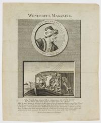
Ali Mustapha. Born at Candie 1734. His beard they burnt, then vengeance the Turk hurl'd On all near him, and kill'd would have the World [...]
Drawn from Nature by a Passenger.
Sep.r 6th 1787
Engraving, sheet 220 x 170mm (8½ x 6¾"). Creases.
According to an often-reprinted story, Ali Mustapha was a Turk who, travelling economically on a barge in France, was sleeping when his fellow passengers set fire to his beard. Upon awaking (as the text and image here recount), the enraged Ali Mustapha killed several people on board the barge and 'could not be stop'd till he was shot with a Pistol, of which wounds he died at Sens three Days after'. From the 'Wonderful Magazine', which specialized in extraordinary events.
[Ref: 37947] £130.00
(£156.00 incl.VAT)
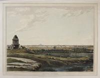
East View of Bangalore.
Drawn on the spot by R.H.Colebrooke. Engrav'd by J.W.Edy.
London: Pub.d April 1. 1793, for the Proprietor, by Mr. Thomson, No.22, Great Mary le bone.
Fine hand coloured aquatint J Whatman watermark; Platemark: 445 x 580mm (17½ x 22¾"). Small margins; small tears to upper edge of sheet.
An east view of Bangalore, with a small shrine and a dismounted horseman in the foreground to the left, and cattle grazing beyond. Engraved by John William Edy as plate 1 of Robert Hyde Colebrooke's (1762-1808) 'Twelve Views of Places in the Kingdom of Mysore', published by Thomson, London, 1793-94.
[Ref: 38728] £650.00
Unfortunately this item is either sold or reserved. If you are interested in similar items and cannot find what you're looking for on our website, please consider filling in our interests form. If you register, we can also send you items that match your interests when the website is updated.
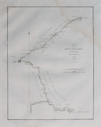
A Sketch of the Pey-Ho or White River, and of the Road from Pekin to Geho taken in 1793.
By H.W. Parish Royal Artillery. Engraved by B. Baker Islington.
Published April the 12th, 1796 by George Nicol.
Engraved map. Sheet 560 x 420mm (22 x 16½").
A detailed map of the Hai River from the coast to Beijing and down the Imperial Road to Chengde (Jehol) to see the Emperor. The route was mapped by members of the George Macartney mission to China, the first British embassy to that country, 1792-94. The chart was published in Sir George Staunton's 'An Authentic Account of an Embassy from the King of Great Britain to the Emperor of China'. See item ref: 37515, 'Narrative of the British Embassy to China In the Years 1792, 1793 and 1794' for a detailed account of Æneas Anderson's voyage to China in the service of Lord Macartney, including a list of the retinue of Lord Macartney and a Glossary of Chinese words.
[Ref: 38162] £240.00
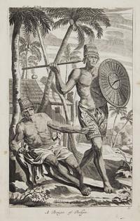
A Bougis of Bokjes. 35
[after Johann Nieuhof.]
[London, c.1732.]
Engraving. 300 x 180mm (12 x 7¼"). Large margins.
A pair of tribesmen from the Dutch East Indies. From Niuehof's account of his travels in Asia as published in Awnsham and John Churchill's 'Collection of Voyages and Travels'.
[Ref: 38557] £140.00
(£168.00 incl.VAT)

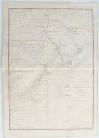
Sketch of A Journey from Hang-Tchoo-Foo To Quang-Tchoo-Foo or Canton in China. by J. Barrow.
Engraved by B. Baker Islington.
Published April the 12th, 1796 by George Nicol.
Engraved map. 670 x 500mm (26¼ x 19¾"). Staining top & bottom.
The second part of the route across China taken by the George Macartney mission after meeting the Emperor. Starting in Hangzhou on the Yangtze River delta they passed Nankin on route to Canton, where they met the ships that were to take them home. It was published in Sir George Staunton's 'An Authentic Account of an Embassy from the King of Great Britain to the Emperor of China', the first British embassy to China. See item ref: 37515, 'Narrative of the British Embassy to China In the Years 1792, 1793 and 1794' for a detailed account of Æneas Anderson's voyage to China in the service of Lord Macartney, including a list of the retinue of Lord Macartney and a Glossary of Chinese words.
[Ref: 38163] £220.00
A Chart on Mercator's Projection, containing the Track and Soundings of the Lion, the Hindostan and Tenders, from Turon-Bay in Cochin-China to the mouth of Pei-Ho River in the Gulf of P-Tche-Lee or Pekin by J. Barrow.
Engraved by B. Baker Islington.
Published April 12, 1796 by George Nicol.
Engraved map. 740 x 520mm (29 x 20½"). Staining.
A map of the coast between Da Nang in Vietnam and Beijing in China illustrating the route taken by the George Macartney mission to China, the first British embassy to that country, 179294. It was published in Sir George Staunton's 'An Authentic Account of an Embassy from the King of Great Britain to the Emperor of China'. Shows site of Hong Kong. See item ref: 37515, 'Narrative of the British Embassy to China In the Years 1792, 1793 and 1794' for a detailed account of Æneas Anderson's voyage to China in the service of Lord Macartney, including a list of the retinue of Lord Macartney and a Glossary of Chinese words.
[Ref: 38158] £420.00
![Dardanel d'Natolia. [&] Dardanel ver Grecia.](img-thumbnail/jpegs/38553.jpg)
Dardanel d'Natolia. [&] Dardanel ver Grecia.
[Engraved by Giuseppi Rosaccio.]
[Padua: Conzatti, 1713.]
Pair of engravings, set in letterpress. Sheet 330 x 220mm (13 x 4¾2).
A pair of views of the two Ottoman forts that guarded the Dardanelles, one on Asia, the Europe. On the reverse is another map of the source of the Danube. Originally published in Rosaccio's 'Viaggio da Venetia a Constantinopoli' (1598), this sheet comes from 'Universus terrarum orbis scriptorum calamo delineatus ... qui de Europae, Asiae, Africae, & Americae regnis, provinciis, populis, civitatibus...', a geographical and historical dictionary by Alphonse Lasor à Varea (pseudonym of Raffaello Savonarola, d. 1748). Despite the plates being over a century old the only alteration is a rudementary attempt to scratch out the plate numbers top left.
[Ref: 38553] £140.00
(£168.00 incl.VAT)
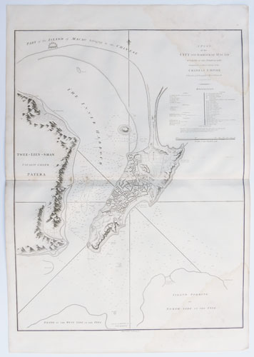
A Plan of the City and Harbour of Macao A Colony of the Portuguese situated on the southern extemity of the Chinese Empire.
Engraved by B. Baker Islington.
Published April the 12th, 1796 by George Nicol.
Engraved map. 710 x 560mm (18 x 22"). Staining top & bottom right.
A detailed map of Macao. published in Sir George Staunton's 'An Authentic Account of an Embassy from the King of Great Britain to the Emperor of China', the first British embassy to China. The 37-point key lists forts, parishes, colleges, covents, chapels and other buildings of interest including the Customs House and the English Factory. See item ref: 37515, 'Narrative of the British Embassy to China In the Years 1792, 1793 and 1794' for a detailed account of Æneas Anderson's voyage to China in the service of Lord Macartney, including a list of the retinue of Lord Macartney and a Glossary of Chinese words.
[Ref: 38164] £650.00
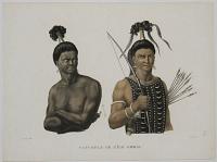
Naturels de L'Île Ombai.
J.s. Arago delin.t. Forget sculp.t.
[n.d., c. 1820].
Hand-coloured stipple with some engraving. Sheet: 325 x 240mm (12¾ x 9½"). Trimmed.
Portraits of two figures from the island of Ombia. Papua New Guinea. The figures wear their hair in tall bands, decorated with flowers. The figure on the right holds a bow and holds several arrows under his arm. From 'Voyage autour du monde...' by Louis Freycinet.
[Ref: 35091] £95.00
(£114.00 incl.VAT)

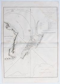
A Sketch by Compass of the Coast of the Promontory og Shan-tung with the Track of the Ships and the Soundings from the place of first making the Land to the Strait of Mi-A-Tau. By J. Barrow 1793.
Engraved by B. Baker Islington.
Published April 12, 1796 by George Nicol.
Engraved map. 695 x 540mm (27½ x 21¼") Staining top & bottom.
A chart of the coast around Shandong, mapped by members of the George Macartney mission to China, the first British embassy to that country, 1792-94. A view shows the passage between Zhifu Island and Kongtong Island. The chart was published in Sir George Staunton's 'An Authentic Account of an Embassy from the King of Great Britain to the Emperor of China'. See item ref: 37515, 'Narrative of the British Embassy to China In the Years 1792, 1793 and 1794' for a detailed account of Æneas Anderson's voyage to China in the service of Lord Macartney, including a list of the retinue of Lord Macartney and a Glossary of Chinese words.
[Ref: 38161] £260.00
View of the City of Ten-Tchoo-Foo from the anchorage of the Hindostan in the Strait of Mi-A-Tau bearing South-west.
Ellis sculp.t.
London, Published April 12, 1796, by G.Nicol.
Engraving. 545 x 745mm (21½ x 29¼"), on paper watermarked 'J. Whatman 1794.' Central vertical fold as published.
Three views of the Shantung Peninsula. A panoramic view of the harbour and city of Ten-Tchoo-Foo is shown at the bottom. Cape Macartney, Staunton's Island and Cape Gower are illustrated above. Plate 7 from Sir George Staunton's 'An Authentic Account of an Embassy from the King of Great Britain to the Emperor of China', describing the expedition of Lord Macartney (1737 - 1806) as the first British ambassador to China. See item ref: 37515, 'Narrative of the British Embassy to China In the Years 1792, 1793 and 1794' for a detailed account of Æneas Anderson's voyage to China in the service of Lord Macartney, including a list of the retinue of Lord Macartney and a Glossary of Chinese words.
[Ref: 38153] £250.00
(£300.00 incl.VAT)
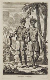
Tymorian Souldiers. 34
[after Johann Nieuhof.]
[London, c.1732.]
Engraving. 300 x 180mm (12 x 7¼"). Large margins.
A pair of tribesmen from Timor the Dutch East Indies. From Niuehof's account of his travels in Asia as published in Awnsham and John Churchill's 'Collection of Voyages and Travels'.
[Ref: 38558] £160.00
(£192.00 incl.VAT)
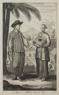
A Topas or Mardick with his Wife. 37
[after Johann Nieuhof.]
[London, c.1732.]
Engraving. 300 x 180mm (12 x 7¼"). Large margins.
Showing Pigs in a pigsty with a Topass couple, a mixed-race group in south-east Asia claiming Portuguese ancestry. From Niuehof's account of his travels in Asia as published in Awnsham and John Churchill's 'Collection of Voyages and Travels'.
[Ref: 38556] £160.00
(£192.00 incl.VAT)
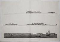
View in Turon Bay.
W. Alexander del. J. Landseer sculp.t.
London, published April 12, 1796, by G. Nicol.
Engraving, very large margins. On watermerked paper, 'J. Whatman 1794.' Platemark: 250 x 210mm. (9¾ x 8¼").
A view in Vietnam of a beach with a thatched dwelling and figures watching a boat approaching land with dignitaries under parasols at the bow. Two sailing ships can be seen behind at left with mountains in the distance. Plate 15 from Sir George Staunton's 'An Authentic Account of an Embassy from the King of Great Britain to the Emperor of China', describing the expedition of Lord Macartney (1737 - 1806) as the first British ambassador to China. See item ref: 37515, 'Narrative of the British Embassy to China In the Years 1792, 1793 and 1794' for a detailed account of Æneas Anderson's voyage to China in the service of Lord Macartney, including a list of the retinue of Lord Macartney and a Glossary of Chinese words.
[Ref: 38148] £180.00
(£216.00 incl.VAT)
![[Vietnam] Natives of Cochin-China, Playing at Shittlecock with their Feet.](img-thumbnail/jpegs/38151.jpg)
[Vietnam] Natives of Cochin-China, Playing at Shittlecock with their Feet.
W. Alexander del. J. Landseer & J. Shirt sculp.
London, Published April 12, 1796, by G. Nicol.
Engraving, very large margins. On watermarked paper, 'J. Whatman 1794.' Platemark: 210 x 255mm. (8¼ x 10").
A game played with a shuttlecock by the inhabitants of a village in the Cochinchina region, now encompassing the southern part of Vietnam. Plate 14 from Sir George Staunton's 'An Authentic Account of an Embassy from the King of Great Britain to the Emperor of China', describing the expedition of Lord Macartney (1737 - 1806) as the first British ambassador to China. See item ref: 37515, 'Narrative of the British Embassy to China In the Years 1792, 1793 and 1794' for a detailed account of Æneas Anderson's voyage to China in the service of Lord Macartney, including a list of the retinue of Lord Macartney and a Glossary of Chinese words.
[Ref: 38151] £190.00
(£228.00 incl.VAT)
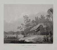
![[Da Nang]. A Chart of part of the Coast of Cochin-China Including Turon Harbour and the Island Callao](img-thumbnail/jpegs/38157.jpg)
[Da Nang]. A Chart of part of the Coast of Cochin-China Including Turon Harbour and the Island Callao From an actual Survey in 1793.
J. Barrow del.t. B. Baker sculp.t.
Published April 12, 1796 by George Nicol.
Engraved map. Sheet 560 x 420mm (22 x 16½"). Staining bottom left & top right.
A map of the coast around Da Nang in Vietnam with a coastal profile, sketched by members of the George Macartney mission to China, the first British embassy to that country, 1792-94. It was published in Sir George Staunton's 'An Authentic Account of an Embassy from the King of Great Britain to the Emperor of China'. Da Nang is now most famous for the huge American airbase there during the Vietnam War. See item ref: 37515, 'Narrative of the British Embassy to China In the Years 1792, 1793 and 1794' for a detailed account of Æneas Anderson's voyage to China in the service of Lord Macartney, including a list of the retinue of Lord Macartney and a Glossary of Chinese words.
[Ref: 38157] £260.00

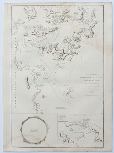
A Chart of the Islands to the Southward of Tchu-San on the Eastern Coast of China generally laid down from one published by Alexander Dalrymple Esq with additions and alterations by J Barrow.
Engraved by B. Baker Islington.
Published April 12, 1796 by George Nicol.
Engraved map. Sheet 560 x 420mm (22 x 16½"). Staining at bottom left & top right.
A chart of the coast around Ningbo, including Zhousan and other islands, mapped by members of the George Macartney mission to China, the first British embassy to that country, 1792-94. Insets show a 360° circular panorama of Zhousan harbour and a detail of the south ocast of the island. The chart was published in Sir George Staunton's 'An Authentic Account of an Embassy from the King of Great Britain to the Emperor of China'. See item ref: 37515, 'Narrative of the British Embassy to China In the Years 1792, 1793 and 1794' for a detailed account of Æneas Anderson's voyage to China in the service of Lord Macartney, including a list of the retinue of Lord Macartney and a Glossary of Chinese words.
[Ref: 38159] £230.00
<<< Previous 1 Next >>>


![Dardanel d'Natolia. [&] Dardanel ver Grecia.](jpegs/38553.jpg)


![[Vietnam] Natives of Cochin-China, Playing at Shittlecock with their Feet.](jpegs/38151.jpg)
![[Da Nang]. A Chart of part of the Coast of Cochin-China Including Turon Harbour and the Island Callao](jpegs/38157.jpg)