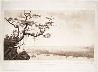
![[Dominica] The Layeau Valley. From the Sea.](img-thumbnail/jpegs/53597.jpg)
[Dominica] The Layeau Valley. From the Sea.
[after Lieutenant Whitworth Porter and Mrs Anne Porter.]
[n.d., 1849.]
Tinted lithograph. Printed area 175 x 230mm (7 x 9"). Narrow margins top and right.
One of eleven views from the rare book 'Views in the Island of Dominica' which was, according to Abbey, probably published for private circulation. First Lieutenant, Whitworth Porter (1827-92) was in Dominica from 1847-50 with his wife Anne. He later served in the trenches of Sebastopol during the Crimean War (publishing a book about his experiences), where he was promoted to brevet-major, then Captain in 1859. He was appointed commanding Royal Engineer at Barbados in 1874, then commanding Royal Engineer of the western district, stationed at Plymouth, 1877. He retired with the honorary rank of major-general in 1881. Major interest to Malta collectors. He wrote "A History of the Knights of Malta" and was connected to the "Order of St. John & Jerusalem". Abbey Travel: 695.
[Ref: 53597] £160.00
(£192.00 incl.VAT)
![[Dominica] Government House. From the Ruins of the Old Government House.](img-thumbnail/jpegs/53598.jpg)
[Dominica] Government House. From the Ruins of the Old Government House.
[after Lieutenant Whitworth Porter and Mrs Anne Porter.]
[n.d., 1849.]
Tinted lithograph. Printed area 175 x 230mm (7 x 9"). Narrow margins top and right, abrasion in sky.
One of eleven views from the rare book 'Views in the Island of Dominica' which was, according to Abbey, probably published for private circulation. First Lieutenant, Whitworth Porter (1827-92) was in Dominica from 1847-50 with his wife Anne. He later served in the trenches of Sebastopol during the Crimean War (publishing a book about his experiences), where he was promoted to brevet-major, then Captain in 1859. He was appointed commanding Royal Engineer at Barbados in 1874, then commanding Royal Engineer of the western district, stationed at Plymouth, 1877. He retired with the honorary rank of major-general in 1881. Major interest to Malta collectors. He wrote "A History of the Knights of Malta" and was connected to the "Order of St. John & Jerusalem". Abbey Travel: 695.
[Ref: 53598] £160.00
(£192.00 incl.VAT)
![[Dominica] Morne Daniole. From King's Hill.](img-thumbnail/jpegs/53599.jpg)
[Dominica] Morne Daniole. From King's Hill.
[after Lieutenant Whitworth Porter and Mrs Anne Porter.]
[n.d., 1849.]
Tinted lithograph. Printed area 175 x 230mm (7 x 9"). Narrow margins top and right.
One of eleven views from the rare book 'Views in the Island of Dominica' which was, according to Abbey, probably published for private circulation. First Lieutenant, Whitworth Porter (1827-92) was in Dominica from 1847-50 with his wife Anne. He later served in the trenches of Sebastopol during the Crimean War (publishing a book about his experiences), where he was promoted to brevet-major, then Captain in 1859. He was appointed commanding Royal Engineer at Barbados in 1874, then commanding Royal Engineer of the western district, stationed at Plymouth, 1877. He retired with the honorary rank of major-general in 1881. Major interest to Malta collectors. He wrote "A History of the Knights of Malta" and was connected to the "Order of St. John & Jerusalem". Abbey Travel: 695.
[Ref: 53599] £160.00
(£192.00 incl.VAT)

A View of Roseau in the Island of Dominique, with the Attack Made by Lord Rollo & S.r James Douglass, in 1760.
Drawn on the Spot by L.t Arch. Campbell Engineer. Engraved by James Peake,
London, Printed for John Bowles at No 13 in Cornhill, Robert Sayer at No 53 in Fleet Street, Tho.s Jeffreys the corner of St. Martins Lane in the Strand, Carington Bowles at No 69 in St. Paul's Church Yard, and Henry Parker at No 82 in Cornhill. [n.d., c.1770.]
Etching. Framed, visible area 355 x 520mm (14 x 20½"). Several repaired tears. Unexamined out of frame.
The successful invasion of Dominica in June 1761 (not 1760 as in the title), towards the end of the Seven Years' War, the troops led by Andrew Rollo (the Brigadier-General in America), the ships by James Douglas (commander-in-chief of the Leeward Islands Station). It shows The island remained a British possession after the war.
[Ref: 57576] £700.00

Sketches of West India Scenery with Illustrations of Negro Character. The Process of Making Sugar, &c. Taken during a Voyage to, and Seven Years Residence in the Island of Trinidad.
Composed & Drawn on Zinc by R.B.
London, Published by R. Jenning, Poultry. [n.d. c.1836.]
Lithographic frontispiece. 275 x 380mm. 10¾ x 15". Some soiling and spotting.
Richard (Hicks) Bridgens (b.1785 d. 1846) was a sculptor, designer and architect, he attempted to set up an architectural practice in Birmingham in 1819 which he closed in 1825 when he moved to Trinidad where his wife had inherited a sugar plantation. In 1836 he printed West India Scenery, with Illustrations of Negro Character, the process of making sugar, etc. from sketches taken during a voyage to, and residence of seven years in, the Island of Trinidad. Bridgens' work is an early record of life in Trinidad. Bridgens became the Superintendent of Public Works in Port of Spain and was responsible for the design of the first Government Offices on the site now occupied by the Red House. He died in Trinidad in 1846. Frontispiece to a collection of 27 plates, surrounding the title are illustrations of four plants grown in Trinidad at that time - sugar cane, cocoa, plantain and coffee Ex: Parker Gallery.
[Ref: 23397] £130.00
(£156.00 incl.VAT)

Green Island. Grenada.
[Edward Morrison de Courcy Short]
[1887]
Pencil sketch, 120 x 220mm. 4¾ x 8¾".
Green Island, a small island north-east of Grenada. From an album of 'sketches made on a trip round the world'. By Edward Morrison de Courcy Short, b.1857, who attended Charterhouse School, Surrey (1870-6). He passed the Ceylon Civil Service exam in 1878, and in 1905 became Chairman of the Municipal Council and Mayor of Colombo, retiring in 1910. List of Carthusians, 1800-1879, by W.D. Parrish
[Ref: 11263] £180.00
(£216.00 incl.VAT)

Le Port St. George dans l'Isle de la Grenade, Vu de côte de l'Est. Tiré d'un Recuil de différens Portes des Antilles dessinés en 1780...
N. Ozanne del. Johanna F.a Ozanne sculp.
A Paris chez le Gouas Graveur, rue St Hyacinte, la I.ere porte cochere à gauche par la Place St Michel. [n.d., c.1780.]
Engraving. 210 x 345mm (8¼ x 13½"), large margins on 3 sides. Trimmed within the plate on the left.
A distant view, with a European looking down on the port with a telescope. The view was drawn by Nicolas-Marie Ozanne during the American Revolution: the French took the island in 1779, holding it until the treaty of Versailles in 1783. The engraver, Johanna, was one of his sisters: their father died when Nicolas was only sixteen, so he taught his sisters engraving so they could earn a livelihood.
[Ref: 51254] £260.00
(£312.00 incl.VAT)

La Valeur Récompensée, A la prise de la Grenade le 4 juillet 1779.
Peint par Demarne de l'Académie Royal de Peinture. Par D**** [Devisme].
[n.d., c.1780.]
Engraving. 340 x 425mm (13½ x 16¾"), large margins.
'Valour repaid.' A French propaganda piece, suggesting that Charles Hector, comte D'Estaing, honoured the bravery of the garrison of Fort St George when they surrendered. In fact, the terms D'Estaing proposed were so harsh that the British Governor Lord Macartney preferred to surrender unconditionally, losing any protection a deal would bring.
[Ref: 51255] £450.00

The Careenage._ Grenada.
W.S. Andrews del. T.G. Dutton lith.
Day & Son Lith.rs to the Queen. [n.d., c.1859.]
Hand-coloured lithograph. Framed. Printed area: 195 x 300mm (7¾ x 11¾"). Frame: 370 x 470mm (14½ x 18½"). Light foxing, unexamined out of frame.
A view of the Carenage in the harbour of St George's, capital of Grenada. Published in Andrew's 'Sailing Directions in the West Indies'.
[Ref: 45790] £450.00

Port St. George in the Island of Grenada.
[after Nicolas-Marie Ozanne.]
[Liverpool: Nuttall, Fisher & Dixon, 1808-11.]
Engraving. 190 x 335mm (7½ x 13¼"). Original binding folds.
A distant view of the port. From Thomas Coke's 'A history of the West Indies, containing the natural, civil, and ecclesiastical history of each island; with an account of the missions instituted in those islands, from the commencement of their civilization, but more especially of the missions which have been established in that archipelago by the society late in connexion with the Rev. John Wesley.' The print was copied from a view by Ozanne, drawn during the American Revolution: the French took the island in 1779, holding it until the treaty of Versailles in 1783.
[Ref: 49552] £260.00
(£312.00 incl.VAT)

An East View of Fort Royal in the Island of Guadaloupe. Vue du Fort Royal, dans l'Isle de Guadaloupe, du Cote de l'Est.
Drawn on the Spot by Lieu.t Arch. Campbell Engineer. Engraved by Peter Mazell.
[n.d., c.1760.]
Hand-coloured engraving. Sheet: 315 x 510mm (12¼ x 20''). Trimmed within plate, damage in edges at corners.
A view of the military fort on the island of Guadeloupe in the West Indies, the island was highly fought over and changed hands between the French and English several times until 1815 when the Treaty of Vienna acknowledged French control.
[Ref: 50853] £490.00

A North View of Fort Royal in the Island of Guadaloupe, when in Possession of his Majesty's Forces in 1759. No 3.
Drawn on the Spot by Lieu.t Arch. Campbell Engineer. Engraved by Grignion.
London, Printed for John Bowles at No 13 in Cornhill, Robert Sayer at No 53 in Fleet Street, Tho.s Jeffreys the corner of St. Martins Lane in the Strand, Carington Bowles at No 69 in St. Paul's Church Yard, and Henry Parker at No 82 in Cornhill. [n.d., c.1770.]
Etching. Sheet 365 x 530mm (14½ x 20¾"). Trimmed to plate, printer's crease in sky.
A view of the British camp at Vieux-Fort, a union flag on the pole. In 1759, during the Seven Years' War, the British under Major-General Peregrine Hopson attacked and captured Guadeloupe. The island was returned to France after the war, while Britain kept Canada. BM: 1872,1012.4774.
[Ref: 44444] £950.00

S.t Domingo (South Side).
W.S. Andrews, del. T.G.Dutton, Lith.
Day & Son, Lith.rs to the Queen. [London, c.1860.]
Tinted lithograph, sheet 270 x 370mm. 10½ x 14½".
Two prospects of Haiti. The top prospect shows "Morno Rouge" in Haiti; the bottom Jackmell. From 'Andrews's Illustrations of the West Indies'. Rare: not listed in Abbey Travel.
[Ref: 17729] £250.00
(£300.00 incl.VAT)

S.t Domingo.
W.S. Andrews, del. T.G.Dutton, Lith.
Day & Son, Lith.rs to the Queen. [London, c.1860.]
Tinted lithograph, sheet 270 x 370mm. 10½ x 14½".
Two prospects of Haiti, showing the islands of Alto Vela (High Sail) and Isla Beata, off the Jaragua National Park in southern Haiti. From 'Andrews's Illustrations of the West Indies'. Rare: not listed in Abbey Travel.
[Ref: 17732] £270.00
(£324.00 incl.VAT)

''Prins Willem V'' Jacmel Hayti. [&] ''Scotia.'' St Mark's, Hayti. [and two untitled beach scenes.] verso
A.L. March 1903 [-5]
Four watercolours, each sheet c. 140 x 230mm (5½ x 9"), mounted on one card.
Two cargo steam ships and two beach views in Haiti.
[Ref: 49550] £300.00
view all images for this item

[Montpelier Estate, St James's The property of C.R. Ellis Esqe M.P.]
Drawn by James Hakewill / Engraved by Fielding
[Publish'd February 1 1824 by Hurst Robinson & Co 90 Cheapside & E. Lloyd, Harley Str.]
Aquatint with hand-colouring, sheet 150 x 220mm (6 x 8¾"). Trimmed close to image, losing title and other text.
The Montpelier estate in Jamaica, where sugar was produced and cattle reared until the entire estate shifted to cattle following the 1831 slave revolts which led to the Slavery Abolition Act of 1833. The property was owned at this time by Charles Rose Ellis, first baron Seaford (1771-1845). Plate from James Hakewill's 'A Picturesque Tour of the island of Jamaica' (seven parts, 1824-5). Hakewill (1778-1843) was an architectural draughtsman best known for his books, which documented visits to Jamaica, Paris, and Italy (in which Hakewill's sketches were the basis for watercolours by JMW Turner subsequently engraved for the book). Abbey 683.3
[Ref: 37207] £140.00
(£168.00 incl.VAT)

Harbour and City of the Havanna taken from the Jesu del Monte.
Engraved by George Cooke.
London; Published by Longman, Hurst, Rees, Orme & Brown, Paternoster Row.
Engraving. Sheet: 205 x 265mm (8 x 10½").
A view of the harbour and town of Havana.
[Ref: 47372] £130.00
(£156.00 incl.VAT)

Ceremonie Religieuse des Habitans de l'Isle Espagnolle.
B. Picart Deli. [Edo? Bose? Exc] Vol VII. No. 15.
[Paris: Antoine Laporte, c.1789.]
Copper engraving. Bookplate. Plate 343 x 222mm. Sheet 390 x 250mm.
A religious ceremony of the inhabitants of Hispaniola. A celebration and dance for the Gods. Published in Jean Frederic Bernard's monumental "Cérémonies et coutumes religieuses de tous les peuples du monde" (Religious Ceremonies and Customs of All the Peoples of the World). 'The world's first encyclopedia of religions, the heavily illustrated, detailed general survey treating all religions dispassionately and as notionally equal, was composed and published in Amsterdam under the title 'Cérémonies et coutumes religieuses de tous les peuples du monde' in seven large volumes between 1723 and 1737 by a group of radical, intellectually subversive Huguenot refugees' (Jonathan Israel, 'How the light came in', TLS June 21 2013).
[Ref: 12500] £95.00
(£114.00 incl.VAT)
Carte de L'Isle d'Hayti, Aujour d'hui l'Espagnole, ou L'Isle de St Domingue, avec les Isles voisins... {repeated in Dutch.]
J. V. Schley direx.
[The Hague, c.1760.]
Engraved map. 245 x 345mm (9¾ x 13½") large margins. Binding folds flattened, rubbed area on right border.
A map of Hispaniola, now divided between Haiti and the Domincan Republic, with eastern Cuba and Jamaica, Puerto Rico and the Turks & Caicos Islands. Engraved by Jakob van der Schley for a Dutch edition of Prevost's 'Histoire de Voyages', which reproduced the original illustrations by Jacques-Nicolas Bellin.
[Ref: 45247] £160.00

Arbres, Animaux, etc. des Indes. Idoles, Mathematiciens, Philosophes, etc. des Indes. 8.
[Romain de Hooghe.]
a Leide, Chez Pierre vander Aa. [n.d. but 1710.]
Rare etching with large margins. Plate 204 x 334mm. 8 x 13¼". Slightly cut inside platemark on bottom left.
A pair of composite images on on sheet, illustrating curiosities from the East and West Indies, much derived from hearsay and Dutch imagination. Published in the only edition of van de Aa's 'Les Indes Orientales et Occidentales et autres lieux', the images include three men riding on the back of a tortoise, nuts from the Maldives, a peak of the Canary Islands, Brahmins, observatories, mathematical instruments, etc. With keys in French and Dutch. All the views in the book were etched by Romain de Hoogue for 'Curieuse Aenmerckingen Der bysonderste Oost en West-Indische', published in Utrecht by Ribbius in 1682. This state has Pieter van den Aa's name lower left and plate no 8 lower right..
[Ref: 27694] £160.00
(£192.00 incl.VAT)

Representation of Waterspouts at St. Jago de la Vega in Jamaica.
Gent. Mag. Dec.1783.
Engraving. Plate 171 x 216mm. 6¾ x 8½". Creasing and folding, as issued.
Waterspouts observed at St Jago de la Vega in Jamaica, in the Caribbean. The equivalent over water to tornadoes on land, however waterspouts are generally considered weaker than tornadoes. In 'The Gentleman's Magazine', a monthly publication founded in London in 1731. In the Royal Astronomical Society Library.
[Ref: 20779] £80.00
(£96.00 incl.VAT)

A New & Accurate Map of the Island of Jamaica. Divided into its principal parishes. Drawn from surveys and regulated by astron.l observat.ns
By Eman. Bowen.
[London: Printed for William Innys, Richard Ware, Aaron Ward, J. and P. Knapton, John Clarke, T. Longman and T. Shewell, Thomas Osborne, Henry Whitridge, 1749.]
Engraved map. 355 x 430mm (14 x 17"). Split at centre fold.
A map of Jamaica with inset charts of Port Antonio & St Francis and Kingston. Published in Emanuel Bowen's 'A Complete System of Geography'.
[Ref: 34188] £180.00
![[Four lithographic views of Jamaica on an album sheet.]](img-thumbnail/jpegs/53701.jpg)
[Four lithographic views of Jamaica on an album sheet.] Campbellsfield Penn. [&] The Kingston Theatre. [&] The Episcopal church of Kingston. [&] [Untitled scene of a plantation owner and foreman leading a runaway slave back].
[n.d., c.1830.]
Four lithographs, various sizes, trimmed and laid on album paper, three with titles pasted underneath. Album sheet 440 x 260mm.
[Ref: 53701] £230.00
(£276.00 incl.VAT)
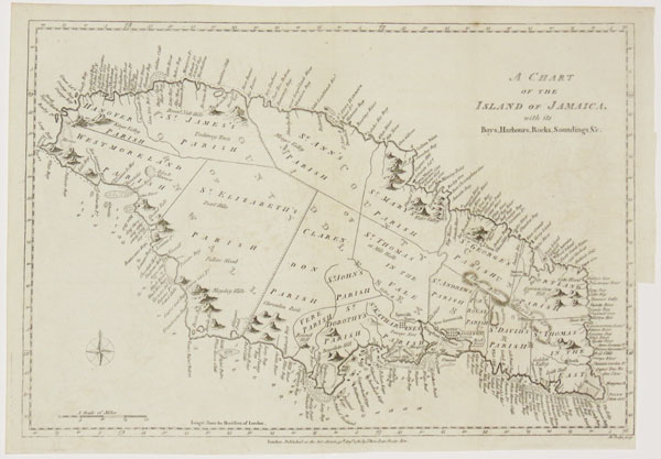
A Chart of the Island of Jamaica, with its Bays, Harbours, Rocks, Soundings &c.
Jn.o Lodge sculp.
London, Published as the Act directs, 31st August 1780, by J. Bew, Pater Noster Row.
Engraved map. Sheet 285 x 390mm (11¼ x 15½"), with 4pp. letterpress description of Jamaica. Trimmed close to neatline lower right for binding, folds.
A map of Jamaica published during the American War of Independence, which the French used as an excuse to attack British colonies in the West Indies. Although the text here relates to the economy of the island, a note states that the March issue of the 'Political Magazine' had a description of the defences.
[Ref: 43274] £175.00

View From Content.
P.H. Gosse Del.t. H & N Hanhart Imp.t.
[London: Longman & Co. 1851.]
Rare tinted lithograph. Sheet size: 95 x 140mm (3¾ x 5½"). Small repaired tear in upper egde.
Plate three from 'A Naturalist's Sojourn In Jamaica' by English naturalist Phillip Henry Gosse (1810 - 1888), published in 1851. Gosse travelled to Jamaica in 1844 and stayed for eighteen months to observe the diverse wildlife there. Upon his return he described his findings in a trilogy of books. The first two examined the island's birds, he has been hailed as the 'father of Jamaican ornithology', and the third described all the other forms of life on the island, from beetles to fruit trees. Gosse documented his work by writing it in a diary form, discussing what he encountered as his journey progressed, and providing a number of illustrations. Abbey Travel: 688.
[Ref: 37152] £95.00
(£114.00 incl.VAT)
![[Jamaica] Cave.](img-thumbnail/jpegs/37153.jpg)
[Jamaica] Cave.
P.H. Gosse Del.t. H & N Hanhart Imp.t.
[London: Longman & Co. 1851.]
Rare tinted lithograph. Sheet size: 95 x 140mm (3¾ x 5½").
Plate five from 'A Naturalist's Sojourn In Jamaica' by English naturalist Phillip Henry Gosse (1810 - 1888), published in 1851. Gosse travelled to Jamaica in 1844 and stayed for eighteen months to observe the diverse wildlife there. Upon his return he described his findings in a trilogy of books. The first two examined the island's birds, he has been hailed as the 'father of Jamaican ornithology', and the third described all the other forms of life on the island, from beetles to fruit trees. Gosse documented his work by writing it in a diary form, discussing what he encountered as his journey progressed, and providing a number of illustrations. Abbey Travel: 688.
[Ref: 37153] £95.00
(£114.00 incl.VAT)

Port Royal, Jamaica.
Pocock del. Richards sculp.
Published 31st July 1804 by J.Gold, 103 Shoe Lane, Fleet Street.
Aquatint. 130 x 220mm.
Published in the 'Naval Chronicle'.
[Ref: 4377] £90.00
(£108.00 incl.VAT)

Port Royal in Jamaica.
London, Publish'd, Dec.r 30th 1809 by J.Gold, Shoe Lane.
Engraving. 135 x 170mm, 5¼ x 6¾". Trimmed within plate top and bottom.
A chart of Port Royal harbour, published in the Naval Chronicle.
[Ref: 19997] £95.00

A View in the Island of Jamaica, of Roaring River Estate, belonging to William Beckford Esq.r near Savannah la Marr; To whom this Plate is Dedicated by his most Obliged Servant, John Boydell. No. 2.
Drawn on the Spot, & painted by George Robertson. Engraved by Thomas Vivares.
Published Mar: 25th, 1778 by Jn.o Boydell Engraver in Cheapside London.
Engraving. Sheet 400 x 550mm (15¾ x 21¾"). Trimmed within plate. Bit messy in borders.
Plate 2 of six views of Jamaica by George Robertson, of which three were his patron William Beckford's sugar plantations in Jamaica. The illegitimate nephew of Alderman Beckford, William inherited four such estates but squandered his wealth (for example employing Mozart as his son's piano teacher) and lost his holdings. He returned to London in 1776 and seems to have sold the paintings to Boydell for publishing. The John Carter Brown Library's exhibition, 'Aestheticizing the Landscape of Sugar', describes the engravings as 'the most aesthetically ambitious views of Jamaica published in the eighteenth century'.
[Ref: 52918] £520.00

A View in the Island of Jamaica, of the Bridge crossing the River Cobre near Spanish Town. Dedicated to William Beckford Esq.r of Somerley in Suffolk, by his most Obliged Servant, John Boydell. No. 6.
Drawn on the Spot & Painted by George Robertson. Engraved by Daniel Lerpiniere.
Published March 25th, 1778 by John Boydell Engraver in Cheapside London.
Mixed-method engraving. 405 x 560mm (16 x 22"). Trimmed to platemark, dedication and publisher's inscription weakly inked. Crease at bottom of image. Right hand corner in border made up.
Plate 8 of six views of Jamaica by George Robertson, of which three were his patron William Beckford's sugar plantations in Jamaica. The illegitimate nephew of Alderman Beckford, William inherited four such estates but squandered his wealth (for example employing Mozart as his son's piano teacher) and lost his holdings. He returned to London in 1776 and seems to have sold the paintings to Boydell for publishing. The John Carter Brown Library's exhibition, 'Aestheticizing the Landscape of Sugar', describes the engravings as 'the most aesthetically ambitious views of Jamaica published in the eighteenth century'.
[Ref: 52919] £320.00

Trelawney Town, the Chief Residence of the Maroons.
[Bryan Edwards; 1801.]
Rare engraving. Plate 297 x 255mm. 11¾ x 10".
The Maroons formed two distinct communities in the mountains of central Jamaica, known as cockpit country. They were composed of runaway slaves and their descendents. The word maroon derives from the Spanish cìmarron meaning wild, and maroon communities frequently settled in areas across the Caribbean that were outside the control of European colonial powers. They had a troubled relationship with British authorities. In 1730, in a treaty signed by the governor of Jamaica and Cudjoe, the Maroon leader, the Maroons land was secured in exchange for their loyalty to Britain. In the peace that followed, the Maroons were true to their word, returning runaways and helping to put down slave insurrections. Despite this, the British were always wary of the Maroons, who remained outside their control. During the revolutionary crisis of the 1790s, this fear of the Maroons resulted in Britain turning a minor confrontation into an all-out war, and many Maroons were exiled. The communities survived, however, and their descendants live in Jamaica to this day. From "The History, Civil and Commercial, of the British Colonies in the West Indies". Royal Museums of Greenwich: ZBA2523.
[Ref: 26074] £220.00
(£264.00 incl.VAT)

Trelawney Town, the Chief Residence of the Maroons.
Publish'd Sept. 25 1800, by John Stockdale, Piccadilly.
Engraving, platemark 200 x 260mm (8 x 10"). Fold as normal;
View in Trelawny Parish, Jamaica. The Maroons formed two distinct communities in the mountains of central Jamaica, known as cockpit country. The word maroon derives from the Spanish cìmarron meaning wild, and maroon communities (composed of runaway slaves and their descendants) frequently settled in areas across the Caribbean that were outside the control of European colonial powers. In 1730, in a treaty signed by the governor of Jamaica and Cudjoe, the Maroon leader, the Maroons land was secured in exchange for their loyalty to Britain. In the peace that followed, the Maroons were true to their word, returning runaways and helping to put down slave insurrections. Despite this, the British were always wary of the Maroons, who remained outside their control. During the revolutionary crisis of the 1790s, this fear of the Maroons resulted in Britain turning a minor confrontation into an all-out war, and many Maroons were exiled. The communities survived, however, and their descendants live in Jamaica to this day. Plate from the 1801 edition of 'The History, Civil and Commercial, of the British Colonies in the West Indies' (first edn. 1793) by the planter and politician Bryan Edwards (1743-1800). Edwards was bequeathed two estates in Trelawny parish, and led a distinguished political career in Jamaica. For Edwards' house 'Bryan Castle' in Trelawny parish, see ref. 37208.
[Ref: 41691] £160.00
(£192.00 incl.VAT)

Katholsk Missionär I Westindien.
Lith. tr. h. Aorah, Lundquist & C.ie
[n.d. c.1850.]
Lithograph. 223 x 310mm. 8¾ x 12¼".
The arrival of Europeans was a disaster for the native people of the islands. Most soon died from disease and mistreatment. They were replaced by white colonists and African slaves. Catholic missionaries worked to baptize the slaves and often tried to improve their treatment. Beginning in the 1600s, the British took over part of the West Indies, including the large island of Jamaica. The Church of England sent missionaries to work among the colonists and African slaves. Later, other Protestant churches also established themselves in the British West Indies.
[Ref: 21055] £140.00
(£168.00 incl.VAT)

A Plan of Martinique.
[n.d. c.1800.]
Hand-coloured engraving. Plate 138 x 164mm. 5½ x 6½". Cut close to the plate at the bottom.
Martinique, an island in the eastern Caribbean Sea. Ackermann's Repository of Arts published between 1809 and 1829 by Rudolph Ackermann, was a journal and periodical which discussed and illustrated day to day life, which also influenced English taste in fashion, architecture and literature. See Ackermann's Repository ref:17091.
[Ref: 17093] £65.00
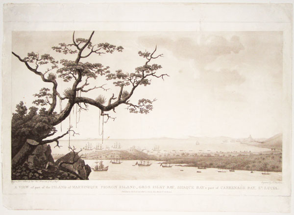
A View of part of the Island of Martinique Pigeon Island, Gros Inlet Bay, Shaque Bay & part of Careenage Bay, St. Lucia.
Drawn from Nature by Lieut. Chas. Forrest late of the 90 Reg.t. Engraved by F. Chesham.
Published as the Act directs Feb.y 15 1785, by John Walker, No. 148 Strand.
Aquatint with etching printed in sepia. 300 x 510mm (11¾ x 20"). Trimmed almost to plate at sides, faint vertical crease, some general light scuffing and soiling.
View looking south of European shipping off the island Martinique in the eastern Caribbean Sea, with a distant view of St. Lucia. A very rare print, after Lieutenant-Colonel Charles Ramus Forrest (1750 - 1827). One of 'Twelve Views of the Island of Saint Lucia ... By Lieut. Chas. Forrest; engraved by Chesham', 1784-86. Forrest was a British military officer who served in India, the West Indies, and on the staff of the Earl of Dalhousie, Governor in Chief of Canada, from 1821 to 1823. Although an accomplished amateur artist, Forrests professional performance did not live up to Dalhousies expectations and he was dismissed. He returned to England in 1823. His best known work is probably 'A Picturesque Tour along the Rivers Ganges and Jumna', 1824. British Library: 004924537.
[Ref: 45843] £580.00

A Plan of Martinique.
[n.d., c.1800.]
Engraved map with hand-colour. Plate: 140 x 160mm (5½ x 6¼").
A map of Martinique in the Caribbean showing the roads on the island.
[Ref: 46054] £110.00

Diamond Rock, Martinique.
N. Pocock delt. Wells sculp.t.
Published March 31st 1803 by J.Gold, 103 Shoe Lane.
Aquatint. 130 x 220mm.
Published in the 'Naval Chronicle'.
[Ref: 4365] £70.00
(£84.00 incl.VAT)

View of St. Louis.
Pub.d at R. Ackermann's, London, 1821.
Hand-coloured aquatint. 90 x 145mm. 3½ x 5¾". Crease along upper edge.
Fort Saint Louis is a fortress on a peninsula at Fort-de France, Martinique.
[Ref: 21021] £130.00
(£156.00 incl.VAT)

Landing Stage, Montserrat. To Bob Davis. [in pencil.]
Reynolds Beal. 1932. [signed in pencil.]
Etching. Framed. Plate: 170 x 245mm (6¾ x 9½''). Plate: 470 x 550mm (18½ x 21¾''). Unexamined out of frame.
A view of a harbour on the Caribbean island of Montserrat by American artist Reynolds Beal (1867-1951). Beal, the elder brother of the artist Gifford Beal, worked and lived in New York where he was a member of various artistic societies including the Salmagundi Club, Lotus Club, the National Academy of Design, the American Water Color Society and the Society of American Engravers. The plate is dedicated to American journalist and writer Robert H. ''Bob'' Davis (1869-1942).
[Ref: 49440] £320.00

Beach at Nevis. To Bob Davis. [in pencil.]
Reynolds Beal. 1932. [signed in pencil.]
Etching. Framed. Plate: 170 x 245mm (6¾ x 9¾''). Frame: 470 x 545mm (18½ x 21½''). Unexamined out of frame.
A view of a beach on Caribbean island of Nevis by American artist Reynolds Beal (1867-1951). Beal, the elder brother of the artist Gifford Beal, worked and lived in New York where he was a member of various artistic societies including the Salmagundi Club, Lotus Club, the National Academy of Design, the American Water Color Society and the Society of American Engravers. The plate is dedicated to American journalist and writer Robert H. ''Bob'' Davis (1869-1942).
[Ref: 49437] £320.00

A New & Exact Plan of the Harbour of Port Louis, with ye Attack on Fort St. Louis Taken by Admiral Knowles Mar:8: 1747/8.
by F. Vallnight.
London Mag: for June, 1748.
Engraving. 210 x 122mm. 8¼ x 4¾". Rust mark.
Plan with key of the attack on Port Louis, Hispaniola, by Admiral Sir Charles Knowles d.1777. Published in the London Magazine.
[Ref: 15591] £70.00
(£84.00 incl.VAT)

Mode of Training Blood Hounds. Rainsford's Account of St Domingo.
[1805]
Engraving, scarce, sheet 165 x 115mm (6½ x 4½"). Trimmed.
Plate from Marcus Rainsford's 'An Historical Account of the Black Empire of Hayti' (1805). The engraving illustrated an explanation of how European armies and the colonial militia trained guard dogs. Next to the military officer is 'a figure roughly formed as a negro in wicker work, in the body of which were contained the blood and entrails of beasts'. After long exposure as a temptation, the dogs were released to tear apart the mannequin and eat the meat inside. The dogs, thus trained, were commonly deployed to chase down runaway slaves. Rainsford (c.1750-c.1805) served in the military in the West Indies. In 1799 he visited Santo Domingo and met the rebel leader Toussaint l'Ouverture, and was subsequently arrested and condemned to death as a spy before he was reprieved and set free. Rainsford subsequently wrote accounts of his adventures and observations in the Caribbean. See Sara E. Johnson, 'The Fear of French Negroes: Transcolonial Collaboration in the Revolutionary Americas', pp.27-8.
[Ref: 41655] £140.00
(£168.00 incl.VAT)

Roseau in the West Indies.
N. Pocock delt. Bennett sculp.t.
Published 31st Dec.r. 1808 by J.Gold, 103 Shoe Lane, Fleet Street.
Aquatint. 130 x 220mm.
Published in the 'Naval Chronicle'.
[Ref: 4381] £80.00
(£96.00 incl.VAT)

Basseterre. St. Kitts. To Bob Davis. [in pencil.]
Reynolds Beal. 1932. [signed in pencil.]
Etching. Framed. Plate: 170 x 245mm (6¾ x 9½''). Frame: 465 x 550mm (18¼ x 21½''). Unexamined out of frame.
A view of Basseterre, capital of the Caribbean island of St. Kitts by American artist Reynolds Beal (1867-1951). Beal, the elder brother of the artist Gifford Beal, worked and lived in New York where he was a member of various artistic societies including the Salmagundi Club, Lotus Club, the National Academy of Design, the American Water Color Society and the Society of American Engravers. The plate is dedicated to American journalist and writer Robert H. ''Bob'' Davis (1869-1942).
[Ref: 49439] £320.00
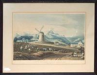
View in the Island of Saint Christopher In The Parish of Nicola Town. Proof.
Drawn by J. Johnson. Engraved by T. Fielding.
[London Published Feb. 1. 1827 by T. & G. Underwood, Fleet Street.]
Fine aquatint, printed in colours and hand finished. Framed, sight size 300 x 435mm (11¾ x 17"). Hand colour faded, framed over publication line? Unexamined out of frame.
A rare view of slaves at work in the cane fields of the Eastridge Estate on the north east side of St Christopher's, with a windmill and mountains behind. From the series 'Views of the West Indies', which was proposed to be five parts. The first two parts were published by the Underwoods in 1827, with a third by Smith & Elder in 1829, before the series was wound up. A map of Antigua and 11 plates were issued. Abbey: 678, ''a pity, for these plates were excellent''.
[Ref: 61568] £520.00

St. Kitts.
Pocock del. Medland sculp.
Publish'd 30 April, 1805 by J. Gold, 103 Shoe Lane, Fleet Street.
Aquatint with later hand colour. Sheet 140 x 235mm (5½ x 9¾").
Apparently the Battle of St Kitts, a sea battle between Britain and France in 1782, during the American Revolutionary War. Published in the 'Naval Chronicle'.
[Ref: 49543] £95.00
(£114.00 incl.VAT)

A View of Pigeon Island & part of St. Lucia, Taken March 25th 1780, at Eleven oClock AM.
Drawn from Nature by Lieut. Chas. Forrest late of the 90 Reg.t. Engraved by Fran.s Chesham.
Published as the Act directs March 10 1784, by W. Faden Corner of St Martin's Lane, Charing Cross.
Scarce aquatint with etching printed in sepia, fine 18th century watermark. 300 x 510mm (11¾ x 20"), large margins.
A view of British warships at St. Lucia, with a flag on Signal Hill on Pigeon Island (now joined to mainland by a causeway). Admiral Rodney made Pigeon Island his base, building Fort Rodney, because he could see the French navy on Martinique from Signal Hill. A month after Forrest drew this view Rodney fought the Battle of Martinique (17the April 1780). From the rare series 'Twelve Views of the Island of Saint Lucia' by Lieutenant-Colonel Charles Ramus Forrest (1750 - 1827). He was a British military officer who served in India, the West Indies, and on the staff of the Earl of Dalhousie, Governor in Chief of Canada, from 1821 to 1823. Although an accomplished amateur artist, Forrest's professional performance did not live up to Dalhousie's expectations and he was dismissed. He returned to England in 1823. His best known work is probably 'A Picturesque Tour along the Rivers Ganges and Jumna', 1824. Parker: Not in.
[Ref: 58264] £650.00

St. Lucia. Dominique, S. End.
W.S. Andrews, del. W. Spreat, Lith.
Day & Son, Lith.rs to the Queen. [London, c.1860.]
Tinted lithograph, sheet 270 x 370mm. 10½ x 14½".
Two prospects of West Indian islands: the top one shows St Lucia, centred on Castries on the N.W. coast; the bottom shows S.W. Dominica between Roseau and Scots Head. From 'Andrews's Illustrations of the West Indies'. Rare: not listed in Abbey Travel.
[Ref: 17715] £270.00
(£324.00 incl.VAT)

View of the Town of S.t Thomas, W.I.
Lith. of F. Michelin & Geo. E. Leefe. 180 Fulton S.t N.Y.
Lithograph. Sheet: 120 x 185mm (4¾ x 7¼").
A view of the town of St Thomas in the Virgin Islands published in America.
[Ref: 47373] £130.00
(£156.00 incl.VAT)

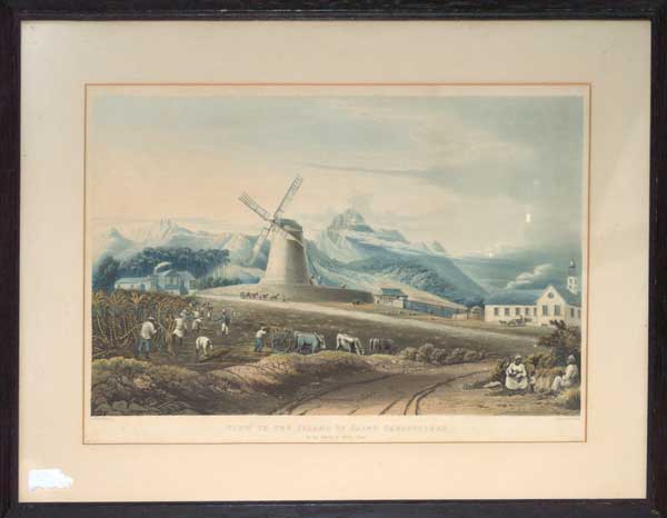
A View of the Governors Residence in the Botanic Garden _ St. Vincent.
On Stone by C. Haghe
Printed by W. Day
Lithograph on india paper with large margins, sheet 135 x 220mm (5¼ x 8½"). Toning to edges.
The St Vincent Botanic Gardens were established by Sir Robert Melville in 1765 (making them the oldest botanic gardens in the Western Hemisphere). In 1823 three acres were set aside for the construction of a house for the Colonial Governor, shown here. Plate from 'Four Years' residence in the West Indies' by Frederick William N. Bayley (1808-52), who accompanied his father (a soldier) to Barbados in the 1820s. Bayley writes in his book that 'perhaps I could not have been on a more delightful spot than the citadel at Forth Charlotte'. Not in Abbey.
[Ref: 33772] £120.00
(£144.00 incl.VAT)
![[Dominica] The Layeau Valley. From the Sea.](jpegs/53597.jpg)
![[Dominica] Government House. From the Ruins of the Old Government House.](jpegs/53598.jpg)
![[Dominica] Morne Daniole. From King's Hill.](jpegs/53599.jpg)


![[Four lithographic views of Jamaica on an album sheet.]](jpegs/53701.jpg)

![[Jamaica] Cave.](jpegs/37153.jpg)