Results 1-8 of 8
<<< Previous 1 Next >>>

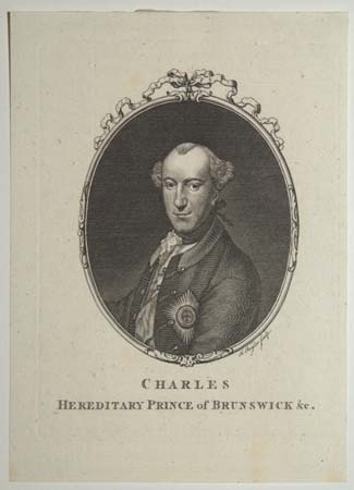
Charles Hereditary Prince of Brunswick &c.
Engraving. 130 x 100mm (5 x 4"). Trimmed almost to plate on right edge. Faint staining along the bottom margin.
Head and shoulders portrait of Charles William Ferdinand, Duke of Brunswick (1735-1806), inclined to the left and framed in an oval. He was recognised for his prowess in military command. Charles was mortally wounded at the Battle of Jena-Auerstedt against one of Napoleon's armies.
[Ref: 53877] £45.00
(£54.00 incl.VAT)
![[Top right sheet of Isaac Taylor's 'Dorset Shire'.]](img-thumbnail/jpegs/48925.jpg)
[Top right sheet of Isaac Taylor's 'Dorset Shire'.]
[Ross-on-Wye, 1765.]
Engraved map, one sheet of six. 590 x 470mm (23¼ x 18½"), very large margins. Central crease as normal. Uncut.
One sheet of the first large-scale map of Dorset. engraved by Isaac Taylor (1730-1807) from his own survey. It covers Cranborne, Blandford Forum, and Wimborne Minster in unprecedented detail, with vignettes of the 'Observatory at Horton and 'Shirborne Castle' in panels at the top. See Ref: 48926 & 48927.
[Ref: 48925] £320.00
![[Bottom right sheet of Isaac Taylor's 'Dorset Shire'.]](img-thumbnail/jpegs/48926.jpg)
[Bottom right sheet of Isaac Taylor's 'Dorset Shire'.]
[Ross-on-Wye, 1765.]
Engraved map, one sheet of six. 590 x 470mm (23¼ x 18½"), very large margins. Central crease as normal. & other central crease. Uncut.
One sheet of the first large-scale map of Dorset. engraved by Isaac Taylor (1730-1807) from his own survey. It covers Poole Harbour, Swanage, Studland, Corfe, Worth Matravers and Wareham in unprecedented detail, with the 'Characters' (key) bottom right. See: Ref 48925 & 48927
[Ref: 48926] £520.00
![[Top central sheet of Isaac Taylor's 'Dorset Shire'.]](img-thumbnail/jpegs/48927.jpg)
[Top central sheet of Isaac Taylor's 'Dorset Shire'.]
[Ross-on-Wye, 1765.]
Engraved map, one sheet of six. 590 x 470mm (23¼ x 18½"), very large margins. Central crease as normal. Uncut.
One sheet of the first large-scale map of Dorset. engraved by Isaac Taylor (1730-1807) from his own survey. It covers Shaftesbury, Sherborne, and Cerne Abbas (marking the position of the 'Giant') in unprecedented detail, with a vignette of the 'Lullworth Castle' in a panel at the top. See Ref: 48926 & 48925.
[Ref: 48927] £420.00
![[Town and Country Magazine] Frontispiece Vol VII. No 1.](img-thumbnail/jpegs/56786.jpg)
[Town and Country Magazine] Frontispiece Vol VII. No 1.
I. Taylor f.
[1775.]
Engraving. 170 x 115mm (6¾ x 4½") very large margins.
An allegorical frontispiece for the 'Town and Country Magazine', featuring classical gods, including Apollo and Cupid, around a globe. Isaac Taylor's original artwork, a pen and ink sketch with grey wash, is in the Yale Center for British Art.
[Ref: 56786] £60.00
(£72.00 incl.VAT)
![[...This Map of the County of Worcester...]](img-thumbnail/jpegs/59549.jpg)
[...This Map of the County of Worcester...]
[Drawn, engraved and published by Isaac Taylor.]
[Ross-on-Wye, 1772.]
Engraved map, one sheet [of four], with original hand colour. 530 x 515mm (21 x 20¼"), with large margins. Some wear to edges. Slight creasing in right margin.
One sheet of Isaac Taylor's monumental four-sheet map of Worcestershire, showing the south-east of the county, decorated with a scale cartouche and compass rose. Taylor (c.1720-88, not to be confused with the engraver (1730-1807), lived at 54-55 High Street, Ross-on-Wye. He surveyed down plans and five large-scale county maps: Herefordshire 1754, Hampshire 1759, Dorset 1765, Worcestershire 1772, and Gloucestershire 1777.
[Ref: 59549] £230.00
![[...This Map of the County of Worcester...]](img-thumbnail/jpegs/59552.jpg)
[...This Map of the County of Worcester...]
[Drawn, engraved and published by Isaac Taylor.]
[Ross-on-Wye, 1772.]
Engraved map, one sheet [of four], with original hand colour. 530 x 515mm (21 x 20¼"), large margins. Some wear to edges. Tear top left.
One sheet of Isaac Taylor's monumental four-sheet map of Worcestershire, showing the north-west of the county, with Kidderminster, the map's key and gazetteer. Taylor (c.1720-88, not to be confused with the engraver (1730-1807), lived at 54-55 High Street, Ross-on-Wye. He surveyed down plans and five large-scale county maps: Herefordshire 1754, Hampshire 1759, Dorset 1765, Worcestershire 1772, and Gloucestershire 1777.
[Ref: 59552] £180.00
![[...This Map of the County of Worcester...]](img-thumbnail/jpegs/59553.jpg)
[...This Map of the County of Worcester...]
[Drawn, engraved and published by Isaac Taylor.]
[Ross-on-Wye, 1772.]
Engraved map, one sheet [of four], with original hand colour. 530 x 515mm (21 x 20¼") very large margins. Some wear to edges.
One sheet of Isaac Taylor's monumental four-sheet map of Worcestershire, showing the north-east of the county, with Droitwich, Stourbridge and Dudley, also marking Edbaston and Birmingham across the border with Warwickshire. Taylor (c.1720-88, not to be confused with the engraver (1730-1807), lived at 54-55 High Street, Ross-on-Wye. He surveyed down plans and five large-scale county maps: Herefordshire 1754, Hampshire 1759, Dorset 1765, Worcestershire 1772, and Gloucestershire 1777.
[Ref: 59553] £230.00
<<< Previous 1 Next >>>
![[Top right sheet of Isaac Taylor's 'Dorset Shire'.]](jpegs/48925.jpg)
![[Bottom right sheet of Isaac Taylor's 'Dorset Shire'.]](jpegs/48926.jpg)
![[Top central sheet of Isaac Taylor's 'Dorset Shire'.]](jpegs/48927.jpg)
![[Town and Country Magazine] Frontispiece Vol VII. No 1.](jpegs/56786.jpg)
![[...This Map of the County of Worcester...]](jpegs/59549.jpg)
![[...This Map of the County of Worcester...]](jpegs/59552.jpg)
![[...This Map of the County of Worcester...]](jpegs/59553.jpg)