Results 1-20 of 20
<<< Previous 1 Next >>>
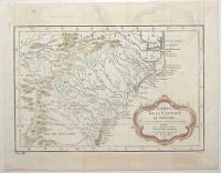
Carte de la Caroline et Georgie. Pour servir à l'Histoire Generale des Voyages.
Tirée des Auteurs Anglois par M.B. Ing. de la Marine. 1757.
[Paris: Didot Libraire, c.1757.]
Engraved map with hand colour, 18th century watermark. 200 x 300mm (8 x 11¾"). Binding folds, four pairs on worm holes in image, two near right plate mark. Offsetting.
A map of the US coastline from Albemarle Sound south to Jekyll Island (near Brunswick in Georgia). It extends inland to the Appalachians and parts of Eastern Tennessee. Published in Prevost's 'Histoire Generale des Voyages'.
[Ref: 59456] £260.00
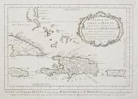
Carte de L'Isle d'Hayti, Aujour d'hui l'Espagnole, ou L'Isle de St Domingue, avec les Isles voisins... {repeated in Dutch.]
J. V. Schley direx.
[The Hague, c.1760.]
Engraved map. 245 x 345mm (9¾ x 13½") large margins. Binding folds flattened, rubbed area on right border.
A map of Hispaniola, now divided between Haiti and the Domincan Republic, with eastern Cuba and Jamaica, Puerto Rico and the Turks & Caicos Islands. Engraved by Jakob van der Schley for a Dutch edition of Prevost's 'Histoire de Voyages', which reproduced the original illustrations by Jacques-Nicolas Bellin.
[Ref: 45247] £160.00
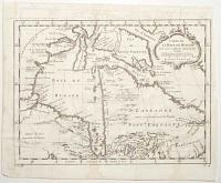
Carte de la Baye de Hudson. Pour servir à l'Histoire Generale des Voyages.
Par M. B. [Bellin] Ing.r de la Mar.e 1757.
[Paris: Didot Libraire, c.1757.]
Engraved map, 18th century watermark. 235 x 315mm (9¼ x 12½"). Narrow right margin, binding folds, slight damp staining.
A map of Hudson Bay and Newfoundland. A note in French top left states that 'the England search for a [North West] passage here but it doesn't exist'. Published in Prevost's 'Histoire Generale des Voyages'.
[Ref: 59459] £130.00
![[Hudson Bay] Carte des Parties du Nord-Ouest de l'Amerique Suivant les Voyages de Middleton et d'Ellis en 1742 et 1746.](img-thumbnail/jpegs/61381.jpg)
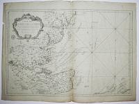
[Hudson Bay] Carte des Parties du Nord-Ouest de l'Amerique Suivant les Voyages de Middleton et d'Ellis en 1742 et 1746. Pour chercher un Passage dans la Mer du Sud.
Par M. B. [Bellin] Ing. de la Marine 1753.
[Paris: Didot Libraire, c.1753.]
Engraved map, 18th century watermark. 230 x 290mm (9 x 11½"), large margins. Folded as issued.
A map of the northern part of Hudson Bay, recording the voyages of Christopher Middleton and Henry Ellis in search of the North West Passage. Published in Prevost's 'Histoire Generale des Voyages'.
[Ref: 61381] £230.00
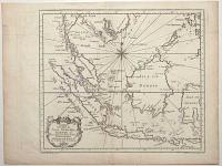
Carte des Isles de Java, Sumatra, Borneo &a. Les Détroits de la Sonde Malaca et Banca Golphe de Siam &a.
Par N. Bellin. Ing.r de la Marine.
[Paris: Didot Libraire, c.1760.]
Engraved map, 18th century watermark. 225 x 295mm (8¾ x 11½"). Binding folds.
A map of Indonesia, with the Malay Peninsula, Sumatra, Java, Borneo, the Celebes and Mindoro in the Philippines. Published in Prevost's 'Histoire Generale des Voyages'.
[Ref: 59454] £260.00
![[Map of Macau and surrounding area]](img-thumbnail/jpegs/47424.jpg)
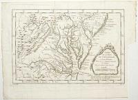
[Map of Macau and surrounding area] Carte de l'entrée de la riviere de Canton Dressée sur les Observations les plus récentes. Par N.B. Ing.r [...]
J.v. Schley direx. [c.1764]
Engraving, platemark 275 x 210mm (11 x 8"), with very large margins. Folds as normal.
Map of the port of Macau and the entrnce to the Pearl River in China. From a Dutch edition of Prevost's 'Histoire des Voyages', with copies of Jacques-Nicolas Bellin's maps.
[Ref: 47424] £160.00
![[Map of Macau]](img-thumbnail/jpegs/47417.jpg)
[Map of Macau] Plan de la Ville et du Port de Macao, Par N.B. Ing.r de la Marine [...]
J.v. Scley direx. [c.1764]
Engraving with hand-colouring, platemark 230 x 175mm (9 x 7"). Small margins.
Map of the port of Macau on the Pearl River in China. From a Dutch edition of Prevost's 'Histoire des Voyages', with copies of Jacques-Nicolas Bellin's maps.
[Ref: 47417] £140.00
![Ancien Mexico. Oud Mexico. [&] Nouveau Mexico. Nieuw Mexico.](img-thumbnail/jpegs/33708.jpg)
Ancien Mexico. Oud Mexico. [&] Nouveau Mexico. Nieuw Mexico.
J. V. Schley direx.
[The Hague, c.1760.]
Pair of engravings. Each c. 210 x 290mm (8¼ x 11½"). Binding folds flattened.
Pair of views of the development of Mexico City. The first shows the early Spanish settlement, built after the Conquistadors had destroyed the Aztec city of Tenochtitlan in 1521. The second is a view of the city from the mid-1600s, taken from Montanus, showing the city after the lake had been drained after the terrible floods of 1621. Both views were engraved by Jakob van der Schley for a Dutch edition of Prevost's 'Histoire de Voyages', which reproduced the original illustrations by Jacques-Nicolas Bellin.
[Ref: 33708] £260.00
(£312.00 incl.VAT)
view all images for this item
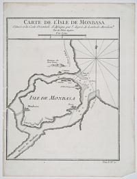
Carte de l'Isle de Monbasa. Située a la Coste Orientale d'Afrique par 5 degrés de Latitude Meridion.le Tiré du Pilote Anglois. Une Lieue.
Tom.V.N.o 10.
[Jacques Nicolas Bellin, n.d. c.1760.]
Copper engraving. 254 x 190mm (10 x 7½"). Cut into the platemark along left-hand edge, and visible worm holes.
Mombasa Island is a coral outcrop located on Kenya's coast on the Indian Ocean.
[Ref: 18005] £120.00
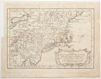
Carte de la Nouvelle Angleterre Nouvelle Yorck et Pensilvanie. Pour servir à l'Histoire Generale des Voyages.
Par M. B. [Bellin] Ing. de la Mar.e 1757.
[Paris: Didot Libraire, c.1757.]
Engraved map, 18th century watermark. 220 x 310mm (8½ x 12¼"). Trimmed to plate upper left by binder, folds with a small tear, 8 worm holes in image.
A map of the Eastern Seaboard from Delaware Bay north to Penobscot, and west to Lake Erie. Published in Prevost's 'Histoire Generale des Voyages'.
[Ref: 59458] £250.00
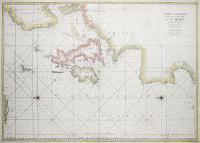
Carte Generale des Costes de L'Europe sur L'Ocean Comprises depuis Dronthem en Norwege Jusques au Detroit de Gibraltar.
[Paris: Jacques Nicolas Bellin for the the Depot de la Marine, c.1750.]
Coloured engraving. 610 x 860mm. Repairs to centrefold.
A large sea chart of Northern Europe from Norway to the Straits of Gibraltar. Originally published by Jaillot in the monumental sea atlas, the 'Neptune François', 1693.
[Ref: 602] £480.00
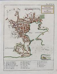
Plan des Ville et Citadelle de Plymouth.
[by Jacques Nicolas Bellin.]
[Paris, 1764.]
Engraved map with hand colour. 235 x 185mm (9¼ x 7¼"). Very large margins.
A plan of Plymouth, showing the bastions of the Citadel, published in the 'Petit Atlas Maritime'.
[Ref: 38777] £130.00
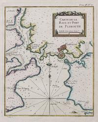
Carte de la Baye et Port de Plimouth.
[by Jacques Nicolas Bellin.]
[Paris, 1764.]
Engraved chart with hand colour. 230 x 185mm (9 x 7¼"). Very large margins.
A chart of Plymouth Sound, marking 'Plimouth' and Saltash, published in the 'Petit Atlas Maritime'.
[Ref: 38779] £130.00
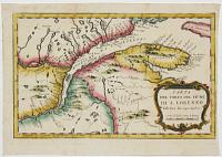
Carta del Corso del Flume di S. Lorenzo dalla foce fin sopra Quebec.
[after Jacques Nicolas Bellin.]
[Italian, c.1770.]
Engaved map with hand colour. 210 x 310mm (8¼ x 12¼").
A copy of Bellin's 1757 map of the mouth of the St Lawrence River, showing from Anticosti Island to just west of Quebec, from an Italian edition of Prevost's 'Histoire'. Originally published at the beginning of the Seven Years' War (1756-63), two years before Quebec fell to the English.
[Ref: 37065] £120.00
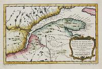
Carte du Cours du Fleuve de St Laurent Depuis son Embouchure jusqu'au dessus de Quebec. Pour servir à l'Histoire Générale des Voyages.
Par M.B. Ing. de la M.e 1757.
[Paris: Didot Libraire, c.1760.]
Engraved map with fine hand colour. 210 x 310mm (8¼ x 12¼"). Very large margins.
Map of the mouth of the St Lawrence River, showing from Anticosti Island to just west of Quebec, engraved by Jacques Nicolas Bellin for Prevost's 'Histoire'. The Seven Years' War (1756-63) had already started: two years later Quebec fell to the English.
[Ref: 37064] £140.00
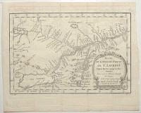
Carte du Cours du Fleuve de St Laurent Depuis Quebec jusqu'au Lac Ontarion. Pour servir à l'Histoire Générale des Voyages.
Par M.B. [Bellin] Ing. de la M.e 1757.
[Paris: Didot Libraire, c.1757.]
Engraved map, 18th century watermark. 210 x 310mm (8¼ x 12¼"). Binding folds, faint ink offset.
Map of the St Lawrence River, showing from Lake Ontario west to Quebec, with Montral and Lake Champelain. It was drawn in 1757 by Jacques Nicolas Bellin for Prevost's 'Histoire'. The Seven Years' War (1756-63) had already started: two years later Quebec fell to the English.
[Ref: 59453] £140.00
Carte des Entrées de la Tamise...
Par le S. Bellin Ingenieur de la Marine.
[Paris] MDCCLXIX [1769].
Large format engraved chart. 595 x 890mm (23½ x 35". Very large margins.
A detailed chart of the Thames Estuary, showing the coastline from Orford Ness south to Hythe, and the Thames up to London. Unusually for a chart, the main roads of Essex and Kent are also shown.
[Ref: 39402] £480.00
Carte de la Baye de Chesapeack et Pays Voisins. Pour servir à l'Histoire Generale des Voyages. Tirée des meilleures Cartes Angloises.
[Nicolas Bellin.]
[Paris: Didot Libraire, c.1757.]
Engraved map. 210 x 305mm (8¼ x 12"). Trimmed to plate lower right by binder, folds, two worm holes in image.
A map of the environs of Chesapeake Bay, with Virginia, Maryland and part of New Jersey. Published in Prevost's 'Histoire Generale des Voyages'.
[Ref: 59457] £260.00
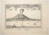
Vue De Ternate. Suppl, au Tome VIII. N.o 4.
[Jacques Nicolas Bellin]
[n.d., c1750]
Engraving, 18th century watermark; 250 x 355mm (10 x 14"), very large margins. Flattened creases where previously bound.
Depiction of Gamalama erupting in the early 1700s with a Portuguese fort shown. Made by Jacques Nicolas Bellin (1703 - 1772) for Antoine-François Prevost's (1697-1763) 20 volume edition of 'L`Histoire Generale des Voyages' published by Pierre de Hondt, The Hague between 1747 - 1780. Gamalama is a near-conical stratovolcano that comprises the entire Ternate island in Indonesia.
[Ref: 57090] £140.00
(£168.00 incl.VAT)
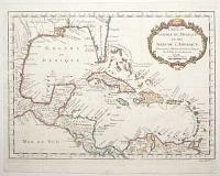
Carte du Golphe du Mexique et des Isles de l'Amerique. Pour servir à l'Histoire Generale des Voyages.
Par M. Bellin Ing.r de la Mar.e 1754.
[Paris: Didot Libraire, c.1757.]
Engraved map with hand colour, 18th century watermark; 290 x 390mm (11½ x 15¼"). Narrow right margin, binding folds, 16 worm holes.
A map of the West Indies and Gulf of Mexico. It marks the mythical island of Bermeja off Yucatan, belief in which lasted until quite recently but not found in a survey in 2009. A current conspiracy theory in Mexico claims that the Central Intelligence Agency destroyed the island to expand the economic zone allotted to the United States. Published in Prevost's 'Histoire Generale des Voyages'.
[Ref: 59460] £480.00
<<< Previous 1 Next >>>


![[Hudson Bay] Carte des Parties du Nord-Ouest de l'Amerique Suivant les Voyages de Middleton et d'Ellis en 1742 et 1746.](jpegs/61381.jpg)

![[Map of Macau and surrounding area]](jpegs/47424.jpg)
![[Map of Macau]](jpegs/47417.jpg)
![Ancien Mexico. Oud Mexico. [&] Nouveau Mexico. Nieuw Mexico.](jpegs/33708.jpg)


