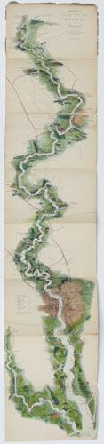
Tombleson's Panoramic Map of the River Thames from its Source to the Sea; Exhibiting the Picturesque Scenery, and Principal Objects of Interest on its Banks, with the Distances from London Bridge, &c. Also Panoramic Map of the River Medway. Engraved on Steel and Beautifully Coloured, on a sheet Four Feet in Length.
London: James Reynolds & Sons, 174, Strand. [n.d., 1876.] Original printed wrapper, advert pasted on inside front cover; folded steel-engraved map with chromolithographic colour, sheet 1285 x 255mm (50½ x 10"). Wrappers loose and distressed, splits in folds of map. Some pencil annotations. A later edition of the famous 'bird's-eye' map of the Thames, showing from the source in Gloucestershire to the North Sea. Originally published as the index map to William Tombleson's ''Tomblesons Views of the Thames and Medway'' (1833-4), the map was so popular that it was sold separately well into the 20th century. This version has been updated to show the railways.
[Ref: 50442] £750.00
view all images for this item