Results 1-1 of 1
<<< Previous 1 Next >>>
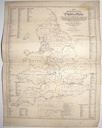
An Ecclesiastical Map of England and Wales Shewing the Position of the Catholic Churches, Chapels, Colleges, Missions, & Relgious Houses, With the Boundaries of the Archdiocese and the Diocese, With a Plan of London Shewing the Position of the Catholic Churches &c. Together With a List of the Towns in which Catholic Churches are Established. 1851.
Designed by Daniel Grant. Lithographed by Daniel Grant & Co, 75, Fleet Street.
Sold by Charles Dolman, 61 New Bond St & 48a Paternoster Row.
Scarce lithographic map. Sheet 750 x 570mm (29½ x 22½"). Creasing and surface soiling, pinholes in corners, laid on linen.
A map of the Catholic churches and chapels in England and Wales. From the Berkeley Collection, Spetchley Park.
[Ref: 54974] £500.00
<<< Previous 1 Next >>>
