Results 1-4 of 4
<<< Previous 1 Next >>>
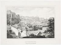
Luxembourg. Vue prise de la porte Thionville.
[n.d., c.1850.]
Lithograph, rare. Sheet: 320 x 235mm (12½ x 9¼").
A view of the city of Luxembourg showing the city walls and gate of Thionville.
[Ref: 42484] £180.00
(£216.00 incl.VAT)
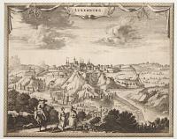
Luxemburg.
F. de Wit excudit. [n.d., c.1680.]
Etching, 17th century watermark. Sheet 220 x 275mm (8¾ x 10¾"). Trimmed to printed border.
A prospect of the town, showing the defences.
[Ref: 54711] £280.00
(£336.00 incl.VAT)
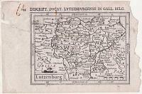
Lutzenburg.
[engraved by Jodocus Hondius II.]
[Amsterdam, c.1616.]
Engraved map. 95 x 135mm (3¾ x 5¼"), with letterpress sur-title. Repaired tear, right margin ragged, rust stains, laid on album paper.
A miniature map of Luxembourg, engraved by Jodocus Hondius II for the the 'Tabularum Geographicarum' atlas, with a text by Petrus Bertius. The is the second plate used by Bertius, replacing one engraved by Pieter van den Keere. It is recognisable by having wider borders and longitude & latitude scales.
[Ref: 59896] £130.00
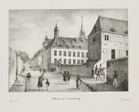
Athénée de Luxembourg.
Bertrand del Lith. de Jobard.
[n.d., c.1830.]
Lithograph, printed area 160 x 205mm (6¼ x 8").
The Athénée de Luxembourg, a high school situated in Luxembourg City, founded by Jesuits in 1603 and still in existence, although its location has changed. Originally next to Notre Dame cathedral in the Ville Haute quarter of the city, after World War II it moved to a new building in the Hollerich quarter. The old site is now occupied by Luxembourg's National Library.
[Ref: 43439] £90.00
(£108.00 incl.VAT)
<<< Previous 1 Next >>>


