Results 1-6 of 6
<<< Previous 1 Next >>>
![Auszug aus einer See-Charte die Andreas Bianco im I[ahr] 1436 zu Venedig verfertigte...](img-thumbnail/jpegs/53128.jpg)
Auszug aus einer See-Charte die Andreas Bianco im I[ahr] 1436 zu Venedig verfertigte... Auszug aus einer Charte die Fr. Picigano im I[ahr] 1367 zu Venedig verfertigte...
A.G. Ephem 1807. 10. stk.
Weimar, im Verlag des geograph. Instituts, 1807.
Engraved map. 180 x 230mm (7 x 9"). Folds as issued.
Two facsimiles of Venetian charts of the 15th & 16th centuries, showing the Atlantic before the known discovery of America, The presence of 'Y.a d'Antilla', a large island west of Madeira, is often used to argue that the Portuguese discovered America before Colombus.
[Ref: 53128] £140.00
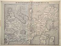
Europa das ein drittheil der erden / nach gelegenheit unsern zeiten.
[Basle, Heinrich Petri, c.1550.]
Woodcut. Sheet 282 x 375mm (11 x 14¾"). Margin bottom left restored, tape stains in edges. Evidence of cracks in the woodblock.
Munster's famous upside-down map of Europe, although omitting most of Scandinavia, Scotland and half of Ireland. Despite the strange orientation (a German convention to align maps with the solar compass) it is the first map of the continent not based on Ptolemy. The map was first used in Munster's edition of Ptolemy's 'Geographia' in 1540 and also appeared in his 'Cosmographia'; the cracks in the woodblock first appeared in 1545. A new, similar block was used from 1571-2 until 1578, when a new map, copied from Ortelius, was introduced.
[Ref: 55504] £990.00
view all images for this item
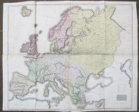
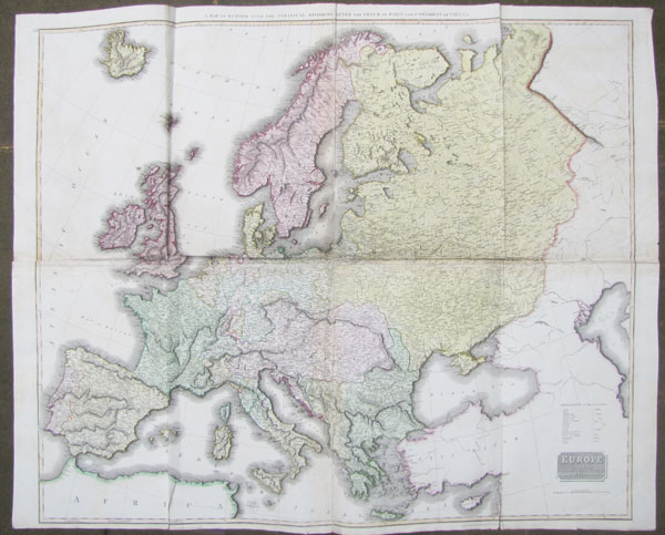
Europe after the Congress of Vienna. A Map of Europe with the Political Divisions after the Peace of Paris and the Congress of Vienna.
Drawn and Engraved for Thomson's New General Atlas. [Edinburgh, c.1823.]
Engraved map on four sheets conjoined, fine original colour. Total 1055 x 1310mm (41½ x 51"), on Whatman paper watermarked 1823. Tears at folds.
A wall map of Europe as divided up by the Congress of Vienna, 1815, at the close of the Napoleonioc Wars. While British gains were outside Europe, the gains of Russia, Prussia and Austria were confirmed, to the detriment of Poland, Saxony, Pomerania. Also the neutrality of Switzerland was guaranteed and the slave trade condemned.
[Ref: 26797] £280.00
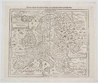
Europa nach Gelegenheit unserer Zeit New Beschrieben.
[Basle: c.1588.]
Woodcut. Printed area 320 x 360mm (12½ x 14"). Slight creasing.
A woodcut map of Europe, copied from Ortelius's map of 1570, replacing the famous upside-down map of Europe in editions of Munster's 'Cosmographia' from 1588. Sebastian Münster (1488-1552) was a Christian Hebraist scholar as well as a cartographer and cosmographer. His 'Cosmographia', first published in 1544, is the earliest German description of the world.
[Ref: 30680] £280.00
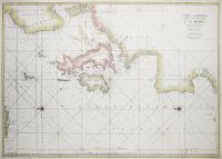
![[Untitled chart comprising of 30 Mediterranean ports & harbours.]](img-thumbnail/jpegs/16267.jpg)
[Untitled chart comprising of 30 Mediterranean ports & harbours.]
[Amsterdam, Johannes van Keulen, c.1730.]
Very scarce Engraving. 520 x 620mm, 20½ x 24½". Remargined on both sides.
A rare chart by the leading Dutch chart publishers for 150 years: it shows details of ports and harbours in Europe, Africa and Asia. They are: Porto Tanger; Porto Toulon; d'Eylanden van Eres; Porto Taranto; Porto Galipoli; Porto Brundisi; Porto de Cara-Busa; Porto Canea; Porto Zuda; Porto Andrea; I.Milo; Porto Nio; Porto Nixia; Porto Ziva; I. Delis; Eres; Porto Bona; Porto Trapano; Porto S. Pedro; Porto Serigo; Porto S. Nicolo in I. Serigo; Porto Candia; I. Stantea; Porto Spina Longa; Porto Paris; Porto Trio; Porto de Aula; Selue inde Golf van Narbona; Porto Gero in I.Metelino; Tripoli.
[Ref: 16267] £750.00
Carte Generale des Costes de L'Europe sur L'Ocean Comprises depuis Dronthem en Norwege Jusques au Detroit de Gibraltar.
[Paris: Jacques Nicolas Bellin for the the Depot de la Marine, c.1750.]
Coloured engraving. 610 x 860mm. Repairs to centrefold.
A large sea chart of Northern Europe from Norway to the Straits of Gibraltar. Originally published by Jaillot in the monumental sea atlas, the 'Neptune François', 1693.
[Ref: 602] £480.00
<<< Previous 1 Next >>>
![Auszug aus einer See-Charte die Andreas Bianco im I[ahr] 1436 zu Venedig verfertigte...](jpegs/53128.jpg)


![[Untitled chart comprising of 30 Mediterranean ports & harbours.]](jpegs/16267.jpg)
