Catalogue: England
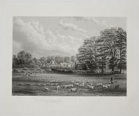
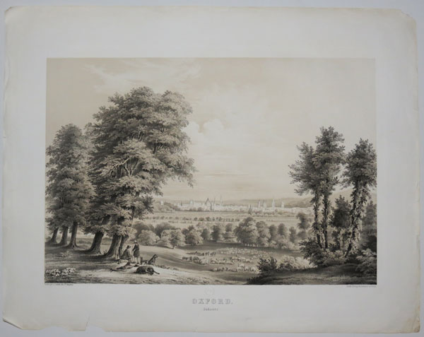
View in the Parks, Oxford, Looking South. Taken in the year, 1866.
[Le Keux.]
Mint etching, on india. Plate: 410 x 330mm (16 x 13") very large margins.
A view of the University Parks which lies to the northeast of the city. Groups of women and children can be seen walking and conversing while a shepherd and his dog are shown watching their sheep.
[Ref: 40619] £160.00
(£192.00 incl.VAT)
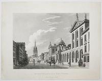
Queens College from the High Street.
Published Feb. 27th 1802 by T.Malton.
Aquatint. Sheet 315 x 400mm (12¼ x 15¾").
A good view of Oxford High Street.
[Ref: 48129] £190.00
(£228.00 incl.VAT)
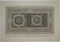
Pavimentum hoc Tessellatum Elegantiss: Stunsfeldiae prope Woodstochiam in Agro Oxoniensi repertum est. This Tessellated Pavement, discover'd at Stunsfield near Woodstock in Oxfordshire A.no D.ni MDCCXII. A most Exquisite Work of the Antient Romans, composed with great variety of Small Tesserae of Beautiful Colours & Summetry, esteem'd to be the most Elegant Piece of Antiquity of the Kind found in Great Britain. When first open'd it was seen by Multitudes of Curious Persons, and some Learned Antiquaries have employ'd their Skill to trace out its Original Use. Now only remains this Shade, preserv'd first Care of Tho. Hearne M.A. of Oxford, and lastly by G. Vertue Member of the Society of Antiquaries London. 35 feet by 20.
[T. Hearne. G. Vertue.]
[1712.]
Copper engraving. Plate 292 x 470mm. 11½ x 18½".
A drawing of the a tessellated pavement found at the Roman Villa at Stonesfield, Oxfordshire in 1712. Ex Collection: Norman Blackburn.
[Ref: 19816] £180.00
(£216.00 incl.VAT)
![[St Giles, Oxford] Hanc Ecclesiæ D. Aegidii in Suburbiis Civ. Oxon.](img-thumbnail/jpegs/42013.jpg)
[St Giles, Oxford] Hanc Ecclesiæ D. Aegidii in Suburbiis Civ. Oxon. (ut creditur Normannorum tempore) certe ante 1189 ult. R. Hen. aedificatae, faciem Austrtalem in aere excudi jussit Ric. Rawlinson LLD Oxon. R. & AT. S.S. suis sumptibus A.D> MDCCLIV.
[Engraved by George Vertue?]
[1754.]
Engraving. 210 x 250mm (8¼ x 9¾"); very large margins. Some slight soiling.
St. Giles' Church, Oxford, completed 1120 but not consecrated until 1200.
[Ref: 42013] £160.00
(£192.00 incl.VAT)
![[St Mary the Virgin, Oxford.] [No.52]](img-thumbnail/jpegs/27690.jpg)
[St Mary the Virgin, Oxford.] [No.52]
Arthur Spencer [pencil signature.]
[n.d. c.1920.]
Etching. Plate 198 x 140mm. 7¾ x 5½".
The University Church of St Mary the Virgin, Oxford. The south porch, seen here, was built in 1637 and designed by Nicholas Stone, master mason to Charles I. It is a highly eccentric baroque porch with spiral columns supporting a curly pediment framing a small niche with a statue of the Virgin and Child, underneath a gothic fan vault.
[Ref: 27690] £35.00
(£42.00 incl.VAT)
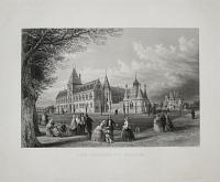
The University Museum.
Drawn & Engraved by J.H.Le Keux.
Published by J.H. Parker, Oxford, Nov.r. 1st. 1859.
Mint etching. Plate: 400 x 340mm (15¾ x 13½"), with very large margins.
A view of the Oxford University Museum of Natural History which was completed in 1861 after a neo-gothic design by Deane and Woodward.
[Ref: 40623] £260.00
(£312.00 incl.VAT)

Oxford. Südseite.
N.d. Nat.gez.v. C. Rundt, lith.v.F. Tempeltei.
Druck d. Königl.lith Instituts zu Berlin. [n.d. c.1846.]
Tinted lithograph, scarce with very large margins. Blindstamp centre title area: CR. 514 x 666mm. 20¼ x 26¼".
A wonderful view of Oxford, with the dome of the Radcliffe Camera, and the spires and high roofs of King's College, All Saints Church and other colleges of Oxford University; shepherds with their dogs sat in the near foreground with their flocks of sheep in the middleground. From Carl Rundt's "Views of the most picturesque Colleges in the University of Oxford" which was published in Berlin in two parts with five lithographed plates and four pages of discriptive text in English and German to each part and with a note recommending Ingram's Memorials of Oxford.
[Ref: 27507] £720.00
![[An Oxfordshire Lane.]](img-thumbnail/jpegs/61183.jpg)
[An Oxfordshire Lane.]
YM [John Mallows Youngman]
[n.d.c. 1899]
Etching, plate 215 x 160mm (8½ x 6¼"), with small margins. Some creasing outside image. Paper toned. Abrasions at very top of image. Messy.
A country scene in Oxfordshire. Two women stand outside a building in a stream. A girl scavenges the water. A church can be seen in the background. John Mallows Youngman (1817-99) painter, etcher and father of British painter Annie Mary Youngman (1859 1919).
[Ref: 61183] £50.00
(£60.00 incl.VAT)
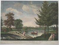
A View from the West Side of the Island in the Garden of the Hon.ble Charles Hamilton Esq.r at Painshill near Cobham in Surry.
W. Woollett del. et sculp.
Printed for Robert Sayer in Fleet Street, John Bowles in Cornhil, Carington Bowles in St.Pauls Church Yard, John Boydell in Cheapside, and Henry Parker in Cornhill [n.d., 1760].
Coloured engraving. Sheet 355 x 480mm (14 x 19"). Trimmed to image on three sides.
A view from Grotto Island with the Chinese Bridge in the foreground, with a view across the lake, at Painshill Park, Surrey. A group is out on the water in a small hand-powered paddle-driven boat. Designed and created between 1738-73 by Charles Hamilton MP, the gardens moved away from geometric formality to a new naturalistic style. It is now regarded as one of the finest remaining examples of an 18th century English landscape park. Fagan 38, II.
[Ref: 58723] £350.00
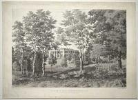
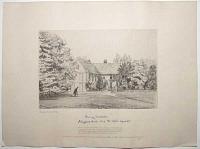
Papworth Hall, Cambridgeshire. The Seat of Cha.s Madryll Cheere Esq.r M.P.
On Stone by H. Walton, from a Sketch by Sam.l Skinner Esq.r. Printed by C. Hullmandel.
[n.d., c.1820.]
Scarce lithograph on chine collé. 330 x 430mm (13 x 17"). A little creasing and soiling on edges.
Papworth Hall at Papworth Everard, Cambridgeshire, built 1809-13 by George Byfield (1756-1813), for Charles Madryll Cheere (d.1825). In 1918 the hall was bought by the Cambridgeshire Tuberculosis Colony, a self-supporting colony where TB sufferers live and work, which developed into the Papworth Hospital.
[Ref: 56611] £320.00

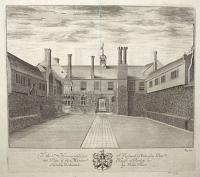
Parkhurst Prison for Juvenile Offenders, Isle of Wight. The Lower Prison. To George Hall Esq. The Governor of the Prison, This View is by Permission Most Respectfully Dedicated by the Publishers.
J. Griffiths. del. Day & Son Lith.rs to the Queen.
Published by Snooke & Upward, Newport, Isle of Wight [n.d., c.1840].
Rare tinted lithograph with hand colour. Sheet 355 x 490mm (14 x 19¼"). Very small repaired hole.
Parkhurst was originally a military hospital and children's asylum but by 1838 it had become a prison for children. George Hall, the prison governor to whom this print is dedicated, had been Private Secretary to the Governor of South Australia George Gawler, before returning to England. An early advocate of rehabilitation of young offenders, he started the 'Parkhurst Apprentices', a scheme to send his charges to the colonies to learn a trade. Between 1842 and 1852 nearly 1500 boys aged from twelve to eighteen were transported to Australia and New Zealand from Parkhurst Prison. Reputedly hung at Governor's Office, Parkhurst Prison, until 1995. From the Airlie collection, Cortachy Castle.
[Ref: 57662] £360.00

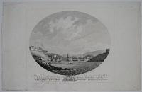
Pluto's Hall, Peak Cavern. Derbyshire.
Drawn Printed and Published by G. Rowe. Cheltenham.
[n.d., c.1839.]
Lithograph. Sheet: 230 x 295mm (9 x 11¾") large margins.
A view of a cavern in the cave system in the Peak District called Peak Cavern.
[Ref: 47241] £65.00
(£78.00 incl.VAT)
![[Pembroke Gardens] An Exact Survey of the Beautiful & Magnificent](img-thumbnail/jpegs/61711.jpg)
[Pembroke Gardens] An Exact Survey of the Beautiful & Magnificent House Garden & Park of the Right Hon.ble the Earl of Pembroke, With the Ancient Town of Wilton 3 Miles from Salisbury by John Rocque Chorographer to his Royal Highness The Prince of Wales.
Published according to Act of Parliament. Price 2.s 6.d. [1754]
Very rare engraved plan, 18th century watermark; plate 350 x 545mm (13¾ x 21½"), with large margins. Central fold.
Plan of the gardens and grounds at Wilton; the house towards the bottom with more formal gardens and large fish pond to the right, looking out towards the River Nader, and park land beyond; with inset views of the great bridge, the house itself, the arcade, and the porter's lodge on the left, and at top a further view of the bridge from the north. Below on left a plan of the ground floor on a scroll.
[Ref: 61711] £650.00
![[Pendley Manor] To the Honourable S.r Richard Anderson Bar:t this Plate of the Mannor House of Penley is Humbly Dedicated by John Oliver.](img-thumbnail/jpegs/62543.jpg)
[Pendley Manor] To the Honourable S.r Richard Anderson Bar:t this Plate of the Mannor House of Penley is Humbly Dedicated by John Oliver. Pag. 594.
[London: Benjamin Griffin et al, 1700.]
Engraving. 285 x 325mm (11¼ x 12¾") very large margins.
A view of the original Pendley Manor, near Tring, burned down in 1835. From Sir Henry Chauncy's 'Historical Antiquities of Hertfordshire'.
[Ref: 62543] £130.00
(£156.00 incl.VAT)
To the Honourable S.r Richard Anderson Bar;t this Plate of the Mannor House of Penley is Pa. 594
Humbly Dedicated by John Oliver
[Sir Henry Chauncy c.1700]
Engraving plate 285 x 375mm (11¼ x 14¾") Centre fold as issued. Some creasing. A few tears to marins. Slight ink offset.
Published for the first edition of Sir Henry Chauncy's (1632 - 1719) Historical Antiquities of Hertfordshire 1700. he manor of Pendley pre-dates the Norman Conquest of 1066, after which it was confiscated by William the Conqueror and passed to his brother-in-law, Robert, Count of Mortain (c. 1031-c.1095), and a later owner was John de Angle, an early Member of Parliament. In 1440 Sir Robert Whittingham (or Whytingham) and his wife Agnes received a grant of free warren from King Henry VI at Pendley manor; he enclosed 200 acres and tore down the buildings on the land, returning the estate to pasture. He built a manor house at the western end of the now-demolished town as a double cloistered courtyard as well as building a Chapel. On the accession of Edward IV (1442 1483) he granted Pendley manor to George Neville, Bishop of Exeter in 1461 which then passed on to the Verney family through marriage. The Verney family lived at the medieval manor for the next 150 years, until it was passed on to the Anderson family. Sir Richard Anderson, 2nd Baronet (c. 16351699) owned the Penley estate when the print was made.
[Ref: 56224] £95.00
(£114.00 incl.VAT)
![[Penshurst.]](img-thumbnail/jpegs/18622.jpg)
[Penshurst.]
Cecil Aldin [pencil signature.]
[n.d., c.1910.]
Etching, signed, from a limited edition numbered '91/100' in pencil lower left. 300 x 210mm, 11¾ x 8¼". A fine impression.
A scene at Penshurst, a village in the Sevenoaks district of Kent: an elderly woman and terrier dog approaching a gatehouse walkway with a distant view of a church. The village grew up around Penshurst Place, the ancestral home of the Sidney family. Cecil Charles Windsor Aldin (1870 - 1935), artist and illustrator, was born in Slough, the son of a builder, and studied at the South Kensington school of Art. He worked as a comic illustrator in the 1890's before achieving great success as a sporting artist. He retired to Majorca in 1930.
[Ref: 18622] £380.00
A View of Penshurst Place in the County of Kent. This plate was engraved in the Year 1747, ny Mr George Vertue, for Will.m Perry, Esq. And is now presented to this work by Mrs Elizabeth Perry his Widow, The only remaining Heir of the Noble Family of Sidney, & the Present Owner of this Seat.
[after Benjamin Dry.]
[London: c.1760.]
Coloured engraving with small margins. 440 x 560mm (17¼ x 22"). Binding folds flattened.
A bird's-eye view of the fortified Penshurst Place near Tonbridge in Kent, the ancestral home of the Sidney family (their etched crest is at centre of the inscription). Originally published in 1747 this example was published after William Perry's death in 1757, with the title re-engraved and Dry's inscription dropped.
[Ref: 30839] £290.00
(£348.00 incl.VAT)

Penzance, Cornwall.
Drawn & Engraved by Will.m Daniell.
Published by W. Daniell, Russell Place, Fitzroy Square, London May 20. 1825.
Aquatint with fine original hand colour. 230 x 300mm (9 x 12"), with large margins.
A view of the port town of Penzance. From William Daniell's 'A Voyage Round Great Britain', a series of 308 aquatints published in eight volumes between 1814-1825, described by R.V. Tooley as 'the most important colour plate book on British Topography'. Abbey: Scenery, 16; Tooley: Books with Coloured Plates 177.
[Ref: 47144] £240.00
(£288.00 incl.VAT)
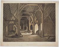
The Old Tithe Barn, Borobury, Peterborough.
Drawn & Lith.ed by Charles Moore. Day & Haghe Lith.rs to the Queen.
[n.d., c.1840.]
Tinted lithograph, scarce. Sheet 315 x 415mm (12¼ x 16¼") Some wear in margins; bit dusty.
The interior of Peterborough Abbey's tithe barn, built in the 13th century for the original abbey. In 1898 Rev. W.D. Sweeting wrote: "Until a very few years ago there was a mediaeval building at Peterborough of the greatest interest. This was the old Tithe Barn of the Abbey, situated in the Manor of Boroughbury, on the Lincoln Road. It was much the finest in the kingdom. Unhappily the ''enterprising builder'' has obtained possession of it, and it has been pulled down, the materials, all Barnack stone, having been employed in building houses. It was of good thirteenth century work, and in perfect condition. On the east side were two large porches, by which a waggon fully laden could enter the barn. The roof was supported by very massive timbers rising from the ground, the whole arrangement resembling a wooden church with aisles". Sweeting: The Cathedral Church of Peterborough.
[Ref: 43290] £240.00
(£288.00 incl.VAT)
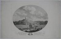
![[Original sketch for Dugdales' England & Wales.] Petworth House, Sussex. Seat of the Earl of Egremont.](img-thumbnail/jpegs/60265.jpg)
[Original sketch for Dugdales' England & Wales.] Petworth House, Sussex. Seat of the Earl of Egremont.
[Thomas Hosmer Shepherd]
[n.d., c.1838.]
Colour wash sketch. Sheet 135 x 190mm (5¼ x 7½"). Mounted on album paper at corners.
A view of the west façade of Petworth House, facing the lake. This is the original sketch for the engraving published in ''Curiosities of Great Britain: England and Wales Delineated'', by Thomas Dugdale, published by John Tallis in parts from 1838.
[Ref: 60265] £250.00
(£300.00 incl.VAT)
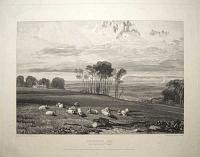
Pevensey Bay, from Crowhurst Park. Proof.
Drawn by J.M.W. Turner, R.A. Engraved by W.B. Cooke.
London, Published March 1. 1819, by John Murray, Albermarle Street, and W.B. Cooke, 13 Judd Place East, New Road.
Engraving. 255 x 330mm (10 x 13") very large margins. Small area of surface abrasion in inscription area.
A view looking across fields towards Beachy Head. From the series ''Views in Sussex'. Rawlinson 132, second published state.
[Ref: 56599] £120.00
(£144.00 incl.VAT)
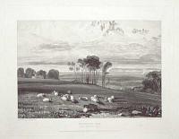
Pevensey Bay, from Crowhurst Park. Proof.
Drawn by J.M.W. Turner, R.A. Engraved by W.B. Cooke.
London, Published March 1. 1819, by John Murray, Albermarle Street, and W.B. Cooke, 13 Judd Place East, New Road.
Engraving on chine colle. 255 x 330mm (10 x 13"), with very large margins. Some light creasing on india paper.
A view looking across fields towards Beachy Head. From the series ''Views in Sussex'. Rawlinson 132, state II of III.
[Ref: 60601] £240.00
(£288.00 incl.VAT)
![[Piel Castle] Peel Castle, Lancashire.](img-thumbnail/jpegs/33896.jpg)
[Piel Castle] Peel Castle, Lancashire.
Drawn & Engraved by Will.m Daniell.
Published by Mess.rs. Longman & Co. Paternoster Row & W. Daniell, Cleveland S.t., Fitzroy Square, London, March 1. 1816.
Coloured aquatint with large margins. 300 x 230mm (12" x 9"). Slightly offset.
View across the bay to the ruins of Piel Castle, on Piel Island, one of the Islands of Furness. Several boats sail across the foreground whilst a group of figures gather around a rowing boat. Masts and buildings can be seen in the background. Plate 45 from "Voyage Round Great Britain". Abbey: Scenery, 16; Tooley: Books with Coloured Plates 177.
[Ref: 33896] £120.00
(£144.00 incl.VAT)
![[Piel Castle] Peel Castle, Lancashire.](img-thumbnail/jpegs/47282.jpg)
[Piel Castle] Peel Castle, Lancashire.
Drawn & Engraved by Will.m Daniell.
Published by Mess.rs. Longman & Co. Paternoster Row & W. Daniell, Cleveland S.t., Fitzroy Square, London, March 1. 1816.
Coloured aquatint with large margins. 300 x 230mm (12" x 9") large margins. On card as usual.
View across the bay to the ruins of Piel Castle, on Piel Island, one of the Islands of Furness. Several boats sail across the foreground whilst a group of figures gather around a rowing boat. Masts and buildings can be seen in the background. Plate 45 from "Voyage Round Great Britain". Abbey: Scenery, 16; Tooley: Books with Coloured Plates 177.
[Ref: 47282] £160.00
(£192.00 incl.VAT)
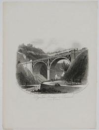
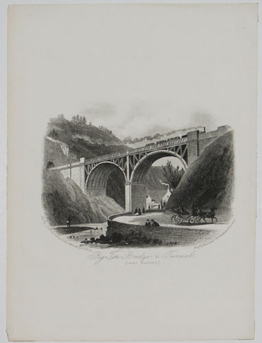
Pig Tor Bridge & Tunnel (near Buxton).
Eng.d by Newman & Co. 48 Watling St. London.
Pub.d by John Cumming Bates, Advertiser Office.
Engraving. 178 x 132mm (7 x 5¼"). Rare.
A train crossing the bridge at Pig Tor, Derbyshire, over the River Derwent in the Peak District.
[Ref: 30987] £55.00
(£66.00 incl.VAT)
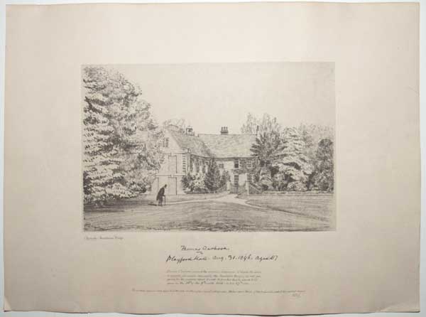
Thomas Clarkson. Playford Hall. Aug. 31. 1846, aged 87. Thomas Clarkson penned the original Autograph, (of which the above is a perfect facsimile, obtained by the Anastatic Press) in ink pre-pared for the purpose; about 4 weeks before his death, which took place on the 26th of the 9th month, 1846, in his 87th year. The windows immediately opposite the gate are these of his usual sitting room, the two above them of that where he ended his mortal career. WDS.
W.m Dillwyn Sims [facsilimile within plate].
Ipswich Anastatic Press. [n.d., c.1846.]
Lithograph. Sheet size: 275 x 385mm (10¾ x 15¼"), with very large margins.
A view of Playford Hall, Suffolk, with abolitionist Thomas Clarkson (1760 - 1846), walking towards the gates. Clarkson was founding member of The Society for Effecting the Abolition of the Slave Trade (also known as the Society for the Abolition of the Slave Trade) and helped achieve passage of the Slave Trade Act of 1807, which ended British trade in slaves. Clarkson rented Playford Hall in around 1813 and lived there until his death in 1846.
[Ref: 62208] £110.00
(£132.00 incl.VAT)
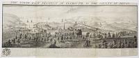
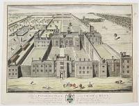
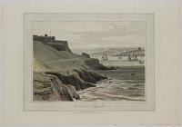
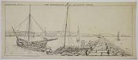
The North-East Prospect of Plymouth, in the County of Devon.
Sam.l and Nath.l Buck delin. et Sculp.t.
according to Act of Parliament 1736.
Engraving. Sheet 310 x 775mm (12¼ x 30½"). Trimmed within plate, three horizontal folds, folded onto album sheet. Staining in sky.
A detailed view of Plymouth, with a descriptive text below and a key to the right, indicating various landmarks and buildings. From the series 'Buck's Perspective Views of Cities and Chief Towns in England and Wales', before the addition of a plate number top right.
[Ref: 42265] £280.00
(£336.00 incl.VAT)
Maison qui serre de magasins, pour la marine du Roy, et une partie de Plimouthe en Angleterre.
[n.d., c.1770.]
Coloured engraving. 260 x 385mm, 10½ x 15¼".
A 'vüe d'optique'of Plymouth, designed to be viewed through an optical viewer called a 'zograscope'. The naive colouring is standard for this genre of prints.
[Ref: 11560] £180.00
(£216.00 incl.VAT)
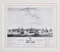
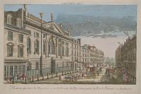
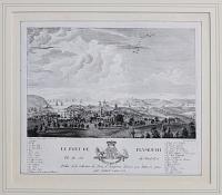
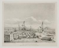
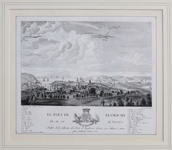
Le Port De Plymouth. Vue du coté de l'Ouest.
Peint par Thom. Milton. Suru et des. Grave par Suntach.
Réduit de la Collection des Prts d'Angleterrede'sines par Milton et graves par Suntach l'anne 1788.
Engraving. Sheet size: 200 x 235mm (8 x 9¼"). Cut inside plate. Glued to backing sheet. A few surface marks.
A view of the port of Plymouth, taken from the west, with numerous sailing vessels in the water, each named in a key below the image, as well as the builidings in the port in the distance. From the collection of prints of English ports, designed by Milton and engraved by Suntach.
[Ref: 38756] £130.00
(£156.00 incl.VAT)
Le Port De Plymouth Vue du coté du Nord-Est.
Peint par Thom. Milton. Suru et des. Grave par Suntach.
Réduit de la Collection des Prts d'Angleterrede'sines par Milton et graves par Suntach l'anne 1788.
Engraving. Sheet size: 200 x 235mm (8 x 9¼"). Cut inside plate. Glued to backing sheet.
A view of the port of Plymouth, taken from the north-east, looking out to sea over the town itself, with numerous buildings including a church in the middle ground, and sailing vessels on the water beyond the port. The points of interest and ships are numbered, with a key below the image. From the collection of prints of English ports, designed by Milton and engraved by Suntach.
[Ref: 38757] £230.00
(£276.00 incl.VAT)
![[Set of six views in Plymouth.]](img-thumbnail/jpegs/38761.jpg)
[Set of six views in Plymouth.] A view of the Lara from Crabtree to the Head of Catwater. [&] A View of the Bloack-House near Dock, with part of the Lines and the Mouth of the Harbour, from Mount Edgcumbe. [&] Mount Wise Fort Plymouth Dock, taken from the Passage Beach. [&] A View of Catwater and part of the Citadel, from the West Hoe. [&] The Entrance to Plymouth Sound and Hamoaze at Low Water, taken from under Mount Wise. [&] A View of St. Nicholas Island and Plymouth Sound, from the Lines at Dock.
Drawn by W. Hay. Eng.d by B.T. Pouncey. [&] J. Pye.
Published by W, Hay 1781 - 1782.
A set of six hand coloured engravings. Very fine. Platemark: 235 x 280mm (9¼ x 11") each. Large margins. Very scarce complete.
A complete set of set of 'Six Views of Plymouth Waterfront', by William Hay. Within ovals, each with a unique dedication and coat of arms below the image. See Ref: 38759 for an uncoloured set.
[Ref: 38761] £950.00
view all images for this item
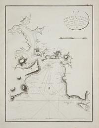
A New & Correct Large Draught of Plymouth South Catt=Water and Ham=ouse.
[by Samuel Thornton.]
[London, 1714-.]
Engraved chart with hand colour. 450 x 560mm (17¾ x 22"). Small margins. Laid on card. Slight central crease as normal.
A chart of Plymouth Sound, originally published in 1714 in Samuel Thornton's 'English Pilot', but here probably published by Mount & Page in one of their reissues of Captain Greenvile Collins' sea atlas, 'Great Britain's Coasting Pilot'.
[Ref: 38774] £360.00
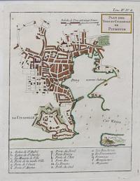
Plan des Ville et Citadelle de Plymouth.
[by Jacques Nicolas Bellin.]
[Paris, 1764.]
Engraved map with hand colour. 235 x 185mm (9¼ x 7¼"). Very large margins.
A plan of Plymouth, showing the bastions of the Citadel, published in the 'Petit Atlas Maritime'.
[Ref: 38777] £130.00
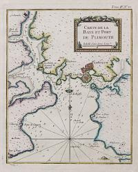
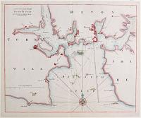
Carte de la Baye et Port de Plimouth.
[by Jacques Nicolas Bellin.]
[Paris, 1764.]
Engraved chart with hand colour. 230 x 185mm (9 x 7¼"). Very large margins.
A chart of Plymouth Sound, marking 'Plimouth' and Saltash, published in the 'Petit Atlas Maritime'.
[Ref: 38779] £130.00
![[Drake's Island, Plymouth]](img-thumbnail/jpegs/53120.jpg)
[Drake's Island, Plymouth]
[n.d. c.1840.]
Lithograph. Sheet 158 x 209mm (6¼ x 8¼"). Trimmed and laid on album sheet, with old ink mss. title.
Drake's Island in Plymouth Harbour, once named for St Nicholas's Chapel. In 1583 Francis Drake was made governor of the island and it began to be fortified, with barracks for 300 men built.
[Ref: 53120] £60.00
(£72.00 incl.VAT)
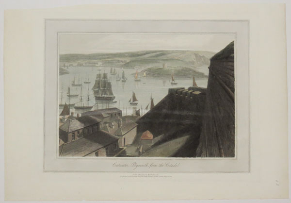
The Citadel, Plymouth.
Drawn & Engraved by Will.m. Daniell.
Published by W. Daniell, Russell lpace, Fitzroy Square, London, May 20, 1825.
Coloured aquatint. Plate: 300 x 230mm (12 x 9"); very large margins.
A view across Plymouth Sound with the Royal Citadel on the left. The citadel was built in 1660 and was built on the site of an earlier fortress designed by Sir Francis Drake. From William Daniell's 'A Voyage Round Great Britain', a series of 308 aquatints published in eight volumes between 1814-1825, described by R.V. Tooley as 'the most important colour plate book on British Topography'.
[Ref: 39512] £240.00
(£288.00 incl.VAT)
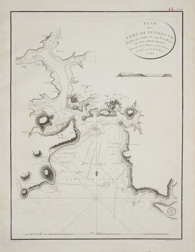
Plan du Port de Plymouth publié par ordre de son Excellence le Vice-Amiral Decrès Ministre de la Marine et des Colonies Au Dépôt de la Marine, en 1803.
Gravé par E. Collin.
[1804.]
Engraved sea chart. 630 x 485mm (24¾ x 19"). Red pagination ink stamp, very large margins. Top right corner of margin torn.
A French sea chart of Plymouth Harbour, published soon after hostilities with Revolutionary France began again after the short 'Peace of Amiens' (1802-3). It shows upstream to Saltash.
[Ref: 43860] £360.00
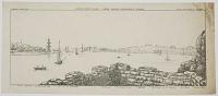
![The North-East Prospect of Plymouth, in the County of Devon. [&] The West Prospect of His Majesties Dock-Yard, Near Plymouth.](img-thumbnail/jpegs/43058.jpg)
The North-East Prospect of Plymouth, in the County of Devon. [&] The West Prospect of His Majesties Dock-Yard, Near Plymouth.
Sam.l and Nath.l Buck delin. et Sculp.t.
according to Act of Parliament 1736.
A pair of engravings. Plates: 310 x 790mm (12¼ x 31"). Central folds as normal.
A pair of detailed views of Plymouth, with a descriptive text below and a key to the right, indicating various landmarks and buildings. From the series 'Buck's Perspective Views of Cities and Chief Towns in England and Wales', before the addition of a plate number top right.
[Ref: 43058] £700.00

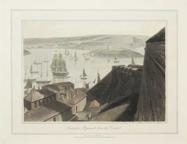
Catwater, Plymouth, from the Citadel.
Drawn & Engraved by Will.m Daniell.
Published by W. Daniell, Russell Place, Fitzroy Square, London May 20. 1825.
Aquatint with hand colour. Plate: 230 x 300mm (9 x 12"), with large margins. On card as usual.
A view of the stretch of water called the Cattewater near Plymouth. From William Daniell's 'A Voyage Round Great Britain', a series of 308 aquatints published in eight volumes between 1814-1825, described by R.V. Tooley as 'the most important colour plate book on British Topography'. Abbey: Scenery, 16; Tooley: Books with Coloured Plates 177.
[Ref: 47280] £220.00
(£264.00 incl.VAT)
A View of the Block-House near Dock, with part of the Lines and the Mouth of the Harbour, from Mount Edgcumbe, Most respectfully Inscribed to Major Gen.l Charles Grey, Col.l of the 28th. Reg.t of Foot, by his most obliged Humble Serv.t W. Hay.
Drawn by W. Hay. Emgraved by B.T. Pouncy.
Published by W. Hay May 1, 1782.
Etching. Plate 242 x 285mm. 9½ x 11¼". Creasing and tear to right-hand edge, large margins.
A coastal view with boats in the harbour mouth; a military post with a flag to the left, buildings on the cliffs beyond. General Charles, 1st Earl Grey (1729-1807). In the BM.
[Ref: 20354] £170.00
(£204.00 incl.VAT)

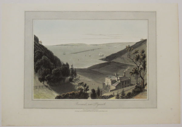
Bovisand, near Plymouth.
Drawn & Engraved by Will.m. Daniell.
Published by W. Daniell, Russell Place, Fitzroy Square, London, May 20, 1825.
Coloured aquatint. Plate: 300 x 230mm (12 x 9"); very large margins.
A view across the Plymouth Sound to the Plymouth Breakwater from Bovisand east of England. From William Daniell's 'A Voyage Round Great Britain', a series of 308 aquatints published in eight volumes between 1814-1825, described by R.V. Tooley as 'the most important colour plate book on British Topography'.
[Ref: 39513] £240.00
(£288.00 incl.VAT)
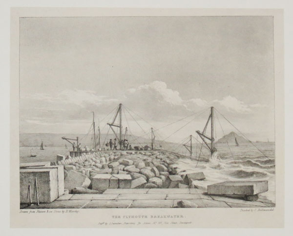
The Plymouth Breakwater.
Drawn from Nature and on Stone by H. Worsley. Printed by C. Hullmandel.
Pub.d by S. Saunders, Repository for Artists, No. 101, Fore Street, Devonport. [n.d., c.1830.]
Lithograph on india. Sheet 190 x 235mm (7½ x 9¼"). Laid on new card.
In 1806 John Rennie and Joseph Whidbey were commissioned to make Plymouth a safe haven for the Channel Fleet during the Napoleonic Wars. Work started in 1812 and four million tons of rock were used, at a cost of £1.5 million, equivalent to £90 million today.
[Ref: 41452] £120.00
(£144.00 incl.VAT)
The Breakwater, in Plymouth Sound.
W Hawkes Smith del. & fec. Printed from Stone, by W.H. Smith.
[n.d., c.1820]
Original pen and ink drawing, drawn area 185 x 420mm (7¼ x 16½"). Unique.
View of Plymouth Sound with key identifying 'one of the carrying Vessels' on the left, and the mewstone on the right. By the little-known Birmingham printmaker William Hawkes Smith (1818-1821, fl.). Ex Collection: The Late Honourable Christopher Lennox-Boyd.
[Ref: 32243] £420.00

Catwater, Plymouth, from the Citadel.
Drawn & Etched by Will.m. Daniell.
Published by W.Daniell, Russel Place, Fitzroy Square, London, May 20, 1825.
Coloured aquatint. Plate: 300 x 230mm (12 x 9"); very large margins.
A view across Cattewater from the Royal Citadel. Cattewater is the pool where the mouth of the River Plym meets Plymouth Sound. Mount Batten and Mout Batten tower can be seen across the water. From William Daniell's 'A Voyage Round Great Britain', a series of 308 aquatints published in eight volumes between 1814-1825, described by R.V. Tooley as 'the most important colour plate book on British Topography'.
[Ref: 39515] £240.00
(£288.00 incl.VAT)
A View of Catwater and part of the Citadel, from the West Hoe, Most respectfully Inscribed to Edward Archer Esq.r and the Gentlemen of the Plymouth Independent Company of Volunteers, by their most Obliged Humble Serv.t W. Hay.
Drawn by W. Hay. Engrav'd by B.T. Pouncy.
Published by W. Hay, May 1, 1782.
Etching. Plate 242 x 286mm. 9½ x 11¼". Large margins.
A river view with ships and fortress with flags to the left. A round castellated tower to the right. In the BM.
[Ref: 20359] £160.00
(£192.00 incl.VAT)
![[Plymouth coastal profiles.]](img-thumbnail/jpegs/13484.jpg)
[Plymouth coastal profiles.]
[Engraved by J.C. Stadler after John Thomas Serres.]
Engrav'd for I.T. Serres's Little Sea Torch, & Publish'd by him, London, 1801.
Aquatint, printed in blue and hand finished. 240 x 390mm, 9½ x 15¼". Occasional spots.
13 finely-coloured coastal profiles of the environs of Plymouth, including the Mew Stone, Ram Head and Stoke Point. Published in Serres's scarce marine pilot, 'The Little Sea Torch', an acknowledged English edition of Bougard's 'Le Petit Flambeau de la Mer', although extensively revised by Serres. Abbey Life: 344.
[Ref: 13484] £180.00
(£216.00 incl.VAT)
Plymouth-Dock, from Oliver Cromwell's Tower.
W. Hawkes Smith, del. Printed from Stone, by W.H. Smith.
[n.d., c.1820]
Lithograph, printed area 180 x 435mm (7¼ x 17"). Messy & crease top right; very rare.
View from Plymouth Dock with key indicating (l-r) 'Mount Edgcombe / Admiral's Ship / Hamoaze / Dock-yard / Dock-yard Chapel / Telegraph / Dock Church / Adm.l's Landing / Adm.l's House / Governm.t House'. By the little-known Birmingham printmaker William Hawkes Smith (1818-1821, fl.). Ex Collection: The Late Honourable Christopher Lennox-Boyd.
[Ref: 32246] £260.00
(£312.00 incl.VAT)
![[Plymouth] To the Subscribers at Lloyds,](img-thumbnail/jpegs/51403.jpg)
[Plymouth] To the Subscribers at Lloyds, This Plate, from an original Painting by W.J. Huggins, representing the disasterous situation of 23 sail of Merchantmen, in Deadman's Bay, and Carwater, Plymouth, as they actually appeared on the third day after the tremendous Gale of the 23rd Nov.r 1824, Is most respectfully dedicated, by their most Obedient Servent, Capt.n James Shepherd.
Painted by W.J. Huggins. Engraved by J. Bluck.
Published Nov.r 1825, by W.J. Huggins, Marine Painter, Printseller & Publisher, 105, Leadenhall Street.
Aquatint, printed in colours and hand-finished. 465 x 810mm (18¼ x 32"). Trimmed to the plate at the sides and the left hand side has two repaired tears including a small amount of loss, some toning of the paper.
Extremely rare and very large aquatint of the aftermath of the Great Storm of 1824, when hurricane force winds struck the south west coast of England. Besides wrecking the ships seen here, it also smashed the Plymouth breakwater, removing 200,000 tons of stone.
[Ref: 51403] £950.00
![[View of the Marine Barracks at Stonehouse, near Plymouth-Dock.]](img-thumbnail/jpegs/38755.jpg)
[View of the Marine Barracks at Stonehouse, near Plymouth-Dock.] To the Right Hon.ble the Lords Commissioners for executing the Office of Lord High Admiral of Great Britain &C. This View of the Marine Barracks at Stonehouse, near Plymouth-Dock - Is humbly Inscribed by their Lordships, most obedient Servant W.m Hay.
Painted by W. Hay. Engraved by B.T. Pouncey.
Published as the Act directs, March 16. 1786 by William Hay, Plymouth.
Hand coloured engraving. Platemark: 360 x 475mm (14¼ x 18¾").
A view across the water of the marine barracks in the background, as viewed from the entrance to Stonehouse Creek. The rocky outcrop on the right is Devil's Point and would later be developed to become the Royal William Yard.
[Ref: 38755] £450.00
Mount Wise Fort Plymouth Dock, taken from the Passage Beach. Most Humbly Inscribed to Lieut.t Gen.l Haviland, Commander in Chief of His Majesty's Forces in the Western District and Col: of the 45th Reg.t by his most obliged humble Serv.t W: Hay.
Drawn by W. Hay. Engraved by B.T. Pouncy.
Published 1.st June 1780.
Etching. Plate 248 x 292mm. 9¾ x 11½".
A coastal view of Plymouth with two boats on the water and soldiers and cargo in the foreground. A fort with flag on the cliffs in the background and a military camp to the right; spire of a church seen behind the hill to the left. In the BM.
[Ref: 20357] £150.00
(£180.00 incl.VAT)


![[St Giles, Oxford] Hanc Ecclesiæ D. Aegidii in Suburbiis Civ. Oxon.](jpegs/42013.jpg)
![[St Mary the Virgin, Oxford.] [No.52]](jpegs/27690.jpg)

![[An Oxfordshire Lane.]](jpegs/61183.jpg)


![[Pembroke Gardens] An Exact Survey of the Beautiful & Magnificent](jpegs/61711.jpg)
![[Pendley Manor] To the Honourable S.r Richard Anderson Bar:t this Plate of the Mannor House of Penley is Humbly Dedicated by John Oliver.](jpegs/62543.jpg)

![[Penshurst.]](jpegs/18622.jpg)


![[Original sketch for Dugdales' England & Wales.] Petworth House, Sussex. Seat of the Earl of Egremont.](jpegs/60265.jpg)


![[Piel Castle] Peel Castle, Lancashire.](jpegs/33896.jpg)
![[Piel Castle] Peel Castle, Lancashire.](jpegs/47282.jpg)


![[Set of six views in Plymouth.]](jpegs/38761.jpg)


![[Drake's Island, Plymouth]](jpegs/53120.jpg)

![The North-East Prospect of Plymouth, in the County of Devon. [&] The West Prospect of His Majesties Dock-Yard, Near Plymouth.](jpegs/43058.jpg)


![[Plymouth coastal profiles.]](jpegs/13484.jpg)

![[Plymouth] To the Subscribers at Lloyds,](jpegs/51403.jpg)
![[View of the Marine Barracks at Stonehouse, near Plymouth-Dock.]](jpegs/38755.jpg)
