![[Johann Andreas Pfeffel.]](img-thumbnail/jpegs/29773.jpg)
[Johann Andreas Pfeffel.]
Georg. de Marees pinxit. Joan. Georg. Pintz sculp.
[Ulm: C.U. Wagner, 1734-35.]
Rare engraving with large margins. 320 x 210mm (12½ x 8¼"). Printer's creases on left.
Johann Andreas Pfeffel (1674-1750), engraver and publisher who issued a map of Hungary in 1709. He published an edition of Scheuchzer's 'Physica Sacra', in which this portrait was published as a frontispiece, with Pfeffel holding the titlepage to the work.
[Ref: 29773] £220.00
(£264.00 incl.VAT)
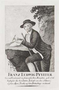
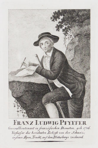
Franz Ludwig Pfyffer. Generallieutenant in französischen Diensten. geb. 1716 Verfaser des berühmten Reliefs von der Schweiz; in seiner Alpen Tracht, auf dem Pilatus berge zeichnend.
C. Westermayr f. [after Joseph Reinhard]
[Weimar: n.d., c.1808.]
Stipple with large margins. Plate 140 x 90mm (5½ x 3½").
Franz Ludwig Pfyffer von Wyher, an officer in the French king's Swiss Guard who made a three-dimensional map of the area around Lake Lucerne, completed in 1786 and now the oldest relief map in existence. He took 24 years to construct it, using available materials including plaster, charcoal, sand, beeswax, brick & pottery, in 136 separate sections for easy transportation. It has been on display in the Glacier Garden in Lucerne for over a century. His military career was also successful: he retired with the rank of lieutenant general in 1768. The portrait was published in 'Allgemeine Geographische Ephemeriden' (Universal Geographical Ephemerides (i.e. encyclopedia)) by Friedrich Bertuch et al. For a larger version of this image see ref. 12163
[Ref: 29605] £130.00
(£156.00 incl.VAT)
![[Franz Ludwig Pfyffer von Wyher] Louis Pfyffer Seigneur de Wyher Lieutenant-General des Armées du Roi de sa Majesté Très-Chret.ne,](img-thumbnail/jpegs/57010.jpg)
[Franz Ludwig Pfyffer von Wyher] Louis Pfyffer Seigneur de Wyher Lieutenant-General des Armées du Roi de sa Majesté Très-Chret.ne, Commandeur de l'Ordre Royal et Militaire de St Louis &c. Né à Lucerne en 1716.
Gravé en 1786.
A Basle chez Chrétien de Mechel Graveur.
Aquatint. Sheet 245 x 175mm (9¾ x 7"). Trimmed within plate, a little soiling.
Franz Ludwig Pfyffer von Wyher, an officer in the French king's Swiss Guard who made a three-dimensional map of the area around Lake Lucerne, completed in 1786 and now the oldest relief map in existance. He took 24 years to construct it, using available materials including plaster, charcoal, sand, beeswax, brick & pottery, in 136 separate sections for easy transportation. It has been on display in the Glacier Garden in Lucerne for over a century. His military career was also successful: he retired with the rank of lieutenant general in 1768.
[Ref: 57010] £140.00
(£168.00 incl.VAT)
![[Franz Ludwig Pfyffer von Wyher] Louis Pfyffer von Wyher Lieutenant General des Armees du Roi de France, qui fet le premier Bas-relief d'une partie de la Suisse; mort a Lucerne on 1802 a l'age de 87 ans.](img-thumbnail/jpegs/12163.jpg)
[Franz Ludwig Pfyffer von Wyher] Louis Pfyffer von Wyher Lieutenant General des Armees du Roi de France, qui fet le premier Bas-relief d'une partie de la Suisse; mort a Lucerne on 1802 a l'age de 87 ans.
J. Schwegler del. [after a painting by Joseph Reinhard] Lith de B Egli a Lucerne.
[n.d. 1815.]
Lithograph. Sheet 230 x 335mm 9 x 13". Minor creases visible.
Franz Ludwig Pfyffer von Wyher, an officer in the French king's Swiss Guard who made a three-dimensional map of the area around Lake Lucerne, completed in 1786 and now the oldest relief map in existance. He took 24 years to construct it, using available materials including plaster, charcoal, sand, beeswax, brick & pottery, in 136 separate sections for easy transportation. It has been on display in the Glacier Garden in Lucerne for over a century. His military career was also successful: he retired with the rank of lieutenant general in 1768.
[Ref: 12163] £140.00
(£168.00 incl.VAT)
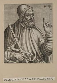
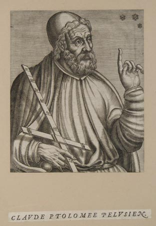
Claude Ptolomee Pelusien.
[n.d., c.1584.]
Engraving, trimmed to image and glued to album page with excised title below, image 170 x 142mm.
Claudius Ptolemaeus (83 161 AD), known in English as Ptolemy, was an ancient mathematician, geographer, astronomer, and astrologer. He lived in Roman Egypt, and was probably born there in a town in the Thebaid called Ptolemais Hermiou; he died in Alexandria in 161 AD. From André Thevet's 'Portraits et vies des hommes illustres', Paris, 1584. Not in Wellcome.
[Ref: 7768] £95.00
(£114.00 incl.VAT)
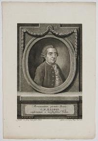
Monumentum pietatis Beato G.N. Raspio consecratum a moestissima Vidua.
Gemahl: von George Christ: Gottl: v. Bemel. Gestochen von Joh: Georg Klinger Nurnb: 1787.
Stipple, rare with large margins. Plate 210 x 159mm (8¼ x 6¼").
Gabriel Nikolaus Raspe (1769-1829), cartographer and publisher. Among his publications was 'Schau Platz des gegenwaertigen Kriegs' (Plates illustrating the Current Wars), with maps illustratrating the events of the Seven Year's War (1756-63).
[Ref: 29907] £160.00
(£192.00 incl.VAT)
![[Major James Rennell F.R.S.]](img-thumbnail/jpegs/57014.jpg)
[Major James Rennell F.R.S.]
Drawn by Scott. Engraved by A. Cardon.
London. Published as the Act directs, February 1799.
Fine stipple, proof before title. 205 x 115mm (8 x 6¼"), with large margins.
Major James Rennell (1742-1830), regarded as the Father of both Indian Cartography (for his survey of Bengal for the East India Company) and Oceanography (for his study of ocean currents). He compiled a map for the account of Mungo Park's first expedition to the Niger River that started the myth of the 'Mountains of Kong'.
[Ref: 57014] £180.00
(£216.00 incl.VAT)
![[Major James Rennell F.R.S.]](img-thumbnail/jpegs/57015.jpg)
[Major James Rennell F.R.S.]
[Drawn by Scott. Engraved by A. Cardon.]
[London. Published as the Act directs, February 1799.]
Stipple, proof before letters. Sheet 205 x 115mm (8 x 6¼"). Trimmed to plate.
Major James Rennell (1742-1830), regarded as the Father of both Indian Cartography (for his survey of Bengal for the East India Company) and Oceanography (for his study of ocean currents). He compiled a map for the account of Mungo Park's first expedition to the Niger River that started the myth of the 'Mountains of Kong'.
[Ref: 57015] £160.00
(£192.00 incl.VAT)
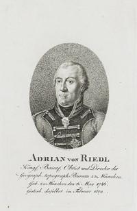
Adrian von Riedl. Köngl. Bairl. Obrist und Director des Geograph. topograph. Bureau zu München. Geb. zu München den g: May 1746. Gestorb. daselbst im Februar 1809.
C.A. Schwerdgeburth sc.
[Weimar: n.d., c.1810.]
Stipple with large margins. Plate 140 x 90mm (5½ x 3½").
Adrian von Riedl (1746-1809), a German military surveyor, best known for his 'Reise-Atlas von Baiern' (Road Atlas of Bavaria) , Munich 1796-1805. The portrait was published in 'Allgemeine Geographische Ephemeriden' (Universal Geographical Ephemerides (i.e. encyclopedia)) by Friedrich Bertuch et al.
[Ref: 29611] £80.00
(£96.00 incl.VAT)
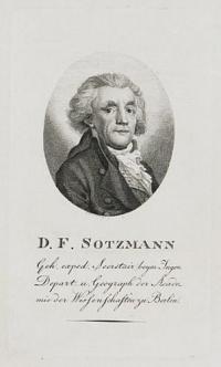
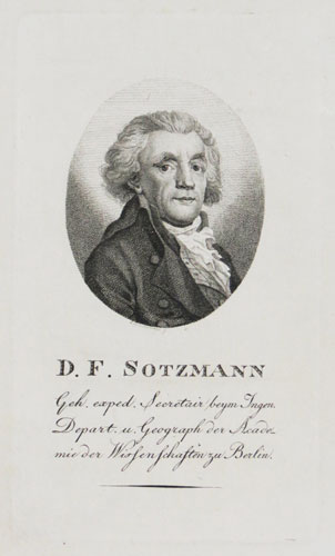
D.F. Sotzmann. Geh. exped. Secretair beym Ingen. Depart. u Geograph der Academie der Wissenschaften zu Berlin.
C. Westermayr f.
[Weimar: n.d., c.1808.]
Stipple with large margins. Plate 140 x 90mm (5½ x 3½").
Daniel Friedrich Sotzmann, a geographer who compiled the maps for the 'Atlas Von Nordamerika', part of Ebeling's seven volume 'Erdbeschreibung und Geschichte von Amerika'. Sotzmann only completed ten of the intended 18 maps, based on contemprary American maps including Carey, all highly-detailed with symbols for churches, roads, court houses, distilleries, iron works, mills, academies, etc. Complete sets of ten are rare. The portrait was published in 'Allgemeine Geographische Ephemeriden' (Universal Geographical Ephemerides (i.e. encyclopedia)) by Friedrich Bertuch et al.
[Ref: 29609] £130.00
(£156.00 incl.VAT)
John Speed.
Pub.d 1816, by T. Rodd, 2.G.t Newport St. Long Acre.
Engraving. Watermarked: J. Whatman. Plate 165 x 120mm. 6½ x 4¾". Large paper copy, mint.
John Speed (1552?-1629), historian, cartographer and antiquary. He produced the first World Atlas by an Englishman, entitled 'A Prospect of the Most Famous Parts of the World', which first appeared in London in 1627.
[Ref: 19064] £250.00
(£300.00 incl.VAT)
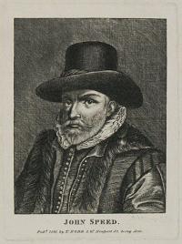
![[John Speed.]](img-thumbnail/jpegs/14952.jpg)
[John Speed.]
W: S. Carey, Sct.
[n.d., c.1820.]
Engraving, sheet 165 x 125mm, 6½ x 5".
John Speed (1552? - 1629), historian, cartographer and antiquary. He produced the first World Atlas by an Englishman, entitled 'A Prospect of the Most Famous Parts of the World', which first appeared in London in 1627. A 19th century copy of a 17th century engraving.
[Ref: 14952] £160.00
(£192.00 incl.VAT)
![[John Speed.]](img-thumbnail/jpegs/57475.jpg)
[John Speed.]
[after Solomon Savery.]
[n.d., c.1840.]
Engraving. 180 x 135mm (7 x 5¼"), on wove paper with large margins.
John Speed (1552? - 1629), historian and antiquary famous for his county atlas, the 'Theatre of the Empire of Great Britaine' (1611-1612) and England's first world atlas, 'A Prospect of the Most Famous Parts of the World' (1627). This is a 19th century copy of the frontispiece portrait from the combined edition of Speed's two atlases (1632), engraved by Salomon Savery. NPG D42573.
[Ref: 57475] £160.00
(£192.00 incl.VAT)
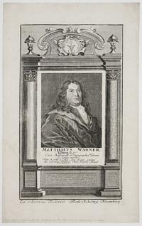
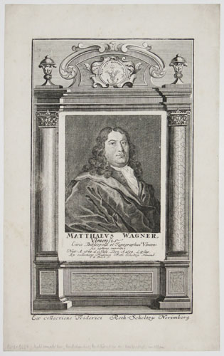
Matthaeus Wagner, Ulmensis Civis Bibliopola et Typographus Ulmensis optime meritus.
T.G. Beck sc.
Ex collectione Friderici Roth-Scholtzü Norimberg. [Nuremberg, n.d., c.1729.]
Engraving with architectural surround printed from separate plate; very large margins. 290 x 170mm (11½ x 6¾"). Laid on album paper.
Portrait of Matthaüs Wagner (1648-94), publisher in Ulm who issued Everhard Werner Happel's ' Historia Moderna Europae' posthumously in 1692, containing many maps and engravings of events.
[Ref: 29772] £240.00
(£288.00 incl.VAT)
![[Johann Andreas Pfeffel.]](jpegs/29773.jpg)
![[Franz Ludwig Pfyffer von Wyher] Louis Pfyffer Seigneur de Wyher Lieutenant-General des Armées du Roi de sa Majesté Très-Chret.ne,](jpegs/57010.jpg)
![[Franz Ludwig Pfyffer von Wyher] Louis Pfyffer von Wyher Lieutenant General des Armees du Roi de France, qui fet le premier Bas-relief d'une partie de la Suisse; mort a Lucerne on 1802 a l'age de 87 ans.](jpegs/12163.jpg)

![[Major James Rennell F.R.S.]](jpegs/57014.jpg)
![[Major James Rennell F.R.S.]](jpegs/57015.jpg)


![[John Speed.]](jpegs/14952.jpg)
![[John Speed.]](jpegs/57475.jpg)