Catalogue: England
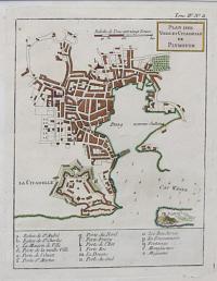
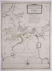
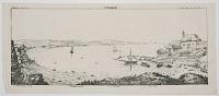
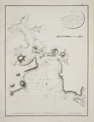
Plan des Ville et Citadelle de Plymouth.
[by Jacques Nicolas Bellin.]
[Paris, 1764.]
Engraved map with hand colour. 235 x 185mm (9¼ x 7¼"). Very large margins.
A plan of Plymouth, showing the bastions of the Citadel, published in the 'Petit Atlas Maritime'.
[Ref: 38777] £130.00
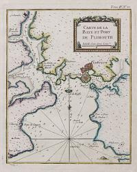
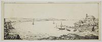
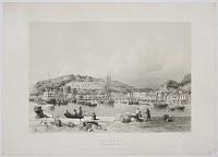
Carte de la Baye et Port de Plimouth.
[by Jacques Nicolas Bellin.]
[Paris, 1764.]
Engraved chart with hand colour. 230 x 185mm (9 x 7¼"). Very large margins.
A chart of Plymouth Sound, marking 'Plimouth' and Saltash, published in the 'Petit Atlas Maritime'.
[Ref: 38779] £130.00
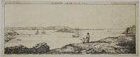
![[Drake's Island, Plymouth]](img-thumbnail/jpegs/53120.jpg)
[Drake's Island, Plymouth]
[n.d. c.1840.]
Lithograph. Sheet 158 x 209mm (6¼ x 8¼"). Trimmed and laid on album sheet, with old ink mss. title.
Drake's Island in Plymouth Harbour, once named for St Nicholas's Chapel. In 1583 Francis Drake was made governor of the island and it began to be fortified, with barracks for 300 men built.
[Ref: 53120] £60.00
(£72.00 incl.VAT)
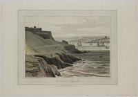
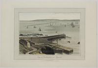
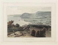
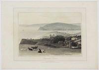
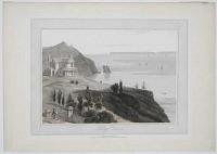
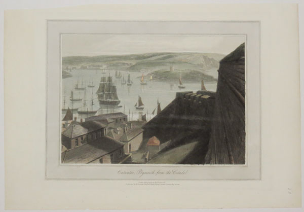
The Citadel, Plymouth.
Drawn & Engraved by Will.m. Daniell.
Published by W. Daniell, Russell lpace, Fitzroy Square, London, May 20, 1825.
Coloured aquatint. Plate: 300 x 230mm (12 x 9"); very large margins.
A view across Plymouth Sound with the Royal Citadel on the left. The citadel was built in 1660 and was built on the site of an earlier fortress designed by Sir Francis Drake. From William Daniell's 'A Voyage Round Great Britain', a series of 308 aquatints published in eight volumes between 1814-1825, described by R.V. Tooley as 'the most important colour plate book on British Topography'.
[Ref: 39512] £240.00
(£288.00 incl.VAT)
Plan du Port de Plymouth publié par ordre de son Excellence le Vice-Amiral Decrès Ministre de la Marine et des Colonies Au Dépôt de la Marine, en 1803.
Gravé par E. Collin.
[1804.]
Engraved sea chart. 630 x 485mm (24¾ x 19"). Red pagination ink stamp, very large margins. Top right corner of margin torn.
A French sea chart of Plymouth Harbour, published soon after hostilities with Revolutionary France began again after the short 'Peace of Amiens' (1802-3). It shows upstream to Saltash.
[Ref: 43860] £360.00
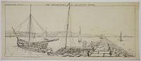
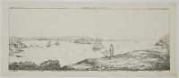
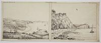
![The North-East Prospect of Plymouth, in the County of Devon. [&] The West Prospect of His Majesties Dock-Yard, Near Plymouth.](img-thumbnail/jpegs/43058.jpg)
The North-East Prospect of Plymouth, in the County of Devon. [&] The West Prospect of His Majesties Dock-Yard, Near Plymouth.
Sam.l and Nath.l Buck delin. et Sculp.t.
according to Act of Parliament 1736.
A pair of engravings. Plates: 310 x 790mm (12¼ x 31"). Central folds as normal.
A pair of detailed views of Plymouth, with a descriptive text below and a key to the right, indicating various landmarks and buildings. From the series 'Buck's Perspective Views of Cities and Chief Towns in England and Wales', before the addition of a plate number top right.
[Ref: 43058] £700.00

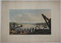
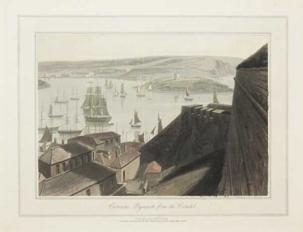
Catwater, Plymouth, from the Citadel.
Drawn & Engraved by Will.m Daniell.
Published by W. Daniell, Russell Place, Fitzroy Square, London May 20. 1825.
Aquatint with hand colour. Plate: 230 x 300mm (9 x 12"), with large margins. On card as usual.
A view of the stretch of water called the Cattewater near Plymouth. From William Daniell's 'A Voyage Round Great Britain', a series of 308 aquatints published in eight volumes between 1814-1825, described by R.V. Tooley as 'the most important colour plate book on British Topography'. Abbey: Scenery, 16; Tooley: Books with Coloured Plates 177.
[Ref: 47280] £220.00
(£264.00 incl.VAT)
A View of the Block-House near Dock, with part of the Lines and the Mouth of the Harbour, from Mount Edgcumbe, Most respectfully Inscribed to Major Gen.l Charles Grey, Col.l of the 28th. Reg.t of Foot, by his most obliged Humble Serv.t W. Hay.
Drawn by W. Hay. Emgraved by B.T. Pouncy.
Published by W. Hay May 1, 1782.
Etching. Plate 242 x 285mm. 9½ x 11¼". Creasing and tear to right-hand edge, large margins.
A coastal view with boats in the harbour mouth; a military post with a flag to the left, buildings on the cliffs beyond. General Charles, 1st Earl Grey (1729-1807). In the BM.
[Ref: 20354] £170.00
(£204.00 incl.VAT)

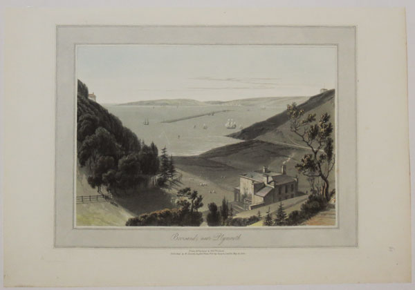
Bovisand, near Plymouth.
Drawn & Engraved by Will.m. Daniell.
Published by W. Daniell, Russell Place, Fitzroy Square, London, May 20, 1825.
Coloured aquatint. Plate: 300 x 230mm (12 x 9"); very large margins.
A view across the Plymouth Sound to the Plymouth Breakwater from Bovisand east of England. From William Daniell's 'A Voyage Round Great Britain', a series of 308 aquatints published in eight volumes between 1814-1825, described by R.V. Tooley as 'the most important colour plate book on British Topography'.
[Ref: 39513] £240.00
(£288.00 incl.VAT)
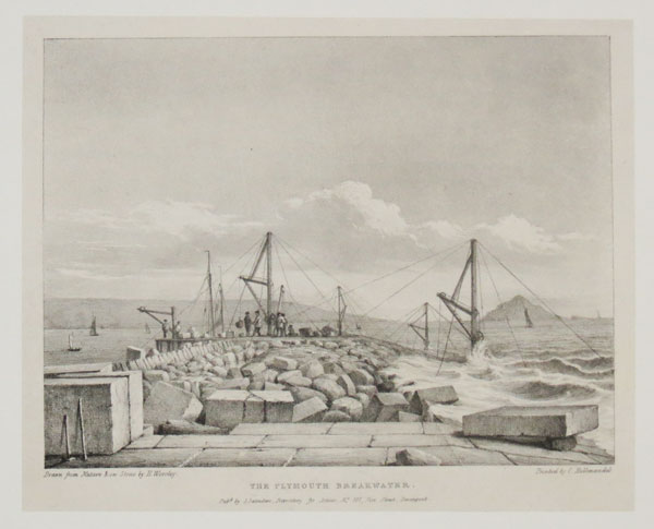
The Plymouth Breakwater.
Drawn from Nature and on Stone by H. Worsley. Printed by C. Hullmandel.
Pub.d by S. Saunders, Repository for Artists, No. 101, Fore Street, Devonport. [n.d., c.1830.]
Lithograph on india. Sheet 190 x 235mm (7½ x 9¼"). Laid on new card.
In 1806 John Rennie and Joseph Whidbey were commissioned to make Plymouth a safe haven for the Channel Fleet during the Napoleonic Wars. Work started in 1812 and four million tons of rock were used, at a cost of £1.5 million, equivalent to £90 million today.
[Ref: 41452] £120.00
(£144.00 incl.VAT)
The Breakwater, in Plymouth Sound.
W Hawkes Smith del. & fec. Printed from Stone, by W.H. Smith.
[n.d., c.1820]
Original pen and ink drawing, drawn area 185 x 420mm (7¼ x 16½"). Unique.
View of Plymouth Sound with key identifying 'one of the carrying Vessels' on the left, and the mewstone on the right. By the little-known Birmingham printmaker William Hawkes Smith (1818-1821, fl.). Ex Collection: The Late Honourable Christopher Lennox-Boyd.
[Ref: 32243] £420.00

Catwater, Plymouth, from the Citadel.
Drawn & Etched by Will.m. Daniell.
Published by W.Daniell, Russel Place, Fitzroy Square, London, May 20, 1825.
Coloured aquatint. Plate: 300 x 230mm (12 x 9"); very large margins.
A view across Cattewater from the Royal Citadel. Cattewater is the pool where the mouth of the River Plym meets Plymouth Sound. Mount Batten and Mout Batten tower can be seen across the water. From William Daniell's 'A Voyage Round Great Britain', a series of 308 aquatints published in eight volumes between 1814-1825, described by R.V. Tooley as 'the most important colour plate book on British Topography'.
[Ref: 39515] £240.00
(£288.00 incl.VAT)
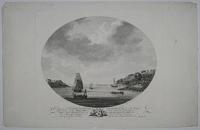
A View of Catwater and part of the Citadel, from the West Hoe, Most respectfully Inscribed to Edward Archer Esq.r and the Gentlemen of the Plymouth Independent Company of Volunteers, by their most Obliged Humble Serv.t W. Hay.
Drawn by W. Hay. Engrav'd by B.T. Pouncy.
Published by W. Hay, May 1, 1782.
Etching. Plate 242 x 286mm. 9½ x 11¼". Large margins.
A river view with ships and fortress with flags to the left. A round castellated tower to the right. In the BM.
[Ref: 20359] £160.00
(£192.00 incl.VAT)
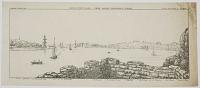
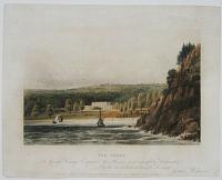
![[Plymouth coastal profiles.]](img-thumbnail/jpegs/13484.jpg)
[Plymouth coastal profiles.]
[Engraved by J.C. Stadler after John Thomas Serres.]
Engrav'd for I.T. Serres's Little Sea Torch, & Publish'd by him, London, 1801.
Aquatint, printed in blue and hand finished. 240 x 390mm, 9½ x 15¼". Occasional spots.
13 finely-coloured coastal profiles of the environs of Plymouth, including the Mew Stone, Ram Head and Stoke Point. Published in Serres's scarce marine pilot, 'The Little Sea Torch', an acknowledged English edition of Bougard's 'Le Petit Flambeau de la Mer', although extensively revised by Serres. Abbey Life: 344.
[Ref: 13484] £180.00
(£216.00 incl.VAT)
Plymouth-Dock, from Oliver Cromwell's Tower.
W. Hawkes Smith, del. Printed from Stone, by W.H. Smith.
[n.d., c.1820]
Lithograph, printed area 180 x 435mm (7¼ x 17"). Messy & crease top right; very rare.
View from Plymouth Dock with key indicating (l-r) 'Mount Edgcombe / Admiral's Ship / Hamoaze / Dock-yard / Dock-yard Chapel / Telegraph / Dock Church / Adm.l's Landing / Adm.l's House / Governm.t House'. By the little-known Birmingham printmaker William Hawkes Smith (1818-1821, fl.). Ex Collection: The Late Honourable Christopher Lennox-Boyd.
[Ref: 32246] £260.00
(£312.00 incl.VAT)
![[Plymouth] To the Subscribers at Lloyds,](img-thumbnail/jpegs/51403.jpg)
[Plymouth] To the Subscribers at Lloyds, This Plate, from an original Painting by W.J. Huggins, representing the disasterous situation of 23 sail of Merchantmen, in Deadman's Bay, and Carwater, Plymouth, as they actually appeared on the third day after the tremendous Gale of the 23rd Nov.r 1824, Is most respectfully dedicated, by their most Obedient Servent, Capt.n James Shepherd.
Painted by W.J. Huggins. Engraved by J. Bluck.
Published Nov.r 1825, by W.J. Huggins, Marine Painter, Printseller & Publisher, 105, Leadenhall Street.
Aquatint, printed in colours and hand-finished. 465 x 810mm (18¼ x 32"). Trimmed to the plate at the sides and the left hand side has two repaired tears including a small amount of loss, some toning of the paper.
Extremely rare and very large aquatint of the aftermath of the Great Storm of 1824, when hurricane force winds struck the south west coast of England. Besides wrecking the ships seen here, it also smashed the Plymouth breakwater, removing 200,000 tons of stone.
[Ref: 51403] £950.00
![[View of the Marine Barracks at Stonehouse, near Plymouth-Dock.]](img-thumbnail/jpegs/38755.jpg)
[View of the Marine Barracks at Stonehouse, near Plymouth-Dock.] To the Right Hon.ble the Lords Commissioners for executing the Office of Lord High Admiral of Great Britain &C. This View of the Marine Barracks at Stonehouse, near Plymouth-Dock - Is humbly Inscribed by their Lordships, most obedient Servant W.m Hay.
Painted by W. Hay. Engraved by B.T. Pouncey.
Published as the Act directs, March 16. 1786 by William Hay, Plymouth.
Hand coloured engraving. Platemark: 360 x 475mm (14¼ x 18¾").
A view across the water of the marine barracks in the background, as viewed from the entrance to Stonehouse Creek. The rocky outcrop on the right is Devil's Point and would later be developed to become the Royal William Yard.
[Ref: 38755] £450.00
Mount Wise Fort Plymouth Dock, taken from the Passage Beach. Most Humbly Inscribed to Lieut.t Gen.l Haviland, Commander in Chief of His Majesty's Forces in the Western District and Col: of the 45th Reg.t by his most obliged humble Serv.t W: Hay.
Drawn by W. Hay. Engraved by B.T. Pouncy.
Published 1.st June 1780.
Etching. Plate 248 x 292mm. 9¾ x 11½".
A coastal view of Plymouth with two boats on the water and soldiers and cargo in the foreground. A fort with flag on the cliffs in the background and a military camp to the right; spire of a church seen behind the hill to the left. In the BM.
[Ref: 20357] £150.00
(£180.00 incl.VAT)
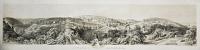
![[Plymouth Panorama.]](img-thumbnail/jpegs/19827.jpg)
[Plymouth Panorama.]
[n.d. c.1825.]
Lithograph. Proof. 172 x 724mm. 6¾ x 28½". Trimmed.
A panorama of Plymouth Sound looking out at Drake's Island, Devon. To the right is Mount Edgcumbe, the estate of the Earls of Mount Edgcumbe. Sailing boats and ships sit in the bay; people in the foreground look out at the view. Not in Abbey.
[Ref: 19827] £290.00
(£348.00 incl.VAT)
![[Set of six views in Plymouth.]](img-thumbnail/jpegs/38759.jpg)
[Set of six views in Plymouth.] A view of the Lara from Crabtree to the Head of Catwater. [&] A View of the Bloack-House near Dock, with part of the Lines and the Mouth of the Harbour, from Mount Edgcumbe. [&] Mount Wise Fort Plymouth Dock, taken from the Passage Beach. [&] A View of Catwater and part of the Citadel, from the West Hoe. [&] The Entrance to Plymouth Sound and Hamoaze at Low Water, taken from under Mount Wise. [&] A View of St. Nicholas Island and Plymouth Sound, from the Lines at Dock.
Drawn by W. Hay. Eng.d by B.T. Pouncey. [&] J. Pye.
Published by W, Hay 1781 - 1782.
A set of six engravings. Very fine. Platemark: 235 x 280mm (9¼ x 11") each. Very scarce complete.
A complete set of set of 'Six Views of Plymouth Waterfront', by William Hay. Within ovals, each with a unique dedication and coat of arms below the image. For a coloured example of this set, see item ref: 38761.
[Ref: 38759] £1,250.00
view all images for this item
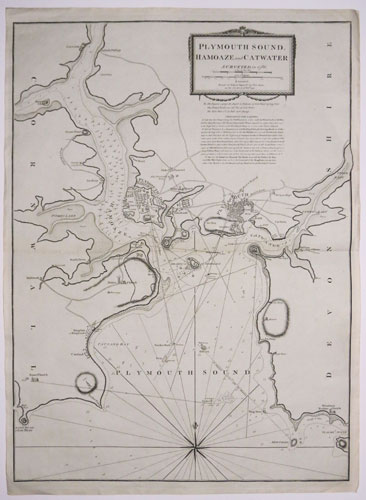
Plymouth Sound. Haoaze and Catwater Surveyed in 1786.
London, Printed for Robert Sayer, No 53, Fleet Street, as the Act directs 10th Feb.ry, 1791.
Engraved map. 710 x 530mm (28 x 21"). Slight loss of paper at centre fold.
A detailed sea chart of the environs of Plymouth, showing the Tamar up to Saltash. with Ram Head lower left and the Great Mew Stone and Wembury lower right.
[Ref: 38815] £295.00
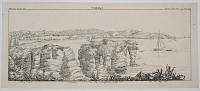
Plymouth Sound, from Devil's Point.
W Hawkes Smith, del. & fec. Printed from Stone, by W.H. Smith, 1820
Original pen and ink drawing, drawn area 185 x 440mm (7¼ x 17½"). Unique.
View of Plymouth Sound with key identifying (l-r) 'Citadel / Opening to Catwater / Mount-Batton, on which is one of O. Cromwell's Towers / St. Nicholas' or Drake's Island / The Breakwater / Mount Edgcombe'. By the little-known Birmingham printmaker William Hawkes Smith (1818-1821, fl.). Ex Collection: The Late Honourable Christopher Lennox-Boyd.
[Ref: 32244] £420.00
Sound; -From Devil's Point
W. Hawkes Smith, del. & fec. Printed from Stone, by W.H. Smith.
[n.d., c.1820]
Lithograph, printed area 180 x 440mm (7¼ x 17"). Crease on right; very rare.
View of Plymouth Sound with key indicating (l-r) 'Citadel / Opening to Catswater / Mount Batton, on which is one of O. Cromwell's Towers / St. Nicholas, or Drake's Island / The Breakwater / Mount Edgcombe'. By the little-known Birmingham printmaker William Hawkes Smith (1818-1821, fl.). Ex Collection: The Late Honourable Christopher Lennox-Boyd.
[Ref: 32247] £260.00
(£312.00 incl.VAT)
![[A view of Plymouth sound, taken from the Rope House, Plymouth Dock]](img-thumbnail/jpegs/27845.jpg)
[A view of Plymouth sound, taken from the Rope House, Plymouth Dock] To the R.t H.ble George Edgcumbe, Earl of Mount of Edgcumbe, Visc.t Valletort. This view of Plymouth Sound, taken from the Rope House Plymouth Dock is dedicated by his Lordship's most obedient humble serv.t Charles Tomkins.
Painted by W. Tomkins. Engraved by C. Tomkins.
Stipple engraving, scarce. Printed area: 350 x 350mm. 13.5" x 13.5".
Plymouth Sound, or known locally as just The Sound, is a bay at Plymouth in England.
[Ref: 27845] £260.00
(£312.00 incl.VAT)
![[A view of Plymouth sound, taken from the Rope House, Plymouth Dock]](img-thumbnail/jpegs/38753.jpg)
[A view of Plymouth sound, taken from the Rope House, Plymouth Dock] To the R.t H.ble George Edgcumbe, Earl of Mount of Edgcumbe, Visc.t Valletort. This view of Plymouth Sound, taken from the Rope House Plymouth Dock is dedicated by his Lordship's most obedient humble serv.t Charles Tomkins.
Painted by W. Tomkins. Engraved by C. Tomkins.
[n.d., c. 1790.]
Hand coloured stipple. Scarce. Sheet size: 410 x 345mm (16 x 13½"). Trimmed to image. Repaired damage along bottom edge.
A view of Plymouth Sound, through a circular trompe l'oel window, with a number of figures, including fishermen, in the foreground and several sailing boats on the water behind.
[Ref: 38753] £450.00
The Entrance of Plymouth Sound and Hamoaze at Low Water taken from under Mount Wise. Most Humbly Inscribed to Lieu.t Gen.l Haviland, Commander in Chief of His Majesty's Forces in the Western District, and Col: of the 45th Reg.t by his most obliged humble Serv.t W. Hay.
Drawn by W. Hay. Engraved by J. Pye.
Publishe 1.st June 1780.
Etching. Plate 253 x 298mm. 10 x 11¾". Large margins.
Plymouth with boats in the estuary at the entrance to Plymouth Sound; a small neoclassical temple to the right, part of Mount Edgecombe. In the BM.
[Ref: 20358] £150.00
(£180.00 incl.VAT)

A View of St Nicholas Island and Plymouth Sound, from the Lines at Dock. Most Respectfully Inscribed to Major Gen.l Charles Grey, Col.l of the 28th Reg.t of Foot by his most obliged Humble Serv.t W. Hay.
Drawn by Wm. Hay. Eng.d by Pouncy.
Published by W. Hay Dec.r 1. 1781.
Etching. Plate 248 x 292mm. 9¾ x 11½". Large margins.
Coastal view of boats in the bay around Drake's Island in the Plymouth Sound; the fortified prison on the island. General Charles, 1st Earl Grey (1729-1807). In the BM.
[Ref: 20355] £150.00
(£180.00 incl.VAT)
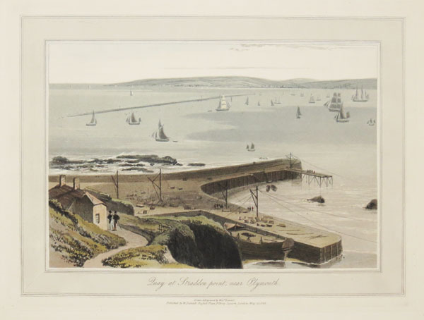
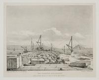
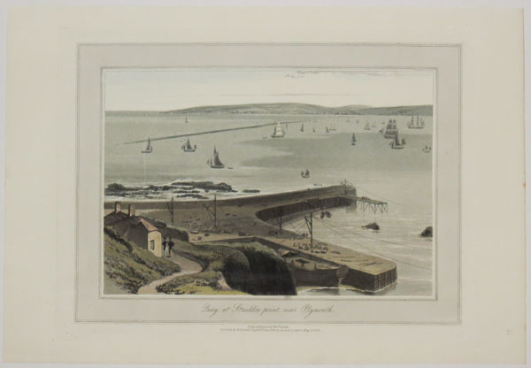
Quay at Straddon point, near Plymouth.
Drawn & Engraved by Will.m. Daniell.
Published by W. Daniell, Russel Place, Fitzroy Square, London, May 20, 1825.
Coloured aquatint. Plate: 300 x 230mm (12 x 9"); very large margins.
A view at Straddon Point showing the harbour and the sandbank. The harbour is full of boats and there are several figures on the jetty. From William Daniell's 'A Voyage Round Great Britain', a series of 308 aquatints published in eight volumes between 1814-1825, described by R.V. Tooley as 'the most important colour plate book on British Topography'.
[Ref: 39511] £240.00
(£288.00 incl.VAT)
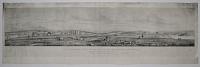
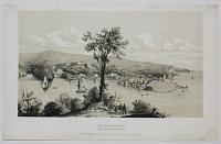
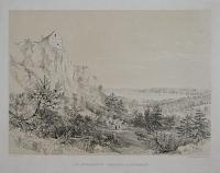
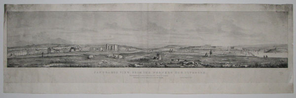
Panoramic View from the Western Hoe Plymouth.
Drawn from Nature & on Stone by H. Worsely, 1826. Printed by C. Hullmandel.
Published by Longman & Co. Paternoster Row, & W. Curtis, Plymouth. Ent.d at Stationers Hall.
Lithograph, rare and laid on sheet. India 202 x 723mm. 8 x 28½". Some soiling and spotting.
A view from Plymouth Hoe, the large south facing space along coastlime. Not in Abbey. In the Library of Devon County Council.
[Ref: 23360] £290.00
(£348.00 incl.VAT)
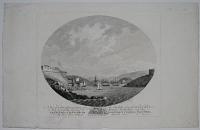
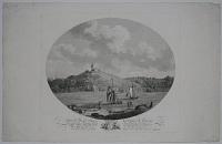
![[Powderham Castle] To S.r William Courtenay Bar.t, Knight of the Shire of Devon](img-thumbnail/jpegs/52626.jpg)
[Powderham Castle] To S.r William Courtenay Bar.t, Knight of the Shire of Devon This South East View of Powderham Castle near Exeter is most humbly Inscrib'd by His very Obedient Serv.ts Sam:l & Nath:l Bucks.
Sam.l & Nath.l Buck delin. et sculp.
Publish'd according to Act of Parliament April 15th 1745. No I Middle Temple London.
Rare engraving. 380 x 590mm (15 x 23¼"). Trimmed within plate left and top left for binding in a scrapbook, folded at centre.
A view of Powderham Castle from the Ex, prior to the alterations by James Wyatt in the 1790s.
[Ref: 52626] £420.00
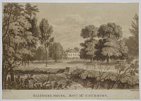
Salcombe House, _Revd. Mr. Cockburn.
H. Haseler del. D. Havell sculp.
[Sidmouth: J. Wallis, 1816-17.]
Sepia aquatint, sheet 140 x 200mm. 5½ x 8". Trimmed to image on three sides; trace of diagonal crease.
A Devon residence in a landscape; two women, one with parasol, walking by a river with a weir in foreground. From H. Haseler's 'Sidmouth Scenery, or views of the principal cottages and residences ... at that ... watering place.' Abbey 307, 20. See BL 10352.d.2.
[Ref: 21979] £65.00
(£78.00 incl.VAT)
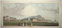
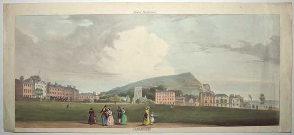
View of the Terrace. Sidmouth.
[n.d., c.1825.]
Coloured lithograph. Sheet 200 x 450mm (8 x 17¾"). Trimmed, losing inscriptions, titles(?) laid on, creasing on right.
A view of Sidmouth looking east to Salcombe Hill.
[Ref: 61367] £180.00
(£216.00 incl.VAT)
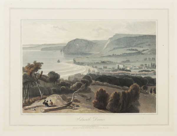
Sidmouth, Devon.
Drawn & Engraved by Will.m Daniell.
Published by W. Daniell, Russell Place, Fitzroy Square, London May 20. 1825.
Aquatint with hand colour. Plate: 230 x 300mm (9 x 12"), with large margins. On card as issued.
A view of Sidmouth in Devon. From William Daniell's 'A Voyage Round Great Britain', a series of 308 aquatints published in eight volumes between 1814-1825, described by R.V. Tooley as 'the most important colour plate book on British Topography'. Abbey: Scenery, 16; Tooley: Books with Coloured Plates 177.
[Ref: 47283] £220.00
(£264.00 incl.VAT)

Quay at Straddon point, near Plymouth.
Drawn & Engraved by Will.m Daniell.
Published by W. Daniell, Russell Place, Fitzroy Square, London May 20. 1825.
Aquatint with fine original hand colour. 230 x 300mm (9 x 12"). Large margins.
A view of Staddon Point on the south Devon coast. From William Daniell's 'A Voyage Round Great Britain', a series of 308 aquatints published in eight volumes between 1814-1825, described by R.V. Tooley as 'the most important colour plate book on British Topography'. Abbey: Scenery, 16; Tooley: Books with Coloured Plates 177.
[Ref: 47139] £240.00
(£288.00 incl.VAT)

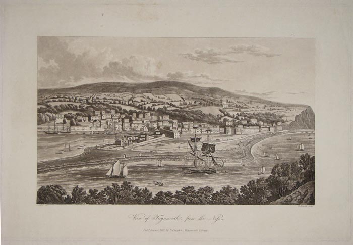
View of Teignmouth, from the Ness.
Noble del.t. D. Havell sculp.t.
Pubd. August, 1817, by E. Croydon, Teignmouth Library.
Aquatint in brown ink, 250 x 375mm (9¾ x 14¾").
Panorama of Teignmouth in Devon, on the north bank of the estuary mouth of the River Teign. Boats on the water in foreground. Plate to W.B. Noble's 'A guide to the watering-places, on the coast, between the Exe and the Dart, including Teignmouth, Dawlish, and Torquay...' See Abbey Scenery: 115.
[Ref: 11536] £140.00
(£168.00 incl.VAT)
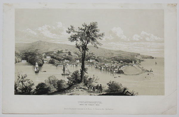
Teignmouth, From the Torquay Road.
Drawn, Printed & Published by G. Rowe: 9, Clarence Str. Cheltenham. [n.d. c.1830].
Sepia-tinted lithograph heightened in white, image 185 x 325mm. 7¼ x 12¾". Very rare.
Panoramic view of Teignmouth in Devon, on the north bank of the estuary mouth of the River Teign. Ships on the water in foreground.
[Ref: 26449] £130.00
(£156.00 incl.VAT)
Teignmouth Bridge, from the Quay. This Bridge was Designed by and Executed under the direction of Roger Hopkins, Civil Engineer, &c.&c.&c.
Strutt Delt. C. Rosenberg Sc.
Published by E. Croydon, June 5th. 1827, Public Library, Teignmouth.
Hand coloured aquatint, 265 x 360mm. 10½ x 14¼". Slightly soiled; stain to sky.
Scarce locally-published print of the first Shaldon Bridge, which crossed the estuary mouth of the River Teign at Teignmouth, Devon. Figures and cargo on quayside in foreground. The original bridge was owned by the Teignmouth and Shaldon Bridge Company and opened on 8 June 1827. It had 34 wooden arches and was 1,671 feet long, which made it the longest wooden bridge in England when built. It had abutment walls of a considerable length at either end, and a swing bridge at the Teignmouth end to allow sailing ships to pass up the estuary. It cost around £19,000 to build, but the overall expenditure was about £26,000 due to the costs of the necessary Act of Parliament and the purchase of the old ferry-rights. Toll houses were built at each end of the bridge, and the one on the Teignmouth side still survives. After only eleven years, on 27 June 1838 the centre arches of the bridge collapsed, the timbers being eaten through by shipworms. It was rebuilt in wood and reopened in 1840, but it partially collapsed again in 1893. The bridge was completely rebuilt between 1927 and 1931, using steel for the piers and main girders and concrete for most of the deck.
[Ref: 20472] £260.00
(£312.00 incl.VAT)
Teignmouth. The Den.
G. Townsend, del. Exeter.
Pub.d April 4th 1853. Pub.d by H. Besley, Directory Office, South St Exeter.
Engraving, sheet 130 x 185mm (5¼ x 7¼"). Trimmed within plate mark.
A view of the seafront park 'The Den' in Teignmouth Devon. A group of people play cricket at the heart of the green while others watch and stroll along the path.
[Ref: 56004] £65.00
(£78.00 incl.VAT)
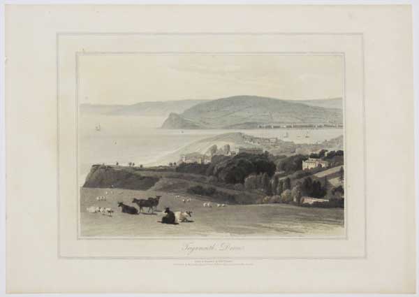
Teignmouth, Devon.
Drawn & Engraved by Will.m Daniell.
Published by W. Daniell, Russell Place, Fitzroy Square, London. May 20, 1825.
Coloured aquatint. Plate 229 x 300mm. 9 x 11¾".
A view of Teignmouth, Devon. From William Daniell's 'A Voyage Round Great Britain', a series of 308 aquatints published in eight volumes between 1814-1825, described by R.V. Tooley as 'the most important colour plate book on British Topography'. Abbey: Scenery, 16; Tooley: Books with Coloured Plates 177.
[Ref: 24179] £120.00
(£144.00 incl.VAT)
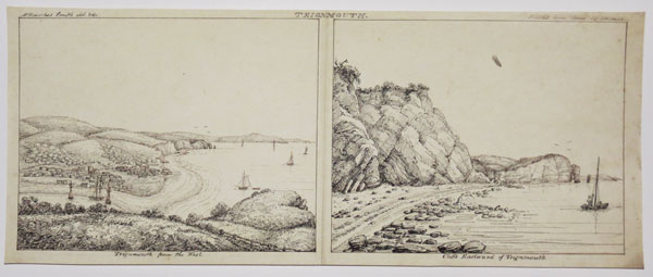
Teignmouth Teignmouth from the West. / Cliffs Eastward of Teignmouth.
W Hawkes Smith del. & fec. Printed from Stone, by WH Smith
[n.d., c.1820]
Pen and ink drawing, drawn area 185 x 430mm (7¼ x 17"). Fold through middle; unique.
Views of Teignmouth by the little-known Birmingham printmaker William Hawkes Smith (1818-1821, fl.). Ex Collection: The Late Honourable Christopher Lennox-Boyd.
[Ref: 32239] £420.00

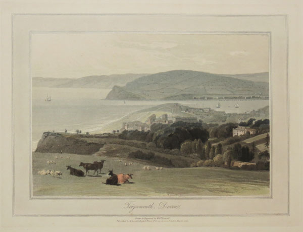
Teignmouth, Devon.
Drawn & Engraved by Will.m Daniell.
Published by W. Daniell, Russell Place, Fitzroy Square, London May 20. 1825.
Aquatint with fine original hand colour. 230 x 300mm (9 x 12"), with large margins.
A view of coastal town of Teignmouth located on the eastuary of the River Teign. From William Daniell's 'A Voyage Round Great Britain', a series of 308 aquatints published in eight volumes between 1814-1825, described by R.V. Tooley as 'the most important colour plate book on British Topography'. Abbey: Scenery, 16; Tooley: Books with Coloured Plates 177.
[Ref: 47131] £240.00
(£288.00 incl.VAT)
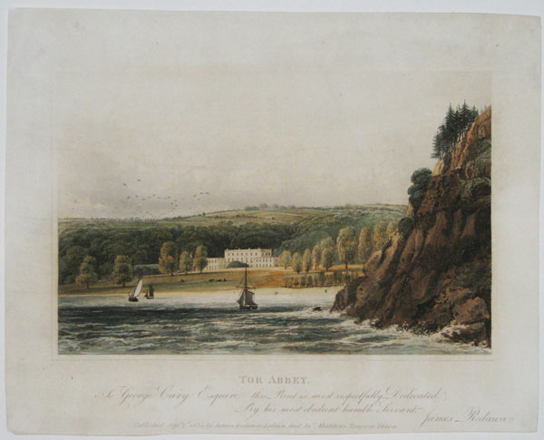
Tor Abbey. To George Cary Esquire...
Published Septr. 1st 1824, by James Redaway, London, and Jno. Matthews, Torquay, Devon.
Hand coloured aquatint, sheet 195 x 245mm. 7¾ x 9½". Trimmed within plate.
Attractive locally-published view of Torre Abbey, as seen from the sea at Tor Bay, near Torquay, south Devon. The historic house started life in 1196 as a monastery for Premonstratensian canons when William Brewer, lord of the manor of Torre, gave them the land. Not in Abbey Scenery.
[Ref: 16368] £130.00
(£156.00 incl.VAT)
Torbay
W Hawkes Smith fec. Printed from Stone, by WH Smith
[n.d., c.1820]
Lithograph, printed area 185 x 430mm (7¼ x 17"). Very rare. Slight crease on right.
View of Torbay, with key indicating (l-r) 'St. Mary church / Torquay / A singularly arched rock / Hope's Nose'. By the little-known Birmingham printmaker William Hawkes Smith (1818-1821, fl.). Ex Collection: The Late Honourable Christopher Lennox-Boyd.
[Ref: 32238] £260.00
(£312.00 incl.VAT)
Torbay, Devon.
Drawn & Engraved by Will.m Daniell.
Published by W. Daniell, Russell Place, Fitzroy Square, London, May 20, 1825.
Hand-coloured aquatint and etching, on card as issued. Plate 228 x 305mm. 9 x 12".
View from a rocky hill at Torbay, with a man and woman standing at a gate in foreground at left, on a path leading to a two-storey building overlooking the sea, with circular veranda, porch and arched doors; cliff behind. From William Daniell's 'A Voyage Round Great Britain', a series of 308 aquatints published in eight volumes between 1814-1825, described by R.V. Tooley as 'the most important colour plate book on British Topography'. Abbey: Scenery, 16; Tooley: Books with Coloured Plates 177.
[Ref: 21490] £140.00
(£168.00 incl.VAT)
Torbay.
W Hawkes Smith, del. & fec. Printed from Stone, by W.H. Smith, 1820
Original pen and ink drawing, drawn area 180 x 435mm (7¼ x 17½"). Unique.
View of Torbay with key identifying (l-r) '[St.] Mary's Church' / Torquay / Hope's Nose'. By the little-known Birmingham printmaker William Hawkes Smith (1818-1821, fl.). Ex Collection: The Late Honourable Christopher Lennox-Boyd.
[Ref: 32248] £420.00
Torbay.
W Hawkes Smith fec. Printed from Stone, by WH Smith.
[n.d., c.1820.]
Lithograph, printed area 185 x 430mm (7¼ x 17"). Crease on right & slight crease on left; very rare.
View of Torbay, with key indicating (l-r) 'Cockrington House' / St. Mary church / Torquay / Hope's Nose'. By the little-known Birmingham printmaker William Hawkes Smith (1818-1821, fl.). Ex Collection: The Late Honourable Christopher Lennox-Boyd.
[Ref: 32240] £260.00
(£312.00 incl.VAT)
St. Michael's Chapel and Torbay.
Drawn by E. Vivian. Day & Haghe, Lith.rs to the Queen.
[.n.d. c.1830.]
Rare lithograph. 318 x 419mm. 12½ x 16½".
Up on the hill sits St Michael's Chapel, dating probably from the 13th century. The cross was erected by order of the Marchioness of Bute in the early 19th century. Down in the distance sits the coatal town of Torbay, Devon.
[Ref: 18888] £160.00
(£192.00 incl.VAT)
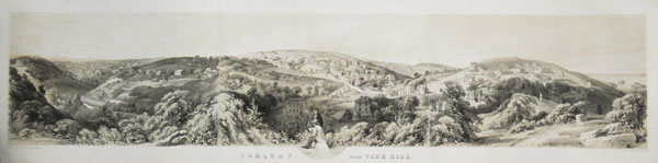
Torquay from Park Hill.
Drawn from Nature and on Stone by W. Spreat. Printed by Hullmandel & Walton.
Published by W. Spreat at No 263, High Street Exeter. [n.d, c.1840.]
Tinted lithograph on three sheets conjoined. Total printed area 230 x 950mm (9 x 37½").
A view of the rolling hills of Torquay, with the sea on the far right. Spreat seems to have included a self-portrait: at the centre are two men with drawing books. Not in Abbey.
[Ref: 31134] £490.00
view all images for this item
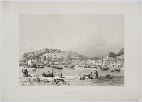
Torquay, From the Pier Head.
From Nature & on Stone by W. Spreat. Printed by W. Spreat, Exeter.
Torquay New Series No1, published by W. Spreat Exeter [n.d., c.1840]
Lithograph with tintstone, printed area 270 x 340mm (10½ x 13½"). Large margins.
Fine view of the coastal town of Torquay, with clearly identifiable buildings and numerous figures at work and rest.
[Ref: 37108] £220.00
(£264.00 incl.VAT)
Hesketh Crescent, Torquay.
J. Salter del et Lith. Day & Son, Lithrs to the Queen.
[Published by Mr J. Salter, Palk Street...] [n.d., c.1850.]
Fine & rare tinted lithograph with hand colour. Sheet 310 x 415mm (12¼ x 16¼"). Paper toned.
A view looking down on Hesketh Crescent and Meadfoot Beach. The Crescent was built in 1846 by John Tapley Harvey & William Harvey. From Salter's 'Six Views of Torquay'.
[Ref: 55479] £240.00
(£288.00 incl.VAT)


![[Drake's Island, Plymouth]](jpegs/53120.jpg)

![The North-East Prospect of Plymouth, in the County of Devon. [&] The West Prospect of His Majesties Dock-Yard, Near Plymouth.](jpegs/43058.jpg)


![[Plymouth coastal profiles.]](jpegs/13484.jpg)

![[Plymouth] To the Subscribers at Lloyds,](jpegs/51403.jpg)
![[View of the Marine Barracks at Stonehouse, near Plymouth-Dock.]](jpegs/38755.jpg)

![[Plymouth Panorama.]](jpegs/19827.jpg)
![[Set of six views in Plymouth.]](jpegs/38759.jpg)

![[A view of Plymouth sound, taken from the Rope House, Plymouth Dock]](jpegs/27845.jpg)
![[A view of Plymouth sound, taken from the Rope House, Plymouth Dock]](jpegs/38753.jpg)


![[Powderham Castle] To S.r William Courtenay Bar.t, Knight of the Shire of Devon](jpegs/52626.jpg)