Results 1-9 of 9
<<< Previous 1 Next >>>
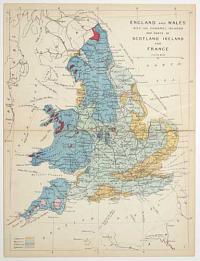
England and Wales with the Channel Islands and parts of Scotland Ireland and France.
[James Reynolds, London 1863]
Hand coloured engraving, sheet 240 x 185mm (9½ x 7¼"). Folded as issued, time staining along taped fold.
From 'Reynolds's Geological Atlas of Great Britain'. A geological map of Britain with the land colour coded by rock type.
[Ref: 56924] £30.00
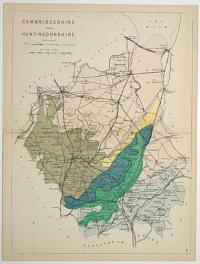
Cambridgeshire and Huntingdonshire. Railways. 4.
[James Reynolds, London 1863]
Hand coloured engraving, sheet 240 x 185mm (9½ x 7¼"). Folded as issued, time staining along fold.
From 'Reynolds's Geological Atlas of Great Britain'. A map of the railways showing ones under constuction and stations.
[Ref: 56925] £40.00
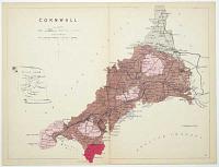
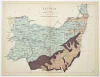
Cornwall. Railways. 6.
[James Reynolds, London 1863]
Hand coloured engraving, sheet 185 x 240mm ( 7¼ x 9½"). Folded as issued, time staining along fold.
From 'Reynolds's Geological Atlas of Great Britain'. A map of the railways showing ones under constuction and stations.
[Ref: 56926] £40.00

Essex. Railways. 13.
[James Reynolds, London 1863]
Hand coloured engraving, sheet 185 x 240mm ( 7¼ x 9½"). Folded as issued, time staining along fold.
From 'Reynolds's Geological Atlas of Great Britain'. A map of the railways showing ones under constuction and stations.
[Ref: 56927] £40.00

Middlesex Hertforshire, Bedfordshire and Buckinghamshire. Railways. 2.
[James Reynolds, London 1863]
Hand coloured engraving, sheet 240 x 185mm (9½ x 7¼"). Folded as issued, time staining along taped fold.
From 'Reynolds's Geological Atlas of Great Britain'. A map of the railways showing ones under constuction and stations.
[Ref: 56920] £40.00
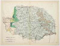
Norfolk. Railways. 21.
[James Reynolds, London 1863]
Hand coloured engraving, sheet 185 x 240mm ( 7¼ x 9½"). Folded as issued, time staining along fold.
From 'Reynolds's Geological Atlas of Great Britain'. A map of the railways showing ones under constuction and stations.
[Ref: 56921] £40.00
Suffolk. Railways. 27.
[James Reynolds, London 1863]
Hand coloured engraving, sheet 185 x 240mm ( 7¼ x 9½"). Folded as issued, time staining along fold.
From 'Reynolds's Geological Atlas of Great Britain'. A map of the railways showing ones under constuction and stations.
[Ref: 56922] £40.00

Surrey and Sussex. Railways. 28.
[James Reynolds, London 1863]
Hand coloured engraving, sheet 185 x 240mm ( 7¼ x 9½"). Folded as issued, time staining along taped fold.
From 'Reynolds's Geological Atlas of Great Britain'. A map of the railways showing ones under constuction and stations.
[Ref: 56923] £40.00
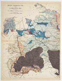
West Yorkshire and Lancashire. Railways. 18.
[James Reynolds, London 1863]
Hand coloured engraving, sheet 240 x 185mm (9½ x 7¼"). Folded as issued, time staining along fold.
From 'Reynolds's Geological Atlas of Great Britain'. A map of the railways showing ones under constuction and stations.
[Ref: 56918] £40.00
<<< Previous 1 Next >>>


