Results 1-13 of 13
<<< Previous 1 Next >>>

Algier.
[Engraved by Matthäus Merian.]
[Frankfurt c.1650.]
Engraving. 220 x 350mm (8¾ x 13¾"). Torn, creased.
A bird's-eye view of Algiers in Algeria, with the city walls, outlying forts and several galleys in the harbour. At the time the city was nominally part of the Ottoman Empire, but it was essentially independent, with piracy the main source of income.
[Ref: 30213] £180.00
(£216.00 incl.VAT)

Eigentlicher Abriss und Situation des Neuen Sterns, wie derselbe zu Regenspurg, und anderer Orthen im h. Röm. Reich den 14. 15. 16. Decembris deß 1652 Jahres, observirt und gesehen worden.
[Frankfurt, Matthaus Merian, c.1652.]
Etching. 235 x 260mm (9¼ x 10¼"). Vertical fold, tear in edge of right margin.
Four illustrations of a comet seen over Regensburg in mid-December 1652.
[Ref: 56807] £280.00
(£336.00 incl.VAT)

Diessenhoven.
[Frankfurt, Matthias Merian, 1642.]
Copper engraving. Sheet 180 x 280mm, 7 x 11". Trimmed inside to plate mark, some damage on bottom.
Plan of Diessenhofen, in the canton of Thurgau in Switzerland, published in the 'Topographia Helvetia'.
[Ref: 16474] £120.00
(£144.00 incl.VAT)

Xuntien alias Quinzay.
[Frankfurt: Matthias Merian, c.1655.]
Engraving. 180 x 255mm (7 x 10"), with very large margins.
An early map of the Chinese city of Quinzay (Hangchow), based on Marco Polo's account of China in the late 12th Century, when it was the capital of the Sung Dynasty. Polo's usual exaggerated account tells of 12,000 bridges, a massive network of canals the large 'Western Lake' 30 miles in diameter with island pavilions and palaces.
[Ref: 55450] £220.00

Heidelberga. Wahre Contafactur der Churfürstlichen Residenz Statt Heidelberg.
[Frankfurt: Matthaus Merian, c.1645.]
Engraving, 17th century watermark. Sheet 270 x 360mm (10¾ x 14¼"). Trimmed within plate, to printed border at sides.
A large view of Heidelberg from across the Neckar River, with a 13-point key.
[Ref: 57661] £280.00
(£336.00 incl.VAT)

Abriss der Dreÿen gegeneinander Correspondierenden Vestungen Monaco, Capo di Sant' Spirito und Niza di Provenza.
[Engraved by Matthias Merian.]
[Frankfurt: Merian, c.1640.]
Engraved map. Sheet 205 x 365mm (8 x 14¼"). Trimmed to printed border.
A map in the form of a bird's-eye view, looking down on Nice, Monte Carlo, Villa Franca and Saint-Jean-Cap-Ferrat, detailing their defensive walls. The map was published during the period that the Grimaldi family won recognition of the independence of Monaco, from the Spanish in 1633 and the French in 1641. Honoré II (1597-1662) was the first Prince of Monaco.
[Ref: 54245] £350.00

Moscva.
[by Matthaus Merian.]
[Frankfurt: W. Hoffmans, c.1638.]
Etched map. Sheet 270 x 355mm (10¾ x 14"). Trimmed to printed border.
A 17th century map of Moscow presented as a bird's-eye view, published in Merian's ''Newe Archontologia Cosmica''.
[Ref: 54736] £350.00

[A feast with Persians being murdered.]
[Engraved by Matthias Merian.]
[Frankfurt, Merian, c.1619.]
Rare engraving. 100 x 140mm (4 x 5½), set in German letterpress text.
An untitled classical scene, with a Graecian king at the end of the table standing up with a sword as women around the table stab their Persian guests. The surrounding text refers to Alexander the Great and Darius III of Persia but we have been unable to identify the event illustrated. From Gottfried's Historische Chronik.
[Ref: 49775] £130.00
(£156.00 incl.VAT)

Stein Am Rhein.
[Frankfurt, Matthias Merian, 1642.]
Copper engraving. Sheet 205 x 310mm, 8 x 12¼". Trimmed close to plate mark.
Plan of Stein Am Rhein, in the canton of Schaffhausen in Switzerland., published in the 'Topographia Helvetia'.
[Ref: 16479] £120.00
(£144.00 incl.VAT)

[Frontispiece to 'Topographia Sueviae' ('the topography of Swabia'), wth city view of Augsburg] Topographia Sueviae dasist Beschreib und Aigentliche Abcontrafeitung [...]
[Matthäus Merian I, 1643]
Engraving, sheet 275 x 170mm (10¾ x 6¾"). Trimmed to image; creasing.
Frontispiece to the second part of 'Topographia Germaniae' (1642-1660s), a series of volumes depicting, in thirty-eight parts, the topography of Germany.
[Ref: 46386] £60.00
(£72.00 incl.VAT)

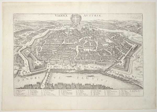
Vienna Austriae.
[Frankfurt, Matthaus Merian, 1640.]
Engraved map. 210 x 330mm (8¼ x 13"). Original binding folds as normal.
A map of Vienna in the style of a bird's-eye view, with a 42 point key. From Johann Gottfried's 'Neuwe Archontologia Cosmica'.
[Ref: 59628] £260.00

[William III's invasion fleet.] Ordnüng der See-Floot in welcher begleitung der Printz von Uranien von Hellevoet-Sluys nach Engelland abgeseegelt.
[Franfurt: Matthäus Merian, 1680.]
Engraving. 290 x 380mm (11½ x 15"). Centre fold as issued, weak impression. Wide margins top and bottom.
A plan of the formation of William III's invasion fleet in 1688 in the English Channel, part of the 'Glorious Revolution'. The towns of the south coast of England (and London) are named along the top. Underneath is a key to the ships. From ''Theatrum Europäum''.
[Ref: 54299] £320.00

Vladislaus IV. D.G. Rex Poloniæ M. Dux. Lit. Russ. Prus. Mas. Samo. Liv. Nec Non Suec. Got. Vand. Rex. etc.
[Engraved by Matthaus Merian after Peter Paul Rubens.]
[Frankfurt am Main: Merian, 1641.]
Engraving. 155 x 110mm (6 x 4¼") very large margins.
Oval portrait of Wladyslaw IV Vasa (1595-1648) wearing the Order of the Golden Fleece, based on the portrait by Rubens now in the Metropolitan Museum of Art. As well as being King of Poland and Grand Duke of Lithuania, he was also claimant to the thrones of Russia (after the Polish army captured Moscow in 1610) and Sweden.
[Ref: 57727] £190.00
(£228.00 incl.VAT)
<<< Previous 1 Next >>>