Results 1-17 of 17
<<< Previous 1 Next >>>
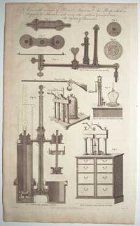
A View with sections of Princes American Air Pump which is Superior to Smeatons, and every other modern construction. See System of Pneumatics.
Blake delin.t. Lodge sculp.
Published as the Act directs, by C. Cooke No. 17 Paternoster row.
Engraving. 355 x 210mm (14 x 8¼").
Several diagrams of an air pump, as well as an illustration of an air gun. From William Henry Hall's 'The New Encyclopaedia: Or, Modern Universal Dictionary of Arts and Sciences' (text and key to plate available on Google Books').
[Ref: 61445] £120.00
(£144.00 incl.VAT)
![[American Revolution.] A New and Accurate Map of the North Carolina,](img-thumbnail/jpegs/43270.jpg)
[American Revolution.] A New and Accurate Map of the North Carolina, with the Field of Battle between Earl Cornwallis and General Gates.
Jn.o Lodge sculp.
London, Published as the Act directs, Nov.r 30th 1780, by J. Bew, Pater Noster Row.
Engraved map. Sheet 285 x 390mm (11¼ x 15½"). Trimmed close to neatline lower right for binding, folds.
A contemporary map of the theatre of the Revolutionary War in the Carolinas, published less than four months after Charles Cornwallis's route of the Continental Army under General Horatio Gates at the Battle of Camden in August 1780. Published in the 'Political Magazine', a monthly newspaper. The accompanying text is available at: https://babel.hathitrust.org/cgi/pt?id=mdp.39015067321755;view=1up;seq=479
[Ref: 43270] £480.00
![[American Revolution.] A New and Accurate Map of the Chief Parts of South Carolina, and Georgia, from the Best Authorities.](img-thumbnail/jpegs/43272.jpg)
[American Revolution.] A New and Accurate Map of the Chief Parts of South Carolina, and Georgia, from the Best Authorities.
Jn.o Lodge sculp.
London, Published as the Act directs, 30th June 1780, by J. Bew, Pater Noster Row.
Engraved map. Sheet 285 x 390mm (11¼ x 15½"). Trimmed close to neatline lower right for binding, folds.
A contemporary map of the theatre of the Revolutionary War around Charleston, as Sir Henry Clinton and Charles Cornwallis were besieging the city. Major General Benjamin Lincoln surrendered Charleston and 5,000 troops on 12th of May, less than seven weeks before this map was published. Published in the 'Political Magazine', a monthly newspaper. The accompanying text is available at: https://babel.hathitrust.org/cgi/pt?id=mdp.39015067321755;view=1up;seq=479
[Ref: 43272] £480.00
![[American Revolution.] An Accurate Map of Rhode Island,](img-thumbnail/jpegs/43271.jpg)
[American Revolution.] An Accurate Map of Rhode Island, Part of Connecticut and Massachusets, shewing Admiral Arbuthnot's Station in Blocking up Admiral Ternay.
Jn.o Lodge sculp.
London, Published as the Act directs, Nov.r 30th 1780, by J. Bew, Pater Noster Row.
Engraved map. Sheet 290 x 400mm (11½ x 15¾") Trimmed close to neatline lower left for binding, folds and some creasing.
A contemporary map of the theatre of the Revolutionary War in the Carolinas, centred on Newport, where Admiral Mariot Arbuthnot was blockading the naval forces of the 'Expédition Particulière', the Comte de Rochambeau's French army sent to help the Americans. The chevalier de Ternay died during the blockade (two weeks after this map was published), but in July the following year the French marched south to join Washington's army in the decisive Yorktown campaign. Published in the 'Political Magazine', a monthly newspaper. The accompanying text is available at: https://babel.hathitrust.org/cgi/pt?id=mdp.39015067321755;view=1up;seq=479
[Ref: 43271] £420.00
![[American Revolution.] A New and Accurate Map of the Province of New York](img-thumbnail/jpegs/43269.jpg)
[American Revolution.] A New and Accurate Map of the Province of New York and Part of the Jerseys, New England and Canada, Shewing the Scenes of our Military Operations during the present War. Also the New Erected State of Vermont.
Jn Lodge sculp.
London, Published as the Act directs, Oct.r 31st 1780, by J. Bew, Pater Noster Row.
Engraved map. Sheet 390 x 290mm (15¼ x 11½"). Trimmed to neatline lower left for binding, folds.
A contemporary map of the theatre of the Revolutionary War in the north east, from the St. Lawrence River and Lake Champlain down to Long Island and west to Lake Ontario. Despite the military subject (it marks Ticonderoga, Saratoga and Bennington) the map also shows the boundary disputes between the provinces, particularly between New York, Vermont and New Hampshire. Published in the 'Political Magazine', a monthly newspaper. The accompanying text is available at: https://babel.hathitrust.org/cgi/pt?id=mdp.39015067321755;view=1up;seq=479
[Ref: 43269] £480.00
![[American Revolution.] A New and Accurate Map of Virginia,](img-thumbnail/jpegs/43273.jpg)
[American Revolution.] A New and Accurate Map of Virginia, and Part of Maryland and Pennsylvania.
Jn.o Lodge sculp.
London, Published as the Act directs, 31st December 1780, by J. Bew, Pater Noster Row.
Engraved map. Sheet 285 x 390mm (11¼ x 15½"). Trimmed close to neatline lower right for binding, folds.
A contemporary map of the theatre of the Revolutionary War in Virginia, showing west to the Alleghany Mountains, the south parts of New Jersey and Philadelphia. The month this map was published Benedict Arnold had led a force of 1,600 troops into Virginia; less than a week later Arnold burned Richmond. Also marked on the map are events from the French-Indian Wars, including forts Duquesne & Necessity; next to Fort Necessity is ''Washington taken here 1754'', a reference to the future president's only military surrender. Published in the 'Political Magazine', a monthly newspaper. The accompanying text is available at: https://babel.hathitrust.org/cgi/pt?id=mdp.39015067321755;view=1up;seq=479
[Ref: 43273] £480.00
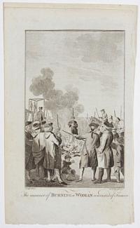
The manner of Burning a Woman convicted of Treason.
Dodd delin. J. Lodge sculp. [c.1770.]
Engraving, sheet 205 x 120mm (8 x 4¾"). Small margins on 3 sides.
Engraving published in the 'Tyburn Chronicle'.
[Ref: 46568] £65.00
(£78.00 incl.VAT)
![[Pickpocket] Jenny Diver.](img-thumbnail/jpegs/62095.jpg)
[Pickpocket] Jenny Diver.
[n.d., c.1741.]
Engraving Sheet 190 x 90mm (6 x 3½"). Trimmed within plate, laid on album paper.
Jenny Diver (née Mary Young, c.1700-41), with a watch and purse in her hands. She was a skilled pickpocker, capable of mixing in high society, and said to sometimes use fake arms so she could steal with her hands apparently in her lap. Twice she was arrested but, by using false names, was sentenced to transportation to Virginia as a first offender. Both times she bribed her way back to London. On her third arrest she was recognised and sentenced to death: as a famous criminal, she was taken to her execution in a mourning carriage.
[Ref: 62095] £160.00
(£192.00 incl.VAT)
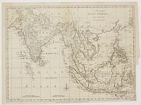
A Map of the East Indies, Drawn from the Best Authorities.
Jn.o Lodge sculp.
London, Published as the Act directs, 30th September 1780, by J. Bew, Pater Noster Row.
Engraved map. Sheet 285 x 390mm (11¼ x 15½"). Trimmed close to neatline lower right for binding, folds.
A map of the East Indies from India to the Philippines, published during the American War of Independence, Anglo-French War, Second AngloMysore War, and Fourth Anglo-Dutch War.
[Ref: 43276] £230.00
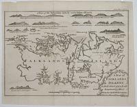
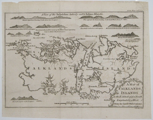
A Map of the Falkland Islands in the Latitude of 51°, 22' South, Longitude 64°, 30' West.
J. Lodge Sculp.
Gent. Mag. Oct.r 1770.
Engraving. 180 x 250mm, 7 x 9¾". Folded, as issued.
Chart of the Falkland Islands, published in the Gentleman's Magazine to accompany an account of the confrontation between the Spanish and British over possession of the islands, which nearly led to full-scale war. As it was issued only six years after the founding of the first (French) colony, it is not very accurate, with West Falkland far too wide. The coastal profiles show the rocky islands on the approaches to Saunders Island, where the British had founded Port Egmont in 1766. A decade later the British abandoned Port Egmont because of the economic pressures of the build up to the American Revolution.
[Ref: 16444] £130.00
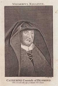
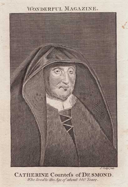
Catherine Countess of Desmond. Who lived to the Age of about 140 Years. Wonderful Magazine.
J. Lodge sculp.
[London: C. Johnson, c.1793.]
Engraving. 150 x 110mm (6 x 4¼"), large margins, with sheet of letterpress. Some spotting, old ink mss on the reverse of portrait.
A portrait supposed to be Katherine FitzGerald (c. 1504-1604), Countess of Desmond, illustrating a chapter titled 'Remarkable Instances of Longevity', published in 'The Wonderful Magazine, and Marvellous Chronicle; or New Weekly Entertainer. A work recording authentic accounts of the most extraordinary productions, events, and occurrences, in providence, nature and art. Consisting entirely of such curious matters as come under the denominations of Miraculous! Queer! Odd! Strange! Supernatural! Whimsical! Absurd! Out of the Way! and Unacountable! In 1529, she become the second wife of Thomas FitzGerald, 11th Earl of Desmond (14541534). Thomas granted her a life tenancy in Inchiquin Castle, although the title passed to her husband's male relatives. After the Desmond Rebellions the Desmond's property was granted to Sir Walter Raleigh, who allowed Katherine to stay in Inchiquin, although he was surprised how long she lived. It was Raleigh, in his History of the World, who claimed she had married in the time of King Edward IV (1461-83), making her at least 135 years old at the time of her death.
[Ref: 60812] £60.00
(£72.00 incl.VAT)
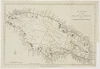
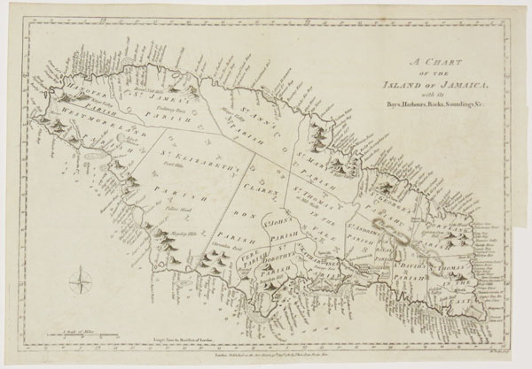
A Chart of the Island of Jamaica, with its Bays, Harbours, Rocks, Soundings &c.
Jn.o Lodge sculp.
London, Published as the Act directs, 31st August 1780, by J. Bew, Pater Noster Row.
Engraved map. Sheet 285 x 390mm (11¼ x 15½"), with 4pp. letterpress description of Jamaica. Trimmed close to neatline lower right for binding, folds.
A map of Jamaica published during the American War of Independence, which the French used as an excuse to attack British colonies in the West Indies. Although the text here relates to the economy of the island, a note states that the March issue of the 'Political Magazine' had a description of the defences.
[Ref: 43274] £175.00
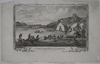
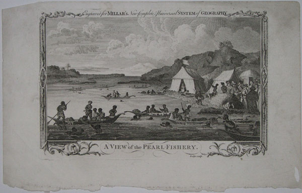
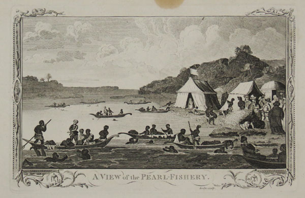
A View of the Pearl-Fishery. Engraved for Millar's New, Complete & Universal System of Geography.
Lodge sculp.
[London: A. Hogg, c.1782.]
Copper engraving, 190 x 290mm. 7½ x 11½". Creases.
Diving for pearls from pearl oysters, from rowing boats, for trade with European and other travellers, their tents to shore to right. For thousands of years, most seawater pearls were retrieved by divers working in the Indian Ocean, in areas such as the Persian Gulf, the Red Sea, and in the Gulf of Mannar (between Sri Lanka and India). In distinctive decorative border, from George Henry Millar's 'The new and universal System of Geography, being a complete history and description of the whole world. ...' 1782.
[Ref: 16687] £130.00
(£156.00 incl.VAT)
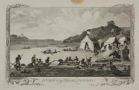
A View of the Pearl-Fishery.
Lodge sculp.
[n.d. c.1780.]
Copper engraving. Plate 190 x 292mm (7½ x 11½").
Divers collect pearl oysters from boats, while Europeans stand on the shore examining them From "Millar's New, Complete & Universal System of Geography"; London: A. Hogg, 1782.
[Ref: 24192] £75.00
(£90.00 incl.VAT)
![[The First Partition of Poland.] The Polish Plumb-Cake.](img-thumbnail/jpegs/61753.jpg)
[The First Partition of Poland.] The Polish Plumb-Cake. Thy Kingdom, Stanisl'us, is now at stake, To four such stomachs, 'tis a mere plumb-cake.
J. Lodge sculp.
[Westminster Magazine, 1st September 1774.]
Etching. 185 x 115mm (7¼ x 4½"), with separate letterpress description. Trimmed to plate upper left, laid on album paper. Otherwise small margins.
A satire on the First Partition of Poland, with the monarchs of Russia, Prussia, Austria and France sitting around a table, preparing to cut the Polish cake with swords and axes. Behind to the left is the king of Poland crying; to the right is the Ottoman Sultan, wanting to join in. Under the table is the Devil, pointing at Frederick of Prussia. The text describes Frederick as "a King more savage than an Indian". BM Satires 5229.
[Ref: 61753] £80.00
(£96.00 incl.VAT)
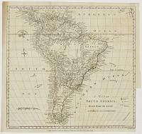
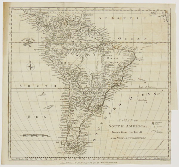
A Map of South America, Drawn from the Latest and Best Authorities.
Jn.o Lodge sculp.
London, Published as the Act directs, 31st December 1780, by J. Bew, Pater Noster Row.
Engraved map. Sheet 285 x 285mm (11¼ x 11¼"). Trimmed close to neatline lower right for binding, folds.
A map of South America published during the American War of Independence and the Fourth Anglo-Dutch War, when Britain was fighting both the French and Dutch for control of colonies in the area.
[Ref: 43275] £150.00
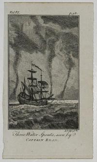
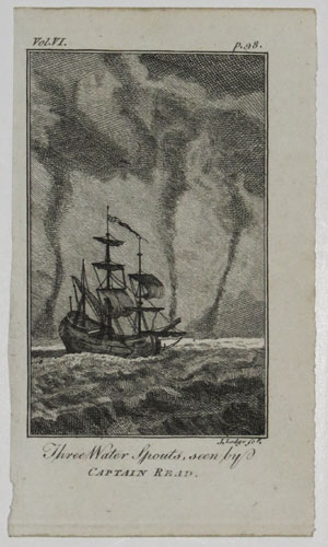
Three Water Spouts, seen by Captain Read. Vol.VI. p.98.
J. Lodge sc p.
[n.d. c.1780.]
Engraving. 140 x 82mm. 5½ x 3¼".
Waterspouts seen behind a lone ship floating on the undulating waves. The equivalent over water to tornadoes on land, however waterspouts are generally considered weaker than tornadoes.
[Ref: 25155] £60.00
(£72.00 incl.VAT)
<<< Previous 1 Next >>>

![[American Revolution.] A New and Accurate Map of the North Carolina,](jpegs/43270.jpg)
![[American Revolution.] A New and Accurate Map of the Chief Parts of South Carolina, and Georgia, from the Best Authorities.](jpegs/43272.jpg)
![[American Revolution.] An Accurate Map of Rhode Island,](jpegs/43271.jpg)
![[American Revolution.] A New and Accurate Map of the Province of New York](jpegs/43269.jpg)
![[American Revolution.] A New and Accurate Map of Virginia,](jpegs/43273.jpg)

![[Pickpocket] Jenny Diver.](jpegs/62095.jpg)

![[The First Partition of Poland.] The Polish Plumb-Cake.](jpegs/61753.jpg)