Results 1-3 of 3
<<< Previous 1 Next >>>
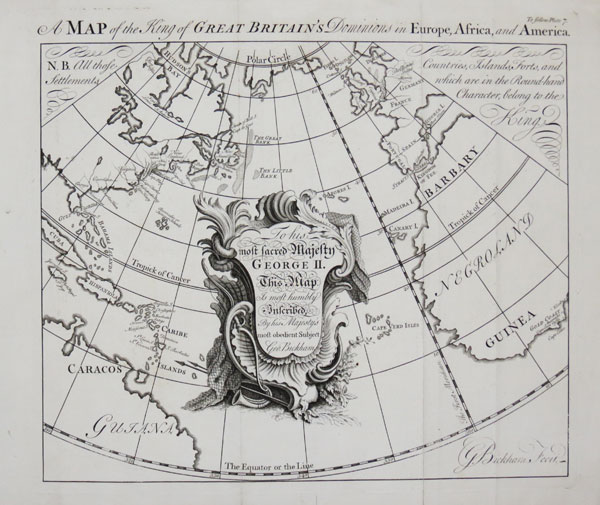
A Map of the King of Great Britain's Dominions in Europe, Africa, and America.
G. Bickham Fecit.
[n.d., 1748.]
Engraving. 280 x 315mm (11 x 12½"). Binding folds, worm holes in bottom margin.
A map centred on the Atlantic Ocean, showing from the Arctic Circle to the Equator, marking British possessions including Gibraltar, Minorca, the Gold Coast of Guinea and the colonies in North America and West Indies. From George Bickham's 'The British Monarchy or a Chorographical Description of all the Dominions Subject to the King of Great Britain'.
[Ref: 45602] £280.00
view all images for this item
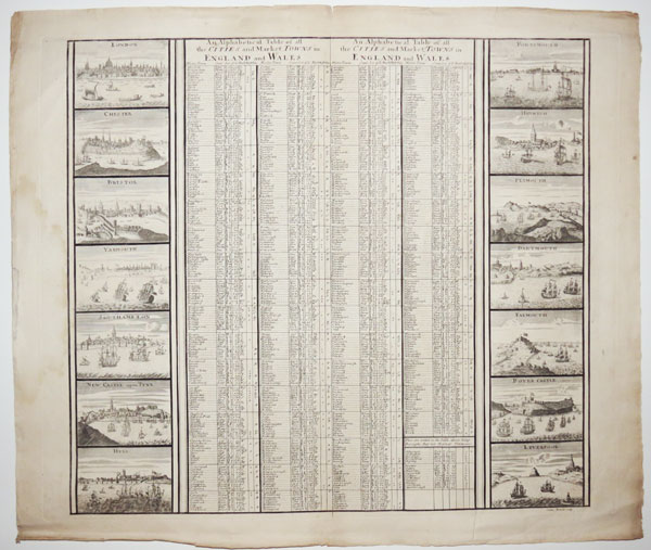
An Alphabetical Table of all the Cities and Market Towns in England and Wales.
Sutton Nicholls sculp.
[London: John Smith, c.1724.]
Engraving, rare in this pre cut state. 505 x 590mm (19¾ x 23¼"). Chips in edges.
An engraved table of market towns, edged with fourteen prospects of cities. On the left are London, Chester, Bristol, Yarmouth, Southampton, Newcastle-upon-Tyne and Hull; on the right are Portsmouth, Harwich, Plymouth, Dartmouth, Falmouth, Dover Castle and 'Leverpool'. The title is repeated because the sheet is usually bissected and pasted on the sides of 'A New Map of South Britain or England and Wales', the index map of Smith's 'Britannia Illustrata'.
[Ref: 45232] £580.00
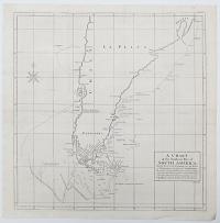
A Chart of the Southern Part of South America; With the Track of the Centurion from the Island of St Catherines to the Island of Juan Fernandes: In which is inserted the Variation and Soundings observ'd on board her, together with her Deviation from her estimated Course, occassioned by the force of the Currents.
R.W. Seale sculp.
[London: for the author by John and Paul Knapton, 1748.]
Engraved map. 530 x 500mm (20¾ x 19¾"). Folded as issued, splits in folds, paper toned.
A map of South America below Rio Grande in Brazil and Juan Fernandez Island in the Pacific (where Alexander Selkirk was marooned), marking the route taken by George Anson when rounding Cape Horn on his circumnavigation, 1740-44. The rough seas and gales meant that 'dead reckoning' was ineffective, so two estimated routes are shown south and west of the cape. On the map the Falklands have only a partial outline and, further north, the mythical 'Pepys Island', likely to be a mis-mapped Falkands, is marked. Anson's voyage was one of the last great buccaneering voyages, an official expedition to the South Seas to harass the Spanish bases but, more importantly, plunder their shipping. A main target was one of the richly-laden Manila galleons that crossed between Acapulco in Mexico and Manilla the Philippines. A stroke of luck presented them with one laden with 1.3 million silver pieces of eight; on their return to London, thirty-two wagons were needed to transfer them to the Tower of London. Published in Anson's own account, ''A Voyage Round the World, in the years MDCCXL, I, II, III, IV''.
[Ref: 43989] £350.00
<<< Previous 1 Next >>>