Results 1-10 of 10
<<< Previous 1 Next >>>
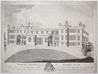
Audley House commonly call'd Audley End The Seat of Sir John Griffin Griffin Colonel of the First Troop of Horse Grenadier Guards, Lieut.t General of his Majestys Forces and Knight of the most Honourable Order of the Bath.
J. Hobcraft D. J. Austin Sc. [c.1765]
Rare engraving; platemark 340 x 465mm (13¼ x 18¼"). Messy.
Audley End House, Essex. Built by Thomas Howard, first earl of Suffolk c.1605-14, the house was transformed by the great Palladian architect Robert Adam for its then-owner, soldier Sir John Griffin Griffin in the 1760s (as shown here). The property is now maintained by English Heritage.
[Ref: 44833] £280.00
(£336.00 incl.VAT)
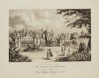
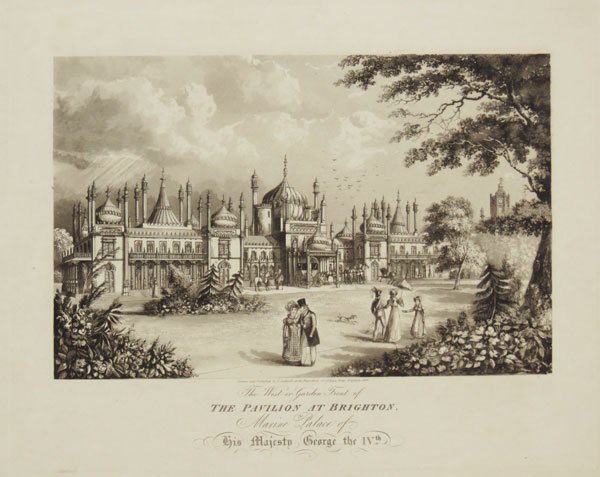
The West or Garden Front of The Pavilion at Brighton, the Marine Palace of his Majesty, George IVth.
[Engraved by T.Sutherland.]
Drawn and Published by J. Cordwell, at his Repository, 20 Great East Street, Brighton, 1824.
Aquatint, fine impression. 290 x 350mm (11½ x 13¾") very large margins.
View of the back entrance of the Royal Pavilion at Brighton, as re-designed by John Nash between 1815-1822. Although the exterior was in the Indo-Saracenic style the interiors were in the most extravagant chinoiserie style ever executed in the British Isles. This example lacks the engraver's name. Ford: Images of Brighton, 538.
[Ref: 44556] £180.00
(£216.00 incl.VAT)
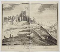
Dover Castle. Le Chateau de Douvre.
I. Sailmaker Delin: H. Hulsbergh Sculp:
Printed & Sold by H: Overton at ye White Horse w.th out Newgate London. [but published by John Smith, 1724.]
Engraving. 475 x 595mm (18¾ x 23½")/ Fold as issued. Small margins.
A view of Dover Castle, with the town and Dover Roads to the right. This example comes from the 'Britannia Illustrata', 1724.
[Ref: 44520] £360.00
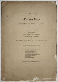
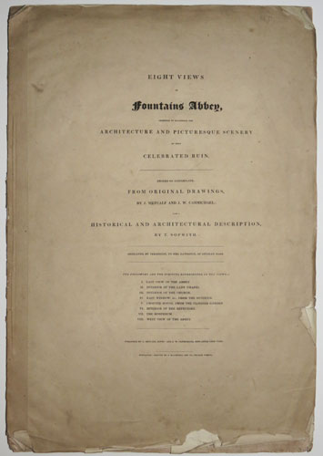
Eight Views of Fountains Abbey Intended to Illustrate the Architecture and Picturesque Scenery of that Celebrated Ruin.
Etched on Copperplate from Original Drawings, by J. Metcalf and J.W. Carmichael: with a Historical and Architectural Description by T. Sopwith.
Published by J. Metcalf, Ripon: and J.W. Carmichael, Newcastle upon Tyne. Newcastle: Printed by J. Blackwell and Co. Pilgrim Street. [1832.]
Bound set of 8 etchings in wrappers. Rare artist's presentation copy. In ink on Frontis "To Miss Hodge with Mr. Carmichael compliments" Folio: 380 x 550mm (15 x 21¾") very large margins. Uncut. Edges torn and creased.
A bound series of eight etchings of Fountains Abbey, views include 'East View of the Abbey', 'Interior of the Lady Chapel', 'Interior of the Church','East Window from the Interior', 'Chapter House from the Cloister Garden', 'Interior of the Refectory', 'The Hospitum' and 'West View of the Abbey'. Some scenes etched after drawings by James Wilson Carmichael (1800-1868). Abbey Scenery: 373
[Ref: 44886] £360.00
view all images for this item
![[Holdenby House.]](img-thumbnail/jpegs/44670.jpg)
[Holdenby House.]
[n.d., c.1800.] Watercolour. Sheet: 240 x 200mm (9½ x 8").
A view of the ruins of Holdenby House near Northampton, originally built in 1583 the house was destroyed during the civil war but was rebuilt between 1873-78. This painting shows the ruins of the house before it was rebuilt.
[Ref: 44670] £350.00

Reasons in Favour of the Bill, For making and maintaining a Turnpike Road, from or near the Town of Manchester, in the County of Lancaster, to Hyde-lane Bridge, in the County of Chester. [with map] Plan of an Intended Turnpike Road from near Manchester to Hyde Lane Bridge.
Sharpe, Eccles & Cririe, Solicitors. Dorington Agent.
Printed by J. Aston, at the Exchange-Heral-Office, St Ann's Street, Manchester. [n.d., c.1822.]
Pamphlet, single sheet of letterpress, 390 x 320mm (15½ x 12½") folded, folding map with original colour stitched in. Map 250 x 270mm (9¾ x 10½") Contemporary ink on cover, map with ink offset.
A plan to build a more direct road from Manchester to Hyde, where there were 40 cotton mills in operation. Hyde is now part of Greater Manchester. The style of the map suggests it was engraved by John Cary.
[Ref: 44733] £80.00
view all images for this item
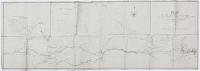
Plan of the Intended Coast Road from near St. Austell to Torpoint through Fowey and Looe showing the present circuitous and hilly Road through Liskeard and Lostwithiel Surveyed under the directions of Ja.s M. Rendel Civil Engineer 1834
Hackett, lithog.d, 15, Paris Street, Exeter
Scarce lithographic map with hand-colouring, backed onto linen, printed area approx. 715 x 2150mm (28¼ x 84¾")
Very large map showing the area between Plymouth and St. Austell in Cornwall on the south coast of England, and north as far as Liskeard. The map shows the proposed coastal road between St. Austell and Torpoint (across the river Tamar from Plymouth) and was surveyed under the direction of the renowned civil engineer James Meadow Rendel (1799-1856). Rendel was born near Okehampton in Devon and, after working for Thomas Telford, set up his own practice in Plymouth in 1822. Rendel's bridge across an estuary of the Plym within Plymouth harbour (completed 1827) established him as a leader of contemporary bridge design, and in the 1830s Rendel's reputation was such that he was involved in the improvement and development of practically every river and harbour in south-west England. In 1838 he moved to London and thereafter took on projects in the north of England and Scotland and, in the 1850s, countries including South Africa, India and Brazil. For a portrait of Rendel see ref. 22531.
[Ref: 44479] £650.00
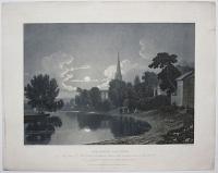
Stratford upon Avon. The grave of Shakespeare is situated between the windows seen in the church. ''His good remembrance lies richer in your thoughts, than on his tomb.''
G.F. Robson del.t. W.J. Bennett sculp.t.
London Published Jan.y 20, 1822, by S. & I. Fuller, at the Temple of Fancy, 34 Rathbone Place.
Aquatint, rare. Sheet: 500 x 400mm (19¾ x 15¾"). Trimmed within plate. Marking in margins.
A moonlit scene in looking up the Avon to the church at Stratford-upon-Avon where William Shakespeare is buried. He died on 23rd April 1616.
[Ref: 44880] £350.00
![[Theobalds.]](img-thumbnail/jpegs/44671.jpg)
[Theobalds.]
[n.d., c.1800.]
Fine watercolour. Sheet: 240 x 175mm (9½ x 7"). Glued to album sheet. Unfaded.
A watercolour of some of the buildings built in the grounds of Theobalds Palace, built by Sir William Cecil and destroyed in 1651 by Parliament. Several other buildings were built on the estate in the following centuries.
[Ref: 44671] £350.00
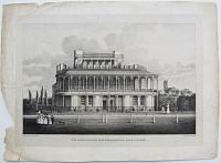
The Grand Stand. Wolverhampton Race Course.
R. Noyes. Printed by C. Hullmandel.
[n.d., c.1830.]
Very rare lithograph, on india. 280 x 400mm (11 x 15¾"). Margins damaged.
A view of the Wolverhampton Race Course at the old ground in West Park. The racecourse was established in 1825 and the grand stand was built in 1827, from after plans by Mr Vulliamy. The racecourse was eventually moved to its current site in Dunstall Park in the 1880s. St. Peters Church can be seen in the distance. After Robert Noyes (1780-1843).
[Ref: 44466] £220.00
(£264.00 incl.VAT)
<<< Previous 1 Next >>>


![[Holdenby House.]](jpegs/44670.jpg)


![[Theobalds.]](jpegs/44671.jpg)
