Results 1-30 of 30
<<< Previous 1 Next >>>
![[Sketch Map.] Dominion of Canada.](img-thumbnail/jpegs/48595.jpg)
[Sketch Map.] Dominion of Canada. Albert Railway of New Brunswick.
Lithographic map. Sheet: 440 x 540mm (17¼ x 21¼''). Creasing and folds as issued.
A map of the Albert Railway in the area around the Bay of Fundy. Towns marked include Salisbury, Alma, Harvey and Greenville.
[Ref: 48595] £130.00
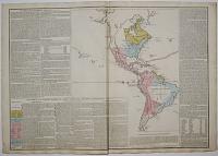
Geographical Map of America.
Printed by R. Juigné, 17, Margaret Street, Cavendish Square. [n.d., c.1817.]
Hand coloured engraving with surrounding letter press text and large margins. Sheet size: 495 x 715mm (19½ x 28¼").
A map of North America, surrounded by letterpress descriptions, published in an English edition of Le Sage's Historical Atlas. On the map the routes of Columbus and Pizarro are marked and the possessions of the English, United States, Spanish & Portuguese are delineated in colour.
[Ref: 36874] £330.00
![[American Revolution.] An Accurate Map of Rhode Island,](img-thumbnail/jpegs/43271.jpg)
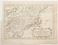
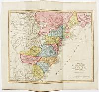
[American Revolution.] An Accurate Map of Rhode Island, Part of Connecticut and Massachusets, shewing Admiral Arbuthnot's Station in Blocking up Admiral Ternay.
Jn.o Lodge sculp.
London, Published as the Act directs, Nov.r 30th 1780, by J. Bew, Pater Noster Row.
Engraved map. Sheet 290 x 400mm (11½ x 15¾") Trimmed close to neatline lower left for binding, folds and some creasing.
A contemporary map of the theatre of the Revolutionary War in the Carolinas, centred on Newport, where Admiral Mariot Arbuthnot was blockading the naval forces of the 'Expédition Particulière', the Comte de Rochambeau's French army sent to help the Americans. The chevalier de Ternay died during the blockade (two weeks after this map was published), but in July the following year the French marched south to join Washington's army in the decisive Yorktown campaign. Published in the 'Political Magazine', a monthly newspaper. The accompanying text is available at: https://babel.hathitrust.org/cgi/pt?id=mdp.39015067321755;view=1up;seq=479
[Ref: 43271] £420.00
![[American Revolution.] A New and Accurate Map of the Province of New York](img-thumbnail/jpegs/43269.jpg)
[American Revolution.] A New and Accurate Map of the Province of New York and Part of the Jerseys, New England and Canada, Shewing the Scenes of our Military Operations during the present War. Also the New Erected State of Vermont.
Jn Lodge sculp.
London, Published as the Act directs, Oct.r 31st 1780, by J. Bew, Pater Noster Row.
Engraved map. Sheet 390 x 290mm (15¼ x 11½"). Trimmed to neatline lower left for binding, folds.
A contemporary map of the theatre of the Revolutionary War in the north east, from the St. Lawrence River and Lake Champlain down to Long Island and west to Lake Ontario. Despite the military subject (it marks Ticonderoga, Saratoga and Bennington) the map also shows the boundary disputes between the provinces, particularly between New York, Vermont and New Hampshire. Published in the 'Political Magazine', a monthly newspaper. The accompanying text is available at: https://babel.hathitrust.org/cgi/pt?id=mdp.39015067321755;view=1up;seq=479
[Ref: 43269] £480.00
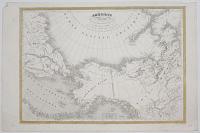
Amérique Boreale pour servir à l'Histoire des dernieres découvertes.
Gravé sur Acier par Laguillermie, Rue de Noyers, no 55.
Imprimé par Mangeon. [Paris, 1837.]
Etched map with some outline colour. Printed area 330 x 470mm, 13 x 18½". Slight crease on left; edges knocked.
Map of Arctic America, published in Montemont's 'Histoire Universelle des Voyages', with Alaska still marked as Russian (a boundary line shows the limits of Russian and British territory under a treaty of 1825). Designed to show 'new discoveries', there is evidence of re-engraving in the Nunavut region of Canada.
[Ref: 27655] £230.00
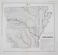
Arkansas.
[n.d, c.1854.]
Engraved map. 420 x 450mm, 16½ x 17¾" With blind stamp of the Manchester Free Library, trimmed lower left for binding.
Prepared for the 33rd Congess of the United States.
[Ref: 26833] £190.00
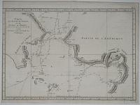
Carte de l'Entrée de Norton, et du Détroit de Bhering ou l'on voit le Cap le plus Oriental de L'Asie, et la Pointe la plus Occidentale de L'Amerique.
Benard direxit.
[Paris 1787.]
Engraving. 280 x 390mm (11 x 15¼"). Trimmed.
Chart of the Bering Strait and Norton Sound, Alaska, showing the two attempts of Captain Cook's ship to penetrate the Straits on his third & final voyage, 1778-79. After his discovery of Hawaii Cook sailed north along the west coast of America, looking for the North West Passage. Having passing through the Bering Strait only to be blocked by the Arctic ice, he returned to Hawaii and was murdered in 1779. Afterwards the expedition, under the command of Captain Clerke, made a final attempt on the Bering Strait. Engraved by Bénard for a French edition of the Official Account of Cook's Voyages.
[Ref: 13528] £65.00
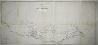
Map of the Public Surveys in California to accompany Report of Surveyor Gen.l 1854.
P.S. Duval & Co's Steam Lith. Press. Phila.
Surveyor General's Office, San Francisco, Calif., Sept. 28th, 1854, Approved John C. Hays, U.S. Sur. Gen.l Cal.
Lithographic map. Printed area 510 x 1160mm, 20 x 41¾". Trimmed lower left for binding, splits at folds, some slight loss, damaged.
A detailed survey of the environs of San Francisco, prepared for the 33rd Congess of the United States, which was working on controlling the settlement of new territories.
[Ref: 26825] £320.00
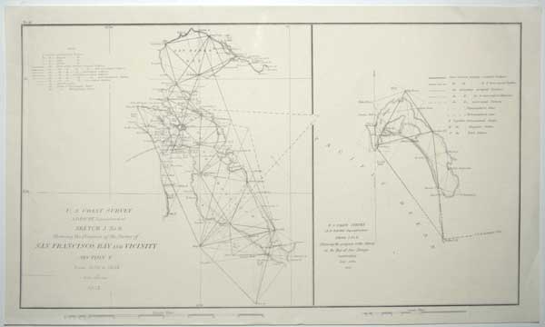
U.S. Coastal Survey. A.D. Bache Superintentent. Sketch J. No. 6, Showing the Progress of the Survey of San Francisco Bay and Vicinity. Section X. From 1850 to 1853. Scale 1/400,000 1853. ... Showing the Progress of the Survey in the Bay of San Diego California. Scale 1/200,000. 1853.
[Washington, 1854.]
Engraved map. Sheet 255 x 430mm (10 x 17"). With original binding folds.
A sheet with two charts from early trigonometrical surveys for the U.S. Coastal Survey under Alexander Dallas Bache (grandson of Benjamin Franklin).
[Ref: 57714] £140.00
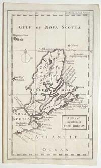
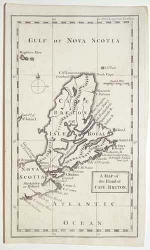
A Map of the Island of Cape Breton.
[n.d., July 1758.]
Rare engraving. 200 x 120mm (8 x 4¾"). Trimmed within plate on left.
A map of Cape Breton, marking Louisburg and where the English landed in June 1758, published in the 'Grand Magazine of Magazines', to illustrate an account of English attacks during the 'French and Indian War', the North American theatre of the 'Seven Years' War'. The French fortress of Louisbourg was captured in 1758, prior to the Siege of Quebec by James Wolfe. The first issue of the 'Grand Magazine' was in July 1758; it ceased publication after the November 1759 issue.
[Ref: 55703] £180.00
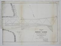
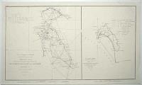
Sketch of Monroe Harbor Showing the Extent of Repairs made in 1853 & 1854 and the Condition of the Harbor on the 30th Sept 1854. Under the Direction of Captain Howard Stansbury Corps of Topog.l Eng.rs General Superint.dt.
D. Chillas, Lith, 50 S. 3d St Phil.a.
[n.d., c.1854.]
Lithographic map. Printed area 400 x 560mm, 15¾ x 22". Trimmed lower left for binding, splits at folds. Blind stamp of the 'Mancheste Free Library' in title.
Monroe Harbor in Chicago, with docks and the Southern Michigan & Northern Indiana Rail Road, with their freight and passenger houses, a turn table and engine house. Prepared for the 33rd Congess of the United States, who would have been funding the repair work, with a facsimile signature of Howard Stansbury, best-known for his survey of the Great Salt Lake in Utah in 1849.
[Ref: 26826] £150.00
![[Three survey maps of Erie Harbor.] West End of Erie Harbor showing the Breach inthe Sand-bar 1854 [&]](img-thumbnail/jpegs/26834.jpg)
[Three survey maps of Erie Harbor.] West End of Erie Harbor showing the Breach inthe Sand-bar 1854 [&] West End. Erie August 1854 [&] East End. Erie, August, 1854.
D. Chillas Lith 50 So. 3rd St. Philad.a. [&] P.S. Buval & Co's Steam Press P.la.
[n.d, c.1854.]
Three lithographic maps. 300 x 430mm, 12 x 17", 340 x 470mm, 13¼ x 18¼", & 300 x 400mm, 12 x 15¾". Each with blind stamp of the Manchester Free Library, trimmed lower left for binding, damp stains.
Three sketch survey maps of the harbour of Erie, Pennsylvania. Prepared for the 33rd Congess of the United States.
[Ref: 26834] £160.00
view all images for this item
Carte de la Baye de Hudson. Pour servir à l'Histoire Generale des Voyages.
Par M. B. [Bellin] Ing.r de la Mar.e 1757.
[Paris: Didot Libraire, c.1757.]
Engraved map, 18th century watermark. 235 x 315mm (9¼ x 12½"). Narrow right margin, binding folds, slight damp staining.
A map of Hudson Bay and Newfoundland. A note in French top left states that 'the England search for a [North West] passage here but it doesn't exist'. Published in Prevost's 'Histoire Generale des Voyages'.
[Ref: 59459] £130.00
![Sketch of the Public Surveys in Iowa. [&] Harbor of Dubuque.](img-thumbnail/jpegs/26830.jpg)
Sketch of the Public Surveys in Iowa. [&] Harbor of Dubuque.
D. Chillas Lith 50 So. 3rd St. Philad.a.
[n.d, c.1854.]
Two lithographic maps. 440 x 520mm, 17¼ x 20½, & 370 x 290mm, 14½ x 11½". Iowa map tear at binding fold; Dubuque map trimmed for binding. Both with blind stamp of the Manchester Free Library
A map of the state of Iowa and a plan of the proposed bridge for the Central Rail Road of Illinois over the Mississippi at Dubuque, prepared for the 33rd Congess of the United States.
[Ref: 26830] £220.00
view all images for this item
![[Four surveys of the Lake Ontario coasts of New York State.]](img-thumbnail/jpegs/26828.jpg)
[Four surveys of the Lake Ontario coasts of New York State.] Oswego Harbor. [&] Sketch of the Entrance of Sodus Bay, Cayuga County Showing the work done in 1854 by W. Turnbull, Major Top.l Eng.rs... [&] Survey of the Entrance of Little Sodus Bay Cayuga County N.Y. by W. Turnbull... [&] Sodus Bay Wayne Co. N.Y. 1854.
Wagner & McGuigan Lith. Phil.a.
[1854.]
Four lithographic maps, largest 300 450mm, 12 x 17¾". Some age-toning, blind stamp of the Manchester Free Library on all sheets.
Four plans of works undertaken by the Fedeal Government, prepared for the 33rd Congess of the United States.
[Ref: 26828] £230.00
view all images for this item
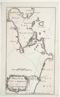
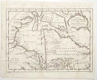
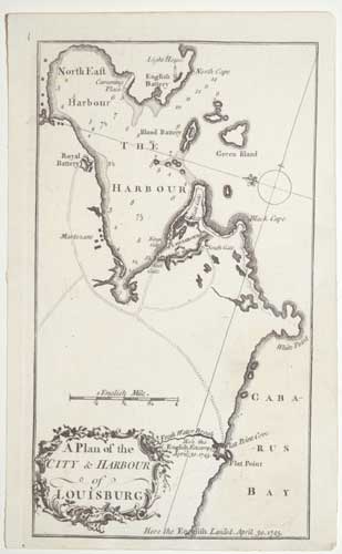
A Plan of the City & Harbour of Louisburg.
[n.d., August 1758.]
Rare engraving. 200 x 120mm (8 x 4¾"). Trimmed within plate right and bottom.
A plan of the environs of the French fortress of Louisbourg, published in the 'Grand Magazine of Magazines', to illustrate an account of English attacks during the 'French and Indian War', the North American theatre of the 'Seven Years' War'. The fortress was captured by a New England army backed by the Royal Navy in 1745, part of the 'War of the Austrian Succession'. Returned to French possession at the end of the war, it was attacked again unsuccessfully in 1757 and finally in 1758, prior to the Seige of Quebec by James Wolfe. The first issue of the 'Grand Magazine' was in July 1758; it ceased publication after the November 1759 issue.
[Ref: 55702] £180.00
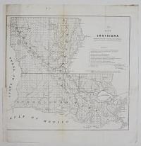
Map of Louisiana Representing the Seveal Land Districts. Prepared to accompany the Surveyor General's annual Report.
[n.d, c.1854.]
Engraved map. 420 x 460mm, 16½ x 18" With blind stamp of the Manchester Free Library, trimmed lower left for binding.
Prepared for the 33rd Congess of the United States.
[Ref: 26832] £190.00
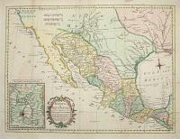
Mexico of Nieuw Spanje; tot het nagaan der vorderingen van Cortes. Tot Dr Robertson's Seschiedenisvan vam America. Door Thom.s Kitchin Sen.r Kaartmaaker zyner Britt. Majesteit.
A. v. Krevelt, sculps. Amsterd. 1778.
[Amsterdam, 1778.]
Engraved map with hand colouring. 290 x 400mm, very large margins. Original binding folds.
A map of the American south-west, with 'Tecas' (Texas) and New Mexico. From a Dutch edition of Dr. Robertson's 'History of America'.
[Ref: 57637] £250.00
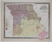
Swallow's Geological Map of Missouri. Engraved expressly for Campbell's Sectional, Topographical & Descriptive Atlas of the State.
Steam Lith Print by Gast & Co., St Louis.
Entered according to Act of Congress in the year 1872 by R.A.Campbell, in the Office of the Librarian of Congress in Washington.
Engraving. 300 x 360mm, 12 x 14¼".
Map of the geology of Missouri by George Clinton Swallow, Professor of Geology and Agriculture in the State University of Missouri.
[Ref: 19985] £95.00
![[Map used for the KansasNebraska Act.]](img-thumbnail/jpegs/26824.jpg)
[Map used for the KansasNebraska Act.]
[The Congressional Record, n.d., c.1855.]
Lithographic map. Printed area 460 x 300mm, 18 x 12". Trimmed lower left for binding, wear at folds, blind stamp of the 'Manchester Free Library 1851' in map area. Creases as normal.
A map of the proposed boundary between the new territories of Kansas and Nebraska, prepared for the Kansas-Nebraska Act of 1854, and published in the Congressonal Record. 'The Kansas-Nebraska Act' was one of the milestones en route to the American Civil War: when the territories were opened up for settlement it was decided to give them a free vote about whether to allow slavery or not. Agitators for both sides poured in, including the infamous John Brown and his sons, who murdered five pro-slavery farmers with a broadsword. The dispute also split the traditional political parties, the Democrats & Whigs, with the dissenters turning to the naisant Republicans. The major political camps were now divided geographically, Republicans for the North and Democrats for the south.
[Ref: 26824] £240.00
Carte de la Nouvelle Angleterre Nouvelle Yorck et Pensilvanie. Pour servir à l'Histoire Generale des Voyages.
Par M. B. [Bellin] Ing. de la Mar.e 1757.
[Paris: Didot Libraire, c.1757.]
Engraved map, 18th century watermark. 220 x 310mm (8½ x 12¼"). Trimmed to plate upper left by binder, folds with a small tear, 8 worm holes in image.
A map of the Eastern Seaboard from Delaware Bay north to Penobscot, and west to Lake Erie. Published in Prevost's 'Histoire Generale des Voyages'.
[Ref: 59458] £250.00
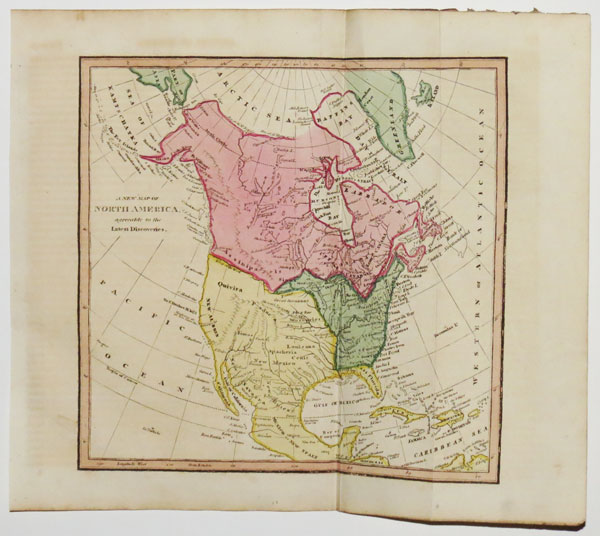
A New Map of North America, agreeable to the Latest Discoveries.
[engraved by Thomas Conder.]
[London & Edinburgh: Richard Evans & John Bourne, 1817.]
Hand-coloured engraved map. 220 x 230mm (8¾ x 9"). With original binding folds.
A map of North America, published in an edition of William Robertson's 'History of America'. The map was originally published in a 1794 edition by Robert Wilkinson, but the only changes seem to be the removal of the publication line and Conder's name. The cartography still predates Vancouver's voyage, with the 'River of the West' still marked, as is 'West Florida', the British possession already under U.S. control.
[Ref: 47823] £200.00
![North America Drawn from the best Authorities By T. Kitchin [decorative cartouche].](img-thumbnail/jpegs/3586.jpg)
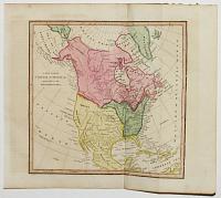
North America Drawn from the best Authorities By T. Kitchin [decorative cartouche].
[n.d. c.1784].
Engraved map. 200 x 230mm. Folded as issued in volume, with tears along platemark and into map.
For the Modern Universal British Traveller. Thomas Kitchin [1718 - 1784] worked as a publisher and engraver from premises at The Star in Holborn, London. He produced a large number of maps of every kind for periodical, such as the London Magazine, and for books on history and antiquities. He is probably best known though, for his partnership with Emanuel Bowen with whom he published, in 1755, 'The Large English Atlas' which contained the finest county maps of the 18th.Century.
[Ref: 3586] £110.00
![[Seven maps of Ohio harbour surveys.]](img-thumbnail/jpegs/26831.jpg)
[Seven maps of Ohio harbour surveys.] Sketch of Huron Harbor [&] Ashtabula Harbor Ohio [&] Conneaut Harbor Ohio [&] From Captain Stansbury's Survey of the Harbor of Cleveland, Ohio 1853; Sketch of the Harbour of Black River [&] Grand River Harbor Ohio 1854 [&] Survey of the Harbor of Cleveland Ohio...
Wagner & McGuigan, Lith Phila. [&] D. Chillas Lith 50 So. 3rd St. Philad.a.
[n.d, c.1854.]
Seven lithographic maps. Largest 450 x 615mm, 17¾ x 24¾". All with blind stamp of the Manchester Free Library. A few splits to folds, paper toning.
Surveys for a report on the condition of harbours in Ohio, prepared for the 33rd Congess of the United States.
[Ref: 26831] £300.00
view all images for this item
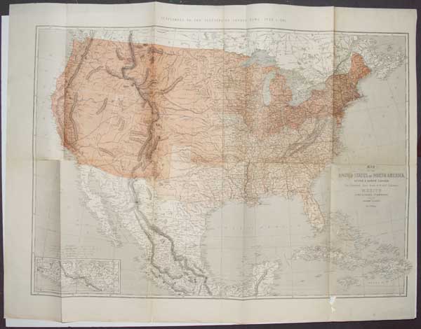
United States of North America. (Eastern & Central) By T. Ettling.
Weekly Dispatch Atlas, 139 Fleet Street. Drawn & Engraved by T. Ettling 3 Red Lion Square, Holborn.
Day & Son Lith.rs to The Queen. [n.d. c.1860.]
Lithograph with original outline colour. 495 x 350mm. 19½ x 13¾". Crease and staining.
One of the 24 sections of a map of the United Sates of Nother America. A British separately issued map of the United States up to the Rockies by Theodor Ettling. Ettling was a Dutch draughtsman, engraver and lithographer who worked first in Amsterdam, later moving to London where he produced maps for some of the British papers of the mid-nineteenth century. This map was published by the Weekly Dispatch, which issued an atlas in 1858 with maps by Ettling. Ettling seems to have made quite a study of North America, issuing a number of fine examples such as this large folding map. Detail is copious and precisely delineated in a typically neat British style. Roads, towns, rivers, lakes, and topographically are all accurately and clearly rendered. The map shows the United States as it was situated at the beginning of the Civil War, includes the Bahamas and part of Cuba.
[Ref: 25035] £140.00
A Map of the United States of America, with Part of the Adjoining Provinces from the latest Authorities.
[engraved by Thomas Conder.]
[London & Edinburgh: Richard Evans & John Bourne, 1817.]
Hand-coloured engraved map. 220 x 230mm (8¾ x 9"). With original binding folds.
A map of the United States, published in an edition of William Robertson's 'History of America'. The map was originally published in a 1794 edition by Robert Wilkinson: for this state 'Tenessee' has been added, and the publication line and Conder's name removed. Elsewhere 'West Florida', the British possession already under U.S. control is still marked.
[Ref: 47824] £350.00
Map of the United States of North America, Upper & Lower Canada, New Brunswick, Nova Scotia & British Columbia, Mexico, Cuba, Jamaica, St Domingo and the Bahama Islands.
By T. Ettling.
Supplement to The Illustrated London News, June 1st 1861.
Wood engraving with colour printing. Printed area 780 x 920mm (30¾ x 36¼"). Splits in binding folds.
A map of the United States of America at the outbreak of the Civil War, with the states colour-coded to differentiate between Union and Confederacy. The day of issue, June 1st 1861, the Federal Army entered Virginia.
[Ref: 57402] £280.00
Carte de la Baye de Chesapeack et Pays Voisins. Pour servir à l'Histoire Generale des Voyages. Tirée des meilleures Cartes Angloises.
[Nicolas Bellin.]
[Paris: Didot Libraire, c.1757.]
Engraved map. 210 x 305mm (8¼ x 12"). Trimmed to plate lower right by binder, folds, two worm holes in image.
A map of the environs of Chesapeake Bay, with Virginia, Maryland and part of New Jersey. Published in Prevost's 'Histoire Generale des Voyages'.
[Ref: 59457] £260.00
Carte du Golphe du Mexique et des Isles de l'Amerique. Pour servir à l'Histoire Generale des Voyages.
Par M. Bellin Ing.r de la Mar.e 1754.
[Paris: Didot Libraire, c.1757.]
Engraved map with hand colour, 18th century watermark; 290 x 390mm (11½ x 15¼"). Narrow right margin, binding folds, 16 worm holes.
A map of the West Indies and Gulf of Mexico. It marks the mythical island of Bermeja off Yucatan, belief in which lasted until quite recently but not found in a survey in 2009. A current conspiracy theory in Mexico claims that the Central Intelligence Agency destroyed the island to expand the economic zone allotted to the United States. Published in Prevost's 'Histoire Generale des Voyages'.
[Ref: 59460] £480.00
![[Six survey map of Wisconsin.] Sketch of the Public Surveys in Wisconsin and Teritory of Minnesota.](img-thumbnail/jpegs/26837.jpg)
[Six survey map of Wisconsin.] Sketch of the Public Surveys in Wisconsin and Teritory of Minnesota. [&] Plan and Section of the North Cut at Milwaukee No. 2 [&] Entrance to Kenosha Harbor [&] Copy of Plate of Kenosha Harbor [&] Harbor of Manitowoc Wis. [&] Plan of Racine Harbor.
D. Chillas Lith 50 So. 3rd St. Phil.a.
[n.d, c.1854.]
Engraved state map and five lithographed maps of harbours. largest (state map) 470 x 560mm, 18 x 22". Each with blind stamp of the Manchester Free Library, state map trimmed lower left for binding, damp stains and toning.
Six survey maps of the state of Wisconsin, prepared for the 33rd Congess of the United States.
[Ref: 26837] £360.00
view all images for this item
<<< Previous 1 Next >>>
![[Sketch Map.] Dominion of Canada.](jpegs/48595.jpg)

![[American Revolution.] An Accurate Map of Rhode Island,](jpegs/43271.jpg)
![[American Revolution.] A New and Accurate Map of the Province of New York](jpegs/43269.jpg)


![[Three survey maps of Erie Harbor.] West End of Erie Harbor showing the Breach inthe Sand-bar 1854 [&]](jpegs/26834.jpg)

![Sketch of the Public Surveys in Iowa. [&] Harbor of Dubuque.](jpegs/26830.jpg)
![[Four surveys of the Lake Ontario coasts of New York State.]](jpegs/26828.jpg)


![[Map used for the KansasNebraska Act.]](jpegs/26824.jpg)

![North America Drawn from the best Authorities By T. Kitchin [decorative cartouche].](jpegs/3586.jpg)
![[Seven maps of Ohio harbour surveys.]](jpegs/26831.jpg)


![[Six survey map of Wisconsin.] Sketch of the Public Surveys in Wisconsin and Teritory of Minnesota.](jpegs/26837.jpg)