Results 1-31 of 31
<<< Previous 1 Next >>>
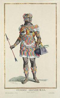
Femme Honduras.
d'apres Sonisbec.
A Paris chez Duflos, rue St. Victor. [n.d. c.1787.]
Engraving with hand colour. 277 x 163mm.
Strong contemporary colour in gold leaf line surround. ['A.D.P.R.' (Avec Privilege Du Roi) inscribed lower right].
[Ref: 2018] £130.00
(£156.00 incl.VAT)
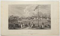
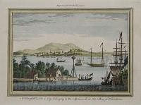
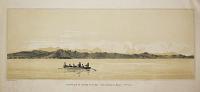
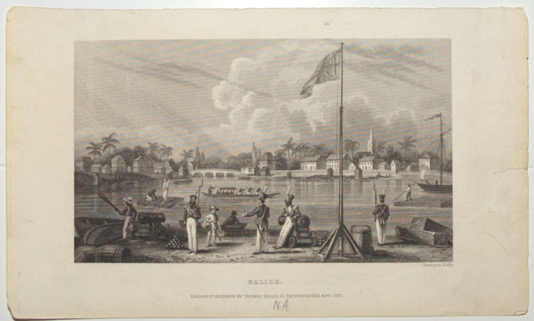
Balize.
Davenport, sculp.
London Published By Thomas Kelly, 17, Paternoster Row, 1837.
Steel engraving sheet 5½ x 9¼ (140 x 235mm). Repaired tears.
A scene of a river in Belize, a Carribean country in central America. Formally know as British Honduras, a British flag on a pole can be seen waving gently in the foreground, surrounded by a handful of soliders carrying weapons, one seems to be reprimanding a boy holding a dead bird, one of them casually leans on one of the two cannons located on the shoreline and the others stand guard. A man sits in his boat on the shore while another picks up a paddle seemingly about to set off. Two rafts are pushed around the water by men with poles, while a longer boat with four oarsmen glides across the water and a sailing ship with no sails appears to be moored on the right. The surrounding town and more boats can be seen in the distance.
[Ref: 54834] £80.00
(£96.00 incl.VAT)
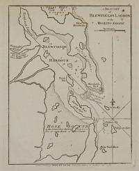
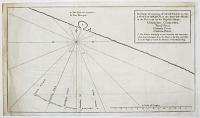
A Draught of Blewfields Lagoon on the Moskito Shore.
London, Printed for Robert Sayer, No.53, Fleet Street, as the Act directs, Jan 1.st 1788.
Engraving with large margins, paper watermarked. Plate 240 x 190mm (9½ x 7½"). Paper toning.
A rare plan of Blewfield's Lagoon on the east coast of Nicaragua. Abraham Blauvelt (Blewfield) was a Dutch privateer and explorer, who was responsible for mapping much of the east coast of Central America in the 1630s. Blauvelt was first recorded exploring the coasts of present day Honduras and Nicaragua in service of the Dutch West India Company. He later travelled to England in an effort to gain support to establish a colony in Nicaragua near the city where Bluefields, Nicaragua presently stands. Around 1640 Blauvelt became a privateer serving the Swedish East India Company and in 1644 he commanded his own ship successfully raiding Spanish shipping from a base in southwest Jamaica, today known as Blewfields Bay, and selling the cargo and prizes to the Dutch colony of New Amsterdam (New York). After peace between Spain and the Netherlands was reached with the signing of the Peace of Westphalia in 1648, Blauvelt, unable to stay in New Amsterdam, instead sailed to Newport, Rhode Island in early 1649 to sell his remaining cargo. However the colonial governor seized one of Blauvelt's prizes and with his crew arguing over their shares, the local colonists, fearing that Rhode Island would acquire a reputation of trading with pirates, forced Blauvelt to leave the colony. For the next several years Blauvelt commanded a French ship called La Garse, later living among the natives of Cape Gracias a Dios near the border of Honduras and Nicaragua, until the early 1660s when he was recruited for Christopher Myngs' raid on the Spanish colony of Campeche Bay in 1663.
[Ref: 30439] £420.00

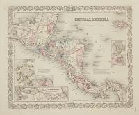
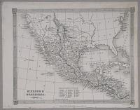
Central America 1. Including Yucatan, Belize, Guatemala, Salvador, Honduras, Nicaragua, and the Southern States of Mexico. B. Bahia, Bay_C. Cabo, Cape_C.ro Cerro, Hill_F. Fuerte, Fort_I. Isla, Island_L. Laguna, Lake_M. Monte, Mount_P. Puerto, Port_Pt. Punta, Point_R. Rio, River_S. S.ta, Santa, Saint_S.ra Sierra, Mountain ridge_V. Villa, Town_Vol. Volcano. Heights above the Sea in Yards.
J. & C. Walker sculp.t
Published under the Superintendence of the Society for the Diffusion of Useful Knoweldge. Published by Chapman and Hall, 186 Strand, 15. Oct. 1842.
Engraved map with hand-colour. 347 x 411mm (13¾ x 16¼"). Centre-fold, some slight creasing and tears around the fold.
A map of Central America showing Yucatan after it joined the Federal Republic of the United Mexican States in 1823. The map includes a Spanish to English key of translations.
[Ref: 30435] £160.00
Central America. No.55.
Published by J.H. Colton & Co. No.172 William St. New York. Entered according to Act of Congress in the Year 1855, by J.H. Colton, in the Clerk's Office of the District Court, of the United States for the Southern District of New York.
Engraved map with hand-colour. 394 x 470mm (15½ x 18½").
A map of Central America with five inset maps: Isthumus of Panamal Harbor of San Juan de Nicaragua; The "Nicaragua Route"; Manzanilla I. Aspinwall City Navy Bay; City of Panama. Accompanying sheet of descriptions on verso of mount. From "Colton's Atlas Of The World, Illustrating Physical And Political Geography. By George W. Colton. Accompanied By Descriptions Geographical, Statistical, And Historical, By Richard Swainson Fisher, M.D."
[Ref: 30440] £140.00
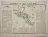
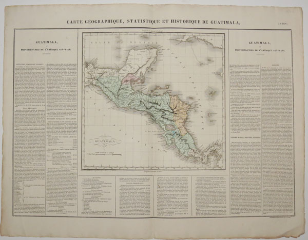
Carte Géographique, Statistique et Historique de Guatimala. (No. XLIV.)
Gravé par B. de Beaupré, Rue de Vaugirad No.81: à Paris. Les Montagnes, par Orgiazzi. Ecrit par Arnoul, Rue de Petit-Pont, No.26.
Fonderie et Imprimerie de J. Carez. [n.d. c.1825.]
Hand-coloured engraving with text and tables at sides and along bottom; also with accompanying sheet of further text. Map sheet 540 x 711mm (21¼ x 28"). Centrefold.
The map shows part of the Yucatan, Belize, Honduras, El Salvador, Guatemala, Nicaragua, Costa Rica and Panama. From "Atlas geographique, statistique, historique et chronologique des deux Ameriques et des iles adjacentes; traduit de l'atlas execute en Amerique d'apres Lesage, avec de nombreuses corrections et augmentations, par J.A. Buchon."
[Ref: 30446] £220.00
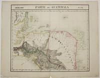
Partie du Guatemala. Amér. Sep. No.72.
[Dresse par Ph. Vandermaelen, lithographie par H. Ode.]
[n.d. c.1827.]
Hand coloured lithograph. 540 x 691mm (21¼ x 27¼"). Centrefold; paper chip at ends of folds. Slight repaired tear at top.
A detailed regional map of the area extending from the southern part of the Yucatan and the Golfe de Honduras and Golfe de Fonseca to Lac de Perlas. The map shows Indian tribes, city populations and covers Honduras, parts of Guatemala, El Salvador, Belize and Nicaragua. From "Atlas universel de geographie physique, politique, statistique et mineralogique", the first atlas to have every map on the same scale, thus showing many remote areas in detail for the first time.
[Ref: 30445] £280.00
![[Guatemala] Retrato del General Morazan en la Campana de Guatemala de 1840.](img-thumbnail/jpegs/748.jpg)
[Guatemala] Retrato del General Morazan en la Campana de Guatemala de 1840.
Lith. Of E.W. Bouve.
[n.d. c.1840].
Lithograph. Sheet 425 x 300mm. A few worm holes in image and margins, neatly repaired old tear into top of image and traces of old folds along four sides of sheet outside image. Light foxing throughout. Laid on scrap sheet.
General Francisco Morazan [1792 - 1842] Central American statesman. He was elected President of Central America for two terms in the 1830s, struggling to keep the uneasy federation united against the many rebellions against his government. He introduced constitutional reforms and separated Church and State and is still honoured by liberals in Central America. He is regarded as a national hero in Honduras, where he was born.
[Ref: 748] £240.00
(£288.00 incl.VAT)
Map of the Gulf of Mexico, the Islands and Countries adjacent. For the Rev. Dr. Robertson's History of America. Vol.I.
By Tho.s Kitchin Sen.r Hydrographer to his Majesty.
Published according to Act of Parliam.t Sept.r 29th. 1777 by W. Strahan; and T. Cadell in the Strand.
Copper engraving. Plate 324 x 481mm (12¾ x 19"). Folds as normal; creasing and some repaired tears, some off setting.
A Map of the Gulf of Mexico including parts of Mexico and the United States, New Spain, parts of the Kingdom of Terra Firme, the Caribbean Islands, Hayti or Hispaniola, Cuba and Lucayo or Bahama Islands. From Dr William Robertson, D.D. (1721-1793) "The History of America", 1777. He was a Scottish historian, minister of religion and Principal of the University of Edinburgh.
[Ref: 23841] £160.00
A View of Truxillo a City belonging to the Spaniards in the Bay of Honduras. Engraved for Drakes Voyages.
[n.d. c.1768.]
Engraving. Plate 190 x 268mm (7½ x 10½"). Small tear into upper edge of plate.
A view of Trujillo on the northern Caribbean coast of Honduras. From Edward Cavendish Drake's "A new universal collection of authentic...Voyages and Travels from the earliest accounts to the present time". See Ref: 19209 for a hand-coloured version. RMG: PAD0909.
[Ref: 30438] £160.00
(£192.00 incl.VAT)
![[Trujillo] A View of Truxillo Bay and City on the Coast of Honduras.](img-thumbnail/jpegs/55167.jpg)
[Trujillo] A View of Truxillo Bay and City on the Coast of Honduras.
T. Bowen sc.
London, Republished 4th June 1796 by Robert Wilkinson, No 58, Cornhill. c. 1810
Coloured engraving. Printed area 245 x 375mm (9¾ x 14¾"). Stuck in mount.
A view of Trujillo, once the capital of Spanish Honduras, but abandoned as being too vulnerable to pirate attacks.
[Ref: 55167] £320.00
A View of Truxillo a City belonging to the Spaniards in the Bay of Honduras.
Engraved for Drakes Voyages. [London, 1768.]
Hand coloured engraving, 185 x 270mm. 7¼ x 8½". Laid down.
Trujillo on the northern Caribbean coast of Honduras, Central America. From Edward Cavendish Drake's 'A new universal collection of authentic... Voyages and Travels from the earliest accounts to the present time'. BL 000979372.
[Ref: 19209] £130.00
(£156.00 incl.VAT)
Carte Générale du Mexique et de la partie Sud-Ouest des Etats-Units. Carte de l'Amérique Centrale ou des Républiques de Guatemala, San-Salvador, Honduras, Nicaragua, Costa-Rica. Atlas Universel en 67 feuilles No.61. No. 44.
Dressee par A. Brué, Géographe Revue par E. Levasseur Membre de l'Institut.
Institut Géographique de Paris Ch. Delagrave Éditeur de la Société de Géographie 58 rue des Ecoles. [n.d. c.1875].
Hand-coloured engraving. 610 x 475mm (24 x 18¾"). Horizontal centrefold.
A map that shows geography, cities, towns, railroads, and political boundaries in Mexico, Central America, and the southwestern United States. From "Atlas Universel De Geographie Physique, Politique, Ancienne Et Moderne, Contenant Les Cartes Generales Et Particulieres De Toutes Les Parties Du Monde...".
[Ref: 30447] £220.00
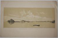
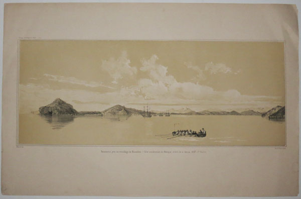
Panorama pris du moillage de Mazatlan (Cote occidentale du Mexique) a bord de la Vénus, 1837. (1.re Feuille).
Ménard del.t.
Lith. de Thierry frères, Paris.
Tinted lithograph. Sheet: 360 x 550mm (14 x 21¾'').
A view of the bay of Mazatlan on the west coast of Mexico, from the Pacific. A plate from 'Atlas Pittoresque of du Petit-Thouars' Voyage Autour du Monde sur La Fregate La Venus'.
[Ref: 51120] £180.00
(£216.00 incl.VAT)
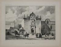
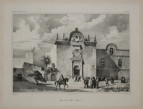
Eglise de San Blas (Mexique.) Voyage de la frigate Vénus. Atlas Pittoresque.
Ménard del.t. Lith. Thierry frères, Paris. Lith. par P. Blanchard, lith.
[n.d., c.1841.]
Lithograph, printed on chine collé. Printed area: 210 x 275mm (8¼ x 11''), with very large margins.
A view of a church in the Mexican town of San Blas. A plate from 'Atlas Pittoresque of du Petit-Thouars' Voyage Autour du Monde sur La Fregate La Venus'.
[Ref: 50944] £180.00
(£216.00 incl.VAT)
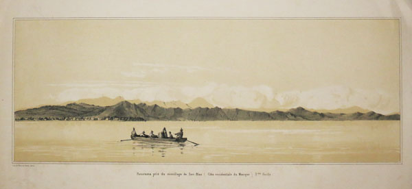
Panorama pris du moillage de San-Blas (Cote occidentale du Mexique) 3.me Feuille.
Lith. de Thierry frères, Paris.
Tinted lithograph. Sheet: 360 x 550mm (14 x 21¾''), with large margins.
A view of the bay of San Blas in Mexico, from the Pacific. A plate from 'Atlas Pittoresque of du Petit-Thouars' Voyage Autour du Monde sur La Fregate La Venus'.
[Ref: 50941] £180.00
(£216.00 incl.VAT)
![[Aztec portraits.]](img-thumbnail/jpegs/59923.jpg)
[Aztec portraits.]
[London: Awnsham and John Churchill, 1704.]
Two engravings, 18th century watermark. Each 210 x 165mm (8¼ x 6½"), set in letterpress, printed back to back, large margins.
Portraits of five Aztec rulers, including Moctezuma II & Cuauhtémoc (the last ruler independent of the Spanish), a portrait of a Mexican soldier, Tlaloc the Rain god, and an illustration of a mine shaft. From 'A Collection of Voyages and Travels'.
[Ref: 59923] £65.00
(£78.00 incl.VAT)
view all images for this item
Mexico & Guatemala.
Drawn & Engraved by Alex.r Findlay.
London. Published by Thomas Kelly, 17 Paternoster Row, 1842.
Steel-engraved map. Sheet 210 x 270mm, 8¼ x 10½". Binding stitches in edge.
Mexico south to Panama. Despite being published during the short-lived Republic, Texas appears to be shown as part of Mexico.
[Ref: 13231] £60.00
![[Mexico] El General Javier Mnia, Copia del Retrato Original Pintado.](img-thumbnail/jpegs/17279.jpg)
[Mexico] El General Javier Mnia, Copia del Retrato Original Pintado. Pocos dias antes de su salida de Inglaterra, Que existe en poder de Tomas Broadwood.
Ja.s Harrinson Pinx.t Tho.s Wright Sculp.t.
Publicada en Londres por R. Ackermann. [n.d. c.1820.]
Stipple. 228 x 145mm. 9 x 5¾". Cut to the plate bottom and sides. Creasing and soiling to the lower edger.
Francisco Javier Mina (1789-1817) was a Spanish Lawyer and army officer and a Mexican revolutionary. As a rebel and guerilla who fled during the Peninsula War, he sought to form a large enough group to engage in full-scale military actions, but he was captured in 1810; later released following the collapse of Napoleon's governent in 1814. On returning to Spain he was appalled by the abolition of the democratic state, which was previously established under the Constitution of 1812. He was ironically forced to flee to France, where he was convinced by Servando Teresa de Mier, a Roman Catholic priest, that he could attack Spain from the colonies. Therefore in 1816 he took two ships to attack Spanish shipping in the Gulf of Mexico and setup a base in Texas. Two failed attempts, one escape later and a final capture in 1817 led to his execution by firing squad in the Fuerte de los Remedios region in Guanajuato, Mexico, aged only twenty-seven.
[Ref: 17279] £85.00
(£102.00 incl.VAT)
The Form of cruising off Acapulca on the coast of Mexico in the South Seas, in the year 1742 by His Majesty's ships, Centurion, Gloucester, Tryall Prize, Carmila Prize, Carmin Prize.
[London: J. and P. Knapton, 1748.]
Engraved map. 255 x 440mm (10 x 17¼"). Narrow margin on right, binding folds.
A sketch map illustrating how Commodore George Anson's fleet guarded the approaches to Acapulco as they waited for the Spanish treasure galleon, the 'Nuestra Señora de Covadonga' to leave. However they had been spotted, so they broke off their vigil and crossed the Pacific where they eventually ambushed the treasure ship, capturing 1,313,843 pieces of eight and 35,682 ounces of silver. From George Anson's 'A Voyage round the world in the years MDCCXL, I, II, II, IV', probably engraved by R.W. Seale.
[Ref: 45647] £180.00
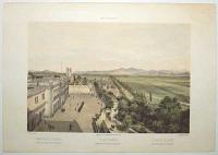
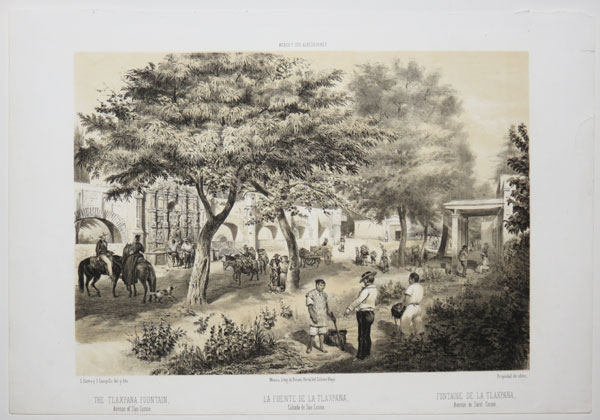
The Tlaxpana Fountain, Avenue of San Cosme. México Y Sus Alrededores.
C. Castro y J. Campillo del. y lito. México, Litog. de Decaen, Portal del Coliseo Viejo.
Propiedad del editor. [n.d., c.1856.]
Tinted lithograph. Sheet: 295 x 430mm (11¾ x 17"). Repaired tear in right edge.
A view of the Tlaxpana Fountain in Mexico city. A plate from 'Mexico y Sus Alrededores. Coleccion de Monumentos, Trajes y Paisajes Dibujados al Natural y Lithografiados por los Artistas Mexicanos', published in Mexico City in 1855-1856 and primarily the work of Mexican artist Casimiro Castro. Title in English, Spanish and French.
[Ref: 46670] £260.00
(£312.00 incl.VAT)
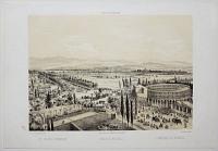
View of the Valley of Mexico, taken from the Heights of Chapultepec. México Y Sus Alrededores.
C. Castro del. lit.
Propiedad del editor [n.d., 1856].
Tinted lithograph with hand colour. Sheet: 320 x 455mm (12½ x 18"). Stitch holes in top margin.
A view from Chapultepec Castle looking across the fields of what is now Chapultepec Park to Mexico City. Soldiers are on parade in the castle. The title is repeated in Spanish and French. A plate from 'Mexico y Sus Alrededores. Coleccion de Monumentos, Trajes y Paisajes Dibujados al Natural y Lithografiados por los Artistas Mexicanos', published in Mexico City in 1855-1856. Most of the plates were after Casimiro Castro (1826-89), a leading Mexican graphic and landscape artist
[Ref: 58108] £260.00
(£312.00 incl.VAT)
The Bucareli Promenade. México Y Sus Alrededores.
C. Castro y J. Campillo del. y lito. México, Litog. de Decaen, Portal del Coliseo Viejo.
Propiedad del editor. [n.d., c.1856.]
Tinted lithograph. Sheet: 295 x 430mm (11¾ x 17").
A view of the Paseo de Bucareli in Mexico City. A plate from 'Mexico y Sus Alrededores. Coleccion de Monumentos, Trajes y Paisajes Dibujados al Natural y Lithografiados por los Artistas Mexicanos', published in Mexico City in 1855-1856 and primarily the work of Mexican artist Casimiro Castro. Title in English, Spanish and French.
[Ref: 46672] £290.00
(£348.00 incl.VAT)
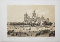
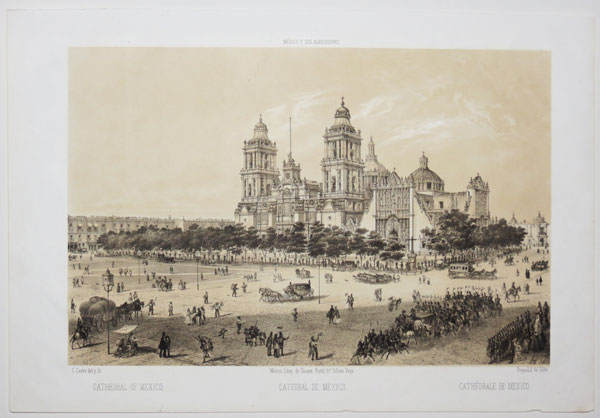
Cathedral of Mexico. México Y Sus Alrededores.
C. Castro y J. Campillo del. y lito. México, Litog. de Decaen, Portal del Coliseo Viejo.
Propiedad del editor. [n.d., c.1856.]
Tinted lithograph. Sheet: 295 x 430mm (11¾ x 17").
A view of the Metropolitan Cathedral in Mexico City built between 1573-1813. A plate from 'Mexico y Sus Alrededores. Coleccion de Monumentos, Trajes y Paisajes Dibujados al Natural y Lithografiados por los Artistas Mexicanos', published in Mexico City in 1855-1856 and primarily the work of Mexican artist Casimiro Castro. Title in English, Spanish and French.
[Ref: 46673] £280.00
(£336.00 incl.VAT)
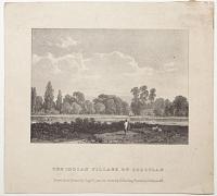
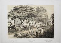
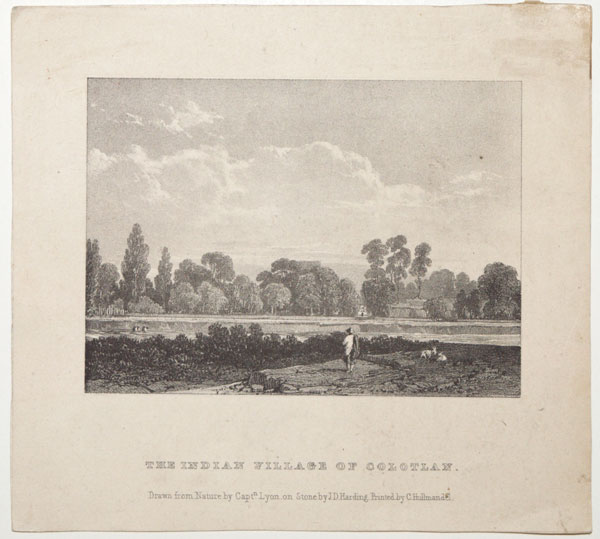
The Indian Village of Colotlan.
Drawn from Nature by Capt.n Lyon. on stone by J.D. Harding. Printed by C. Hullmandel.
[London: J. Dickinson, 1827.]
Rare lithograph. Sheet 160 x 170mm (6¼ x 6¾"). Glue stains in edge.
Colotlán, in Jalisco, Mexico. A plate from 'The Sketch Book of Capt.n G.F. Lyon R.N.' Captain George Francis Lyon (1795-1832) went to sea at the age of thirteen and wrote and illustrated books on his travels, which included crossing the Sahara, serving under Parry as commander of the 'Hecla' and following Frankin into Hudson's Bay. He went to Mexico in 1826 as commissioner of the Real del Monte and Bolaños Mining Companies, dying on a voyage from Buenos Aires to London.
[Ref: 52324] £90.00
(£108.00 incl.VAT)
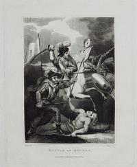
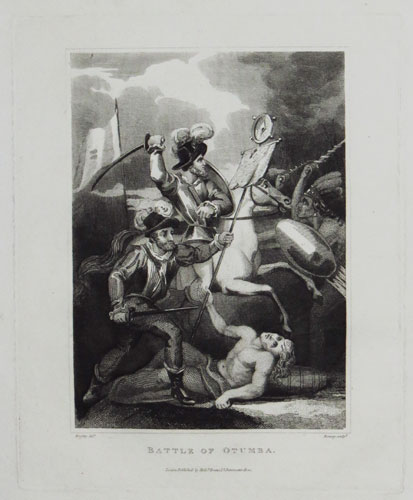
Battle of Otumba.
Brighty del.t. Romney sculp.t.
London Published by Rich.d Evans, 17, Paternoster Row. [n.d., c.1817.]
Engraving. Plate: 200 x 165mm (8 x 6½'') very large margins.
A historical scene showing the Battle of Otumba which was fought between the Spanish under Cortes and the Aztecs in what is now Mexico.
[Ref: 48302] £50.00
(£60.00 incl.VAT)
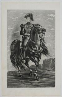
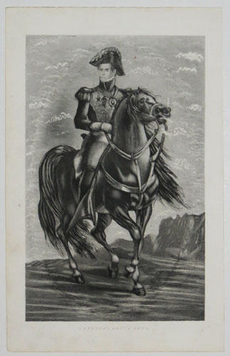
General Santa Anna.
[n.d., c.1825.]
Aquatint. Sheet 230 x 145mm (9 x 5¾"). Trimmed within the plate, some surface subbing around the face.
Equestrian portrait of a young Antonio López de Santa Anna (1794-1876) in uniform. Although he played a significant role in the creation of an independent Mexico, his later career saw Mexico lose over half its territory, including Texas.
[Ref: 51472] £140.00
(£168.00 incl.VAT)
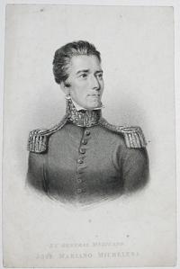
El General Megicano José Mariano Michelena.
E. Cooper.
[n.d., c.1850.]
Steel engraving. Sheet 170 x 110mm (6¾ x 4¼"). Trimmed bit dusty.
José Mariano Michelena (1772-1852), a Spanish soldier who campaigned for New Spain's independence from Spain during the Napoleonic Wars. After being sent to Spain, he fought in the Peninsula Wars (including the capture of Bayonne in 1814), before returning to Mexico when it became independent in 1822. After the abdication of Emperor Agustín de Iturbide in 1823, he was acting president until elections could be held, handing over power peacefully. Afterwards he was minister plenipotentiary to Great Britain, and travelled around Europe and the near East. In Arabia he bought coffee plants and successfully grew them back in Mexico, thus introducing them to the country.
[Ref: 51665] £60.00
(£72.00 incl.VAT)
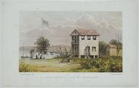
Gorgon Villa, with a view of Grey Town, March, 1860.
H. Sewell, Esq. R.N. del. Vincent Brooks, lith.
[c.1860.]
Chromolithograph. 140 x 217mm. 5½ x 8½".
A view of the Gorgon Villa looking over to Greytown, Nicaragua; know as San Juan del Norte. In 1762, the settlement was captured by an alliance of the Miskitos, Zambos and English, however control passed to the Spanish to control the trade and commercial treaties. In 1821, with the independence of Central America, the town was left free, but in 1841, the Miskitos took control with British assistance and in 1848 the town was occupied directly by the British. In 1860 the town was legally placed under the sovereignty of Nicaragua and removed from Miskito control, but remained de facto under British protection through until the end of century.
[Ref: 20411] £60.00
(£72.00 incl.VAT)
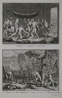
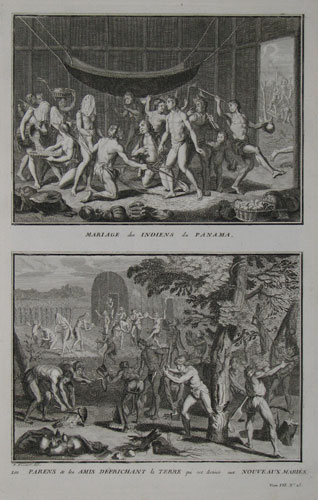
Mariage des Indiens de Panama. Les Pariens & les Amis Défrichant la Terre que est destinée aux Nouveaux Mariés.
B. Picart, del. Tom. VII. No. 25.
[Paris: Antoine Laporte, c.1789.]
Copper engraving. Bookplate. Plate 344 x 217mm. Sheet 391 x 246mm. Some creasing in the bottom right-hand corner.
Two scenes. 1. The marriage of Indians from Panama. Day-to-day business of cutting, selling, playing and harvesting goes on around the coupld on the centre who are to be wed. The woman primarily naked except a loin cloth and veil - draped over her head. 2. The parents and friends clear the Earth that is intended for the newly weds. The digging and sowing of seeds, and the felling of trees to create an area and habitable environment for the newly married couple. Published in Jean Frederic Bernard's monumental "Cérémonies et coutumes religieuses de tous les peuples du monde" (Religious Ceremonies and Customs of All the Peoples of the World). 'The world's first encyclopedia of religions, the heavily illustrated, detailed general survey treating all religions dispassionately and as notionally equal, was composed and published in Amsterdam under the title 'Cérémonies et coutumes religieuses de tous les peuples du monde' in seven large volumes between 1723 and 1737 by a group of radical, intellectually subversive Huguenot refugees' (Jonathan Israel, 'How the light came in', TLS June 21 2013).
[Ref: 12510] £65.00
(£78.00 incl.VAT)
![[Panama] Marche des Indiens lors qu'ils vont rendre visite à quelcum, ou qu'ils vont à un Festin.](img-thumbnail/jpegs/60824.jpg)
[Panama] Marche des Indiens lors qu'ils vont rendre visite à quelcum, ou qu'ils vont à un Festin. P.220,
[after Lionel Wafer.]
[Amsterdam: Paul Marret, 1711.]
Engraving. 150 x 285mm (6 x 11¼"). Original binding folds.
Portraits of the Cuna king Lacenta, his wife and children, with his bodyguard, after Lionel Wafer (1640-1705), published in part of a French edition of Dampier's account of his voyages to Australia. Wafer, a Welsh ship's surgeon who served on buccaneer and privateer ships, was injured by a gunpowder blast while with Dampier near Cartagena in 1680. Left with the Cuna Indians on the Darien Isthmus to recover, he integrated with the tribe so much that when his crewmates returned they did not recognise him. In 1695 he published 'A New Voyage and Description of the Isthmus of America', which contained much about Cuna culture and the natural history of Panama. His glowing account influenced the infamous 1698 Darien Scheme that nearly bankrupted Scotland: the 'Company of Scotland Trading to Africa and the Indies' hired him as an advisor and quoted his account in their promotional literature.
[Ref: 60824] £140.00
(£168.00 incl.VAT)
<<< Previous 1 Next >>>


![[Guatemala] Retrato del General Morazan en la Campana de Guatemala de 1840.](jpegs/748.jpg)


![[Trujillo] A View of Truxillo Bay and City on the Coast of Honduras.](jpegs/55167.jpg)


![[Aztec portraits.]](jpegs/59923.jpg)

![[Mexico] El General Javier Mnia, Copia del Retrato Original Pintado.](jpegs/17279.jpg)


![[Panama] Marche des Indiens lors qu'ils vont rendre visite à quelcum, ou qu'ils vont à un Festin.](jpegs/60824.jpg)