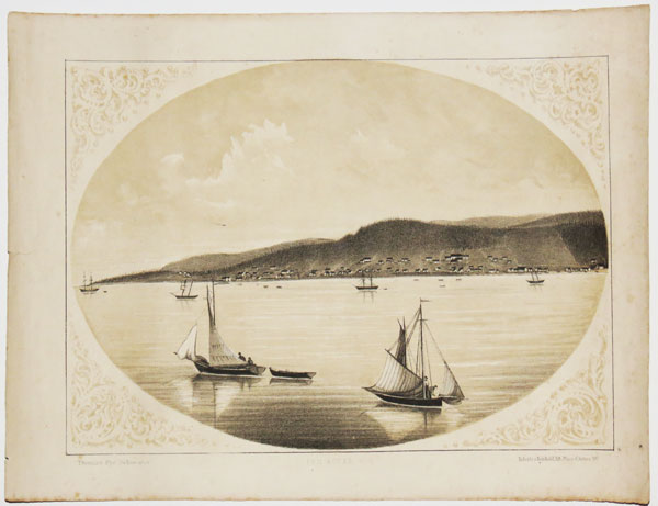
Fox River. C.E.
Thomas Pye, Delineator. Roberts & Reinhold, lith. Place d'Armes, Mt.l.
[Montreal: John. Lovell, 1866.]
Tinted lithograph, rare. Sheet 260 x 340mm (10¼ x 13½"). Some spotting.
The Riviere au Renard on the Gaspé Peninsula at the mouth the Saint Lawrence River. From Thomas Pye's 'Canadian Scenery: District of Gaspé. Beautifully Illustrated with Tinted Lithographs, from Photographs by the Author'.
[Ref: 33876] £190.00
(£228.00 incl.VAT)
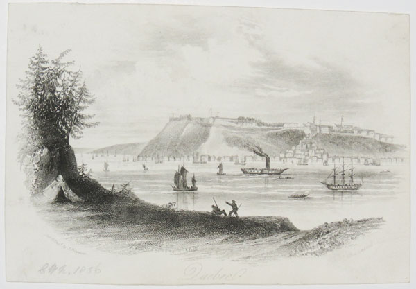
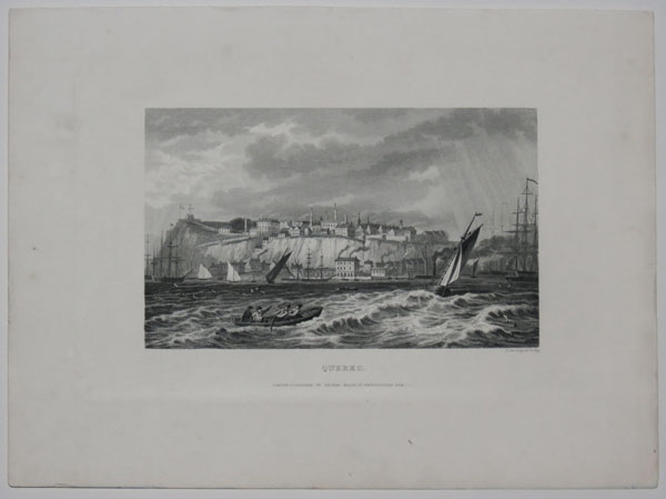
Quebec
Pub. & eng.d by J. Newman [ill.]Row, London [c.1836]
Steel engraving, sheet 115 x 165mm (4½ x 6½"). Trimmed.
View of Quebec, Canada, across the Saint Lawrence River.
[Ref: 41650] £45.00
(£54.00 incl.VAT)
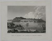
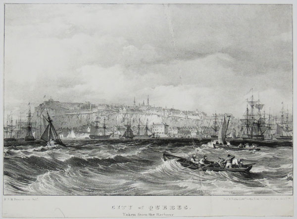
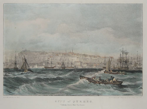
City of Quebec, Taken from the Harbour.
R.S.M Bouchette Delt.
Day & Haghe, Lith.rs to the King 17 Gate St. Lin. Inn F.ds.
Rare lithograph. Sheet: 155 x 210mm (6 x 8¼''). Trimmed, vertical crease.
A view of Quebec from the harbour, after a drawing by Joseph Bouchette (1774-1841) who was a landowner and member of the militia who served as Canadian Surveyor-General of British North America. Abbey 622: Plate 7.
[Ref: 50017] £70.00
(£84.00 incl.VAT)
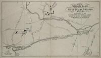
Map of the Phosphate Lands in the Provinces of Quebec and Ontario Canada. The Property of the Anglo Canadian Phosphate Co. Ltd. Shewing the Facilities for Transportation to Montreal by Rail and Water.
A.S. Cattell & Co., Eng.
[n.d., c. 1880.]
Lithograph, image area 200 x 360mm. Splits to binding folds.
[Ref: 1184] £130.00
City of Quebec. Taken from the Harbour.
R.S.M. Bouchette del.t. Day & Haghe, Lith.rs to the King, 17 Gate St. Linc. Inn Fds.
[London: Longman, Rees, Orme, Brown, Green & Longman, 1832.]
Coloured lithograph, printed area 160 x 205mm. Paper fault across image.
From Bouchette's 'British Dominions in North America'. Abbey: Travel, 622.
[Ref: 733] £80.00
(£96.00 incl.VAT)
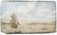
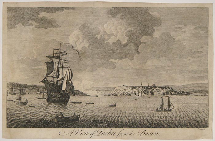
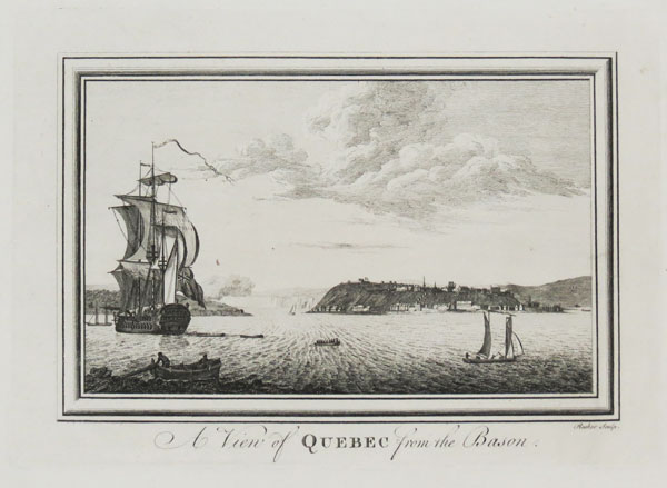
A View of Quebec from the Bason. Painted from the Drawing of Hen.y Smith Esq. by Francis Swain.
London Printed for J. Bowles in St. Pauls Church Yard, F. Bakewell & H. Parker, opposite Birchin Lane in Cornhil, Robt. Sayer, at the Golden Buck in Fleet Street [approx. 1770].
Engraving with hand-colouring, sheet 270 x 455mm (10½ x 18"). Trimmed to image and pasted on card with thick black border around edges and text cut out and pasted verso (standard 18th century presentation); damaged.
Large view of Quebec, Canada, with thirty-point key. This print was the basis of several smaller and later views of the city. For other views of Quebec derived from this see refs. 10976, 25851, etc.
[Ref: 41714] £320.00
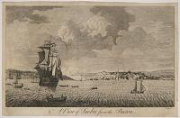
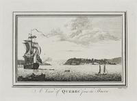
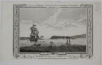
A View of Quebec from the Bason.
F.P. Sc.
[n.d., c.1770.]
Engraving, sheet 160 x 250mm. 6¼ x 9¾". Trace of two vertical folds, as normal. Trimmed within plate.
Quebec in Canada, a British warship and other boats in the foreground. Plate to an 18th century book or magazine. From the Capper album.
[Ref: 10976] £80.00
(£96.00 incl.VAT)
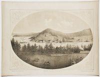
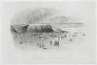
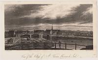
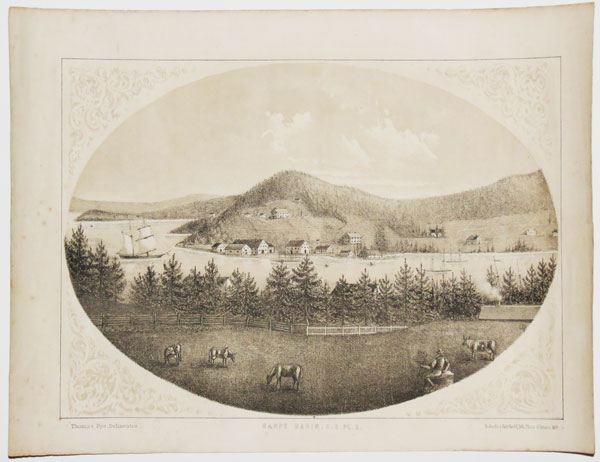
Gaspe Basin, C.E. Pl. 2.
Thomas Pye, Delineator. Roberts & Reinhold, lith. Place d'Armes, Mt.l.
[Montreal: John. Lovell, 1866.]
Tinted lithograph, rare. Sheet 260 x 340mm (10¼ x 13½"). Some spotting & creasing.
View of the harbour at Gaspé at the mouth the Saint Lawrence River, an important cod fishery base. It was herre that Jacques Cartier landed in 1534 and claimed Canada for France. From Thomas Pye's 'Canadian Scenery: District of Gaspé. Beautifully Illustrated with Tinted Lithographs, from Photographs by the Author'.
[Ref: 33871] £180.00
(£216.00 incl.VAT)

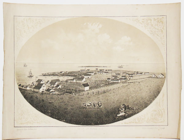
Point St Peter. C.E.
Thomas Pye, Delineator. Roberts & Reinhold, lith. Place d'Armes, Mt.l.
[Montreal: John. Lovell, 1866.]
Tinted lithograph, rare. Sheet 260 x 340mm (10¼ x 13½"). Some spotting, small tear in margin.
A settlement on the Gaspé Peninsula at the mouth the Saint Lawrence River. From Thomas Pye's 'Canadian Scenery: District of Gaspé. Beautifully Illustrated with Tinted Lithographs, from Photographs by the Author'.
[Ref: 33873] £180.00
(£216.00 incl.VAT)
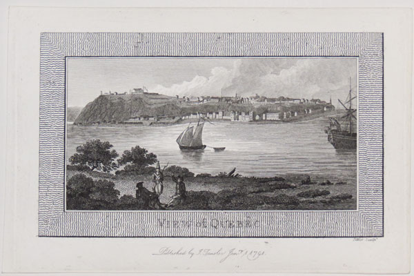
View of Quebec.
Fittler sculp.t.
Published by J. Trsuler Jan.ry. 1 1791.
Engraving. 190 x 130mm (7½ x 5). Trimmed to platemark.
View of Quebec. Illustration from Dr John Trusler's 'The Habitable World Described' (c1788-1806).
[Ref: 32130] £120.00
(£144.00 incl.VAT)
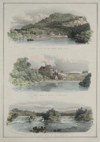
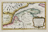
![Pasbebiac, C.E., Pl. 2. [and] 3.](img-thumbnail/jpegs/20901.jpg)
Pasbebiac, C.E., Pl. 2. [and] 3.
Thomas Pye, Delineator. Roberts & Reinhold, lith. Place d'Armes, Mtl.
[Montreal, Canada: J. Lovell, c.1866.]
Two hand coloured lithographs on one sheet (with captions). Sheet 330 x 245mm, 13 x 9¾". Some finger soiling; two nicks to lower margin, else fine.
Paspébiac, on the Gaspé Peninsula on the south shore of the Saint Lawrence River, was founded by Charles Robin, entrepreneur from the Isle of Jersey, in 1767 as Quebec's first cod fishing port. From Thomas Pye's 'Canadian Scenery: district of Gaspe´'. Library of Congress 01016911. BL 008611742.
[Ref: 20901] £160.00
(£192.00 incl.VAT)
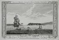
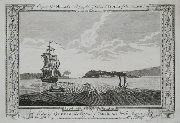
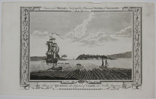
A View of Quebec the Capital of Canada, in North America. Engraved for Millar's New, Complete & Universal System of Geography.
Roberts sculp.
[London: A. Hogg, c.1782.]
Copper engraving, 210 x 310mm. 8¼ x 12¼". Repaired hole to upper right of image.
Prospect of Quebec, Canada; a British warship and other boats on the Saint Lawrence River in foreground. In distinctive decorative border, from George Henry Millar's 'The new and universal System of Geography, being a complete history and description of the whole world. ...' 1782.
[Ref: 16685] £75.00
(£90.00 incl.VAT)
A View of Quebec from the Bason.
Rooker sculp.
[n.d. c.1780.]
Engraving, with large margins. Plate 178 x 254mm. 7 x 10". Crease through upper left corner of image and sheet.
A British ship in the foreground with other vessels around, and the City of Quebec in the distance. For a related view see ref. 25851
[Ref: 25853] £75.00
(£90.00 incl.VAT)
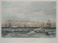
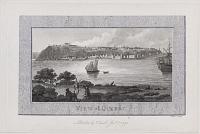
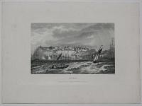
Quebec, Canada
Rock & Co., London [c.1850]
Steel engraving, sheet 120 x 185mm (4¾ x 7½").
View of Quebec from the busy Saint Lawrence river.
[Ref: 46016] £65.00
(£78.00 incl.VAT)
Quebec.
S. Davenport sculp.
London: Published by Thomas Kelly, 17, Paternoster Row [date printed but illegible, c.1850]
Engraving. Plate 145 x 229mm. 5¾ x 9".
Quebec seen with sailing vessels, a dinghy, steamer and larger tall-ships in the foreground on the Saint Lawrence River. Published in Kelly's "New and Universal English Dictionary".
[Ref: 25858] £50.00
(£60.00 incl.VAT)
A View of Quebec the Capital of Canada, in North America. Engraved for Millar's New Complete & Universal System of Geograhy.
Roberts sculp.
[London, 1782.]
Engraving, with large margins. Plate 209 x 310mm. 8¼ x 12¼". Hole centre-right.
A British ship in the foreground with other vessels around, and the City of Quebec in the distance. From George H. Millar's "New and Universal System of Geography". In the Library of Congress; for a related view see ref. 25853.
[Ref: 25851] £75.00
(£90.00 incl.VAT)
View of Quebec, The Capital of British America.
W.M. Craig del. T. Dixon sc.
Published by Henry Fisher, Caxton, London, 1825.
Engraving. 210 x 272mm. 8¼ x 10¾". Creasing along lower edge.
A view of Quebec, Canada seen from across the Saint Lawrence River; the fortifications of the city can be seen in the background. A British Naval vessel seen at anchor to the right with men rowing away to shore; three naval officers on the shore in the foreground, one looking through a telescope.
[Ref: 25859] £80.00
(£96.00 incl.VAT)
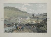
![[Port Levi, Quebec.]](img-thumbnail/jpegs/6815.jpg)
[Port Levi, Quebec.]
[Painted by Lieut. J. Corbett, R.N.]
Pencil and ink wash. Sheet 145 x 270mm. Creased, with some spotting.
With a paddle steamer in the foreground. Lieutenant John Corbett served with the Royal Navy from the late 1830s to the 1870s, travelling in the Mediterranean, Africa & the Far East. In 1851, serving on the 'Penelope', he took part in the storming of Lagos under heavy fire, spiking the guns of the fort, making Lagos a British Province. He was Commander of HMS 'Inflexible' during the Second Opium War (1856-60), which, in 1857, towed the gun-boat 'Starling' 10,000 miles to Hong Kong after it was damaged in a storm.
[Ref: 6815] £230.00
(£276.00 incl.VAT)
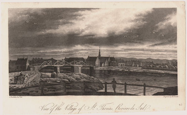
View of the Villag of St. Thomas, Riviere du Sud.
Drawn by J. Bouchette. Engraved by W. J. Bennett.
[W. Faden. 1815.]
Scarce aquatint. Sheet size: 145 x 240mm (5¾ x 9½"). Cut inside platemark.
A view of the village of St. Thomas, Québec, with Regents Bridge crossing the river in the centre, and a horse and cart appoaching from the left. From a 'Collection of Five Rural view of Québec' after Bouchette (Nicolet, Harrowers Mill, Lake Temiscouata, Isle aux Noir and Village of St. Thomas), published by W. Faden, 1815.
[Ref: 37239] £190.00
(£228.00 incl.VAT)
Trading Post on the River Aux Rats. The Forges, River St. Maurice. Falls of the Grande Mere, on the St Maurice.
Jos. Bouchette Jnr Dep.t sur. Gen.l delt. del.t. Day & Haghe, Lith.rs to Her Majesty.
[London: Longman, Rees, Orme, Brown, Green & Longman, 1832.]
Coloured lithograph, printed area 205 x 160mm.
From Bouchette's 'British Dominions in North America'. Abbey: Travel, 622.
[Ref: 734] £80.00
(£96.00 incl.VAT)
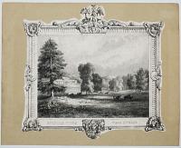
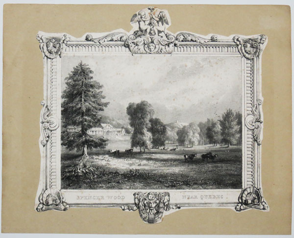
Spencer Wood Near Quebec.
[n.d., c.1865.]
Lithograph. Sheet: 260 x 285mm (10¼ x 11¼''). Trimmed and laid on album sheet with decorative border.
A view of a large mansion near Quebec, a house has stood on the site since 1780, though several different houses have been built since. The current house is now the Government House of Quebec.
[Ref: 50110] £180.00
(£216.00 incl.VAT)
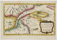
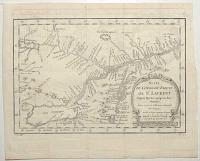
![[Canada] Carte du Cours du Fleuve de Saint Laurent Depuis Quebec jusqu'a la Mer en Deux Feuilles](img-thumbnail/jpegs/603.jpg)
[Canada] Carte du Cours du Fleuve de Saint Laurent Depuis Quebec jusqu'a la Mer en Deux Feuilles
Par S.Bellin, Ingenieur de la Marine
1761.
[Paris, Bellin, c.1761.]
Pair of coloured engravings, each c. 605 x 870mm.
Detailed charts of the St Lawrence River in North America from its mouth to Quebec. One of the insets is acknowledged to be after an English chart of the river published in 1760: this was surveyed by James Cook during the Seige of Quebec in 1759, a decade before his circumnaviation made him famous. How much of this chart is based on Cook's work is uncertain.
[Ref: 603] £920.00
view all images for this item
Carta del Corso del Flume di S. Lorenzo dalla foce fin sopra Quebec.
[after Jacques Nicolas Bellin.]
[Italian, c.1770.]
Engaved map with hand colour. 210 x 310mm (8¼ x 12¼").
A copy of Bellin's 1757 map of the mouth of the St Lawrence River, showing from Anticosti Island to just west of Quebec, from an Italian edition of Prevost's 'Histoire'. Originally published at the beginning of the Seven Years' War (1756-63), two years before Quebec fell to the English.
[Ref: 37065] £120.00
Carte du Cours du Fleuve de St Laurent Depuis Quebec jusqu'au Lac Ontarion. Pour servir à l'Histoire Générale des Voyages.
Par M.B. [Bellin] Ing. de la M.e 1757.
[Paris: Didot Libraire, c.1757.]
Engraved map, 18th century watermark. 210 x 310mm (8¼ x 12¼"). Binding folds, faint ink offset.
Map of the St Lawrence River, showing from Lake Ontario west to Quebec, with Montral and Lake Champelain. It was drawn in 1757 by Jacques Nicolas Bellin for Prevost's 'Histoire'. The Seven Years' War (1756-63) had already started: two years later Quebec fell to the English.
[Ref: 59453] £140.00
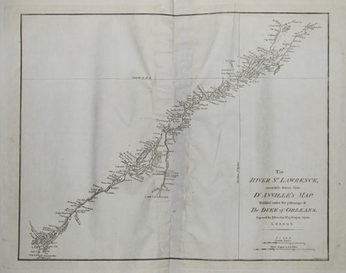
The River S.t Lawrence, accurately drawn from D'Anville's Atlas. Publish'd under the patronage of the Duke of Orleans.
Simpkins [**]
Engraved for Jno. Harrison, No 115 Newgate Street. London. [n.d., c.1788.]
Engraving. 360 x 465mm. Small hole just inside platemark.
From the mouth of the St Lawrence to Lake Ontario, after the French cartographer d'Anville.
[Ref: 3059] £230.00
Carte du Cours du Fleuve de St Laurent Depuis son Embouchure jusqu'au dessus de Quebec. Pour servir à l'Histoire Générale des Voyages.
Par M.B. Ing. de la M.e 1757.
[Paris: Didot Libraire, c.1760.]
Engraved map with fine hand colour. 210 x 310mm (8¼ x 12¼"). Very large margins.
Map of the mouth of the St Lawrence River, showing from Anticosti Island to just west of Quebec, engraved by Jacques Nicolas Bellin for Prevost's 'Histoire'. The Seven Years' War (1756-63) had already started: two years later Quebec fell to the English.
[Ref: 37064] £140.00
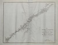
![[Canada] Suite de la Carte Réduite du Golphe de Saint Laurent](img-thumbnail/jpegs/604.jpg)
[Canada] Suite de la Carte Réduite du Golphe de Saint Laurent
A Paris chez Mr. Bellin, Ingenieur de la Marine
[1753.].
Coloured engraving, 910 x 570mm.
Detailed chart of the mouth of the St Lawrence River in North America.
[Ref: 604] £420.00
Kilborn's Mills, Standstead, L.r. Canada & The United States Settlements, Verm.t. South of the Privince Line _ Lat 45N.
On Stone by C. Haghe. Sketched by Col.n Bouchette.
[London: Longman, Rees, Orme, Brown, Green & Longman, 1832.]
Coloured lithograph, printed area 160 x 205mm.
From Bouchette's 'British Dominions in North America'. Abbey: Travel, 622.
[Ref: 732] £140.00
(£168.00 incl.VAT)
![Night. Royal York Hotel. Toronto. [In pencil.]](img-thumbnail/jpegs/47063.jpg)
Night. Royal York Hotel. Toronto. [In pencil.]
W.A. Howard. [Signed in pencil.]
[n.d., c.1930.]
Aquatint. Plate: 200 x 150mm (8 x 6") very large margins. Cockling.
A view of the large Royal York Hotel, now the Fairmont York Hotel, in Toronto which opened in 1929.
[Ref: 47063] £130.00
(£156.00 incl.VAT)
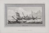
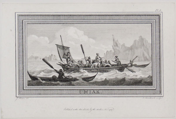
Umiak.
J. Ibbetson del. I Thornthwaite sculp.
Published as the Act directs, by the Author, Nov.r. 1787.
Engraving. 190 x 130mm (7½ x5"). Trimmed to platemark.
View of a Umiak, a boat used by Inuit peoples, and two canoes. Illustration from Dr John Trusler's 'The Habitable World Described' (c1788-1806).
[Ref: 32126] £120.00
(£144.00 incl.VAT)


![Pasbebiac, C.E., Pl. 2. [and] 3.](jpegs/20901.jpg)

![[Port Levi, Quebec.]](jpegs/6815.jpg)

![[Canada] Carte du Cours du Fleuve de Saint Laurent Depuis Quebec jusqu'a la Mer en Deux Feuilles](jpegs/603.jpg)


![[Canada] Suite de la Carte Réduite du Golphe de Saint Laurent](jpegs/604.jpg)

![Night. Royal York Hotel. Toronto. [In pencil.]](jpegs/47063.jpg)