Results 1-3 of 3
<<< Previous 1 Next >>>

Coast of China from Hie-che-chim Bay to Sun Moon Bay. Soundings in fathoms.
Weekly Dispach Atlas 139 Fleet Street. Engraved by Edw. Weller Duke St. Bloomsbury
Day & Son Lith.rs to the Queen
Lithograph printed in colours, printed area 440 x 305mm (17¼ x 12"). Folds.
Map of part of the coast of China, divided in two. The top section shows the coast of South China, from the island of Hainan and the Guangdong province, including Macao, Guangzhou (Canton) and Hong Kong. The lower section continues to the East, including Xiamen (Amoy), Quanzhou, Fuzhou, and as far as Taizhou.
[Ref: 36964] £260.00
(£312.00 incl.VAT)
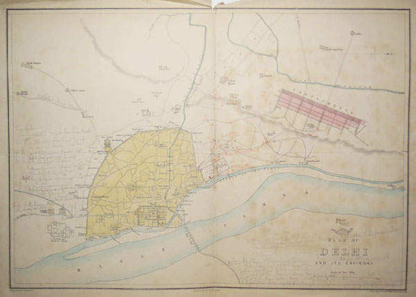
Plan of Delhi and its Environs.
Drawn and Engraved by Edw.d Weller, Duke Street, Bloomsbury. Day & Son, Lith.rs to The Queen.
[n.d., c.1857.]
Lithographic map with original hand colour. Printed area 330 x 440mm (13 x 17¼"). Cracks in folds., some spotting, mss. in crayon and pencil.
A map of Delhi published at the time of the siege during the India Mutiny of 1857. The manuscript gives details of the siege.
[Ref: 30801] £360.00
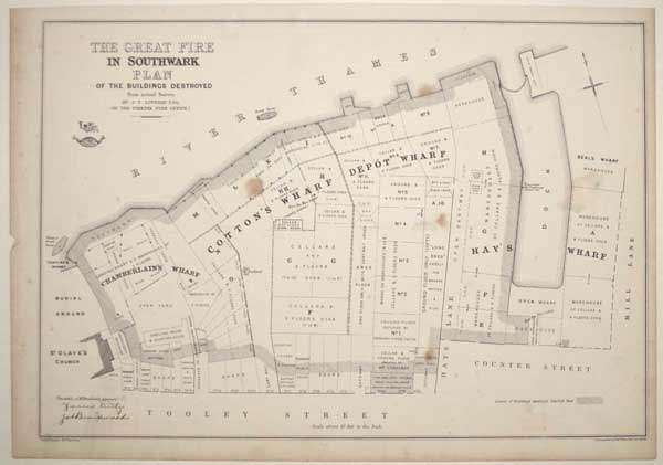
The Great Fire in Southwark. Plan of the Buildings Destroyed, from actual Survey. By J.T. Loveday Esq. (of the Phoenix Fire Office).
Lithographed by Edw.d Weller, Red Lion Square.
Weekly Dispatch Atlas, 139 Fleet Street [London: Cassell, 1861.]
Lithograph, printed area 310 x 450mm. Stains, laid on card.
The fire of 22 June 1861, which destroyed Cotton's Wharf & Chamberlain's Wharf, between Tooley Street and the Thames (site of London Bridge Hospital). It burned for over two weeks, destroying three acres and about £2 million of goods, including hemp, cotton, sacks of sugar, wooden casks of tallow, bales of jute, boxes of tea and spices. At least six men were killed, including the captain of the fire brigade, James Braidwood (whose facsimile signature appears lower left), crushed by a falling wall. James Thomas Loveday, 'Surveyor of Risks' of the Phoenix Fire Office spent two and a half years compiling plans of wharves and granaries along the Thames to assess fire risk for insurance purposes. This plan, detailing the owners of the affected buildings, was adapted for the 'Weekly Dispatch Atlas', a periodical. This volume held at Guildhall Library, covers an area on the south bank of the Thames from London Bridge to the Globe Granary at Rotherhithe and on the north bank from London Bridge to Tower Dock.
[Ref: 61751] £180.00
<<< Previous 1 Next >>>