Results 1-6 of 6
<<< Previous 1 Next >>>
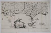
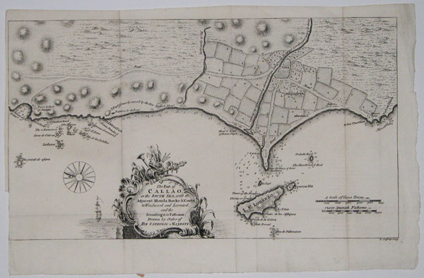
The Port of Callao, in the South Sea; with the Adjacent Islands, Rocks & Coasts, to Windward and Leeward, and the Soundings in Fathoms:
Drawn by Order of His Catholic Majesty.
[Gentleman's Magazine, London. 1753.]
Copper engraving. Image 208 x 362mm. 8¼ x 14¼". Cut along the left-hand edge. Three vertical folds. One horiztontal fold.
The coast of Peru from the Port of China to Tomocayo Point, showing Callao near Limea, and the Island of St Lorenzo and other landmarks such as the Old Men's Port.
[Ref: 17096] £95.00
![[Columbia] Plan of the Harbour of Carthagena.](img-thumbnail/jpegs/59319.jpg)
[Columbia] Plan of the Harbour of Carthagena.
T. Jefferys sculp.
[n.d., c.1768.]
Engraved map. 210 x 315mm (8¼ x 12½"), large margins. Slight mount burn.
A plan of Cartagena, the important Spanish port colony in Colombia, a frequent target of British attacks, particularly that of Admiral Vernon in 1741. This uncommon map was published in 'General Topography of North America and the West Indies' by Thomas Jefferys (c.1719-71).
[Ref: 59319] £350.00
![[Two exact cuttings from the 'Chart of the Atlantic Ocean, with the British, French & Spanish Settlements in North America, and the West Indies']](img-thumbnail/jpegs/41851.jpg)
[Two exact cuttings from the 'Chart of the Atlantic Ocean, with the British, French & Spanish Settlements in North America, and the West Indies']
[Engraved by Thomas Jefferys after 'John Green', aka Braddock Mead.]
[London c.1755-1770.]
Two sections of an engraved map, both with original hand colour. Image area c. 270 x 330mm (10½ x 13"). Trimmed.
Two cuttings exactly the same size showing the same section of Mead's 'Chart of the Atlantic Ocean', coloured differently to show English acquisitions. They show the top left quarter of the map, with North America from Labrador south to Florida and New Mexico, without the European and African coasts of the Atlantic. Whereas the original map, published 1753, was coloured to show the original colony charter limits for Virginia and Carolina (extending west across the Mississippi), both examples have been updated to 1755, showing the aftermath of Father Le Loutres War (1749-55), caused by the foundation of Halifax by the British (a line has been added marked 'Limits of Canada from Bellins Carte 1755). The earlier representation is coloured to show the situation at the begining of the Seven Years' War (French-Indian War, 1754-63), with the French controlling Canada; the later is apparently coloured to show the situation c.1770, when the 'Royal Proclamation of 1763', in which George III promised the Six Nation tribes that Europeans would not settle their lands west of the Appalachian Mountains, was renegotiated. Between 1768 and 1770, by the treaties of Hard Labour, Fort Stanwix and Lochaber, the English bought what is now Kentucky and West Virginia from the Cherokee, an area marked in green on the map. The original 'Chart of the Atlantic Ocean' is one of a six-sheet map of North and South America, an exceeding rare set. Obviously used by politican/military for comparison, maybe for a treaty?
[Ref: 41851] £950.00
view all images for this item
![[Chart containing the greater part of the South Sea to the South of the Line, with the Islands dispers'd throu' the same.]](img-thumbnail/jpegs/44645.jpg)
[Chart containing the greater part of the South Sea to the South of the Line, with the Islands dispers'd throu' the same.]
[Engraved by Thomas Jefferys after Braddock Mead.]
Publish'd according to Act of Parliament and Printed for Robert Sayer in Fleet Street and Thomas Jefferys in the Strand. [n.d., 1768.]
One sheet only (of six). Engraved map with border, scarce but damaged. Sheet 440 x 545mm (17¼ x 21½"). Trimmed into plate, losing title above top border, damage in plate. Laid onto old canvas, in turn glued to board. Tears.
The bottom left sheet of Braddock Mead's important six-sheet map, 'A Chart of North and South America including the Atlantic and Pacific Oceans with the nearest coasts of Europe, Africa and Asia.' It shows the pre-Cook outline of New Zealand, Espiritu Santo (then posited to be the east coast of Australia), the Solomon Islands and Marquesas, with the routes of the major explorers marked. Despite being designed to be joined, each sheet had a printed border and an individual title, missing in this example, allowing the sheets to be sold separately. The map was originally published by Jefferys alone in 1753 but, after backruptcy in 1766 forced him to take on partners, this second edition was published with Sayer, apparently unrevised. A third state, published by Sayer and Bennett in 1775, has Cook's mapping of New Zealand.
[Ref: 44645] £680.00
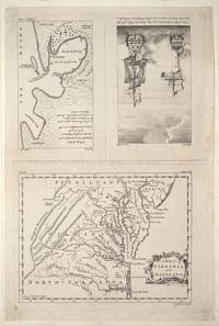
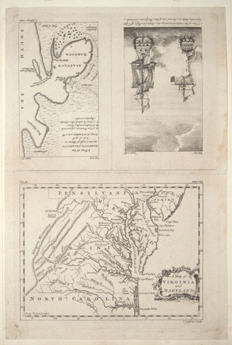
A Map of Virginia and Maryland. A View of the Centurion, taking the Acapulco Ship, off Cape Espiritu Santo, on Samal one of the Philipine Islands. A Plan of the Harbour of Acapulco on the Coast of Mexico.
[London: William Strahan et al, c.1766.]
Engraving. UNCUT SHEET, 340 x 220mm (13½ x 8¾"). Mounted on album paper.
A probably unique sheet, engraved by Thomas Jefferys for Smollett's 'Compendium of Authentic and Entertaining Voyages', but uncut and therefore unissued. It contains two maps, Virginia & Maryland and Acapulco, and a view of Geoge Anson's ship attacking the Spanish treasure ship in 1743.
[Ref: 52513] £480.00
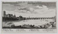
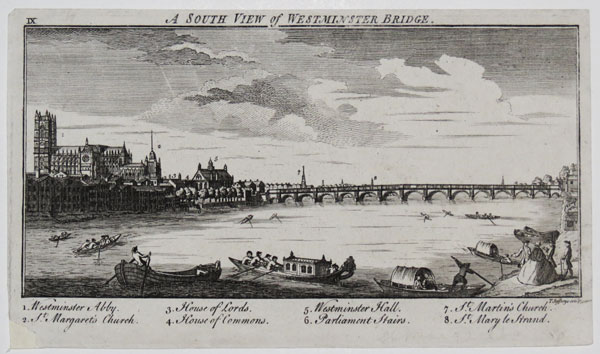
A South View of Westminster Bridge. IX. 1. Westminter Abby. 2. St Margaret's Church. 3. House of Lords. 4. House of Commons. 5. Westminster Hall. 6. Parliament Stairs. 7. St Martin's Church. 8. St Mary le Strand.
T. Jefferys sculp.
[n.d. c.1746]
Engraving. 120 x 209mm. 4¾ x 8¼". Trimmed; slight crease in sky and slight loss below image.
A south west view of Westminster Bridge with boats and passengers on the River Thames. Also including a key to the main buildings within the view. Collage: p5425460.
[Ref: 25746] £75.00
(£90.00 incl.VAT)
<<< Previous 1 Next >>>
![[Columbia] Plan of the Harbour of Carthagena.](jpegs/59319.jpg)
![[Two exact cuttings from the 'Chart of the Atlantic Ocean, with the British, French & Spanish Settlements in North America, and the West Indies']](jpegs/41851.jpg)
![[Chart containing the greater part of the South Sea to the South of the Line, with the Islands dispers'd throu' the same.]](jpegs/44645.jpg)